ANCOP Patrol BN Panjwayi, Kandahar Province - Afghanistan ...
ANCOP Patrol BN Panjwayi, Kandahar Province - Afghanistan ...
ANCOP Patrol BN Panjwayi, Kandahar Province - Afghanistan ...

You also want an ePaper? Increase the reach of your titles
YUMPU automatically turns print PDFs into web optimized ePapers that Google loves.
<strong>ANCOP</strong> <strong>Patrol</strong> <strong>BN</strong> <strong>Panjwayi</strong>, <strong>Kandahar</strong> <strong>Province</strong><br />
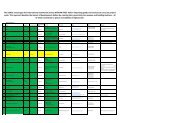
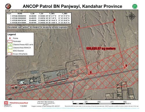
Point MGRS X_DD Y_DD X_DMS Y_DMS<br />
1 41R QQ 3585092532 65.484365 31.543663 65° 29' 3.71" E 31° 32' 37.19" N<br />
2 41R QQ 3595692095 65.485376 31.539702 65° 29' 7.35" E 31° 32' 22.93" N<br />
3 41R QQ 3624792166 65.488456 31.540282 65° 29' 18.44" E 31° 32' 25.02" N<br />
4 41R QQ 3614192604 65.487445 31.544252 65° 29' 14.80" E 31° 32' 39.31" N<br />
Perimeter lies within 35 meters of existing paved highway<br />
Legend<br />
!( Points<br />
Perimeter<br />
Cleared Areas AES certs<br />
Cleared Area MAACA<br />
IDIQ Cleared<br />
Known Minefields<br />
FOUO/Unclassified<br />
1:5,000<br />
!(<br />
1<br />
135,025.57 sq meters<br />
!(<br />
2<br />
0 125 250 375 500 Meters<br />
PCS WGS 1984 41N Datum<br />
Produced by AES USACE GIS<br />
JAN 2011<br />
Imagery courtesy of Team Buckeye DOI JAN 2011 Reasonable effort has been made to insure accuracy of map and associated data. USACE assumes no liability for actions made by the user of this map.<br />
N:\2011 NEW DATA STRUCTURE\2011 PROJECTS\ANP\<strong>Kandahar</strong>_<strong>Province</strong>\PAPS031101AP_<strong>ANCOP</strong><strong>Patrol</strong><strong>BN</strong><strong>Panjwayi</strong>_20JAN2011\MXDs\PAPS031101AP_<strong>ANCOP</strong>P<strong>BN</strong><strong>Panjwayi</strong>_20JAN2011.mxd<br />
!(<br />
4<br />
!(<br />
3<br />
μ
COMBINED SECURITY TRANSITION FORCES –<br />
CSTC-A<br />
SITE ASSESSMENT<br />
January 06, 2011<br />
<strong>ANCOP</strong> 2 nd Brigade 3 rd Battalion<br />
<strong>Panjwayi</strong> District, <strong>Kandahar</strong> <strong>Province</strong><br />
South Region<br />
MACTEC Project 6144100221.05.0P.00486<br />
CJ-ENG Project Number PAPS031101AP<br />
MACTEC ENGINEERING AND<br />
CONSULTING, INC.
SITE ASSESSMENT<br />
SHEET INTENTIONALLY LEFT BLANK<br />
<strong>ANCOP</strong> 2 nd Brigade 3rd Battalion <strong>Panjwayi</strong> District, <strong>Kandahar</strong> January 6, 2011<br />
MACTEC Project: 05.0P.00486 Page 1
January 06, 2011<br />
CDR Jeffrey Dryden, USN<br />
CJ-Engineering<br />
Camp Eggers<br />
Kabul, <strong>Afghanistan</strong><br />
SITE ASSESSMENT<br />
SITE: <strong>ANCOP</strong> 2 nd Brigade 3 rd Battalion<br />
<strong>Panjwayi</strong> District, <strong>Kandahar</strong> <strong>Province</strong><br />
South Region<br />
MACTEC Project 6144100221.05.0P.00486<br />
CJ-ENG Project Number PAPS031101AP<br />
CDR Dryden:<br />
MACTEC Engineering and Consulting, Inc. (MACTEC) has prepared this Site Assessment for CSTC-A, CJ-<br />
Eng under Task Order 75 of AFCEE Contract. This site assessment report includes preliminary discussion<br />
of issues pertaining to site acquisition and development.<br />
Very Respectfully,<br />
MACTEC Engineering and Consulting, Inc<br />
Ruth E. Howarth Pieter J. DePree, P.E.<br />
MACTEC ANP SA Manager MACTEC ANP SA Principal<br />
Registered Georgia, USA, 19637<br />
<strong>ANCOP</strong> 2 nd Brigade 3 rd Battalion <strong>Panjwayi</strong> District, <strong>Kandahar</strong> January 06, 2011<br />
MACTEC Project: 05.0P.00486 Page 2
SITE ASSESSMENT<br />
SHEET INTENTIONALLY LEFT BLANK<br />
<strong>ANCOP</strong> 2 nd Brigade 3 rd Battalion <strong>Panjwayi</strong> District, <strong>Kandahar</strong> January 06, 2011<br />
MACTEC Project: 05.0P.00486 Page 3
SITE ASSESSMENT<br />
Table of Contents<br />
1 Introduction ....................................................................................................................... 5<br />
2 Planned Development ...................................................................................................... 5<br />
3 Site Assessment ............................................................................................................... 5<br />
3.1 Site Location .................................................................................................................. 5<br />
3.2 Site Ownership .............................................................................................................. 5<br />
3.3 Existing Site Development ............................................................................................. 6<br />
3.4 Surrounding Site Use..................................................................................................... 6<br />
3.5 Site Topography ............................................................................................................ 6<br />
3.6 Site Geology .................................................................................................................. 6<br />
3.7 Site Seismicity ............................................................................................................... 7<br />
3.8 Site Drainage ................................................................................................................. 7<br />
3.9 Groundwater Resource.................................................................................................. 7<br />
3.10 Site Expansion Potential ................................................................................................ 7<br />
3.11 Mines and unexploded ordinance .................................................................................. 7<br />
3.12 Utilities ........................................................................................................................... 7<br />
3.13 Site Access .................................................................................................................... 7<br />
3.14 Area resources .............................................................................................................. 7<br />
4 Limitations ........................................................................................................................ 8<br />
TABLES<br />
Table 1 – Approximate Coordinates of Site Corners<br />
FIGURES<br />
Figure 1 – Site Location Map<br />
Figure 2 – Approx. Site Location on Soviet Topo Map<br />
Figure 3 - Site Location on Aerial Photograph Showing Corner Coordinates<br />
Figure 4 – Surrounding Land Use Map<br />
Figure 5 - Construction Resources<br />
APPENDIX A Site-Specific Official GoA Documents (Pashtu and English)<br />
Letter of Introduction and Translation<br />
Land Ownership Certificate and Translation<br />
Request Letter and Translation<br />
Notice of Completion of the Site Survey and Translation<br />
Site Sketch with Official Signatures and Translation<br />
APPENDIX B Site Photographs<br />
APPENDIX C Master Plan (under separate cover)<br />
<strong>ANCOP</strong> 2 nd Brigade 3 rd Battalion <strong>Panjwayi</strong> District, <strong>Kandahar</strong> January 06, 2011<br />
MACTEC Project: 05.0P.00486 Page 4
SITE ASSESSMENT<br />
<strong>ANCOP</strong> 2 nd Brigade 3 rd Battalion<br />
<strong>Panjwayi</strong> District, <strong>Kandahar</strong> <strong>Province</strong><br />
South Region<br />
MACTEC Project 6144100221.05.0P.00486<br />
CJ-ENG Project Number PAPS031101AP<br />
1 INTRODUCTION<br />
MACTEC Engineering and Consulting, Inc. (MACTEC) has completed a Site Assessment of approximately<br />
13.5 hectare parcel of land in <strong>Panjwayi</strong> District, northwest of <strong>Kandahar</strong> City, <strong>Kandahar</strong> <strong>Province</strong>,<br />
<strong>Afghanistan</strong>, for the Ministry of Interior (MoI). The site is currently open land and is planned for a facility for<br />
the for the Afghan National Police, <strong>ANCOP</strong> 2 nd Brigade 3 rd Battalion. The site visit was conducted on<br />
November 28, 2010.<br />
This effort was preliminary to a Master Planning effort and included assessment of the following:<br />
� Land Ownership<br />
� Adjacent Land Use<br />
� General Availability of Utilities on Site<br />
� General Description of Existing Structures and Facilities on Site<br />
� Access Roads<br />
� Proximity of Construction Materials and Labor<br />
� Proximity of Clinics, Fuel and Public Transportation<br />
This Site Assessment is part of the basis for a master plan for the Ministry of the Interior (MoI) which<br />
identifies required land area and the general location of facilities within the area according to the Statement<br />
of Requirement (SoR).<br />
2 PLANNED DEVELOPMENT<br />
The project site (Site) is anticipated to accommodate the Afghan National Civil Order Police (<strong>ANCOP</strong>) 2 nd<br />
Brigade 3 rd Battalion including barracks, headquarters, motor pool and related facilities. A standardized<br />
master plan is included in Appendix C (Under Separate Cover).<br />
3.1 Site Location<br />
3 SITE ASSESSMENT<br />
The Site is about 300 by 450 meters (13.5 Hectare). The Site is located in <strong>Panjwayi</strong> District, approximately<br />
29 (road distance) km west of <strong>Kandahar</strong> City, the Provincial Capital of <strong>Kandahar</strong> and approximately 500<br />
(road) km southwest of Kabul. The Site is located on the north side of <strong>Kandahar</strong>–<strong>Panjwayi</strong> asphalt paved<br />
road and about one km to the east of Provincial Reconstruction Team (PRT) Base. The <strong>Panjwayi</strong> District<br />
Headquarter (HQ) is located 500 meters to the west of the site.<br />
3.2 Site Ownership<br />
The Site was formerly occupied by <strong>ANCOP</strong>. The Site ownership is in process of transfer to the Ministry of<br />
the Interior (MoI) or confirmation of ownership by MoI. Ownership documents including an Ownership<br />
<strong>ANCOP</strong> 2 nd Brigade 3 rd Battalion <strong>Panjwayi</strong> District, <strong>Kandahar</strong> January 06, 2011<br />
MACTEC Project: 05.0P.00486 Page 5
SITE ASSESSMENT<br />
Certificate and Site Sketch is included. The <strong>Panjwayi</strong> District does not have a Cadastre, so the documents<br />
were signed by the District Properties Manager.<br />
The Ownership Certificate is:<br />
� Signed and Stamped by – Abdul Wakil – <strong>ANCOP</strong> Construction Officer<br />
� Witnessed by – Hajji Baran Khaksar – <strong>Panjwayi</strong> District Governor<br />
� Witnessed by – Colonel Ghulam Mahiddin – <strong>Kandahar</strong> <strong>ANCOP</strong> 2 nd Brigade Commander<br />
� Witnessed by – Nematullah – <strong>Panjwayi</strong> District Properties Manager<br />
� Witnessed by – Eng. Mohammad Hanif – Acting Director of Urban Development Department<br />
The site sketch is signed and stamped by the following officials:<br />
� Signed by – Hajji Baran Khaksari – <strong>Panjwayi</strong> District Governor<br />
� Signed by – Colonel Ghulam Mahiddin – <strong>ANCOP</strong> 1 st Brigade Commander<br />
� Signed and Stamped by – Toryalai Wesa – <strong>Kandahar</strong> Provincial Governor<br />
� Signed by – Nimatullah – Manager of Properties Directorate<br />
� Signed and Stamped by – Engineer Mohammad Hanif – Acting Director of Urban Development<br />
Department<br />
3.3 Existing Site Development<br />
The Site is open and undeveloped land. There are no existing facilities or structures at the Site. No evidence<br />
of past grading and development was noted.<br />
3.4 Surrounding Site Use<br />
The Site is bounded to the north by GOA open land (Mountain), to the east by a graveyard and GOA open<br />
land, to the south by <strong>Kandahar</strong>–<strong>Panjwayi</strong> main asphalted road, to the west by Mula Mohammad Hassan<br />
Akhund Madrassa.<br />
3.5 Site Topography<br />
The Site is on open and barren land. The Site has soil and gravel surface and gently rolling with a general<br />
slope down from north to south. GPS elevations indicate overall relief of about 7 meters, but Soviet<br />
topographic maps indicate overall relief of over 20 meters, with a slope from north to south.<br />
3.6 Site Geology<br />
The published USGS Geologic Map of <strong>Afghanistan</strong> (2005) indicates the Site is underlain by map<br />
symbols:<br />
Q3loe, “Loess (late Pleistocene)—Loess more abundant than sand, clay” in the south and<br />
J3K1bl, “Basalt lava (Early Cretaceous (Hauterivian) and Late Jurassic (Tithonian))—Basalt lava more<br />
abundant than shale, siltstone, sandstone, conglomerate, chert, limestone, greenstone, acid volcanic<br />
rocks” and<br />
K3baplss, “Limestone and sandstone (Early Cretaceous (Aptian and Barremian))—Limestone, marl,<br />
sandstone more abundant than conglomerate” to the north.<br />
Loess can present collapse concern. A geotechnical exploration is recommended to assess<br />
subsurface conditions at the Site.<br />
<strong>ANCOP</strong> 2 nd Brigade 3 rd Battalion <strong>Panjwayi</strong> District, <strong>Kandahar</strong> January 06, 2011<br />
MACTEC Project: 05.0P.00486 Page 6
3.7 Site Seismicity<br />
SITE ASSESSMENT<br />
The Published USGS/USAID Seismic Hazard Map indicates Short (0.2 Second) and One Second Seismic<br />
Spectral Response Acceleration (Ss and S1) per IBC 2006 of 0.28 and 0.16 g, respectively, based on a 2<br />
percent probability of exceedance in 50 years. The Site Class should be determined based on geotechnical<br />
exploration.<br />
3.8 Site Drainage<br />
The Site drainage is from north to south and has created several broad shallow wadis up to about 4 meters<br />
deep.<br />
3.9 Groundwater Resource<br />
Based on the USACE Document “Provincial Water Resource Data Summary of <strong>Kandahar</strong>, <strong>Afghanistan</strong>”<br />
dated June 2009, Figure 5, the Site appears to be near the contact of 2 aquifers including:<br />
1. A fresh to brackish water sandstone aquifer with yield of 100 to 400 Liter per minute (lpm) or<br />
less.<br />
2. A fresh water sand and stone aquifer with yield of 200 to 400 lpm.<br />
This figure is based on a catalogue of widely dispersed wells thought the province and the scale of the<br />
figure does not allow precise determination of the Site aquifer.<br />
Local people were using a well reported to be 100 meters deep with a hand pump located 500 m west of the<br />
Site.<br />
3.10 Site Expansion Potential<br />
The Site is surrounded by GoA open land, <strong>Panjwayi</strong>–<strong>Kandahar</strong> Road, and Mullah Mohammad Hassan<br />
Akhund Dini Madrassa. It should be feasible to expand the Site to the north, although mountain slopes<br />
become steeper, or to the east, into open land, or west, north of the Madrassa.<br />
3.11 Mines and unexploded ordinance<br />
Based on statement of Hajji Baran District Governor there is no UXO hazard on the site. However, no<br />
documentation for mine clearing of the Site was discovered.<br />
3.12 Utilities<br />
No Public Power or Water is available at the Site.<br />
3.13 Site Access<br />
The proposed site is located on <strong>Kandahar</strong>-<strong>Panjwayi</strong> asphalted road. There is a ditch between the road and<br />
the Site and the ditch is crossed by a culvert to access the According to the photo there is a culvert at the<br />
starting of dirt road to the site from <strong>Kandahar</strong>-<strong>Panjwayi</strong> asphalted road which is suitable for all kind of<br />
vehicles. Public Transportation is available in <strong>Panjwayi</strong> district.<br />
3.14 Area resources<br />
This is the information provided by Haji Baran the District Governor and UP DHQ Police.<br />
� Construction Machinery, 30 km, <strong>Kandahar</strong> City<br />
� Unskilled Labor, 3 km, <strong>Panjwayi</strong> District Bazaar<br />
� Medical Clinic, 3 km, <strong>Panjwayi</strong> Bazaar<br />
� Sand and gravel, 4 km, Arghandab river<br />
<strong>ANCOP</strong> 2 nd Brigade 3 rd Battalion <strong>Panjwayi</strong> District, <strong>Kandahar</strong> January 06, 2011<br />
MACTEC Project: 05.0P.00486 Page 7
� Stone, 3 km, Shoran dam Mountain<br />
� Bricks, 30 km, <strong>Kandahar</strong> City<br />
SITE ASSESSMENT<br />
� Cement, Steel Bar and Gypsum, 30 km <strong>Kandahar</strong> City<br />
� Fuel Point, 3 km, Panjwaye District Bazaar<br />
� Access Road, 0,0 km from the site<br />
� Public Transportation: Available<br />
4 LIMITATIONS<br />
The findings and opinions presented are relative to the dates of our site work and should not be relied on to<br />
represent conditions at other dates.<br />
The opinions included herein are based on information obtained during the study and on MACTEC's<br />
experience. If additional information becomes available, we request the opportunity to review the<br />
information, reassess the potential impacts, and modify the report, if warranted. If this assessment included<br />
a review of documents prepared by others, MACTEC has no responsibility for the accuracy of information<br />
contained therein.<br />
This document and information is based on a brief site visit, documents provided by CJ-Eng, MoI, or others,<br />
and interviews with local persons and officials familiar with or with responsibility over the site. Travel and<br />
security considerations limit personnel and equipment able to visit the site.<br />
Location and elevation data are based on published documents and low resolution hand held GPS and<br />
should be considered approximate.<br />
This document is intended for preliminary planning purposes only and should not be considered to replace<br />
detailed engineering studies such as site boundary and topographic surveys, geotechnical explorations,<br />
hydrologic studies, or other civil engineering effort.<br />
This Site Assessment Survey Report was produced under the direction of the Project Manager and reviewed<br />
by the Principal Engineer.<br />
Ruth E. Howarth Pieter J. DePree, P.E.<br />
MACTEC ANP SA Manager MACTEC ANP SA Principal<br />
Registered Georgia, USA, 19637<br />
<strong>ANCOP</strong> 2 nd Brigade 3 rd Battalion <strong>Panjwayi</strong> District, <strong>Kandahar</strong> January 06, 2011<br />
MACTEC Project: 05.0P.00486 Page 8
SITE ASSESSMENT<br />
TABLES<br />
TABLE 1: APPROXIMATE COORDINATES OF SITE CORNERS<br />
Site<br />
Description<br />
<strong>ANCOP</strong> 2 nd Bridge<br />
3 rd Battalion,<br />
Panjwaye District,<br />
<strong>Kandahar</strong> <strong>Province</strong><br />
<strong>Afghanistan</strong><br />
Corner Point<br />
& Elevation<br />
Latitude<br />
(North)<br />
Longitude<br />
( East)<br />
MGRS<br />
P1 (985 m) 31 º 32’ 37.20” 65 º 29’ 3.70” 41RQQ3585092532<br />
P2 (978 m) 31 º 32’ 22.93” 65 º 29’ 7.34” 41RQQ3595692095<br />
P3 (980 m) 31 º 32’ 25.03” 65 º 29’ 18.44” 41RQQ3624792166<br />
P4 (983 m) 31 º 32’ 39.30” 65 º 29’ 14.80” 41RQQ3614192604<br />
<strong>ANCOP</strong> 2 nd Brigade 3 rd Battalion <strong>Panjwayi</strong> District, <strong>Kandahar</strong> January 06, 2011<br />
MACTEC Project: 05.0P.00486 Page 9
SITE ASSESSMENT<br />
FIGURES<br />
<strong>ANCOP</strong> 2 nd Brigade 3 rd Battalion <strong>Panjwayi</strong> District, <strong>Kandahar</strong> January 06, 2011<br />
MACTEC Project: 05.0P.00486 Page 10
FIGURE 1: SITE LOCATION MAP<br />
SITE ASSESSMENT<br />
<strong>ANCOP</strong> 2 nd Brigade 3 rd Battalion <strong>Panjwayi</strong> District, <strong>Kandahar</strong> January 06, 2011<br />
MACTEC Project: 05.0P.00486 Page 11
SITE ASSESSMENT<br />
SHEET INTENTIONALLY LEFT BLANK<br />
<strong>ANCOP</strong> 2 nd Brigade 3 rd Battalion <strong>Panjwayi</strong> District, <strong>Kandahar</strong> January 06, 2011<br />
MACTEC Project: 05.0P.00486 Page 12
SITE ASSESSMENT<br />
FIGURE 2 – APPROXIMATE SITE LOCATION ON SOVIET TOPOGRAPHIC MAP<br />
<strong>ANCOP</strong> 2 nd Brigade 3 rd Battalion <strong>Panjwayi</strong> District, <strong>Kandahar</strong> January 06, 2011<br />
MACTEC Project: 05.0P.00486 Page 13
SITE ASSESSMENT<br />
SHEET INTENTIONALLY LEFT BLANK<br />
<strong>ANCOP</strong> 2 nd Brigade 3 rd Battalion <strong>Panjwayi</strong> District, <strong>Kandahar</strong> January 06, 2011<br />
MACTEC Project: 05.0P.00486 Page 14
SITE ASSESSMENT<br />
FIGURE 3 - SITE LOCATION ON AERIAL PHOTOGRAPH SHOWING CORNER COORDINATES<br />
<strong>ANCOP</strong> 2 nd Brigade 3 rd Battalion <strong>Panjwayi</strong> District, <strong>Kandahar</strong> January 06, 2011<br />
MACTEC Project: 05.0P.00486 Page 15
SITE ASSESSMENT<br />
SHEET INTENTIONALLY LEFT BLANK<br />
<strong>ANCOP</strong> 2 nd Brigade 3 rd Battalion <strong>Panjwayi</strong> District, <strong>Kandahar</strong> January 06, 2011<br />
MACTEC Project: 05.0P.00486 Page 16
FIGURE 4 - LAND USE OF SURROUNDING AREA<br />
SITE ASSESSMENT<br />
<strong>ANCOP</strong> 2 nd Brigade 3 rd Battalion <strong>Panjwayi</strong> District, <strong>Kandahar</strong> January 06, 2011<br />
MACTEC Project: 05.0P.00486 Page 17
SITE ASSESSMENT<br />
SHEET INTENTIONALLY LEFT BLANK<br />
<strong>ANCOP</strong> 2 nd Brigade 3 rd Battalion <strong>Panjwayi</strong> District, <strong>Kandahar</strong> January 06, 2011<br />
MACTEC Project: 05.0P.00486 Page 18
FIGURE 5 - CONSTRUCTION RESOURCES<br />
SITE ASSESSMENT<br />
<strong>ANCOP</strong> 2 nd Brigade 3 rd Battalion <strong>Panjwayi</strong> District, <strong>Kandahar</strong> January 06, 2011<br />
MACTEC Project: 05.0P.00486 Page 19
SITE ASSESSMENT<br />
APPENDIX A<br />
Site-Specific Official GoIRoA Documents (Pashtu and English)<br />
<strong>ANCOP</strong> 2 nd Brigade 3 rd Battalion <strong>Panjwayi</strong> District, <strong>Kandahar</strong> January 06, 2011<br />
MACTEC Project: 05.0P.00486 Page 20
Letter of Introduction<br />
SITE ASSESSMENT<br />
<strong>ANCOP</strong> 2 nd Brigade 3 rd Battalion <strong>Panjwayi</strong> District, <strong>Kandahar</strong> January 06, 2011<br />
MACTEC Project: 05.0P.00486 Page 21
English Translation of Letter of Introduction<br />
SITE ASSESSMENT<br />
Ministry of Interior<br />
Sustaining and Administrative Deputy Ministerial<br />
Facility Department<br />
MACTEC Inc.<br />
Letter No: 222 Date: 02/0/9/1389<br />
The Uniform Police Commander<br />
UP Provincial Headquarters<br />
<strong>Kandahar</strong> <strong>Province</strong><br />
<strong>Afghanistan</strong><br />
LETTER OF INTRODUCTION FOR TECHNICAL TEAM AND MOI REPRESENTATIVE<br />
To The Respected <strong>ANCOP</strong> Main Headquarters:<br />
The Engineering section of MACTEC Engineering and Consulting Inc. will conduct a survey and evaluation of<br />
various projects at the following provinces listed below:<br />
PROJECT FACILITY TYPE PROVINCE/ DISTRICT<br />
Police Project<br />
<strong>ANCOP</strong> 2 nd Bde 3 rd <strong>BN</strong><br />
<strong>Panjwayi</strong> District, <strong>Kandahar</strong> <strong>Province</strong><br />
The surveys will be conducted by a Technical Team from MACTEC Engineering and Consulting Inc. in<br />
cooperation with the representative of the Ministry of Interior, Facilities Department, and Engineer Fazal Minallah.<br />
The team will survey Police Facilities for land availability, assessment and other related work to support projects<br />
in rebuilding <strong>Afghanistan</strong>.<br />
Your support is highly appreciated for the success of this project. We are requesting your support to provide<br />
information, convoys and security if deemed necessary for our team.<br />
Sincerely,<br />
Major General Sayed Jan (Akhgar)<br />
Director of Facility Department<br />
(Signed)<br />
Land Ownership Certificate<br />
<strong>ANCOP</strong> 2 nd Brigade 3 rd Battalion <strong>Panjwayi</strong> District, <strong>Kandahar</strong> January 06, 2011<br />
MACTEC Project: 05.0P.00486 Page 22
English Translation of Land Ownership Certificate<br />
SITE ASSESSMENT<br />
<strong>ANCOP</strong> 2 nd Brigade 3 rd Battalion <strong>Panjwayi</strong> District, <strong>Kandahar</strong> January 06, 2011<br />
MACTEC Project: 05.0P.00486 Page 23
SITE ASSESSMENT<br />
ANNEX C (TAB A)<br />
REAL ESTATE FRAGO 09-265<br />
OWNERSHIP CERTIFICATE<br />
<strong>Afghanistan</strong><br />
District of Panjwaye<br />
Upon execution of this Ownership Certificate, dated, the undersigned hereby acknowledges and certifies:<br />
(1) That the land (together with any and all appurtenances), described below is:<br />
(a) Not owned by a private individual<br />
(b) Owned by the Ministry of Interior, Government of <strong>Afghanistan</strong><br />
(2) That the ownership of the said land is not in dispute<br />
(3) That the undersigned has authority to sign this certificate on behalf of the Government of <strong>Afghanistan</strong>, Ministry<br />
of Interior, and is duly authorized and has authority to confirm and verify Government land ownership.<br />
Property Description, together with attached Exhibit “A” (map, additional documentation):<br />
Abdulwakil<br />
<strong>ANCOP</strong> Construction officer<br />
(Signed and Stamped)<br />
Sworn to and subscribed before the listed witnesses, who certify that the person who has signed this<br />
Ownership Certificate is authorized to act and sign on behalf of the named Government agency, on the<br />
27 th Day of Sep 2010.<br />
Hajji Baran Khaksar<br />
<strong>Panjwayi</strong> District<br />
Governor<br />
(Signed and Stamped)<br />
Witnesses:<br />
Colonel Ghulam<br />
Mahiddin<br />
<strong>Kandahar</strong> <strong>ANCOP</strong> 2 nd<br />
Brigde Commander<br />
(Signed and Stamped)<br />
Engineer Mohammad Hanif Nematullah<br />
Acting Director of Urban Development Pamjwaye District Properties Manager<br />
Department (Signed)<br />
(Signed and Stamped)<br />
<strong>ANCOP</strong> 2 nd Brigade 3 rd Battalion <strong>Panjwayi</strong> District, <strong>Kandahar</strong> January 06, 2011<br />
MACTEC Project: 05.0P.00486 Page 24
Request Letter<br />
SITE ASSESSMENT<br />
<strong>ANCOP</strong> 2 nd Brigade 3 rd Battalion <strong>Panjwayi</strong> District, <strong>Kandahar</strong> January 06, 2011<br />
MACTEC Project: 05.0P.00486 Page 25
English Translation of Request Letter<br />
Request<br />
SITE ASSESSMENT<br />
Ministry of Interior<br />
Senior Security Deputy Ministerial<br />
<strong>ANCOP</strong> Main Department<br />
<strong>Kandahar</strong> Second Brigade Headquarters<br />
Logistic Directorate<br />
Construction Section<br />
Answer/Response<br />
The Respected <strong>Kandahar</strong> provincial Governor HQ:<br />
According to the letter number 222 dated: 02/09/2010<br />
by <strong>ANCOP</strong> Main HQ. A technical team from MoI<br />
leading by Engineer Mohammad Nawz has been sent.<br />
The team will survey land availability, assessment for<br />
construction of <strong>Kandahar</strong> <strong>ANCOP</strong> 2 nd Brigade 3 rd<br />
battalion facilities in Panjwayee District. We hope<br />
respected position exalt guidance of land distribution<br />
for respective authorities.<br />
Sincerely,<br />
<strong>ANCOP</strong> 2 nd Observed<br />
Urban Development Department implement<br />
according to the law.<br />
Toryalai wesa<br />
(Signed)<br />
Brigade Commander<br />
(Signed and Stamped)<br />
<strong>ANCOP</strong> 2 nd Brigade 3 rd Battalion <strong>Panjwayi</strong> District, <strong>Kandahar</strong> January 06, 2011<br />
MACTEC Project: 05.0P.00486 Page 26
SITE ASSESSMENT<br />
<strong>ANCOP</strong> 2 nd Brigade 3 rd Battalion <strong>Panjwayi</strong> District, <strong>Kandahar</strong> January 06, 2011<br />
MACTEC Project: 05.0P.00486 Page 27
The Respected <strong>Kandahar</strong> 2 nd Brigade headquarters<br />
SITE ASSESSMENT<br />
To the attention of Logistic Directorate<br />
Letter number 222/335 dated: 02/09/1389 referred to <strong>ANCOP</strong> respected headquarters for further<br />
implementations.<br />
Sincerely,<br />
Construction Officer<br />
(Signed)<br />
<strong>ANCOP</strong> Department Logistic Manager<br />
(Signed)<br />
Site Sketch with Official Signatures<br />
<strong>ANCOP</strong> 2 nd Brigade 3 rd Battalion <strong>Panjwayi</strong> District, <strong>Kandahar</strong> January 06, 2011<br />
MACTEC Project: 05.0P.00486 Page 28
English Translation of Site Sketch<br />
SITE ASSESSMENT<br />
<strong>ANCOP</strong> 2 nd Brigade 3 rd Battalion <strong>Panjwayi</strong> District, <strong>Kandahar</strong> January 06, 2011<br />
MACTEC Project: 05.0P.00486 Page 29
SITE ASSESSMENT<br />
<strong>ANCOP</strong> 2 nd Brigade 3 rd Battalion <strong>Panjwayi</strong> District, <strong>Kandahar</strong> January 06, 2011<br />
MACTEC Project: 05.0P.00486 Page 30
SITE ASSESSMENT<br />
APPENDIX B<br />
SITE PHOTOGRAPHS<br />
<strong>ANCOP</strong> 2 nd Brigade 3 rd Battalion <strong>Panjwayi</strong> District, <strong>Kandahar</strong> January 06, 2011<br />
MACTEC Project: 05.0P.00486 Page 31
Photo Location/Direction<br />
SITE ASSESSMENT<br />
<strong>ANCOP</strong> 2 nd Brigade 3 rd Battalion <strong>Panjwayi</strong> District, <strong>Kandahar</strong> January 06, 2011<br />
MACTEC Project: 05.0P.00486 Page 32
Site Corner Point # 1<br />
SITE ASSESSMENT<br />
A – to South B - to Southeast<br />
C- to East<br />
GoA open land<br />
Mullah Muhammad Hassan Madrassa<br />
P1<br />
P4<br />
P1<br />
P2<br />
Hayat Village<br />
<strong>ANCOP</strong> 2 nd Brigade 3 rd Battalion <strong>Panjwayi</strong> District, <strong>Kandahar</strong> January 06, 2011<br />
MACTEC Project: 05.0P.00486 Page 33<br />
P1
Site Corner Point # 2<br />
SITE ASSESSMENT<br />
D - to East E– to Northeast<br />
F – to North<br />
Grave Yard<br />
Mullah Muhammad<br />
Hassan Madrassa<br />
Nomad tent<br />
P1<br />
P2<br />
P3<br />
Asphalted road<br />
P2 P2<br />
<strong>ANCOP</strong> 2 nd Brigade 3 rd Battalion <strong>Panjwayi</strong> District, <strong>Kandahar</strong> January 06, 2011<br />
MACTEC Project: 05.0P.00486 Page 34
SITE ASSESSMENT<br />
Site Corner Point # 3<br />
G – to North H - to Northwest<br />
I – to West<br />
<strong>Kandahar</strong>-<strong>Panjwayi</strong><br />
Asphalted Road<br />
P2<br />
P3<br />
GoA open land<br />
P4<br />
P3<br />
<strong>ANCOP</strong> 2 nd Brigade 3 rd Battalion <strong>Panjwayi</strong> District, <strong>Kandahar</strong> January 06, 2011<br />
MACTEC Project: 05.0P.00486 Page 35<br />
Wadi<br />
P1<br />
P3
Site corner Point # 4<br />
SITE ASSESSMENT<br />
J- to West K– to Southwest<br />
L- to South<br />
Wadi<br />
GoA open land<br />
P3<br />
P4 P4<br />
P4<br />
<strong>ANCOP</strong> 2 nd Brigade 3 rd Battalion <strong>Panjwayi</strong> District, <strong>Kandahar</strong> January 06, 2011<br />
MACTEC Project: 05.0P.00486 Page 36
SITE ASSESSMENT<br />
ADDITIONAL<br />
SITE PHOTOGRAPHS<br />
<strong>ANCOP</strong> 2 nd Brigade 3 rd Battalion <strong>Panjwayi</strong> District, <strong>Kandahar</strong> January 06, 2011<br />
MACTEC Project: 05.0P.00486 Page 37
SITE ASSESSMENT<br />
M-Southwest N-South<br />
Proposed site<br />
Meeting Photographs<br />
MoI Rep <strong>ANCOP</strong> 2th Brigade Commander PRT Rep.<br />
MACTEC Eng<br />
<strong>Kandahar</strong>- <strong>Panjwayi</strong> Main Road Dand- <strong>Panjwayi</strong> Asphalted Road<br />
Culvert<br />
District Governor <strong>ANCOP</strong> Rep<br />
Elder<br />
MACTEC Eng.<br />
<strong>ANCOP</strong> 2 nd Brigade 3 rd Battalion <strong>Panjwayi</strong> District, <strong>Kandahar</strong> January 06, 2011<br />
MACTEC Project: 05.0P.00486 Page 38