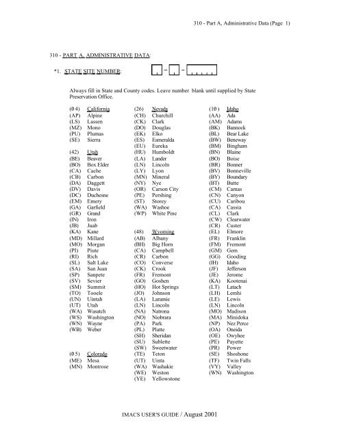
310 - Part A, Administrative Data (Page 1 ... - University of Utah
310 - Part A, Administrative Data (Page 1 ... - University of Utah
310 - Part A, Administrative Data (Page 1 ... - University of Utah

Create successful ePaper yourself
Turn your PDF publications into a flip-book with our unique Google optimized e-Paper software.
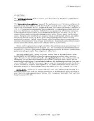
<strong>310</strong> - PART A, ADMINISTRATIVE DATA :<br />
*1.<br />
STATE SITE NUMBER :<br />
IMACS USER'S GUIDE / August 2001<br />
<strong>310</strong> - <strong>Part</strong> A, <strong>Administrative</strong> <strong>Data</strong> (<strong>Page</strong> 1)<br />
Always fill in State and County codes. Leave number blank until supplied by State<br />
Preservation Office.<br />
(0/ 4) California (26) Nevada (10/ ) Idaho<br />
(AP) Alpine (CH) Churchill (AA) Ada<br />
(LS) Lassen (CK) Clark (AM) Adams<br />
(MZ) Mono (DO) Douglas (BK) Bannock<br />
(PU) Plumas (EK) Elko (BL) Bear Lake<br />
(SE) Sierra (ES) Esmeralda (BW) Beneway<br />
(EU) Eureka (BM) Bingham<br />
(42) <strong>Utah</strong> (HU) Humboldt (BN) Blaine<br />
(BE) Beaver (LA) Lander (BO) Boise<br />
(BO) Box Elder (LN) Lincoln (BR) Bonner<br />
(CA) Cache (LY) Lyon (BV) Bonneville<br />
(CB) Carbon (MN) Mineral (BY) Boundary<br />
(DA) Daggett (NY) Nye (BT) Butte<br />
(DV) Davis (OR) Carson City (CM) Camas<br />
(DC) Duchesne (PE) Pershing (CN) Canyon<br />
(EM) Emery (ST) Storey (CU) Caribou<br />
(GA) Garfield (WA) Washoe (CA) Cassia<br />
(GR) Grand (WP) White Pine (CL) Clark<br />
(IN) Iron (CW) Clearwater<br />
(JB) Juab (CR) Custer<br />
(KA) Kane (48) Wyoming (EL) Elmore<br />
(MD) Millard (AB) Albany (FR) Franklin<br />
(MO) Morgan (BH) Big Horn (FM) Fremont<br />
(PI) Piute (CA) Campbell (GM) Gem<br />
(RI) Rich (CR) Carbon (GG) Gooding<br />
(SL) Salt Lake (CO) Converse (IH) Idaho<br />
(SA) San Juan (CK) Crook (JF) Jefferson<br />
(SP) Sanpete (FR) Fremont (JE) Jerome<br />
(SV) Sevier (GO) Goshen (KA) Kootenai<br />
(SM) Summit (HO) Hot Springs (LT) Latach<br />
(TO) Tooele (JO) Johnson (LH) Lemhi<br />
(UN) Uintah (LA) Laramie (LE) Lewis<br />
(UT) <strong>Utah</strong> (LN) Lincoln (LN) Lincoln<br />
(WA) Wasatch (NA) Natrona (MO) Madison<br />
(WS) Washington (NO) Niobrara (MA) Minidoka<br />
(WN) Wayne (PA) Park (NP) Nez Perce<br />
(WB) Weber (PL) Platte (OA) Oneida<br />
(SH) Sheridan (OE) Owyhee<br />
(SU) Sublette (PE) Payette<br />
(SW) Sweetwater (PR) Power<br />
(0/ 5) Colorado (TE) Teton (SE) Shoshone<br />
(ME) Mesa (UT) Uinta (TF) Twin Falls<br />
(MN) Montrose (WA) Washakie (VY) Valley<br />
(WE) Weston (WN) Washington<br />
(YE) Yellowstone
*2.<br />
IMACS USER'S GUIDE / August 2001<br />
<strong>310</strong> - <strong>Part</strong> A, <strong>Administrative</strong> <strong>Data</strong> (<strong>Page</strong> 2)<br />
AGENCY NUMBER : Nevada BLM and USFS sites only, as assigned by agency.<br />
Forest Codes : (Proclaimed Forest)<br />
Forest - Site Number<br />
or<br />
BLM Districts and<br />
Resource Area<br />
(AS) Ashley (DX) Dixie (SL) Salmon<br />
(BR) Bitteroot (FL) Fishlake (SW) Sawtooth<br />
(BS) Boise (HM) Humboldt (TG) Targhee<br />
(BT) Bridger-Teton (ML) Manti-LaSal (TY) Toiyabe<br />
(CB) Caribou (NP) Nez Perce (UN) Uinta<br />
(CH) Challis (PY) Payette (WS) Wasatch<br />
(BH) Bighorn (MB) Medicine Bow (SH) Shoshoni<br />
(BL) Black Hills (TB) Thunder Basin<br />
Nevada<br />
BLM District/Resource Area<br />
Elko<br />
Winnemucca<br />
(11) Wells (21) Paradise-Denio<br />
(12) Elko (22) Sonoma-Gerlach<br />
Carson City<br />
Ely<br />
(31) Lahontan (46) Egan<br />
(32) Walker (47) Schell<br />
Las Vegas<br />
Battle Mountain<br />
(51) Caliente (61) Tonopah<br />
(52) Virgin Valley (62) Shoshone<br />
(53) Stateline (63) Eureka<br />
(54) Esmeralda
3.<br />
4.<br />
5.<br />
*6.<br />
7.<br />
8.<br />
TEMP SITE NO .: Use this category for temporary site field numbers.<br />
STATE : Enter the name <strong>of</strong> the state in which the site is located.<br />
COUNTY : Enter the county.<br />
PROJECT : Enter the name <strong>of</strong> impacting project, if any.<br />
IMACS USER'S GUIDE / August 2001<br />
<strong>310</strong> - <strong>Part</strong> A, <strong>Administrative</strong> <strong>Data</strong> (<strong>Page</strong> 3)<br />
REPORT NUMBER . For USFS, Nevada BLM, each agency has its own number format<br />
but will use the same encoding block, as indicated below. In <strong>Utah</strong>, this entry is reserved<br />
for Project I.D.<br />
USFS:<br />
BLM:<br />
Forest/Year - Report No.<br />
Use the same Forest codes as shown in item A2.<br />
Ex: Boise NF, report #312, 1982 =<br />
District (hyphen) Report No.<br />
B S 8 2 0/ 3 1 2<br />
Use the same district codes as shown in item A2.<br />
Ex: Elko District, report #312 = 0/ 0/<br />
1 - 0/ 3 1 2<br />
SITE NAME/PROPERTY NAME : Enter any popular names or designations for this site, if any<br />
Property names are known historic property names, not current owner's names. Include<br />
references to any previous site publications or informants, if applicable. Enter the first 25<br />
characters, including blank spaces, into A35.<br />
CLASS : Check as appropriate. (Paleontological, Prehistoric, Historic Ethnographic).<br />
Many sites require that more than one class be checked.
9.<br />
*10/ .<br />
*11.<br />
SITE TYPE : Short description <strong>of</strong> site.<br />
IMACS USER'S GUIDE / August 2001<br />
<strong>310</strong> - <strong>Part</strong> A, <strong>Administrative</strong> <strong>Data</strong> (<strong>Page</strong> 4)<br />
ELEVATION : Record the elevation in feet as determined from the USGS topographical<br />
map (if available). Zero fill in all blanks and right justify.<br />
Example: 5600' = 0/ 5 6 0/ 0/<br />
UTM GRID : Using a USGS map and standard UTM calculator, locate the site's position<br />
within the Universal Transverse Mercator Grid System. For small sites, indicate the<br />
centerpoint only, for sites over 40/ acres or linear sites (trails, canals, etc.), enter multiple<br />
UTMs in item A36 <strong>of</strong> the site form and use multiple entries in part A11 <strong>of</strong> the encoding<br />
form. Enter up to 4 UTM locations, as appropriate. (Multiple entry <strong>of</strong> UTMs is optional.)<br />
CAUTION: ALL SPACES IN THE UTM ENCODING BLOCK MUST BE FILLED, OR YOU<br />
HAVE MADE AN ERROR. EASTINGS CONTAIN 6 CHARACTERS, NORTHINGS 7<br />
CHARACTERS. BE SURE UTM COORDINATES ARE ACCURATE.<br />
Procedure For Calculating UTMs<br />
1. Find your point on the map.<br />
2. With the straightedge, carefully draw a line from the top <strong>of</strong> the map to the bottom,<br />
connecting the two blue UTM ticks immediately west <strong>of</strong> the point. Make sure the<br />
ticks are a correct pair (have the same value).<br />
3. Do the same for the pair <strong>of</strong> ticks immediately south <strong>of</strong> the point; draw a line from the<br />
left to the right side <strong>of</strong> the map. This will intersect your first line somewhere to the<br />
southwest <strong>of</strong> the point (Figure 1).<br />
4. Record the UTM zone number.
IMACS USER'S GUIDE / August 2001<br />
<strong>310</strong> - <strong>Part</strong> A, <strong>Administrative</strong> <strong>Data</strong> (<strong>Page</strong> 5)<br />
Figure 1 - USGS map with lines drawn to connect UTM ticks. The<br />
lines intersect southwest <strong>of</strong> the point.
*12.<br />
IMACS USER'S GUIDE / August 2001<br />
<strong>310</strong> - <strong>Part</strong> A, <strong>Administrative</strong> <strong>Data</strong> (<strong>Page</strong> 6)<br />
5. Record the easting and northing values <strong>of</strong> the drawn lines. In our example (Fig. 4),<br />
this would be 640/ ___ m. E. and 4987___ m. N. (If this is unclear, refer to section<br />
485.) These are the first digits <strong>of</strong> your complete UTM location; the last three digits<br />
will be measured with the plastic UTM calculator.<br />
6. Find the scale on the UTM calculator which matches the scale on the bottom <strong>of</strong> your<br />
map. The two most common scales are 1:24,0/0/0/ (7.5 minute) and 1:62,50/0/ (15<br />
minute).<br />
7. Using the UTM calculator, measure how far east the point is from the north-south line<br />
you drew. Record this as the last three digits <strong>of</strong> the easting value. The point in Figure<br />
2 is 560/ meters east <strong>of</strong> the line. Thus, the complete easting value is 640/ 560 / m. E.<br />
8. Repeat the process, measuring from the point to the east-west line to obtain the<br />
complete northing value.<br />
Figure 2 - The UTM calculator shows that this point is 560/<br />
meters east <strong>of</strong> the line, or UTM 640/ 560/ m E.<br />
For more detailed instructions on how to calculate UTMs, refer to Section 485, UTM Instructions.<br />
TOWNSHIP AND RANGE 1: Locate the site to the nearest 10/ acre subdivision. If a site<br />
is large or straddles section or township lines, describe the situation in part A36 <strong>of</strong> the<br />
site form and use multiple entries in part A12 <strong>of</strong> the encoding sheet. For site locations,<br />
use the following procedure to standardize template use: 1) Anchor template on SE<br />
corner, 2). Alternative positioning is the NW corner. If the second positioning or any<br />
other positioning is used, please note on the site form how the location was determined.<br />
Enter up to 4 Township and Range locations, as appropriate. If the section is not the<br />
standard 640/ acre plot, divide the section into quarters based on its actual dimensions<br />
instead <strong>of</strong> using templates.<br />
Location codes for<br />
10, 40, & 160 acre<br />
subdivisions.<br />
Section Township<br />
Range
12a.<br />
*13.<br />
*14.<br />
15.<br />
Subdivision Codes<br />
(NE) Northeast<br />
(SE) Southeast<br />
(NW) Northwest<br />
(SW) Southwest<br />
(CT) Center<br />
Example A<br />
Example B<br />
Example C<br />
Example D<br />
IMACS USER'S GUIDE / August 2001<br />
<strong>310</strong> - <strong>Part</strong> A, <strong>Administrative</strong> <strong>Data</strong> (<strong>Page</strong> 7)<br />
Examples: T. 5N., R. 13 E., Section 6<br />
160 Acres<br />
40 Acres<br />
10 Acres<br />
(*Not to be used for 10 acre subdivisions)<br />
Half Township/Range<br />
S E S W N E 0/ 6 0/ 5 N 0/ 1 3 E<br />
C T<br />
C T<br />
N W<br />
S E S W<br />
0/<br />
0/<br />
0/<br />
6<br />
6<br />
6<br />
N W S W S E 0/ 6 0/ 5 5 N 0/ 1 3 5<br />
STREET/ADDRESS : Enter the street and address for Historic sites (where applicable).<br />
C T<br />
MERIDIAN : Enter the code for your base meridian.<br />
Meridian Codes: (1) SLC (<strong>Utah</strong>) (5) Wind River (Wyoming)<br />
(2) Uintah (<strong>Utah</strong>) (6) New Mexico 6th<br />
(3) Boise (Idaho) (7) Mt. Diablo (Nevada)<br />
(4) 6th Principal (8) San Bernadino (California)<br />
(Wyoming) (9) Willamette (Oregon)<br />
MAP REFERENCE : Record the name <strong>of</strong> the USGS map series (7.5' or 15') for the area<br />
where the site is located. In the case where no USGS maps are available, indicate the<br />
type <strong>of</strong> map used. For encoding, (USGS maps only) please enter the first 20/ characters <strong>of</strong><br />
the name <strong>of</strong> the USGS map. Leave a blank space between two words in the map name. If<br />
the map name exceeds 20/ characters in length, please truncate the entry after 20/ characters.<br />
If the map in question is one <strong>of</strong> a series (i.e., an old 15 minute map split into SE, NE, NW, SW<br />
Quadrats) and the map name exceeds 20/ characters, please enter the first 18 characters <strong>of</strong><br />
the map name and use the remaining 2 characters to identify the specific map (i.e., SE, NE,<br />
etc.). If site is on 2 USGS maps, enter the map containing the majority <strong>of</strong> the site. Enter the map<br />
name exactly as it is written on the map, including punctuation and spaces.<br />
AERIAL PHOTO DATA : When applicable, record the numerical designator, series, and<br />
date (if available) <strong>of</strong> aerial photos used to locate the site.<br />
0/<br />
0/<br />
0/<br />
5<br />
5<br />
5<br />
B.<br />
.<br />
D<br />
C<br />
N<br />
N<br />
N<br />
.<br />
0/<br />
0/<br />
0/<br />
.<br />
A<br />
1<br />
1<br />
1<br />
3<br />
3<br />
3<br />
E<br />
E<br />
E<br />
E
16.<br />
*17.<br />
*18.<br />
IMACS USER'S GUIDE / August 2001<br />
<strong>310</strong> - <strong>Part</strong> A, <strong>Administrative</strong> <strong>Data</strong> (<strong>Page</strong> 8)<br />
GENERAL LOCATION AND ACCESS : Describe the site location relative to local<br />
landforms and to prominent natural features (e.g., mountains, streams, cliffs, etc.), as well<br />
as cultural features (e.g., roads, towns, power lines, etc.). This description should be<br />
accurate enough to help a future surveyor relocate the site. Include road mile numbers<br />
and river mile numbers, if appropriate. Begin with a general reference to the area's most<br />
notable landmark; e.g., approximately 5 miles east <strong>of</strong> Jackson Hole. Then get more<br />
specific.<br />
LANDOWNER : Enter land ownership as it corresponds to Township and Range entry.<br />
For those large sites that span ownership boundaries, enter the predominant owner and<br />
describe the situation in A-36 on the encoding form.<br />
Owner Codes :<br />
(BR) Bureau <strong>of</strong> Rec. (IR) Indian Reservation (PR) Private<br />
(CI) City (LM)BLM (SE) Split Estate<br />
(CO) County (MR)Military Reservation (ST) State<br />
(FS) USFS (PS) Park Service (OT) Other<br />
(FW)Fish & Wildlife (ZZ) Unknown<br />
FEDERAL ADMINISTRATIVE UNITS : For all sites on USFS and BLM lands, fill in both<br />
encoding blocks. For NPS sites, fill in the first block only. Note that for the BLM "District"<br />
is a state subdivision; for the USFS, it is a Forest subdivision.<br />
U.S.F.S. Sites BLM Sites<br />
BLM District Codes:<br />
Forest District<br />
District Resource<br />
Area<br />
UTAH - BLM<br />
WYOMING - BLM<br />
IDAHO - BLM<br />
(B2) Salt Lake (W1) Rock Springs (BG) Boise District<br />
(B4) Cedar City (W2) Worland (BH) Burley<br />
(B5) Richfield (W3) Rawlins (BI) Idaho Falls<br />
(B6) Moab (W4) Casper (BJ) Salmon<br />
(B8) Vernal (BK) Shoshone<br />
(BL) Cottonwood<br />
(Res. Area Office)<br />
NEVADA - BLM<br />
(BA) Ely<br />
CALIFORNIA<br />
(BB) Elko (SU) Susanville<br />
(BC) Las Vegas<br />
(BD) Battle Mountain<br />
(BE) Winnemucca<br />
(BF) Carson City
*18.<br />
IMACS USER'S GUIDE / August 2001<br />
<strong>310</strong> - <strong>Part</strong> A, <strong>Administrative</strong> <strong>Data</strong> (<strong>Page</strong> 9)<br />
FEDERAL ADMINISTRATIVE UNITS (continued)<br />
BLM Resource Area Codes:<br />
IDAHO:<br />
Boise : Burley :<br />
Idaho Falls :<br />
(A6) Cascade (B5) Snake River (C6) Big Butte<br />
(A7) Owyhee (B9) Deep Creek (C7) Medicine Lodge<br />
(A8) Bruneau (C9) Pocatello<br />
(A9) Jarbidge<br />
Salmon :<br />
Shoshone :<br />
Coeur d'alene :<br />
(D6) Challis (E6) Monument (F6) Emerald Empire<br />
(D8) Lemhi (E7) Bennett Hills (F7) Cottonwood<br />
UTAH:<br />
Salt Lake :<br />
Cedar City :<br />
Richfield :<br />
(G6) Bear River (H6) Beaver River (I6) House Range<br />
(G7) Pony Express (H7) Dixie (I7) Warm Springs<br />
(H8) Kanab (I8) Sevier<br />
(H9) Escalante (I9) Henry Mountain<br />
Moab : Vernal :<br />
(J6) Price River (K6) Diamond Mountain<br />
(J7) San Rafael (K7) Book Cliffs<br />
(J8) Grand<br />
(J9) San Juan<br />
WYOMING:<br />
Worland :<br />
Rawlins :<br />
Rock Springs :<br />
(L1)Grass Creek (M1)Lander (N1)Pinedale<br />
(L2)Washakie (M2)Divide (N2)Kemmerer<br />
(L3)Cody<br />
Casper :<br />
(M3)Medicine Bow<br />
(M4)Great Divide<br />
(N3)Green River<br />
(P1) Buffalo<br />
(P2) Platte River<br />
(P3) Newcastle<br />
CALIFORNIA:<br />
Susanville :<br />
(Q1) Surprise<br />
(Q2) Eagle Lake<br />
(Q3) Alturas<br />
Forest Codes : (<strong>Administrative</strong> Forest)<br />
(0/ 1) Ashley (0/ 8) Fishlake (15) Targhee<br />
(0/ 2) Boise (0/ 9) Humboldt (17) Toiyabe<br />
(0/ 3) Bridger-Teton (10/ ) Manti-LaSal (18) Uinta<br />
(0/ 5) Caribou (12) Payette (19) Wasatch<br />
(0/ 6) Challis (13) Salmon (20/ ) Nezperce<br />
(0/ 7) Dixie (14) Sawtooth (21) Bitterroot<br />
(22) Bighorn<br />
(23) Medicine Bow<br />
(24) Shoshoni<br />
(25) Black Hills<br />
(26) Thunder Basin<br />
(27) Lake Tahoe
*18.<br />
FEDERAL ADMINISTRATIVE UNITS (continued)<br />
IMACS USER'S GUIDE / August 2001<br />
<strong>310</strong> - <strong>Part</strong> A, <strong>Administrative</strong> <strong>Data</strong> (<strong>Page</strong> 10)<br />
USFS District Codes :<br />
Ashley<br />
Boise<br />
Bridger-Teton<br />
(0/ 1) Flaming Gorge (0/ 5) Mountain Home (11) Kemmerer<br />
(0/ 2) Vernal (0/ 6) Boise (12) Big Piney<br />
(0/ 3) Roosevelt (0/ 7) Idaho City (13) Greys River<br />
(0/ 4) Duchesne (0/ 8) Cascade (14) Hoback<br />
Caribou (0/ 9) Lowman (15) Gros Ventre<br />
(17) Soda Springs (10/ ) Emmett (16) Buffalo<br />
(18) Montpelier<br />
Manti-LaSal (79) Pinedale<br />
(19) Malad (40) Sanpete<br />
Targhee<br />
(20/ ) Pocatello (41) Ferron (60/ ) Dubois<br />
Challis (42) Price (61) Island Park<br />
(21) Middle Fork (43) Moab (62) Ashton<br />
(22) Challis (44) Monticello (63) Palisades<br />
(23) Yankee Fork<br />
Payette (64) Teton Basin<br />
(24) Lost River (45) Council<br />
Toiyabe<br />
Dixie (46) Weiser (65) Carson<br />
(25) Pine Valley (47) New Meadows (66) Bridgeport<br />
(26) Cedar City (48) McCall (67) Austin<br />
(27) Powell (49) Big Creek (68) Tonopah<br />
(28) Escalante (50/ ) Krassel (69) Las Vegas<br />
(29) Teasdale<br />
Salmon<br />
Uinta<br />
Fishlake (51) Cobalt (70/ ) Heber<br />
(30/ ) Fillmore (52) North Fork (71) Pleasant Grove<br />
(31) Loa (53) Leadore (72) Spanish Fork<br />
(32) Beaver (54) Salmon<br />
Wasatch - Cache<br />
(33) Richfield<br />
Sawtooth (73) Salt Lake<br />
Humboldt (55) Burley (74) Kamas<br />
(34) Mountain City (56) Twin Falls (75) Evanston<br />
(35) Ruby Mountains (57) Ketchum (76) Mountain View<br />
(36) Jarbidge (58) Fairfield (77) Ogden<br />
(37) White Pine (59) Sawtooth NRA (78) Logan<br />
(38) Santa Rosa<br />
Nezperce<br />
(39) Ely (80/ ) Red River<br />
Bitterroot<br />
(81) West Fork<br />
USFS District Codes :<br />
Black Hills Medicine Bow<br />
Shoshoni<br />
(97) Bearlodge (87) Brush Creek (90/ ) Laramie Peak (92) Clarks Fork (95)Wapiti<br />
(98) Elk Mtn. (88) Hayden (91) Thunder Basin (93) Greybull (96) Wind River<br />
(99) Spearfish (89) Laramie (94) Lander<br />
Big Horn<br />
(82) Buffalo (83) Medicine Wheel (84) Paint Rock (86) Tongue (85) Tensleep<br />
National Park Service Park Codes :<br />
UTAH - NPS<br />
(AR) Arches (CB) Cedar Breaks (NB) Natural Bridges<br />
(BR) Bryce (DI) Dinosaur (TC) Timpanogos Cave<br />
(CA) Canyonlands (GL) Glen Canyon (XI) Zion<br />
(CR) Capitol Reef (GO) Golden Spike<br />
WYOMING - NPS
IMACS USER'S GUIDE / August 2001<br />
<strong>310</strong> - <strong>Part</strong> A, <strong>Administrative</strong> <strong>Data</strong> (<strong>Page</strong> 11)<br />
(DT) Devils Tower (FL) Fort Laramie (JR) John D. Rockefeller<br />
(FB) Fossil Butte (GT) Grand Teton (YE) Yellowstone
*18.<br />
FEDERAL ADMINISTRATIVE UNITS (continued)<br />
IMACS USER'S GUIDE / August 2001<br />
<strong>310</strong> - <strong>Part</strong> A, <strong>Administrative</strong> <strong>Data</strong> (<strong>Page</strong> 12)<br />
IDAHO - NPS<br />
NEVADA - NPS<br />
(CM) Craters <strong>of</strong> the Moon (GB) Great Basin National Park<br />
(LM) Lake Mead National Recreation Area<br />
19. LOCATION OF CURATED MATERIALS<br />
(AMH)American Museum <strong>of</strong> Natural History (MPC)Museum <strong>of</strong> Peoples & Cultures (BYU)<br />
(AHC)Anasazi Hertitage Center (NHS)Nevada Historical Society<br />
(ANP)Anasazi State Park (NMH)UNLV Museum <strong>of</strong> Natural History<br />
(AIP)Antelope Island State Park (NAT)Navajo Tribe<br />
(ASM)Arizona State Museum (NSM)Nevada State Museum<br />
(CFP)Camp Floyd State Park (NAU)Northern Arizona <strong>University</strong><br />
(CNP)Canyonlands National Park (PHM)Prehistoric Museum (College <strong>of</strong> E. <strong>Utah</strong>)<br />
(CCM)Churchill County Museum (PRM)John Wesley Powell River Museum<br />
(UCM)<strong>University</strong> <strong>of</strong> Colorado Museum (PTP)Pioneer Trail State Park<br />
(CPP)Coral Pink State Park (SCP)Snow Canyon State Park<br />
(DHP)Dead Horse Point State Park (SCR)Southwestern Cultural Resource Ctr.<br />
(DRI)Desert Research Institute, UNR (SMI)Smithsonian Institution<br />
(DLC)James Dickinson Lib. Spec. Collections, UNR (SNM)Southern Nevada State Mus. & Hist. Soc.<br />
(DNH)Dinosaur Natural History Museum (STC)Stillwater Crypt<br />
(ECM)Emery County Museum (SWM)Southwest Museum<br />
(ECP)Edge <strong>of</strong> the Cedars State Park (SUS)Southern <strong>Utah</strong> State College<br />
(ESP)Escalante State Park (TAM)A. Treganza Anthro. Mus., SF State Univ.<br />
(FBP)Fort Buenaventura State Park (TSP)Territorial State House State Park<br />
(FHP)<strong>Utah</strong> Field House State Park (UCD)UC Davis Dept. <strong>of</strong> Anthropology<br />
(FIP)Fremont Indian State Park (UCL)UCLA Dept. <strong>of</strong> Anthropology<br />
(GLC)Getchell Library Special Collections, UNR (UCR)UC Riverside Dept. <strong>of</strong> Anthropology<br />
(HFN)Heye Foundation, NYC (UFH) <strong>Utah</strong> Fieldhouse <strong>of</strong> Natural History<br />
(IHS)Idaho State Historical Society (UIM)Northern Idaho Regional Arch. Ctr.<br />
(IMP)Iron Mission State Park (ULK)<strong>University</strong> <strong>of</strong> Louisville<br />
(ISU)Southeastern Idaho Regional Arch. Ctr. (UMH)<strong>Utah</strong> Museum <strong>of</strong> Natural History<br />
(LCM)Lost City Museum State Park (UNM)Univ. <strong>of</strong> New Mexico(Lab. <strong>of</strong> Anthro.)<br />
(LMB)Lowie Museum, UC Berkeley (UNR)UNR Museum <strong>of</strong> Anthropology19.<br />
(MEC)Mesa College (USU)<strong>Utah</strong> State <strong>University</strong><br />
(MNP)Mesa Verde National Park (UWL)<strong>University</strong> <strong>of</strong> Wyoming, Laramie<br />
(MAC)Midwest Archaeological Center (WMP)Wasatch Mountain State Park<br />
(MOM)Moab Museum (Dan O'Laurie Museum) (WAS)Washington State <strong>University</strong><br />
(MNA)Museum <strong>of</strong> Northern Arizona (WSU)Weber State <strong>University</strong><br />
(WAC)Western Archaeological Center<br />
(WWC)West. Wyoming College, Rock Springs<br />
(ZNP) Zion National Park
20.<br />
*21.<br />
*22.<br />
IMACS USER'S GUIDE / August 2001<br />
<strong>310</strong> - <strong>Part</strong> A, <strong>Administrative</strong> <strong>Data</strong> (<strong>Page</strong> 13)<br />
SITE DESCRIPTION : Describe the site in detail and, if needed, continue the discussion<br />
on continuation sheets.<br />
SITE CONDITION :<br />
Codes :<br />
(A) Excellent - virtually undisturbed<br />
(B) Good - 75 percent undisturbed<br />
(C) Fair - 50/ -75 percent undisturbed<br />
(D) Poor - more than 50/ percent disturbed<br />
(E) Inundated - covered with water<br />
(F) Destroyed - no longer exists<br />
(Z) Unknown - no information available<br />
IMPACT AGENTS : Enter actual agents <strong>of</strong> impact only, not anticipated impacts. There is<br />
room for three impacts. Fill in the blocks from left to right.<br />
Impact Agent #1 #2 #3<br />
Codes :<br />
(AG) Agricultural Use (MA) Major Building Alteration (RC) Recreation Use<br />
(CE) Completed Excavation (MI) Minor Building Alteration (RD) Road<br />
(CL) Clear Cutting (MN) Mining (RE) Research Excavation<br />
(DE) Deflation (NO) No Impact (RO) Rodent Damage<br />
(DM) Demolition/Dismantling (NI) No Information (RV) Recreational Vehicle<br />
(ER) Erosion (OT) Other (SD) Structural Decay<br />
(GR) Grazing (PR) Development Project (VA) Vandalism<br />
*23. NATIONAL REGISTER STATUS :<br />
TO BE ENCODED BY PERMITTED ARCHAEOLOGISTS OR CERTIFIED CREW CHIEFS<br />
ONLY. Indicate the appropriate code and provide a statement to justify your recommendation. Make every<br />
possible effort to evaluate the site, but if a recommendation<br />
cannot be made, use undetermined (Z) rather than leaving it blank.<br />
23a.<br />
Codes:<br />
(A) National Register Listed Site (G) National Register Site but<br />
(B) Nominated for National Register no longer exists<br />
(C) National Register Quality (H) National Historic Landmark<br />
(Pr<strong>of</strong>essional Judgement) (I) Determined Eligible (SHPO concurrence)<br />
(D) Non-significant (Pr<strong>of</strong>essional (J) Determined Eligible, owner objection<br />
Judgement) (SHPO Concurrence)<br />
(E) Other (O) Other Register<br />
(F) Registered as part <strong>of</strong> National (Z) Undetermined<br />
Register District<br />
EVALUATION LEVEL : (management use only).
24.<br />
25.<br />
IMACS USER'S GUIDE / August 2001<br />
<strong>310</strong> - <strong>Part</strong> A, <strong>Administrative</strong> <strong>Data</strong> (<strong>Page</strong> 14)<br />
PHOTOGRAPH NUMBERS : Include the photo numbers in whatever system your survey<br />
organization uses. Indicate where your photo negative is stored.<br />
RECORDED BY : Record the name <strong>of</strong> the person(s) responsible for the site record.
*26.<br />
IMACS USER'S GUIDE / August 2001<br />
<strong>310</strong> - <strong>Part</strong> A, <strong>Administrative</strong> <strong>Data</strong> (<strong>Page</strong> 15)<br />
SURVEY ORGANIZATION : If your organization has no code, call the <strong>University</strong> <strong>of</strong> <strong>Utah</strong>,<br />
Archaeological Center (801) 581-8663.<br />
Survey Organization Codes<br />
(AA) J.P. Albanese<br />
(AB) Anthro Research, Inc.<br />
(AC) Am. Museum <strong>of</strong> Nat. His.<br />
(AD) Archeological Associates<br />
(AE) Arch. Research Assoc.<br />
(AF) Arch. Environ. Res. Corp.<br />
(AG) Archeological Rescue<br />
(AH) Arch. Services<br />
(AI) Arizona State Museum<br />
(AJ) Arizona State Park<br />
(AK) ARCON<br />
(AL) Ancient Enterprises, Inc.<br />
(AM) Archeological Consultants<br />
(AN) Archeo Consultants<br />
(AO) Archaeological Energy<br />
(AP) Argonne National Lab.<br />
(AQ) Arch. Consultants (Worland)<br />
(AR) Arch. Research Services<br />
(AS) Abajo Archaeology<br />
(AT) AR Consultants<br />
(AU) Antiquus<br />
(AV) Agency <strong>of</strong> Conserv. Arch.<br />
(AW) American Arch. Consultants<br />
(AX) Applied Archaeology Consult.<br />
(AY) An Independent Archaeologist<br />
(AZ) Anonymous<br />
(A1) Alpine Arch. Consult. Inc.<br />
(A2) Ancient America Foundation<br />
(A3) Archaeological Consulting Serv.<br />
(A4) Antonette Chambers Noble<br />
(A5) Advance Sciences, Inc.<br />
(A6) Archae. Res. <strong>of</strong> Southern Nevada<br />
(A7) Adams and Associates<br />
(BA) Basin Research<br />
(BB) Boise State <strong>University</strong><br />
(BC) Brigham Young <strong>University</strong><br />
(BD) Bristlecone, Inc.<br />
(BE) Bureau <strong>of</strong> Reclamation<br />
(BF) Burgess and Associates<br />
(BG) Burney & Associates<br />
(BH) Buffalo Bill Historical Center<br />
(BI) Bureau <strong>of</strong> Indian Affairs<br />
(BJ) James Brechtel<br />
(BL) BLM<br />
(BM) B.R. Butter, Assoc.<br />
(BN) Bighorn Basin Consulting<br />
(BO) B.C. Services<br />
(BR) Basin and Range Research<br />
(CA) U <strong>of</strong> Calif., Berkeley<br />
(CB) U <strong>of</strong> Calif., Davis<br />
(CC) U <strong>of</strong> Calif., L.A.<br />
(CD) Centuries Research<br />
(CE) Chambers Group, Inc<br />
(CF) Colorado State Univ.<br />
(CG) State <strong>of</strong> Colorado<br />
(CH) Complete Archaeology<br />
(CI) Cult. Res. Consultants<br />
(CJ) <strong>University</strong> <strong>of</strong> Colorado<br />
(CK) Cal. State College<br />
(CL) Chambers Group, Inc.<br />
(CM) Univ. <strong>of</strong> N. Colorado<br />
(CN) Centennial Archeology<br />
(CO) Cent. Washington Arch. Surv.<br />
(CP) Cultural Reserch/Management<br />
(CQ) Fred Chapman<br />
(CR) Crouch, J.R.<br />
(CS) Crow Canyon Center For<br />
Southwestern Arch.<br />
(CT) College <strong>of</strong> Eastern <strong>Utah</strong><br />
(CU) Cultural Resource Group<br />
(CV) D. & J. Chance & Associates<br />
(CX) U <strong>of</strong> Cal., Riverside<br />
(DA) Desert Research Instit.<br />
(DB) Div. <strong>of</strong> Conserv. Arch.<br />
(DC) Denver <strong>University</strong><br />
(DD) Dept. <strong>of</strong> Env. Quality<br />
(DE) David Darlington<br />
(DF) Desert West<br />
(DG) Dakota Research Services<br />
(DH) Dames & Moore<br />
(DI) Mary Dohnalek<br />
(DJ) D. L Zurga and Associates<br />
(DK) William C. Davis<br />
(DL) Daggett & Chenault Inc.<br />
(EA) Eastern New Mexico Univ.<br />
(EB) Eastern Washington Univ.<br />
(EC) Environmental Consultants<br />
(ED) ESCA Tech<br />
(EE) Environ. Res. Cntr. (DAS)<br />
(EF) Ethnoscience<br />
(EG) Environ. Studies Group<br />
(EH) Ecosystems Resources, Inc (ERI)<br />
(EI) Environmental Solutions Inc.<br />
(EJ) Ebasco Environmental<br />
(FA) Frontier Archeology<br />
(FB) Fugro Northwest (ERTEC)<br />
(FC) Flat Irons<br />
(FD) Ft. Lewis<br />
(FE) 4 Corners Archaeology<br />
(FF) Far Western Anthropo. Res. Grp.<br />
(FS) Forest Service<br />
(FW) Stillwater Nat'l Wildlife Refuge<br />
(GA) Gordon & Kranzush<br />
(GB) Grand River (Inst.)<br />
(GC) Grand River (Consult.)<br />
(GD) Gilbert/Commonwealth<br />
(GE) J. & M. Greer Arch. Cons.<br />
(GF) Goodson & Associates
*26. SURVEY ORGANIZATION: continued.<br />
(GG) GCM Services<br />
(GH) Great Basin National Park<br />
(HA) Harvard <strong>University</strong><br />
(HB) High Plains<br />
(HC) Heritage Museum<br />
(HD) Historical Research Assoc.<br />
(HE) Richard R. Harrison<br />
(HF) Marvin Hoyt<br />
(HG) Huerfano Consultants, Inc.<br />
(HH) Heritage Research Ctr.<br />
(IA) Idaho Arch. Consultants<br />
(IB) Idaho St. Highway Dept.<br />
(IC) Idaho St. Hist. Society<br />
(ID) Idaho St. <strong>University</strong><br />
(IE) Univ. <strong>of</strong> Idaho<br />
(IF) Intermountain Research<br />
(IG) Internat'l. Learning & Res.<br />
(IH) Independ. Arch. Consult.<br />
(II) Independent Archaeology<br />
(IJ) Intermontane Arch. Assoc.<br />
(IK) Idaho Museum <strong>of</strong> Nat. Hist.(IL)<br />
Intermountain Resources<br />
(IM) Independant Arch. Consultant<br />
(IN) Idaho Power Company<br />
(IR) Infotec Research, Inc.<br />
(JF) Frank W. Johnson<br />
(KA) K.K. Pelli<br />
(KB) Kantner-Smith<br />
(KC) Peter Kiewit Sons<br />
(KD) Kainer-Rodriquez Assoc.<br />
(KE) Kail Consulting Ltd.<br />
(KF) R. Kautz & Associates, Inc.<br />
(KG) Knight & Leavitt Assoc. Inc.<br />
(LA) La Plata Archaeological Consult.<br />
(LB) Laramie Cult. Research<br />
(LC) Llano Consultants<br />
(LD) Lincoln Land Comm. College<br />
(LE) Land Resources Technology<br />
(MA) Metcalf-Zier Arch., Inc.<br />
(MB) MESA<br />
(MC) Mike Moen & Associates<br />
(MD) Montgomery Engineers<br />
(ME) Mariah Associates<br />
(MF) Minerals Research Center<br />
(MG) Douglas McKay<br />
(MH) Montana State Univ.<br />
(MI) Univ. <strong>of</strong> Montana<br />
(MJ) Office <strong>of</strong> Surface Mining<br />
(MK) Univ. <strong>of</strong> Missouri<br />
(ML) Susan J. Miller<br />
(MM) Metcalf Arch. Consultants<br />
(MN) Middlefork Archaeology<br />
(MO) Moore Anthropological Research<br />
IMACS USER'S GUIDE / June 1992<br />
<strong>310</strong> - <strong>Part</strong> A, <strong>Administrative</strong> <strong>Data</strong> (<strong>Page</strong> 16)<br />
(NA) National Park Service<br />
(NB) Nevada Arch. Survey<br />
(NC) U <strong>of</strong> Nevada, Las Vegas<br />
(ND) U <strong>of</strong> Nevada, Reno<br />
(NE) Nevada State Museum<br />
(NF) New Mexico State Univ.<br />
(NG) New World Research<br />
(NH) Nickens & Associates<br />
(NI) Museum <strong>of</strong> N. Arizona<br />
(NJ) Northland Anthro. Res.<br />
(NK) Navajo Nation Cult. Res.<br />
(NL) Nevada Dept. <strong>of</strong> Trans.<br />
(NM) Native Cult.. Serv.<br />
(NN) Univ. <strong>of</strong> Northern Colorado<br />
(NO) Northern Arizona Univ.<br />
(NP) A.K. Nielson & Assoc.<br />
(NQ) Native Cultural Resource Serv.<br />
(NR) Northwest Arch. Assoc., Inc.<br />
(NS) National Spec. Soc.<br />
(NT) Univ. <strong>of</strong> Nebraska<br />
(NU) UNDAR-West (U. <strong>of</strong> N. Dakota)<br />
(NV) North Platt Arch. Services<br />
(NW) Niwot Archaeological Con.<br />
(OA) Oil Well Elev. & Loc.<br />
(OB) Overland Archeology, Inc.<br />
(PA) Powers Elevation<br />
(PB) Pr<strong>of</strong>essional Analysts<br />
(PC) Private Contractor or<br />
Engineering Company<br />
(PD) P-III Associates<br />
(PE) Pioneer Arch. Consult.<br />
(PF) Private Individual<br />
(PG) Pronghorn Anthro. Assoc.<br />
(PH) Paleo-Environmental<br />
(PI) P/S Scientific<br />
(PJ) Peak and Associates<br />
(PK) Plano Arch. Consultants<br />
(PL) Powder River Consultants<br />
(PM) Barry Price<br />
(PN) Patrick Engineering<br />
(PO) Petrographics<br />
(PP) <strong>University</strong> <strong>of</strong> Pittsburg<br />
(PR) Pleatau Resources<br />
(RA) Mary P. Rossillon<br />
(RB) Rocky Mt. Arch. Consult.<br />
(RC) Charles Reher<br />
(RD) Rosenberg Historical Consultants<br />
(RE) Univ. Of Redlands<br />
(RF) Resource Concepts, Inc.<br />
(RG) Research Archaeology<br />
(RH) R.K. Vierra & Assoc. Inc.<br />
(RT) Renewable Technologies<br />
(RW) Amer. Indian Rockwriting
*26. SURVEY ORGANIZATION: continued.<br />
(SA) San Juan Arch. Res. Cntr.<br />
(SB) Science Applications<br />
(SC) Senco-Phoenix<br />
(SD) Smithsonian Institution<br />
(SE) Southern <strong>Utah</strong> St. College<br />
(SF) Snake River Arch./Hist.<br />
(SG) San Jose State College<br />
(SH) Soil Conservation<br />
(SI) Soils System Inc.<br />
(SJ) Sagebrush Arch. Consult.<br />
(SK) Swanson and Associates<br />
(SL) San Juan College Cult. Res.<br />
Management Program<br />
(SM) Somona State <strong>University</strong><br />
(SN) J.F. Sato<br />
(SO) Noel Logan, SEC Inc.<br />
(SP) Southern Illinois <strong>University</strong><br />
(SQ) William Self & Associates<br />
(SR) Statistical Research<br />
(SS) Science Application Int. Corp.<br />
(SU) Southern Methodist U.<br />
(TA) Tennessee Valley Authr.<br />
(TB) Larson Tibesar<br />
(TC) Pat Treat<br />
(TD) Tetra Tech<br />
(TE) Tooele Army Depot<br />
(UA) <strong>University</strong> <strong>of</strong> <strong>Utah</strong><br />
(UB) <strong>Utah</strong> Arch. Research Corp.<br />
(UC) <strong>Utah</strong> St. Hist. Society<br />
(UD) <strong>Utah</strong> State Parks<br />
(UE) USGS<br />
(UF) U.S. Army Corp. <strong>of</strong> Engineers<br />
(UG) URS-Berger<br />
(UH) <strong>Utah</strong> Rock Art Assoc.<br />
(UI) U.R.S. Corp.<br />
(UJ) <strong>Utah</strong> State <strong>University</strong><br />
(UK) U.S. Fish and Wildlife<br />
(UL) <strong>Utah</strong> Div. <strong>of</strong> Oil Gas & Mining<br />
(UM) <strong>Utah</strong> Div. <strong>of</strong> State Lands/Forestry<br />
(US) <strong>Utah</strong> Statewide Archaeolog. Soc.<br />
(WA) Univ. <strong>of</strong> Washington<br />
(WB) Washington St. <strong>University</strong><br />
(WC) Weber State College<br />
(WD) Westec Services, Inc.<br />
(WE) Western Cultural Res.<br />
(WF) Western Historical Studies<br />
(WG) Woodward-Clyde<br />
(WH) <strong>University</strong> <strong>of</strong> Wyoming<br />
(WI) Wyoming Office State Arch.<br />
(WJ) Worldwide Surveys<br />
(WK) Western Wyoming College<br />
(WL) Western Research<br />
(WM) Western Arch. Consultants<br />
IMACS USER'S GUIDE / June 1992<br />
<strong>310</strong> - <strong>Part</strong> A, <strong>Administrative</strong> <strong>Data</strong> (<strong>Page</strong> 17)<br />
(WN) Woods Canyon Arch. Consult.<br />
(WO) Water and Power Resources<br />
(WP) Wyoming Arch. Society<br />
(WQ) Wyoming Rec. Commission<br />
(WR) Western Heritage Conserv.<br />
(WS) Western Interp. Services<br />
(WT) W.G. Consultants<br />
(WU) White Mesa Institute (CEU)<br />
(WV) Western Prehist. Research<br />
(WW) Western Public Hist.. Assoc.<br />
(WX) West. Public Hist. Consortium<br />
(ZA) George Zeimens
27.<br />
28.<br />
*29.<br />
*30.<br />
ASSISTING CREW MEMBERS : List names <strong>of</strong> assisting archeologists.<br />
DATE OF SURVEY : Enter the date you recorded or re-visited the site.<br />
Month Day Year<br />
IMACS USER'S GUIDE/June 1992<br />
<strong>310</strong> - <strong>Part</strong> A, <strong>Administrative</strong> <strong>Data</strong> (<strong>Page</strong> 18)<br />
SLOPE : Enter the approximate degree (from horizontal) <strong>of</strong> slope and the downward<br />
direction <strong>of</strong> the slope (or aspect.) If the site is absolutely level, indicate that there is no<br />
slope. The slope <strong>of</strong> sites on ridge crests should be recorded according to the slope<br />
down that ridge crest. The slope <strong>of</strong> sites on the sides <strong>of</strong> ridges should be recorded<br />
according to the downward slope <strong>of</strong> that side. Use the code 98 for a complex slope. Use<br />
0/ for a north aspect, and 998 for no aspect.<br />
Slope Aspect<br />
(Degrees)<br />
W<br />
270°<br />
0°<br />
N<br />
S<br />
180°<br />
E<br />
90°<br />
DISTANCE TO WATER : Identify the nearest permanent natural water source. Refer to a<br />
USGS map if necessary. Record the distance to the nearest 10/0/ meters, type <strong>of</strong><br />
water, and name, if known.<br />
If the site is on the water, use 0/ , if between 0/ and 10/0/ meters use 1<br />
Distance<br />
(Meters X 100)<br />
Type<br />
<strong>of</strong><br />
Water<br />
Example: Stream 1475 meters from site = 0/ 1 5 B<br />
Codes: Unknown(999) (999) (Z) or leave blank<br />
On-site (998) - -<br />
Spring/seep - - (A)<br />
Stream/river - - (B)<br />
Lake - - (C)<br />
*Other - - (D)
*31.<br />
IMACS USER'S GUIDE/June 1992<br />
<strong>310</strong> - <strong>Part</strong> A, <strong>Administrative</strong> <strong>Data</strong> (<strong>Page</strong> 19)<br />
GEOGRAPHIC UNIT : For the codes in Nevada refer to the map <strong>of</strong> Static Ground Water<br />
Levels <strong>of</strong> Nevada, Division <strong>of</strong> Water Resources, State Engineers Office, 1974.<br />
Geographic Unit Codes for Nevada: (Please note that all <strong>of</strong> Nevada is in the Basin and<br />
Range Province)<br />
NORTHWEST REGION<br />
(BFA) Pueblo Valley (BFI) Long Valley<br />
(BFB) Continental Lake Valley (BFJ) Macy Flat<br />
(BFC) Gridley Lake Valley (BFK) Coleman Valley<br />
(BFD) Virgin Valley (BFL) Mosquito Valley<br />
(BFE) Sage Hen Valley (BFM) Warner Valley<br />
(BFF) Guano Valley (BFN) Surprise Valley<br />
(BFG) Swan Lake Valley (BFO) Boulder Valley<br />
(BFH) Massacre Lake Valley (BFP) Duck Lake Valley<br />
BLACK ROCK DESERT REGION<br />
(BGA) Pilgrim Flat (BGM) Pine Forest Valley<br />
(BGB) Painter Flat (BGN) King River Valley:<br />
(BGC) Dry Valley Rio King Subarea<br />
(BGD) Sano Valley (BGO) Kings River Valley:<br />
(BGE) Smoke Creek Desert Sod House Subarea<br />
(BGF) San Emidio Desert (BGP) Desert Valley<br />
(BGG) Granite Basin (BGQ) Silver State Valley<br />
(BGH) Hualapai Flat (BGR) Quinn River Valley:<br />
(BGI) High Rock Lake Valley Orovada Subarea<br />
(BGJ) Mud Meadow (BGS) Quinn River Valley:<br />
(BGK) Summit Lake Valley McDermitt Subarea<br />
(BGL) Black Rock Desert<br />
SNAKE RIVER BASIN<br />
(BHA) Little Owyhee River Area (BHE) Bruneau River Area<br />
(BHB) South Fork Owyhee River (BHF) Jarbridge River Area<br />
Area (BHG) Salmon Falls Creek Area<br />
(BHC) Independence Valley (BHH) Goose Creek Area<br />
(BHD) Owyhee River Area<br />
HUMBOLDT RIVER BASIN I<br />
(BIA) Marys River Area (BIL) Pine Valley<br />
(BIB) Starr Valley Area (BIM) Crescent Valley<br />
(BIC) North Fork Area (BIN) Carico Lake Valley<br />
(BID) Lamoille Valley (BIO) Upper Reese River Valley<br />
(BIE) South Fork Area (BIP) Antelope Valley<br />
(BIF) Huntington Valley (BIQ) Middle Reese River Valley<br />
(BIG) Dixie Creek-Tenmile (BIR) Lower Reese River Area<br />
Creek Area (BIS) Whirlwind Valley<br />
(BIH) Elko Segment (BIT) Boulder Flat<br />
(BII) Susie Creek Area (BIU) Rock Creek Valley<br />
(BIJ) Maggie Creek Area (BIV) Willow Creek Valley<br />
(BIK) Marys Creek Area (BIW) Clovers Area
*31.<br />
GEOGRAPHIC UNIT (continued, Nevada)<br />
HUMBOLDT RIVER AREA II<br />
(BJA) Pumpernickel Valley (BJG) Grass Valley<br />
(BJB) Kelly Creek Area (BJH) Imlay Area<br />
(BJC) Little Humboldt Valley (BJI) Lovelock Valley<br />
(BJD) Hardscrabble Area (BJJ) Lovelock Valley:<br />
(BJE) Paradise Valley Oreana Subarea<br />
(BJF) Winnemucca Segment (BJK) White Plains<br />
IMACS USER'S GUIDE/June 1992<br />
<strong>310</strong> - <strong>Part</strong> A, <strong>Administrative</strong> <strong>Data</strong> (<strong>Page</strong> 20)<br />
WEST CENTRAL REGION<br />
(BKA) Bradys Hot Springs Area (BKD) Granite Springs Valley<br />
(BKB) Fernley Area (BKE) Kumiva Valley<br />
(BKC) Fireball Valley<br />
TRUCKEE RIVER BASIN<br />
(BLA) Winnemucca Lake Valley (BLG) Sun Valley<br />
(BLB) Pyramid Lake Valley (BLH) Truckee Meadows<br />
(BLC) Dodge Flat (BLI) Pleasant Valley<br />
(BLD) Tracy Segment (BLJ) Washoe Valley<br />
(BLE) Warm Springs Valley (BLK) Lake Tahoe Basin<br />
(BLF) Spanish Springs Valley (BLL) Truckee Canyon Segment<br />
WESTERN REGION<br />
(BMA)Lemmon Valley: (BMF) Newcomb Lake Valley<br />
Western <strong>Part</strong> (BMG) Honey Lake Valley<br />
(BMB) Lemmon Valley: (BMH) Skedaddle Creek Valley<br />
Eastern <strong>Part</strong> (BMI) Red Rock Valley<br />
(BMC) Antelope Valley (BMJ) Cold Spring Valley<br />
(BMD) Bedell Flat (BMK) Long Valley<br />
(BME) Dry Valley<br />
CARSON RIVER BASIN<br />
(BNA) Carson Desert (BND) Dayton Valley<br />
(BNB) Carson Desert: (BNE) Eagle Valley<br />
Packard Valle (BNF) Carson Valley<br />
(BNC) Churchill Valley (BNG) Lahontan Valley<br />
WALKER RIVER BASIN<br />
(BOA) Antelope Valley (BOF) Walker Lake Valley:<br />
(BOB) Smith Valley Lake Subarea<br />
(BOC) Mason Valley (BOG) Walker Lake Valley:<br />
(BOD) East Walter Area Whiskey Flat -<br />
(BOE) Walker Lake Valley:<br />
Schurz Subarea<br />
Hawthorne Subarea<br />
CENTRAL REGION I<br />
(BPA) Alkali Valley (Mineral): (BPM) Soda Spring Valley:<br />
Northern <strong>Part</strong> Western <strong>Part</strong><br />
(BPB) Alkali Valley (Mineral): (BPN) Gabbs Valley<br />
Southern <strong>Part</strong> (BPO) Rawhide Flats<br />
(BPC) Mono Valley (BPP) Fairview Valley<br />
(BPD) Huntoon Valley (BPQ) Stingaree Valley<br />
(BPE) Teels Marsh Valley (BPR) Cowkick Valley<br />
(BPF) Adobe Valley (BPS) Eastgate Valley Area<br />
(BPG) Queen Valley (BPT) Dixie Valley
*31.<br />
GEOGRAPHIC UNIT (continued, Nevada)<br />
(BPH) Fish Lake Valley (BPU) Buena Vista Valley<br />
(BPI) Colombus Salt Marsh Valley (BPV) Pleasant Valley<br />
(BPJ) Rhodes Salt Marsh Valley (BPW) Buffalo Valley<br />
(BPK) Garfield Flat (BPX) Jersey Valley<br />
(BPL) Soda Spring Valley: (BPY) Edwards Creek Valley<br />
Eastern <strong>Part</strong> (BP1) Bodie-Aurora Uplands<br />
IMACS USER'S GUIDE/June 1992<br />
<strong>310</strong> - <strong>Part</strong> A, <strong>Administrative</strong> <strong>Data</strong> (<strong>Page</strong> 21)<br />
CENTRAL REGION II<br />
(BQA) Smith Creek (BQM) Lida Valley<br />
(BQB Lone Valley (BQN) Stonewall Flat<br />
(BQC) Monte Cristo Valley (BQO) Sarcobatus Flat<br />
(BQD) Big Smoky Valley: (BQP) Gold Flat<br />
Tonopah Flat (BQQ) Cactus Flat<br />
(BQE) Big Smoky Valley: (BQR) Stone Cabin Valley<br />
Northern <strong>Part</strong> (BQS) Little Fish Lake Valley<br />
(BQF) Grass Valley (BQT) Antelope Valley<br />
(BQG) Kobeh Valley (Eureka & Nye)<br />
(BQH) Monitor Valley: (BQU) Stevens Basin<br />
Northern <strong>Part</strong> (BQV) Diamond Valley<br />
(BQI) Monitor Valley: (BQW) Newark Valley<br />
Southern <strong>Part</strong> (BQX) Little Smoky Valley:<br />
(BQJ) Ralston Valley Northern <strong>Part</strong><br />
(BQK) Alkali Spring Valley (BQY) Little Smoky Valley:<br />
(Esmeralda) Central <strong>Part</strong><br />
(BQL) Clayton Valley<br />
CENTRAL REGION III<br />
(BRA) Little Smoky Valley: (BRM) Jean Lake Valley<br />
Southern <strong>Part</strong> (BRN) Hidden Valley (South)<br />
(BRB) Hot Creek (BRO) Eldorado Valley<br />
(BRC) Kawich Valley (BRP) Three Lakes Valley<br />
(BRD) Emigrant Valley: (Northern <strong>Part</strong>)<br />
Groom Lake Valley (BRQ) Tikapoo Valley:<br />
(BRE) Emigrant Valley: Northern <strong>Part</strong><br />
Papoose Lake Valley (BRR) Tikapoo Valley:<br />
(BRF) Yucca Flat Southern <strong>Part</strong><br />
(BRG) Frenchman Flat (BRS) Penoyer Valley<br />
(BRH) Indian Springs Valley (Sand Spring)<br />
(BRI) Pahrump Valley (BRT) Coal Valley<br />
(BRJ) Mesquite Valley (BRU) Garden Valley<br />
(Sandy Valley) (BRV) Railroad Valley:<br />
(BRK) Ivanpah Valley: Southern <strong>Part</strong><br />
Southern <strong>Part</strong> (BRW) Railroad Valley:<br />
(BRL) Ivanpah Valley:<br />
Northern <strong>Part</strong><br />
Northern <strong>Part</strong>
*31.<br />
GEOGRAPHIC UNIT (continued, Nevada)<br />
CENTRAL REGION IV<br />
(BSA) Jakes Valley (BSK) Lake Valley<br />
(BSB) Long Valley (BSL) Spring Valley<br />
(BSC) Ruby Valley (BSM) Tippett Valley<br />
(BSD) Clover Valley (BSN) Antelope Valley<br />
(BSE) Butte Valley: (White Pine & Elko)<br />
Northern <strong>Part</strong> Southern <strong>Part</strong><br />
(BSF) Butte Valley: (BSO) Antelope Valley<br />
Southern <strong>Part</strong> (White Pine & Elko)<br />
(BSG) Steptoe Valley Northern <strong>Part</strong><br />
(BSH) Cave Valley (BSP) Goshute Valley<br />
(BSI) Dry Lake Valley (BSQ) Independence Valley<br />
(BSJ) Delamar Valley (Pequop Valley)<br />
IMACS USER'S GUIDE/June 1992<br />
<strong>310</strong> - <strong>Part</strong> A, <strong>Administrative</strong> <strong>Data</strong> (<strong>Page</strong> 22)<br />
GREAT SALT LAKE BASIN<br />
(BTA) Thousand Springs Valley: (BTE) Grouse Creek Valley<br />
Herrill Siding - (BTF) Pilot Creek Valley<br />
Brush Creek Area (BTG) Great Salt Lake Desert<br />
(BTB) Thousand Spring Valley: (BTH) Deep Creek Valley<br />
Toano-Rock Spring Area (BTI) Pleasant Valley<br />
(BTC) Thousand Spring Valley: (BTJ) Snake Valley<br />
Rocky Butte Area (BTK) Hamlin Valley<br />
(BTD) Thousand Spring Valley:<br />
Montello-Crittenden<br />
Creek Area<br />
ESCALANTE DESERT<br />
(BUA) Escalante Desert<br />
COLORADO RIVER BASIN<br />
(BVA) Dry Valley (BVN) Three Lakes Valley<br />
(BVB) Rose Valley (Southern <strong>Part</strong>)<br />
(BVC) Eagle Valley (BVO) Las Vegas Valley<br />
(BVD) Spring Valley (BVP) Colorado Valley<br />
(BVE) Paterson Valley (BVQ) Piute Valley<br />
(BVF) Panaca Valley (BVR) Black Mountains Area<br />
(BVG) Clover Valley (BVS) Garnet Valley<br />
(BVH) Lower Meadow Valley Wash (BVT) Hidden Valley (North)<br />
(BVI) Kane Springs Valley (BVU) California Wash<br />
(BVJ) White River Valley (BVV) Muddy River Springs Area<br />
(BVK) Pahroc Valley (Upper Moapa Valley)<br />
(BVL) Pahranagat Valley (BVW) Lower Moapa Valley<br />
(BVM) Coyote Spring Valley<br />
COLORADO RIVER BASIN II<br />
(BWA) Tule Desert (BWC) Gold Butte Area<br />
(BWB) Virgin River Valley (BWD) Greasewood Basin
*31.<br />
GEOGRAPHIC UNIT (continued, Nevada)<br />
DEATH VALLEY BASIN<br />
(BXA) Mercury Valley (BXE) Oasis Valley<br />
(BXB) Rock Valley (BXF) Crater Flat<br />
(BXC) Fortymile Canyon: (BXG) Amargosa Desert<br />
Jackass Flats (BXH) Grapevine Canyon<br />
(BXD) Fortymile Canyon:<br />
Buckboard Mesa<br />
(BXI) Oriental Wash<br />
IMACS USER'S GUIDE/June 1992<br />
<strong>310</strong> - <strong>Part</strong> A, <strong>Administrative</strong> <strong>Data</strong> (<strong>Page</strong> 23)
*31.<br />
IMACS USER'S GUIDE/June 1992<br />
<strong>310</strong> - <strong>Part</strong> A, <strong>Administrative</strong> <strong>Data</strong> (<strong>Page</strong> 24)<br />
GEOGRAPHIC UNIT : For the codes in Idaho, refer to the map contained in Section 435.<br />
Geographic Unit<br />
Codes for Idaho :<br />
MIDDLE ROCKY MOUNTAINS<br />
(R0/ A) Bear Lake Plateau (R0/ I) Northern Blackfoot Mts.<br />
(R0/ B) Bear Lake Valley (R0/ J) Caribou Range<br />
(R0/ C) Eastern Wasatch Range (R0/ K) Upper Snake River/<br />
(R0/ D) Western Wasatch Range Swan Valley<br />
(R0/ E) Soda Springs Valley (R0/ L) Snake River Range<br />
(R0/ F) Western Aspen Range (R0/ M) Big Hole Mts.<br />
(R0/ G) Schmid/Webster Range (R0/ N) Upper Teton/Falls River<br />
(R0/ H) Willow Creek/Grays Lake (R0/ O) Island Park<br />
BASIN AND RANGE<br />
(B1A) Cache Valley (B1S) Western Blue Spring Hills<br />
(B1B) Eastern Malad Range (B1T) Pocatello Valley<br />
(B1C) So. Portneuf/Cottonwood Cr. (B1U) Curlew Valley<br />
(B1D) Southwest Portneuf Mts. (B1V) Arbon Valley<br />
(B1E) Southeast Portneuf Mts. (B1W) Eastern Deep Creek Mts.<br />
(B1F) Gem Valley (B1X) Southeast Deep Creek Mts.<br />
(B1G) Portneuf Valley (B1Y) Western Deep Creek Mts.<br />
(B1H) Northeast Portneuf Mts. (B2A) Rockland Valley<br />
(B1I) Northwest Portneuf Mts. (B2B) Eastern Sublette Mts.<br />
(B1J) Chesterfield (B2C) Western Sublette Mts.<br />
(B1K) Blackfoot River Valley (B2D) Southwest Sublette Mts.<br />
(B1L) Putnam Peak/Yandell Mts. (B2E) Curlew Grasslands<br />
(B1M) Northeast Bannock Mts (B2F) Eastern Black Pine Peak<br />
(B1N) Northwest Bannock Mts. (B2G) Western Black Pine Peak<br />
(B1O) Southwest Bannock Mts. (B2H) Raft River Valley<br />
(B1P) Western Malad Range (B2I) Eastern Albion Hills<br />
(B1Q) Malad Valley (B2J) Western Albion Hills<br />
(B1R) Eastern Blue Spring Hills (B2K) Junction Creek<br />
(B2L) Lower Portneuf/Marsh<br />
NORTHERN ROCKY MOUNTAINS<br />
(N3A) Medicine Lodge Mountains (N3O) Northwest Lost River Range<br />
(N3B) Southern Beaverhead Mts. (Western Pahsimeroi)<br />
(N3C) Beaverhead Mountains (N3P) Big Lost River Valley<br />
(N3D) Birch Creek Valley (N3Q) Challis/Round Valley<br />
(N3E) Lemhi Valley (N3R) White Knob Mountains<br />
(N3F) Southeast Lemhi Range (N3S) East Fork Salmon River<br />
(N3G) Southwest Lemhi Range (N3T) Eastern Lone Pine Peak<br />
(N3H) Northeast Lemhi Range (N3U) Challis Mountains<br />
(N3I) Northwest Lemhi Range (N3V) Iron Creek/Baldy Mt.<br />
(N3J) Little Lost River Valley (N3W) Panther Creek<br />
(N3K) Pahsimeroi (N3X) Shoup/Ulysses<br />
(N3L) Southeast Lost River Range (N3Y) Middle Fork Salmon Drainage<br />
(N3M) Southwest Lost River Range<br />
(N3N) Northeast Lost River Range<br />
(Eastern Pahsimeroi)
*31.<br />
GEOGRAPHIC UNIT (continued, Idaho)<br />
NORTHERN ROCKY<br />
MOUNTAINS (continued)<br />
IMACS USER'S GUIDE/June 1992<br />
<strong>310</strong> - <strong>Part</strong> A, <strong>Administrative</strong> <strong>Data</strong> (<strong>Page</strong> 25)<br />
(N4A) Disappointment/ (N4K) Western North Fork Range<br />
Cottonwood Creek (N4L) South Fork Salmon/Johnson Cr.<br />
(N4B) Chamberlain Basin (N4M) Middle Fork Payette<br />
(N4C) Arctic Point/ (N4N) South Fork Payette<br />
Northern Sheepeater Mt. (N4O) Eastern Sawtooth Mts.<br />
(N4D) Warrens (N4P) Sawtooth Valley<br />
(N4E) Slate Creek (N4Q) Basin Butte/Lookout Mt.<br />
(N4F) French Creek (N4R) Yankee Fork/Warm Springs Cr.<br />
(N4G) Hazard Creek/Goose Creek (N4S) Boise River<br />
(N4H) New Meadows (N4T) Boise Basin<br />
(N4I) Eastern Brundage Mts. (N4U) Western Boise Ridge<br />
(N4J) Long Valley/North Fork (N4V) Boise Front<br />
(N4W) Wood River Mountain<br />
(N4X) Little Wood River<br />
COLUMBIA-SNAKE RIVER PLATEAU<br />
Eastern Snake River Plain Section<br />
(S5A) Upper Snake River Plain (S5F) Twin Falls/Burley<br />
(S5B) Lower Teton River (S5G) Gooding/Jerome/Rupert<br />
(S5C) Pioneer Basin (S5H) Wood River/Silver River<br />
(S5D) Eastern Snake Plain (S5I) Snake River Canyon<br />
(S5E) Idaho Falls/<br />
Aberdeen Irrigation Tract<br />
(Deep Creek - Salmon Falls)<br />
Malheur-Boise-King Hill Section (Western Snake River Plain)<br />
(S6A) Salmon Falls Creek (S6G) Lower Rabbit/Sinker/<br />
(S6B) Rosevear/Deadman/ Castle Creek Plain<br />
Sailor Creek (S6H) Snake River Canyon<br />
(S6C) Bennett Hills (Guffy Butte-Deep Creek)<br />
(S6D) Camas Prairie (S6I) Mountain Home Desert<br />
(S6E) Bruneau River (S6J) Lower Valley<br />
(S6F) Lower Jacks Creek (S6K) Weiser Cove<br />
Owyhee Uplands<br />
(S7A) Upper Goose Creek (S7F) Owyhee Plateau<br />
(S7B) Northwest Cassia Hills (S7G) Southern South Mountain<br />
(S7C) Southwest Cassia Hills (S7H) Northern South Mountain<br />
(S7D) Upper Salmon Falls Creek/ (S7I) Cow Creek/Jordon Creek<br />
Shoshone Creek (S7J) Upper Jacks Creek<br />
(S7E) Jarbidge Uplands (S7K) Owyhee Mountains
*31.<br />
GEOGRAPHIC UNIT (continued, Idaho - <strong>Utah</strong>)<br />
IMACS USER'S GUIDE/June 1992<br />
<strong>310</strong> - <strong>Part</strong> A, <strong>Administrative</strong> <strong>Data</strong> (<strong>Page</strong> 26)<br />
Seven Devils Section<br />
(S8A) Garden Valley-Montour (S8K) Sage Creek/Pine Creek/<br />
(S8B) Southwest-West Mts. Hornet Creek Mountains<br />
(S8C) East-West Mountains (S8L) Monroe - Man Creeks<br />
(S8D) Eastern Squaw Butte (S8M) Brownlee<br />
(S8E) Southwest Squaw Butte (S8N) Oxbow<br />
(S8F) Northwest Squaw Butte (S8O) Seven Devils<br />
(S8G) Paddock Hills (S8P) Rapid River-Boulder Creek<br />
(S8H) Crane Creek Hills (S8Q) Lower Salmon<br />
(S8I) Upper Weiser Drainage (Whitebird - Riggins)<br />
(S8J) Northwestern West Mts. (S8R) Whitebird Creek<br />
Tri-State<br />
Uplands<br />
(S9A) Lower Salmon<br />
(S9B) Joseph - Doumecq Plains<br />
(S9C) Wolf Creek/Getta Creek
*31.<br />
IMACS USER'S GUIDE/June 1992<br />
<strong>310</strong> - <strong>Part</strong> A, <strong>Administrative</strong> <strong>Data</strong> (<strong>Page</strong> 27)<br />
GEOGRAPHIC UNITS : For the codes in <strong>Utah</strong>, refer to the map contained in section 435.<br />
Geographic Unit<br />
Codes for <strong>Utah</strong> :<br />
COLORADO PLATEAU<br />
(CAA) Uinta Basin (CAL) Slick Rock<br />
(CAB) Book Cliffs-Roan Plateau (CAM) Kaiporowits Plateau-<br />
(CAC) Mancos Shale Lowlands Escalante Benches<br />
(CAD) Uncompahgre Extension (CAN) Grand Staircase<br />
(CAE) Salt Anticline (CAP) Circle Cliffs-<br />
(CAF) LaSal Mountains Teasdale Anticlines<br />
(CAG) Hatch Syncline (CAQ) Henry Mountains<br />
(CAH) Great Sage Plain (CAR) San Rafael Swell<br />
(CAI) Abajo (Blue) Mountains (CAS) Green River Desert<br />
(CAJ) Blanding Basin (CAT) Inner Canyons<br />
(CAK) Monument Upwarp (CAO) St. George Basin<br />
(CAU) Lisbon Prong Salt Ant.<br />
MIDDLE ROCKY MOUNTAINS<br />
(RBA) Wasatch Range (RBF) Bear River<br />
(RBB) Wasatch Hinterland (RBG) Crawford Mountains<br />
(RBC) Clarkston Mountain (RBH) Uinta Mountains<br />
(RBD) Cache Valley (RBI) High Uintas Subsection<br />
(RBE) Bear River Plateau- (RBJ) Eastern Uintas Subsec.<br />
Bear Lake (RBK) Marginal Benches Subsec.<br />
BASIN AND RANGE - COLORADO PLATEAU TRANSITION<br />
(TDA) Wasatch Plateau (TDG) Limestone-capped<br />
(TDB) Sanpete-Sevier Valleys Subsection<br />
(TDC) Gunnison Plateau-Valley (TDH) Tonoquints Volcanic<br />
(TDD) Pavant Range-Canyon Range (TDI) Escalante Desert<br />
(TDE) Tushar Volcanic Subsection<br />
(TDF) Lava-Capped Subsection (TDJ) Southern High Plateau<br />
BASIN AND RANGE<br />
(BEA) Great Salt Lake (BEG) Confusion Basin<br />
(BEB) Lakeside (BEH) Beaver Dam Range<br />
(BEC) Wasatch Front Valleys (BEI) Deep Creek Mountains<br />
(BED) Uinta Extension (BEJ) Great Salt Lake Desert<br />
(BEE) Thomas Mountains- (BEK) Grouse Creek-Raft River<br />
Tintic Mountains (BEL) Curlew Valley<br />
(BEF) Sevier Desert-Black (BEM) Hansel Mountains-<br />
Rock Desert West Hills
IMACS USER'S GUIDE/June 1992<br />
<strong>310</strong> - <strong>Part</strong> A, <strong>Administrative</strong> <strong>Data</strong> (<strong>Page</strong> 28)<br />
*31. GEOGRAPHIC UNITS : For the codes in Wyoming, refer to the map contained in Section 435.<br />
Geographic Unit<br />
Codes for Wyoming :<br />
MIDDLE ROCKY MOUNTAINS<br />
(RBL) Fossil Basin (RBR) Teton Mountains<br />
(RBM) Jackson Hole (RBS) Yellowstone Plateau<br />
(RBN) Big Horn Basin (RBT) Absaroka Range<br />
(RBO) Wind River Mountains (RBU) Beartooth Mountains<br />
(RBP) Overthrust Belt (RBV) Big Horn Mountains<br />
(RBQ) Gros Ventre Mountains (RBW) Owl Creek Mountains<br />
(RBX) Bridger Mountains<br />
SOUTHERN ROCKY MOUNTAINS<br />
(RAA) Medicene Bow Mountains<br />
(RAB) Sierra Madre Mountains<br />
(RAC) Laramie Range<br />
WYOMING BASIN<br />
(WCA) Green River Basin (WCH) Bridger Basin<br />
(WCB) Kindt Basin (WCI) Hanna Basin<br />
(WCC) Red Desert/Great (WCJ) Sweetwater Arch<br />
Divide Basin (WCK) Rawlin's Uplift<br />
(WCD) Washakie Basin (WCL) Rock Springs Uplift<br />
(WCE) Wind River Basin (WCM) Gas Hills<br />
(WCF) Shirley Mountains (WCN) Green Mountains<br />
(WCG) Seminoe Mountains (WCO) Rattlesnake Range<br />
(WCP) Hoback Basin<br />
GREAT PLAINS<br />
(GAA) Black Hills (GAD) Denver Basin<br />
(GAB) Powder River Basin (GAE) Laramie Basin<br />
(GAC) Hartville Uplift (GAF) Shirley Basin
IMACS USER'S GUIDE/June 1992<br />
<strong>310</strong> - <strong>Part</strong> A, <strong>Administrative</strong> <strong>Data</strong> (<strong>Page</strong> 29)<br />
*32. TOPOGRAPHIC LOCATION : There are two levels <strong>of</strong> encoding for site location, (a) its<br />
position on the dominant landform and (b) its immediate setting. (It may be most<br />
convenient to start with the smaller landform.) Determine the site's location on both the<br />
primary landform (major topography) and secondary landform (minor topography). Refer<br />
to section 405 for illustrated landform examples, and sections 410-425 for definitions.<br />
Primary<br />
Landform<br />
(A) Mountain Spine<br />
(B) Hil<br />
(C) Tableland/Mesa<br />
(D) Ridge<br />
(E) Valley<br />
(F) Plain<br />
(G) Canyon<br />
(H) Island<br />
(Z) Unknown<br />
Primary<br />
Landform<br />
Secondary<br />
Landform<br />
Secondary<br />
Landform<br />
(A) Alluvial Fan (R) Terrace/Bench<br />
(B) Alcove/Rock Shelter (S) Talus Slope<br />
(C) Arroyo (T) Island<br />
(D) Basin (U) Outcrop<br />
(E) Cave (V) Spring Mound/Bog<br />
(F) Cliff (W) Valley<br />
(G) Delta (X) Cutbank<br />
(H) Detached Monolith (Y) Riser<br />
(I) Dune (1) Multiple Secondary Landforms<br />
(J) Floodplain (2) Bar<br />
(K) Ledge (3) Lagoon<br />
(L) Mesa/Butte (4) Ephemeral Wash<br />
(M) Playa (5) Kipuka<br />
(N) Portable Geologic Feature (6) Saddle/Pass<br />
(O) Plain (7) Graben<br />
(P) Ridge/Knoll (8) Ballena<br />
(Q) Slope (Z) Unknown
*33.<br />
*34.<br />
IMACS USER'S GUIDE/June 1992<br />
<strong>310</strong> - <strong>Part</strong> A, <strong>Administrative</strong> <strong>Data</strong> (<strong>Page</strong> 30)<br />
ON-SITE DEPOSITIONAL CONTEXT : Encode the type <strong>of</strong> deposition responsible for the<br />
formation <strong>of</strong> the immediate site area. Refer to section 430 for definitions. Use the text<br />
block on the site form to describe the general soil type.<br />
Codes :<br />
(A) Fan<br />
(B) Talus<br />
(C) Dune<br />
(D) Stream Terrace<br />
(E) Playa<br />
(F) Shore Feature, extinct lake<br />
(G) Shore Feature, existing lake<br />
(H) Alluvial Plain (canyon, valley fill)<br />
(I) Colluvium<br />
(J) Moraine<br />
(K) Flood Plain<br />
(L) Marsh<br />
(M)Landslide/Slump<br />
(N) Delta<br />
(P) Desert Pavement<br />
(Q) Outcrop<br />
(R) Stream Bed<br />
(S) Aeolian<br />
(T) None (i.e., rock art, no soil)<br />
(U) Residual<br />
(V) Bedrock<br />
(Z) Unknown<br />
VEGETATION :<br />
Life-Zone - Check the appropriate box. See section 455 for Life-Zone definition.<br />
Community - Indicate the dominant vegetation on and around the site by placing the<br />
habitat code (see list below) in the site form boxes for the following entries:<br />
1) Most common (primary) on-site vegetation.<br />
2) Second most common (secondary) on-site vegetation.<br />
3) Dominant vegetation surrounding the site.<br />
See Section 460 for Community definitions.<br />
Life-Zone Codes :<br />
(A) Arctic-Alpine (E) Upper Sonoran<br />
(B) Hudsonian (F) Lower Sonoran<br />
(C) Canadian<br />
(D) Transitional<br />
(Z) Unknown
IMACS USER'S GUIDE/June 1992<br />
<strong>310</strong> - <strong>Part</strong> A, <strong>Administrative</strong> <strong>Data</strong> (<strong>Page</strong> 31)<br />
On-Site Community Codes :<br />
(A) Aspen (L) Riparian<br />
(B) Spruce/Fir (M) Grassland<br />
(C) Douglas Fir (bunch grasses)<br />
(D) Alpine tundra (O) Shadscale<br />
(E) Ponderosa/Jeffery Pine (Salt Desert Shrub)<br />
(F) Lodgepole Pine (P) Big Sagebrush<br />
(G)<br />
Sagebrush)<br />
Other Forest or (Q) Little Sagebrush (Low<br />
Mixed Conifer Forest (R) Barren<br />
(H) Pinyon-Juniper (S) Marsh/Swamp<br />
(I) Wet Meadow (T) Lake/Reservoir<br />
(J) Dry Meadow (U)<br />
Agricultural/Developed/Seedings<br />
(K) Oak-Maple Shrubland (V) Blackbrush<br />
(W) Mountain Brush<br />
(X) Prairie (short grasses)<br />
(Y) Creosote Brush<br />
(Warm Desert Shrub)<br />
(Z) Unknown<br />
(1) Joshua Forest<br />
(2) Juniper-Sage<br />
*35.<br />
MISCELLANEOUS TEXT : This space is provided for a 25 character comment which will be<br />
included in the computer data file. Please use this space for information that cannot be<br />
otherwise encoded; for example, popular site name, C14 dates, etc. Include comments<br />
regarding future management recommendations such as stabilize site, nominate for<br />
National Register, avoid impact, etc.<br />
36. COMMENTS/CONTINUATIONS/LOCATION OF CURATED MATERIALS/RECORDS :<br />
This space should be used for inclusion <strong>of</strong> any comments or continuations and the<br />
location <strong>of</strong> records and curated materials.<br />
BE SURE TO ENCLOSE A LIST OF ANY ATTACHMENTS INCLUDED WITH THE SITE<br />
FORM.