Cap de Creus, Cadaqués, north-eastern Spain - tectonique.net
Cap de Creus, Cadaqués, north-eastern Spain - tectonique.net
Cap de Creus, Cadaqués, north-eastern Spain - tectonique.net

You also want an ePaper? Increase the reach of your titles
YUMPU automatically turns print PDFs into web optimized ePapers that Google loves.
<strong>Cap</strong> <strong>de</strong> <strong>Creus</strong>, <strong>Cadaqués</strong>, <strong>north</strong>-<strong>eastern</strong> <strong>Spain</strong><br />
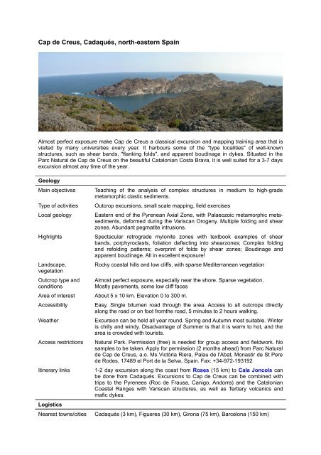
Almost perfect exposure make <strong>Cap</strong> <strong>de</strong> <strong>Creus</strong> a classical excursion and mapping training area that is<br />
visited by many universities every year. It harbours some of the "type localities" of well-known<br />
structures, such as shear bands, "flanking folds", and apparent boudinage in dykes. Situated in the<br />
Parc Natural <strong>de</strong> <strong>Cap</strong> <strong>de</strong> <strong>Creus</strong> on the beautiful Catalonian Costa Brava, it is well suited for a 3-7 days<br />
excursion almost any time of the year.<br />
Geology<br />
Main objectives Teaching of the analysis of complex structures in medium to high-gra<strong>de</strong><br />
metamorphic clastic sediments.<br />
Type of activities Outcrop excursions, small scale mapping, field exercises<br />
Local geology Eastern end of the Pyrenean Axial Zone, with Palaeozoic metamorphic metasediments,<br />
<strong>de</strong>formed during the Variscan Orogeny. Multiple folding and shear<br />
zones. Abundant pegmatite intrusions.<br />
Highlights Spectacular retrogra<strong>de</strong> mylonite zones with textbook examples of shear<br />
bands, porphyroclasts, foliation <strong>de</strong>flecting into shearzones; Complex folding<br />
and refolding patterns; overprint of folds by shear zones; Boudinage and<br />
apparent boudinage. All in excellent exposure!<br />
Landscape,<br />
vegetation<br />
Outcrop type and<br />
conditions<br />
Rocky coastal hills and low cliffs, with sparse Mediterranean vegetation<br />
Almost perfect exposure, especially near the shore. Sparse vegetation.<br />
Mostly pavements, some low cliff faces<br />
Area of interest About 5 x 10 km. Elevation 0 to 300 m.<br />
Accessibility Easy. Single bitumen road through the area. Access to all outcrops directly<br />
along the road or on foot fromthe road, 5 minutes to 2 hours walking.<br />
Weather Excursion can be held all year round. Spring and Autumn most suitable. Winter<br />
is chilly and windy. Disadvantage of Summer is that it is warm to hot, and the<br />
area is crow<strong>de</strong>d with tourists.<br />
Access restrictions Natural Park. Permission (free) is nee<strong>de</strong>d for group access and fieldwork. No<br />
samples to be taken. Apply for permission (2 months ahead) from Parc Natural<br />
<strong>de</strong> <strong>Cap</strong> <strong>de</strong> <strong>Creus</strong>, a.o. Ms Victòria Riera, Palau <strong>de</strong> l'Abat, Monastir <strong>de</strong> St Pere<br />
<strong>de</strong> Ro<strong>de</strong>s, 17489 el Port <strong>de</strong> la Selva, <strong>Spain</strong>. Fax: +34-972-193192<br />
Itinerary links 1-2 day excursion along the coast from Roses (15 km) to Cala Joncols can<br />
be done from <strong>Cadaqués</strong>. Excursions to <strong>Cap</strong> <strong>de</strong> <strong>Creus</strong> can be combined with<br />
trips to the Pyrenees (Roc <strong>de</strong> Frausa, Canigo, Andorra) and the Catalonian<br />
Coastal Ranges with Variscan structures, as well as Tertiary volcanics and<br />
mafic dykes.<br />
Logistics<br />
Nearest towns/cities <strong>Cadaqués</strong> (3 km), Figueres (30 km), Girona (75 km), Barcelona (150 km)
Airports Girona (75 km), Barcelona (150 km), Perpignan (100 km)<br />
Hotels Many hotels in tourist resort <strong>Cadaqués</strong>: from about 30 €/night<br />
Bungalows & hostels Club Carpe Diem (<strong>Cadaqués</strong>): 70-110 €/night for 6-7 person bungalow,<br />
Lighthouse lodging (<strong>Cap</strong> <strong>de</strong> <strong>Creus</strong>): ....€/night groups of 6 (<strong>de</strong>pends on<br />
season)<br />
Camping Camping <strong>Cadaqués</strong> (<strong>Cadaqués</strong>): from 15 €/night (very basic)<br />
Car rental <strong>Cadaqués</strong>, Roses, Girona (airport), Barcelona, etc.<br />
Restaurants Lighthouse restaurant & bar (in the area- <strong>Cap</strong> <strong>de</strong> <strong>Creus</strong>) and many<br />
restaurants/bars in <strong>Cadaqués</strong>. Meals from about 12 €.<br />
Medic/hospital Medics & clinic in <strong>Cadaqués</strong>, main hospital in Girona (75 km)<br />
Other activities and<br />
attractions<br />
Information<br />
Bird watching and unique flora in the natural park. <strong>Cadaqués</strong> is a beach resort,<br />
offering beaches, swimming, diving, boat trips, etc. Salvador Dalí's house<br />
(<strong>Cadaqués</strong>) and museum (Figueres). Monastery of san Pere <strong>de</strong> Ro<strong>de</strong>s,<br />
Fortresses of Figueres (30 km) and Roses (15 km). Costa Brava.<br />
Contact persons Elena Druguet, Departament <strong>de</strong> Geologia, Universitat Autònoma <strong>de</strong><br />
Barcelona.<br />
elena.druguet@uab.es<br />
Paul Bons, Institut für Geowissenschaften, Universität Tübingen, Germany<br />
paul.bons@uni-tuebingen.<strong>de</strong><br />
Cees Passchier, Insitut für Geowissenschaften, Universität Mainz<br />
cpasschi@uni-mainz.<strong>de</strong><br />
Field gui<strong>de</strong>s Carreras, Druguet. Gui<strong>de</strong> to the <strong>Cap</strong> <strong>de</strong> <strong>Creus</strong> shear zones<br />
Topo-maps Hipermapa <strong>de</strong> Cataluna<br />
http://www10.gencat.<strong>net</strong>/ptop/AppJava/cat/actuacions/territori/hipermapa.jsp<br />
Geological maps 1:25:000 map of Catalunia,<br />
This map has insufficient <strong>de</strong>tail in the small area of interest. Maps in<br />
geological publications are more useful.<br />
References Bons, Druguet, Hamann, Carreras, Passchier (2004) Apparent boudinage in<br />
dykes. J. Struct. Geol. 26, 625-636.<br />
Carreras (2001) Zooming on Northern cap <strong>de</strong> <strong>Creus</strong> shear zones. J. Struct.<br />
Geol. 23, 1457-1486<br />
Druguet, Passchier, Carreras, Victor, <strong>de</strong>n Brok (1996) Analysis of a complex<br />
high-strain zone at <strong>Cap</strong> <strong>de</strong> <strong>Creus</strong>, <strong>Spain</strong>. Tectonophysics 280, 31-45<br />
Druguet (2001) Development of high thermal gradients by coeval<br />
transpression and magmatism during the Variscan orogeny: insights from<br />
the <strong>Cap</strong> <strong>de</strong> <strong>Creus</strong> (Eastern Pyrenees). Tectonophysics 332, 275-293.<br />
Carreras, J., Druguet, E., Griera, A., Sol<strong>de</strong>vila, J. 2004. Strain and <strong>de</strong>formation<br />
history in a syntectonic pluton. The case of the Roses granodiorite<br />
(<strong>Cap</strong> <strong>de</strong> <strong>Creus</strong>, Eastern Pyrenees). In: G I Alsop, R E Holdsworth, K J W<br />
McCaffrey, M Hand (eds.), Flow Processes in Faults and Shear Zones,<br />
307-319. Geological Society of London Special Publication.<br />
Carreras, J., Druguet, E., Griera, A. 2005. Shear zone-related folds. Journal<br />
of Structural Geology 27, 1229-1251<br />
Other remarks none<br />
Photos and maps:
Buckle fold in a sandstone layer<br />
folds in micaschist, being cut by a ductile shear zone<br />
D1 folds inbedding, overprinted by aS2 foliation (vertical)
Geological map from Bons et al, 2004.