Donald N. Miller - Volhynia
Donald N. Miller - Volhynia
Donald N. Miller - Volhynia

Create successful ePaper yourself
Turn your PDF publications into a flip-book with our unique Google optimized e-Paper software.
Name. Meaning unknown.<br />
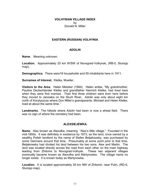
VOLHYNIAN VILLAGE INDEX<br />
by<br />
<strong>Donald</strong> N. <strong>Miller</strong><br />
EASTERN (RUSSIAN) VOLHYNIA<br />
ADOLIN<br />
Location. Approximately 20 km W/SW of Novograd-Volhynsk, (RB-5, Stumpp<br />
map).<br />
Demographics. There were18 households and 55 inhabitants here in 1911.<br />
Surnames of Interest. Kletke, Mueller.<br />
Visitors to the Area. Helen Metzker (1994). Helen writes, “My grandmother,<br />
Pauline Deutschlander Kletke and grandfather Heinrich Kletke, had lived here<br />
when they were first married. Their first three children were born here before<br />
they moved to Janowka on the Sluch River. Adolin was only about eight km<br />
north of Korytyszcze where Don <strong>Miller</strong>‟s grandparents, Michael and Helen Kletke,<br />
lived at about the same time.”<br />
Landmarks. The hillside where Adolin had been is now a wheat field. There<br />
was no sign of where the cemetery had been.<br />
ALEXSIEJEWKA<br />
Name. Also known as Alexufka, meaning “Alex‟s little village.” Founded in the<br />
mid-1850s. It was definitely in existence by 1873, as the land, once owned by a<br />
wealthy Polish landlord by the name of Stefen Beljakowsky, was purchased by<br />
some Germans around that time. Presumably at some point prior to that time,<br />
Beljakowsky had divided his land between his two sons. Alex and Martin. The<br />
land was located directly across the road from each other on the main highway<br />
leading from Zhitomir to Novograd-Volhysk. These two adjacent villages<br />
eventually became known as Alexufka and Martynowka. The village name no<br />
longer exists. It is known today as Martynowka.<br />
Location. It is located approximately 35 km NW of Zhitomir, near Pulin, (RD-5,<br />
Stumpp map).<br />
-1-
Demographics. In 1911.there were 23 houses and 193 inhabitants in the<br />
village. The regional post office was in Pulin and the railroad station in Zhitomir.<br />
The district post office, established around 1850, was located in Rudni (place of<br />
iron ore). There was also a flourmill established around the turn of the century<br />
and an open market. The land around there is flat and quite fertile. The railroad,<br />
which runs through Alexufka, was build around 1935.<br />
Surnames of Interest. Baier, Gaer, Domke, Druse, Ei, Eschner, Hauch, Henke,<br />
Jabs, Krieger, Krause, Lange, Lucius, Mueller, Neiman, Ostreich, Ortlieb,<br />
Radatz, Riske, Schiewe, Schramm, Schultz, Tomke, Qwiram, Weiss, Witzke,<br />
Woutske, and Ziebert<br />
.<br />
Visitors to the Area. Don and Harvey <strong>Miller</strong> and Audrey Hastings (1980).<br />
According to Don, “An old lady pointed to where the Mueller farm was located<br />
and a clump of willow bushes which she said that was one of the places where<br />
the German Baptists baptized their converts.” Don <strong>Miller</strong> and George Maser<br />
(1993, 1994). Darryl Schultz (2002), rode throughout the village on an old farm<br />
wagon pulled by two white stallions.<br />
Landmarks. The Baptist church, a station of Pulin, gathered in the home of<br />
Michael Mueller. The congregation consisted of about 70 persons. The children<br />
from Alexufka attended school in Martynowka, just across the highway from the<br />
Mueller place. In 1994 an old woman, Leskadia Palazhkvich, who lived next to<br />
the cemetery, now an overgrown grove of trees and goat field, said that during<br />
WW II, there was a fierce battle there. There are four or five raised mounds<br />
(graves), but no markers. Martha (Sagert) Schultz, Don <strong>Miller</strong>‟s grandmother,<br />
who died in 1922, is buried there, as well as a number of her children who died in<br />
infancy. The post office in Rudni was vacated around 2000. The post office and<br />
flourmill, today a milk and cheese factory respectively, are the only two remaining<br />
landmarks<br />
ALT-ALEXANDROWKA<br />
Name. Meaning “Alexander‟s little old village.”<br />
Location. Approximately 30 km NW of Zhitomir, near Vigoda, (RD-5, Stumpp<br />
map).<br />
Demographics. In 1911 there were 40 households and 318 inhabitants. There<br />
are many Ukrainian homes in the area today, including a large community<br />
warehouse on the south end of the village.<br />
Surnames of Interest. Kwast.<br />
-2-
Visitors to the Area. Don <strong>Miller</strong> (1995, 2004, 2007) and Dave Obee (1995),<br />
Harold Kwast (2004).<br />
Landmarks. The old Lutheran church, turned into a school, is now abandoned.<br />
It is located at the northeast end of town (south side) of the road to Pulin. Next to<br />
it is an old abandoned German house. The church is gone. There is a German<br />
cemetery there with a few remaining stones. One reads: Herman Lau and son<br />
Adolf Lau. The cemetery is located a short distance from the church-school in a<br />
woods on the south side of the road leading to Pulin. It now serves as the local<br />
garbage dump. East of the cemetery is a large open field that had been the<br />
location of most of the German houses prior to WW II. The lady who guided us<br />
to the spot stated that the grass in the field was very different from the “local<br />
grass” and had been imported by the German colonists. There is a very nice<br />
school there today. In 2007 the Headmaster said that in a couple of years the<br />
school will be closed due to declining population. Germans remembered: Heise,<br />
Holtz, Bloch, Schott, Brendal, Finke, Freeland. There were three collective farms<br />
there. Paul Baladuga, an old Ukrainian, is quite knowledgeable.<br />
Name. Also Andrejev.<br />
ANDREJEW<br />
Location. Approximately 20 kms straight north of Zhitomir on the road to<br />
Korosten (RE-5, Stumpp map).<br />
Demographics. In 1911 there were72 houses and 664 inhabitants.<br />
Surnames of Interest. Roleder, Boedner.<br />
Visitors to the Area. Ella Ritz (1994). George Roleder (2003).<br />
Landmarks. Found the large German cemetery, but no stones.<br />
Name. Meaning unknown.<br />
BABYTSCHIEWKA<br />
Location. Approximately 30 km west of Zhitomir, (RD-5, Stumpp map).<br />
Demographics. In 1911 there were 20 households and 137 inhabitants in the<br />
village.<br />
Surnames of Interest. Kwast, Lange, Merk.<br />
-3-
Visitors to the Area. Don <strong>Miller</strong> (1998). Found a second cousin there Lillie<br />
Sanyon, Lillie is a daughter of Emil Lange, brother to Edmund Lange, my uncle.<br />
Lillie has two sisters in Germany, Erna Buchmann (Gifhorn) and Adina Dold<br />
(Minden).<br />
Landmarks. There is an old windmill almost directly across from Lillie‟s house.<br />
Since the windmill is only a couple of km from Alexufka, it is quite likely that my<br />
grandfather, Michael Mueller, ground his grain there.<br />
Name. Meaning unknown.<br />
BEROSOWKA<br />
Location. There are three Berosowkos in <strong>Volhynia</strong>. This one is located about<br />
10 km west of Zhitomir (RD-5, Stumpp map).<br />
Demographics. In 1911 there were 30 houses and 212 inhabitants.<br />
Surnames of Interest. Emmer(t), Gottschalk, Kwast, Tasch.<br />
Visitors to the Area. Harold Kwast (2003).<br />
Landmarks. The family of Nikolas Arndt built a well-known school here. The<br />
school still stands as a landmark today.<br />
Name. Meaning: “Valley of flowers.”<br />
BLUMENTAL<br />
Location. Approximately 30 km NW of Zhitomir, near Pulin, (RD-5, Stumpp<br />
map).<br />
Demographics. No record available. Today only a few houses remain. It is<br />
quite flat and spread out in the village.<br />
Surnames of Interest. Bohn, Emmer(t), Deger, Gottschalk, Tasch.<br />
Visitors to the Area. Waldemar Bohn (1993), Dave Obee (2002), Albert<br />
Schmidt and Rita Reddon (2007). An old man by the name of Sergei reported<br />
that he went to school with Tasch‟s daughters. Found the general area where<br />
Andreas Tasch lived and had his house church.<br />
Landmarks. None.<br />
-4-
Name. Also Kholosno.<br />
CHOLOSNO<br />
Location: Approximately 60 km north of Zhitomir near Korosten, or 10 km south<br />
and slightly east of Korosten, (RE-3, Stumpp map).<br />
Demographics. In 1911 there were 226 households and 377 inhabitants. There<br />
are about 700-800 Ukrainians in the village today.<br />
Surnames of Interest. Braun, Bredin, Edel, Langer, Stober, Bush.<br />
Visitors to the Area. Don <strong>Miller</strong> (1995, 2000, 2004) and Frida Semrau (2002)<br />
Landmarks. Met a family by the name of Langer, a German married to a<br />
Ukrainian, whose son took us in his BMW to an area near the RR tracks, pointed<br />
to a knoll covered with bush and said, “That‟s where the old German Baptist<br />
cemetery was. A wooden church building once stood nearby.” The Baptist<br />
Church building is gone, but Maria Stepanovna, an elderly Ukrainian<br />
schoolteacher who lives in the area remembers it clearly. She showed us the<br />
place where the building used to be. “I remember the people had a spirit of<br />
gladness,” she said. “I loved to hear them sing.” There was also a barn for the<br />
horses. It appears that the Baptist church was technically in Vesyelowka or there<br />
may have been a Baptist church in both Cholosno and Vesyelowka. She spoke<br />
of the school and Neuman, the teacher. She also pointed us to the German<br />
section of the Ukrainian cemetery. One stone was found: Waldemar Wedel, born<br />
1917. Died 1942.<br />
DIMITROWKA<br />
Name. This village was better known as Schmallmittag, “Skimpy meal,” likely<br />
derived from some unknown Slavic dialect (Dimi, small; trowka, meal). Or it may<br />
have been Dimitry‟s little village.<br />
Location. Approximately 20 km NNE of Novograd-Volhynsk, (RC-4, Stumpp<br />
map). It is quite difficult to find. To get to it, go about two km west of the<br />
Witterman farm in Moisejewka, turn left at the main road and go down about<br />
another two km. As best as we can tell, it is on the left side of the road. The trail<br />
through the woods leading to the settlement is very low.<br />
Demographics. There were 19 households and 76 inhabitants here in 1911.<br />
The soil, rather improverished and sandy, struggled to produce much. Land is<br />
very low. The settlers must have had a major job draining the swamp.<br />
-5-
Surnames of Interest. Bach.<br />
Visitors to the Area. Don <strong>Miller</strong> (1994), Eileen Beck (2004). One house,<br />
approximately two km back from the road, remains. It was boarded up with<br />
furniture still inside.<br />
Landmarks. Eileen Bech writes, “Dimitrowka remains only as a memory.<br />
According to an elderly couple living in Katerynowka, there is one house left.<br />
And we found it! It was abandoned as if someone had walked away, leaving an<br />
old newspaper from 1998.” A 1916 map indicated a small cemetery on the east<br />
side of the main road running north and south, not more than several hundred<br />
meters from the road. The cemetery was found by the tour group in 2004. Also<br />
found were a number of large rocks and fruit trees further in.<br />
Name. Meaning: “Elizabeth‟s field.”<br />
EISAWETPOL<br />
Location. Approximately 60 km NW of Zhitomir, (RD-4, Stumpp map). The<br />
village is off the main road and difficult to get to.<br />
Demographics. In 1911 there were 37 households and 261 inhabitants.<br />
Surnames of Interest. Giesbrecht.<br />
Visitors to the Area. Bernard Giesbrecht (1994).<br />
Landmarks. There is nothing left except one house in the distance.<br />
Name. Meaning: Belonging to Emil.<br />
EMILTCHIN<br />
Location. Approximately 50 km north of Novograd-Volhynsk.<br />
Demographics: In 1911 there were 423 households and 2,840 inhabitants. In<br />
1926 there were 3,609 inhabitants.<br />
Surnames of Interest.<br />
Visitors to the Area. Don <strong>Miller</strong> and George Maser (1993).<br />
Landmarks. There is a huge lake in the village.<br />
-6-
Name. Meaning: some kind of valley.<br />
EVENTAL<br />
Location. Approximately 15 km NW of Sorotschin, (RD-4, Stumpp map). The<br />
village is hard to find on rough cobblestone and dirt roads.<br />
Demographics. No record available. After WW II, there were 47 houses. Now<br />
only one left on the edge of the forest.<br />
Surnames of Interest. Domries, Henschel.<br />
Visitors to the Area. Oliver Domries (1993), Don <strong>Miller</strong> (1998).<br />
Landmarks. Waldemar Podolynchuk, the only resident in the village, took us by<br />
horse and wagon to the Lutheran cemetery. Found two stones, flowers and<br />
wooden markers. The Lutheran church was at the entrance of the cemetery and<br />
the school at the end. Nothing remains. There once was also a small Baptist<br />
house church. In the early 90s some people came from Germany and dug up<br />
the remains of several people and took them back to Germany for reburial.<br />
Podolynchuk said there are still wolves in the area. He often hears them howl.<br />
FASSOWAJA-RUDNIA<br />
Name. Also Rudnia-Fasoviia, having to do with iron ore.<br />
Location. Approximately 40 km north of Zhitomir, (RE-4, Stumpp map).<br />
Demographics. There were 106 households here in 1911 and 680 inhabitants.<br />
Surnames of Interest. Bodener, Kremring, Schultz, Roleder.<br />
Visitors to the Area. Ella Ritz (1994) and George Roleder (2002). The German<br />
settlement was originally located to the south of the RR tracks, but nothing<br />
remains, except a few Ukrainian houses on the west side of the main road<br />
leading into the village.<br />
Landmarks. There is a little mound in an open field near a lilac bush. A local<br />
villager working nearby told us there once were two mills on this spot. One was<br />
an indoor mill, pulled by horses, and the other was a windmill. The Bodener<br />
family, parents of Ell Ritz, operated an oil “muhl” here and farmed in the area.<br />
-7-
FEDEROWKA<br />
Name. Meaning: “Feder‟s little village.” There are a number of Federowkas in<br />
the area. This one goes by the name of Kaliniwka today.<br />
Location. It is located about 25 km north of Zhitomir (Stumpp map, RE-4) just<br />
west of Toporischtsh on the main highway to Korosten.<br />
Demographics. In 1911 it had a population of 65 houses and 615 inhabitants.<br />
Today there are about 25 houses stretching over a couple of km.<br />
Surnames of Interest Kuehn, Ristau, Tomtschik (shot in Tschernjachow),<br />
Schmidt.<br />
Visitors to the Area. John Tomtschik and his mother, Waltraud (2002 and<br />
Albert Schmidt and Rita Reddon (2007). Eighty-year old Melanya Somolyenko<br />
remembered the Tomtschik family and gave directions to the family farm. The<br />
Tomtschiks also found the stream, which ran through the farm where John‟s<br />
father went fishing. Gabriele Goldstone (2004). Old lady remembered the<br />
names, Semrau, Kuehn, Ristau, Kopanski, Nickle<br />
Landmarks. There is a large German cemetery, now completely overgrown,<br />
with one marker, an iron cross, remaining. There was a windmill here, owned by<br />
Ristau. It was dismantled and the wood used to construct the home of the<br />
manager of the collective farm. Found the hill, mound and foundation stones<br />
where it once stood. There is a stream across the road. There is a war<br />
memorial in the center of the village. The Lutheran church and school stood near<br />
it.<br />
Name. Meaning: “Peaceful village”.<br />
FRIEDENSDORF<br />
Location. There are three villages by this name. One, according to the Stumpp<br />
map, is located at RC-4, about 22 km ESE of Novograd-Volhynsk and the other<br />
is located on the same map at RC-6, approximately 45 km south of Novograd-<br />
Volhynsk. According to the Wojskowy Institute Geography, Warsaw, 1931, map,<br />
there is a third village by this name. It is NW of Novograd-Volhynsk. This report<br />
deals with the first location. The Stumpp map shows the village to be between<br />
Nikolajewka and Ulaschanowka. The village does not exist today. It is simply an<br />
open field of grass and grain.<br />
Demographics. No record available. The soil appears to be mostly sandy.<br />
Surname of Interest. Lange, Arndt.<br />
-8-
Visitors to the Area. Ken Krell (2002, 2004), David Lange (2004). Ken states,<br />
“We drove about 10 km west of Rudokop, and found a young man on a bike who<br />
was willing to show us the place where his father said the village once existed.<br />
There was nothing there, except an old abandoned concrete bridge built in the<br />
1930s. After I returned home, I checked Jerry Frank‟s map and concluded that<br />
Friedensdorf may actually be a bit to the east of Nikolajewka. I want to re-visit<br />
the area someday.”<br />
Landmarks. The young man showing us around said that his father recalled that<br />
there was a German cemetery to the north of where the concrete bridge is<br />
located.<br />
FRIEDENSTAL<br />
Name. Meaning: “Joyful place”. The village is now called Mirnoe.<br />
Location. Approximately 50 km NW of Zhitomir, (RD-4, Stumpp map)<br />
Demographics. No record available.<br />
Surnames of Interest. Family of Edith Greene.<br />
Visitors to the Area. Edith Greene (1994). Met an old villager on a bicycle by<br />
the name of Ewald Neumann. He was 70 years old and quite knowledgeable.<br />
He showed us where the parental home of Edith Greene stood. There was<br />
nothing left but a little indentation in the ground and a small hole where the well<br />
was. Ewald remembered the family names of Krule, Schultz, Kashinski (?) and<br />
Kalbert. George Maser and his tour group re-visited the village in June 1998.<br />
Landmarks. Neumann also knew the location of the old Germany cemetery. He<br />
said the Lutheran church stood nearby. He reported that the church was<br />
pastored by a Gottlieb Polinski, a Breitkreuz and a Herter. In the cemetery we<br />
found gravestones bearing the names of Gottlieb Polinski (1831-1908) and<br />
Louise Polinski nee Gebauer (1837-1909). The discovery of the Polinski name<br />
was of special significance to Bernard Giesbrecht, tour member, who knows<br />
Erwin Polinski, a great grandnephew of Gottlieb, living in Vancouver, BC. There<br />
is a little country store there now<br />
FRIEDRICHSDORF<br />
Name. Meaning: “Friedrich‟s village.” This was the Germanic name. Solomka is<br />
the original as well as the modern name for the village.<br />
Location. Friedrichsdorf is located in Polish <strong>Volhynia</strong> (PE-3, Stumpp map)<br />
almost straight north of Rowno.<br />
-9-
Demographics. No record available.<br />
Surnames of Interest. Frederking.<br />
Visitors to the Area. Bob Frederking (2004). None of the villagers recalled any<br />
German names.<br />
Landmarks. None.<br />
GNADENTHAL<br />
Name. Meaning: “Valley of grace or blessing.”<br />
Location. Approximately 20 km north of Pulin (RD-4, Stumpp map).<br />
Demographics. No record available.<br />
Surnames of Interest. Wuerch.<br />
Visitors to the area. Carol Jones (2002). German families remembered: File,<br />
Radke, Schilke, Sonnenberg, Stelter, Kreiger and Wuerch. Wuerch, first name<br />
unknown, had mill driven by a diesel engine, which he brought in from Germany<br />
around 1926/1927. It was reported that the farmers had to take their grain to the<br />
big (Bergstresser ?) mill in Sorotschin to be ground. Often there were long lines.<br />
Wuerch became angry that he had to wait so long all the time and so he decided<br />
to get his own mill. The mound where the mill was located remains, but the<br />
engine was sold for scrap metal after the war.<br />
Landmarks. The old Lutheran school was used until about 10 years ago. It<br />
was very large with many rooms. A few stones remain in the unattended<br />
German cemetery. A house church, similar in design to the Baptist Church in<br />
Sorotschin, burned to the ground in 1944.<br />
GRUENTAL<br />
Name. Meaning: “Green valley.” Current name: Zelenaja Poljana.<br />
Location. Approximately two km NW of Heimtal. Kutozowka is just to the north<br />
of here.<br />
Demographics. No record available.<br />
Surnames of Interest. Kwast<br />
-10-
Visitors to the Area. George Maser and his tour group (1998), Harold Kwast<br />
(2003). The road to the village was terrible, merely trails across rough fields with<br />
many potholes.<br />
Landmarks. There is a post office at the four corners of the present village.<br />
(Nothing remains of Kutozowka). The cemetery that served the two villages is<br />
located a short distance to the east of the Four Corners on the north side of the<br />
road. There was a German section, totally unkempt, with one stone remaining.<br />
HEIMTAL<br />
Name. Meaning: “Home in the valley.” It is currently named Yasinuvka. It was<br />
once also known as Starja Buda.<br />
Location. Heimtal is located approximately 50 km NW of Zhitomir, (RD-4,<br />
Stumpp map). Heimtal was the home of the German training seminary and<br />
teacher‟s college, founded in 1904 or so.<br />
Demographics. In 1911 there were 64 houses and 593 inhabitants. It was solid<br />
German. Heimtal was once a notable agricultural, educational, cultural and<br />
religious center. By 1923 it had a credit union, a large milk processing factory,<br />
three libraries, a number of mills, a children‟s hospital, a newspaper publishing<br />
company, a local theatre, a large Lutheran church and a teacher‟s training school<br />
and seminary, originally established in 1905. The 40-room seminary building<br />
was virtually destroyed during the Second World War. The soil is quite sandy.<br />
Surnames of Interest. Bergstresser, Less, Rohleder.<br />
Visitors to the Area. Don <strong>Miller</strong> (1993, 1994), George Maser and his tour<br />
group (1998), Harold Kwast and George Roleder (2003), and Eileen Bech<br />
(2004). We were told Irwin Stobb from Edmonton, AB visits the village every<br />
year.<br />
Landmarks. The wooden building of the Lutheran Church and manse has been<br />
destroyed, however the large school building still stands, though in ruins. Also<br />
the 40-room teacher‟s college and seminary building, which was virtually<br />
destroyed during WW II, is still standing. The cemetery is still in use. The<br />
German section has been largely neglected and desecrated. A number of<br />
tombstones remain: Friedrich Kern (1891-1920), Ludwig Kern (1854-?), Louise<br />
Kern (1856-1929), Friedrich Bergszten, possibly Bergstresser (1879-1884),<br />
Friedrich Diewert (1842-1894), Christian Drews (1841-1923), Wilhemine Drews<br />
(1849-1927), Johann Friedrich Krenz (1829-1900), Cecilia Berta Schulz (1904-<br />
1907), Ferdinand Steinke (1880-1905), Friedrich Steinke (1873-1916). There<br />
was also a Wasem, Christina Schmidt and Fuchs.<br />
-11-
Name. Meaning unknown:<br />
KISHELOWKA<br />
Location. Kishelowka is located about three km northeast of Pulin (RD-4,<br />
Stumpp map).<br />
Demographics. No record available.<br />
Surnames of Interest. Lange<br />
Visitors to the Area. Don Richter, Alice Eckhart (2002).<br />
Landmarks. Big hops field.<br />
Name. Meaning: “Helen‟s little village.”<br />
HELENOWKA<br />
Location. Located approximately 35 km north of Zhitomir (RE-4, Stumpp map).<br />
Demographics. In 1911 there were 32 houses and 286 inhabitants in the<br />
village. Today the village has perhaps about 20 houses.<br />
Surnames of Interest. Stolz.<br />
Visitors to the Area. Ella Ritz (1994 and George Roleder (2003).<br />
Landmarks. There is a rather large German cemetery in Helenowka on the east<br />
side of the road near the railroad tracks. It is now used by the Ukrainians.<br />
Name. Also Gorschchik.<br />
HORSTSCHICK<br />
Location. Approximately 25 km SW of Korosten (RD-3, Stumpp map).<br />
Demographics. There were 116 families and 600 inhabitants in the village in<br />
1911.<br />
Surnames of Interest. Bonikowski, Mantler, Richter, Steinke, Wigowski, Renz.<br />
Visitors to the Area. Don <strong>Miller</strong> and George Maser visited the village in 1993.<br />
We were told that there used to be a lot of Steinkes in the area. Germans<br />
remembered were Schuster and “Brother Steinke,” an elder in the Baptist church.<br />
-12-
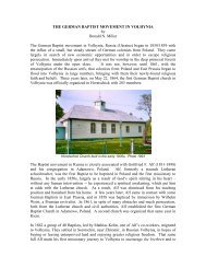
Landmarks. Horstschick was the location of the first German Baptist Church<br />
established in <strong>Volhynia</strong> on May 19, 1864. The original building, though<br />
remodeled a number of times, is still standing today. The Russian Orthodox<br />
Church now owns it. A large cemetery with an overgrown German section is<br />
located nearby. Several German tombstones remain: Auguste Pampuch (1876-<br />
1909) and her daughter Emile Retchka (19__-1931), buried side by side. Two of<br />
Emil Bonikowski‟s daughters are buried there. Bonikowski, a pastor, served the<br />
church from 1920-1923. The cemetery is still in use today.<br />
Name. Ivan‟s place.<br />
IVANOWITSCH<br />
Location. The village is located approximately 30 km W/NW of Zhitomir, near<br />
Pulin (RD-5, Stumpp map). Entrance to the village is on a long dirt road, very<br />
rough.<br />
Demographics. In 1911 there were 63 families and 603 inhabitants in the<br />
village, most of them German. The river Irscha runs through it. There was also a<br />
large Czech community south of the German colony.<br />
Surnames of Interest. Hornbacher, Lebuski, Martin, Nickle, Obee, Tiedtke,<br />
Reschke,<br />
Visitors to the Area. Don <strong>Miller</strong> and George Maser (1993), and Dave Obee and<br />
Don <strong>Miller</strong> (1995).<br />
Landmarks. The church was destroyed in the 1930s and the nearby cemetery is<br />
overgrown with weeds and shrubs. In 1995, we found one gravestone with the<br />
following inscription: Wohl dem seine Hoffnung setzt; auf den Herrn; heir ruht im<br />
Herrn Olga Bankowski geborene Reschke, geb. Den 6. Marz 1913, gest. Den 26<br />
September 1942.<br />
Name. Meaning: “Ivan‟s little village.”<br />
IVANOWKA<br />
Location. Located approximately 50 km north of Zhitomir on the east side of the<br />
main highway (RE-3, Stumpp map).<br />
Demographics. No information available.<br />
Surnames of Interest.<br />
Visitors to the Area. Don <strong>Miller</strong> (2003, 2004).<br />
-13-
Landmarks. The most significant landmark is the old German windmill outside<br />
the present village.<br />
Name. Meaning: “Julian‟s little village.”<br />
JULIANOWKA<br />
Location. Located approximately15 km west of Zhitomir (RE-5, Stumpp map).<br />
The road leading out of Julianowka is cobblestone. Terribly rough.<br />
Demographics. In 1911 there were 59 houses and 533 inhabitants. In the<br />
1940s there were about 20 families in the village.<br />
Surnames of Interest. Bohn, Kwast.<br />
Visitors to the Area. Waldemar Bohn (1994) met his boyhood school friend.<br />
Harold Kwast (2003).<br />
Landmarks. Vladimir Kowalchuk, a 78-year old gentleman and former<br />
schoolmate of Waldemar Bohn, recalled the names of many German colonists,<br />
but little remains. There is one broken stone in the cemetery. The road leading<br />
out of Julianowka is cobblestone. Terribly rough.<br />
Name. Meaning John‟s little village.<br />
JANOWKA<br />
Location. There are eight Janowkas in <strong>Volhynia</strong>. This one is located<br />
pproximately 60 km W/NW of Zhitomir and five or six km north of Skolow, (RD-4<br />
on the Stumpp map).<br />
Demographics. In 1911 there were12 households and 75 inhabitants.<br />
Surnames of Interest.<br />
Visitors to the Area. Don <strong>Miller</strong> (1999).<br />
Landmarks.<br />
Name. Meaning: “Justin‟s little village.”<br />
JUSTINOWKA<br />
Location. Approximately 25 km W/NW of Zhitomir, (RD-5, Stumpp map).<br />
Demographics. In 1911 there were 37 household and 342 inhabitants.<br />
-14-
Surnames of Interest. Gutowski, Lange, Merk.<br />
Visitors to the Area. Don <strong>Miller</strong> and Dave Obee (1995).<br />
Landmarks. A local resident showed <strong>Miller</strong> and Obee the location of the Baptist<br />
and Lutheran churches, and the Germany cemetery. One stone remains:<br />
Name. Meaning unknown.<br />
KAROLIN DERMAN<br />
Location. Approximately 50 km west of Zhitomir, (RC-5, Stumpp).<br />
Demographics. In 1911 there were36 households and 204 inhabitants. At<br />
present there are only two streets with about a half a dozen homes on each<br />
street.<br />
Surnames of Interest. Tiede.<br />
Visitors to the Area. Dwayne and Leon Tiede (2002). No one remembered<br />
any names.<br />
Landmarks. According to Tiede family members there was a Baptist church in<br />
Karolina Derman, possibly also a Lutheran church.<br />
Name. Meaning: “Katrya‟s little village.”<br />
KATRYNOWKA<br />
Location. Approximately 15 km north of Novograd-Volhynsk, (RC-4 on the<br />
Stumpp map).<br />
Demographics. In 1911 there were 30 households and 500 inhabitants.<br />
Surnames of Interest. Bach.<br />
Visitors to the Area. Don <strong>Miller</strong> and George Maser (1994), Eileen Beck (2004).<br />
Paul and Alma Valenkevitch, an elderly couple, remembered the following<br />
Germans in the area, mostly Moisejewka: Radke, Rinas, Schultz, Becker,<br />
Witterman (had three sons, one deaf and dumb and a team of stallions; also<br />
ponies), Kelm, Ruks, Marquart, Schmidtke, Nikolai. Served us vodka from his<br />
their own still.<br />
-15-
Name. Meaning unknown.<br />
KRASSNAJA-RETACHKA<br />
Location. Approximately 40 km south of Korosten, (RE-4, Stumpp map).<br />
Demographics. In 1911 there were 74 households and 507 inhabitants. Today<br />
the village is pretty much depleted.<br />
Surnames of Interest. Bodener, Stolz..<br />
Visitors to the Area. Ella Ritz (1994). Found an old Ukrainian woman (87),<br />
Maria Sigert Mianowski, who spoke German fluently. She was born in Torchin<br />
and knew the Kuehn families. “There were three of them,” she said, “Gottlieb,<br />
August and Gustav. They called them the „rich Kuehns.‟” Names remembered<br />
were Schuh and Bodener. Gabrield Goldstone (2004).<br />
Landmarks. There was a Lutheran church here and a cemetery. A windmill is<br />
still standing today near the collective farm. A large battle ensued here during<br />
WW II and the village was burned to the ground.<br />
KROSCHNA<br />
Name. Meaning: Something having to do with pebbles.<br />
Location. Approximately10 km west of Zhitomir.<br />
Demographics. There were 96 households and 435 inhabitans in 1911.<br />
Surnames of Interest. Friend of Robert Handel.<br />
Visitors to the Area. Robert Handel (1994).<br />
Landmarks. None.<br />
LESO BUDA<br />
Name. Meaning: A small place. See Lesowschtschina for additional<br />
information.<br />
Location. Approximately 20 km south of Koreston and three km south of<br />
Lesowschtschina.<br />
-16-
Demographics. Mining in the area. Everything is uprooted.<br />
Surnames of Interest. Lange, Krell.<br />
Visitors to the Area. David Lange and Ken Krell (2007). An elderly woman,<br />
Antona Ochman (83), whose father was German remember a Lange or perhaps<br />
a Langer, who was a school teacher in the 1920s. She also remembered a<br />
heidel.<br />
Landmarks. There are now about a dozen homes in the area. There is a<br />
titanium plant in the area.<br />
Name. Meaning: “Forest land.”<br />
LESOWSCHTSCHINA<br />
Location. Located near Korosten 56 km north of Zhitomir (Stumpp‟s map: RE-<br />
3). Two places appear on current maps, Lesowschtschina and Leso Buda.<br />
Lesowschtschina is 56 km north of Zhitomir and 17 kilometers south of Korosten<br />
on the main highway linking the two towns. Leso Budo is three km south of<br />
Lesowschtschina and 21 kilometers south of Korosten. There is a large titanium<br />
mine south of Lesowschtschina with the processing plant to the southwest.<br />
Apparently an older Lesowschtschina was displaced by part of the mine.<br />
Demographics. In 1911 there were 36 houses with 310 inhabitants. The<br />
railroad station and the regional post office were in Korosten. The village no<br />
longer exists today. Apparently all the inhabitants were relocated to Rosovka in<br />
1930. The soil in the area is very sandy and rich with minerals.<br />
Surnames of Interest. Reschke, Lange, Braun, (had a son, Daniel, who<br />
become president of the German Baptist Seminary in Odessa.) Poppke.<br />
Visitors to the Area. Herb Poppke (1993), Ken Krell (2002). At the time there<br />
were two remaining houses. David Lange and Ken Krell (2004), Ken Krell<br />
(2007).<br />
David Lange reports, “After we visited the market in Tschernjachow, Neudorf<br />
Baptist Church and Ostrowka we headed north to Leso Buda. After stopping to<br />
photograph the titanium mine from the highway we turned left driving past the<br />
mine mills, past more mine (tailings pond?) and then over a bridge over a long<br />
conveyor belt carrying ore to the processing plant. A little further on we turned<br />
left going through a small section of woods to the small village of Leso Buda. In<br />
Leso Buda we talked with an elderly lady named Antona Ochman who is 83<br />
years old. Her father is German and was born in 1885 and her mother is Polish<br />
(maiden name Schadika). They were there during the war. She remembered a<br />
-17-
Lange or Langer, who was a schoolteacher in the 1920s. Also remembered the<br />
German name Heidel. She said there was once a German Catholic Church<br />
across the street from her house. Leso Buda was not a very big village, 10-15<br />
homes, but we did not stay in the area very long and I did not see very much<br />
beyond the Ochman‟s. Several of us from the tour group walked around the<br />
corner of the road and saw a school.<br />
“Driving out we stopped near the bridge so we could take some pictures of the<br />
long conveyor belt for which we could not see either end. We pulled off in a<br />
small wooded area for lunch. After lunch we took a farm road going northwest of<br />
Lesowschtschina heading to the site of the old village, Colony Lesowschtschina.<br />
After a couple of kilometers we came to a good-sized woods and the road<br />
became very muddy so we turned around. From Lesowschtschina we continued<br />
north on the main highway for about 10 kilometers and at a large rotary turned<br />
SW leading to Uschomir. Passing through Uschomir, we went as far as we could<br />
and were told that the road from the north was impassable as well. Uschomir<br />
was a very beautiful village with designs painted on many of the homes and we<br />
all took pictures.”<br />
Landmarks. There was once a German Lutheran church, Baptist station and<br />
school there. Nothing remains. There was once also a German cemetery. When<br />
Herb Poppke was there in 1993, Evdokiya, an old woman in Leso Buda told him<br />
“the old cemetery is buried under the titanium plant located north of the village.”<br />
The exact location is unknown. There is a titanium mine there. In 2007 we<br />
toured it.<br />
LUDWIKOWKA<br />
Name. Meaning: “Ludwig‟s little village.”<br />
Location. Approximately 25 km west of Zhitomir (RE-5, Stumpp map). It is<br />
located across the road from Alt-Alexandrowka on the main highway from<br />
Zhitomir to Pulin.<br />
Demographics. There were 29 households and 242 inhabitants in 1911.<br />
Surnames of Interest. Gerlitz.<br />
Visitors to the Area. Don <strong>Miller</strong> (1994).<br />
Landmarks.<br />
-18-
MARIANKA<br />
Name. Meaning unknown. The current name is Buriakovka. Local residents<br />
claim that the village of Jerusalemka has been incorporated with Marianka.<br />
Location. Located about 30 km NW of Zhitomir and four km SE of Pulin (RD-5,<br />
Stumpp map).<br />
Demographics. In 1911 there were 42 houses and 333 inhabitants in the<br />
village. There was no post office or railway station. The current population is<br />
estimated to be about 150-200.<br />
Surnames of Interest. Family of Edith Greene, and Frederking.<br />
Visitors to the Area. Edith Green (1994). Bob Frederking (2004). Bob<br />
Frederking talked to Lily Grams, about 80, a German whose maiden name was<br />
Eisner. She told that her parents were exiled in 1932 when she was 12. She<br />
and her brother remained behind with family and friends.<br />
Landmarks. In 1994 the wooden building of the Lutheran Church was still<br />
standing, but it was in poor condition. It was used as a clubhouse. Residents at<br />
that time spoke of repairing it, but it never materialized. It was torn down around<br />
2002 and the lumber used to build a house. A stone slab, which once served as<br />
an entrance step, is still there. The huge trees surrounding the tress have been<br />
cut down. The German cemetery, which was close to the church, is no longer<br />
there. A Ukrainian cemetery is located about a block from where the church<br />
once stood. Lily Grams said that there was still one German house remaining in<br />
the village, formerly owned by a Drachenberg. The Lutheran school is still<br />
standing, but has been removed to serve as a house. Nadia Veselovska, still<br />
living, taught there for 30 years.<br />
German names remembered: Stockman, Pfeiffler, Shute, Lange, Witzke, Renz,<br />
Renus, Krostroki, Falski, Drieman, Drachenberg.<br />
Name. Meaning unknown.<br />
MARISCHOWKA<br />
Location. Approximately 12 km S/SE of Novograd-Volhynski.<br />
Demographics. No information available.<br />
Surnames of Interest. Family of Edith Green.<br />
-19-
Visitors to the Area. Edith Green, together with Don <strong>Miller</strong> and George Maser,<br />
tour guides, visited the village in 1994. Met a German woman by the name of<br />
Elsa Stolze who lived there with her son. She said that her husband was so<br />
loved and respected in the community in the 1930s that they let them stay while<br />
the rest of the family was shipped to Siberia.<br />
Landmarks.<br />
Name. Meaning: “Martin‟s little village.”<br />
MARTYNOWKA<br />
Location. Approximately 35 km west of Zhitomir (RD-5, Stumpp map).<br />
Demographics. In 1911 there were 48 households and 453 inhabitants. In<br />
1926 a village council was formed comprising four villages: Martynowka,<br />
Alexufka, Rudni and Lodzjanowka. These four villages had a combined<br />
population of 1,421, of which 1,201 were Germans. Sometime between 1926-<br />
1941, the four villages were united into one called Martynowka.<br />
Surnames of Interest. Kwast.<br />
Visitors to the Area. Don <strong>Miller</strong> and George Maser (1993, 1994).<br />
Landmarks. The Lutheran school was officially opened in 1887. The first<br />
teacher was Friedrich Wollenberg. The school continued to be used for over 100<br />
years when a new school was built on the other side of the road in the late 1990s<br />
near of on the property originally owned by Schultz. The cemetery is located<br />
approximately two km north of the school. It is used today by the Ukrainians.<br />
Place. Meaning unknown<br />
MITROWKA<br />
Location. Approximately 20 km N/NE of Novograd-Volhynski, (RC-4, Stumpp<br />
map).<br />
Demographics. In 1911 there were 20 households and 100 inhabitants in the<br />
area.<br />
Surnames of Interest. Giesbrecht.<br />
Visitors to the Area. Bernard Giesbrecht (1994.). Met a woman by the name of<br />
Yadviha Kurovskya who remembered the father of Giesbrecht; also some of his<br />
schoolmates. Bernard‟s father worked in the local collective. Had a delightful<br />
dinner there in the woman‟s. There was nothing left of the Giesbrecht home<br />
-20-
place or anything else. By coincidence, Giesbrecht visited his ancestral village<br />
on the day of his father‟s birthday, May 25, 94 years later.<br />
Name. Meaning. “Moses‟s little village.”<br />
MOISEJEWKA<br />
Location. Approximately 20 km N/NE of Novograd-Volhynski (RC-4, Stumpp<br />
map).<br />
Demographics. In 1911 there were 49 houses and 294 inhabitants. The<br />
nearest railroad station and regional post office is in Novograd-Volhynski. Today<br />
the village has about 20 homes and less than 100 people, comprised mostly of<br />
kitchen gardens and largely abandoned collective farms. The land is flat and the<br />
soil is quite sandy.<br />
Surnames of Interest. Bandzmer (Baptist pastor who was arrested in 1930),<br />
Dether, Nikolai, Rinas, Witterman, Zech, Arndt..<br />
Visitors to the Area. Elinor Barnes ( 2001). Located the mill by the pond<br />
owned by Wittermann and the foundation of his house. Was told that Friedrich<br />
Witterman was “kind-hearted and paid good wages. Had a beautiful team of<br />
horses. Stations.” Ken Krell (2002), Rudy Bandsmer (2003). We were told that<br />
after the church and parsonage were taken over by the Communists, it served as<br />
a school for a number of years. It was then used as a home and finally torn<br />
down. It was a large room with a high ceiling and five rooms. The original<br />
parsonage well and orchard are still in use.<br />
Ken Krell and David Lange (2004, 2007). David Lange writes, “My<br />
grandparents, Josef Lange and Adolphine Arndt, were married in Moisejewka in<br />
1907. In Moisejewka we first visited the old Witterman mill site. The only thing<br />
left was the millpond and mound where the mill once stood. About a km down<br />
the road to the west we arrived at the old Ewalt Nikolai house site. It was right<br />
next to the site of the former Baptist Church. The current owners have lived<br />
there since 1944 and showed us the transfer deed from Nikolai when they bought<br />
the property. They had a small blue table from the Nikolai times and also said<br />
one set of doors for a room in the barn was from the Nikolai house. Several of<br />
the foundation stones were from the old Baptist Church. We asked about the<br />
name Rinas and were told that their house burned down and there is now a brick<br />
house on the old foundation. A young woman showed us the location.<br />
The grandmother showed us their still and served us vodka. Her last words,<br />
“When you come again, I won‟t be here anymore. I have breast cancer.” The<br />
village was again visited by Ken Krell and David Lange in 2007. Unfortunately<br />
the Nikolai house had burn down and no one remained.<br />
-21-
Landmarks. The present owners told us that the Baptist Church stood directly to<br />
the east of their house in what is now their orchard. They also said that the<br />
cemetery was to the north of the house in a small grove of trees. There was<br />
nothing left. The Baptist church was used as a German Army hospital during WW<br />
II and some of the German casualties are buried in the cemetery. The only real<br />
landmark of note was the old Witterman millpond.<br />
Name. Meaning unknown.<br />
MURAWA<br />
Location. Approximately 40 km west of Zhitomir on the road the south side of<br />
the road, near Sokolow.<br />
Demographics. There were 53 houses and 274 inhabitants in the 1911.<br />
Surnames of Interest. Wolf.<br />
Visitors to the Area. Martha Jacobs (2002)<br />
Landmarks. None.<br />
NEUMANOWKA<br />
Name. Meaning “Neuman‟s little village.”<br />
Location. Approximately 20 km north of Pulin (RD-4, Stumpp map).<br />
Demographics. In 1911 there were 60 households and 450 inhabitants.<br />
Surnames of Interest. Domreis, Neumann.<br />
Visitors to the Area. Oliver Domreis (1993).<br />
Landmarks. Very little remains.<br />
-22-
NEUDORF<br />
Name. Meaning: “New Village,” but according to Alitza Cording from<br />
Westerstede, Germany, the village was named after her great grandfather Neu in<br />
the early 1860s. On some old maps it is known as Kol. Nowa. It is now called<br />
Zazdrivka<br />
Location. Approximately 40 km NW of Zhitomir, (RD-4, Stumpp map).<br />
Demographics. In 1911 the village had 44 houses and 282 inhabitants.<br />
Surnames of Interest. Baier, Bohnert, Cudnowkowski, Ittermann, Jahn, Ortlieb,<br />
Renz, Wuerch.<br />
Visitors to the Area. Don <strong>Miller</strong> and George Maser (1993), Alice Eckhart and<br />
Marge Baier (2002), Nelson Ittermann (2003), Ron Schlender (2005 and 2007).<br />
Landmarks. The red brick Baptist Church building built in 1907 is the most<br />
notable landmark It can be seen from a distance. The baptismal pool is located<br />
approximately one km west of the church on the road toward Ostrowka. There is<br />
also a large German cemetery, now overgrown, approximately two km SE of the<br />
church. The linden trees planted in front of the church when it was built are still<br />
standing. Robert Hadel and Alice Baumbach attended the church as youngsters.<br />
NOVO RUDNIA<br />
Name. Meaning: “New place of new iron ore” deposits in contrast to Stary (old)<br />
place of iron ore several km to the north.<br />
Location. Located about three or four kms north of Sokolow (RD-4, Stumpp<br />
map) and approximately 55 km W/NW of Zhitomir. To get to it, turn right at<br />
Andreyov by the white war memorial (two soldiers), go through Sokolow to the<br />
edge of the village and then turn left.<br />
Demographics. In 1911 there were 23 houses and 230 inhabitants. Today<br />
there are less than 50 people in the village. The nearest railroad station is in<br />
Novograd-Volynksi. The terrain is flat and the soil is quite good. The Tnya River<br />
divides the town in two.<br />
Surnames of Interest. Arndt, Bandsmer, Marks, Richter.<br />
Visitors to the Area. Don <strong>Miller</strong> and Dave Obee (1995). One of the old-timers<br />
remembered a “one-armed” German by the name of Bauer. Gary Marks (2002).<br />
Don Richter (2002). The Richter house, built by Johann Richter, is still standing.<br />
The brick building was used as a school for a number of years and is currently<br />
occupied by a Ukrainian couple in their late 50s. The wife‟s name is Olga<br />
-23-
Alexander Bogatyzchuck. The Richters had a community gristmill. Directly<br />
across the road from the house is the spot in the Tnya River where the baptisms<br />
of the German Baptists took place. George Roleder, and Earl and Vivian<br />
Carpenter (2003). Ken Krell and David Lange (2004).<br />
Landmarks. About a mile to the east on the main road is where the old red brick<br />
Baptist Church once stood. It was dismantled in 1937 or so and the materials<br />
used for a building in Pulin, the administrative center. We were told by one of the<br />
residents that there was a fierce battle at the location. The German cemetery is<br />
about two km south of the Richter house. The Carpenters visited the cemetery<br />
and found a grave marker with the name Lange on it in memory of two infant<br />
sons. The Ukrainian residents are currently using the cemetery. A man by the<br />
name of Kostya Prichetsky, who lives in Ulashanivka, tried to plow the cemetery<br />
about 1985, but gave up when his tractor got hopelessly stuck.<br />
Name. Meaning unknown.<br />
NOWIN<br />
Location. Approximately 35 km west of Zhitomir, (RD-4, Stumpp map) almost<br />
directly across from Sokolow (RD-5, Stumpp map).<br />
Demographics. In 1911 there were 49 households and 286 inhabitants in the<br />
village.<br />
Surnames of Interest. Andert, Deger, Rohleder.<br />
Visitors to the Area. George Roleder (2003).<br />
Landmark. There is one stone (Wilhelm Khitstel, geb. 1850, Apr. 30, gest.<br />
1922.) remaining in the cemetery. The cemetery is totally overgrown and<br />
neglected.<br />
Name. Meaning unknown<br />
OLSCHEWKA<br />
Location. Located approximately 30 km north of Zhitomir (RE-4, Stumpp map).<br />
Demographics. There were 29 houses 253 inhabitants in 1911.<br />
Surnames of Interest. Cudnowkowski, also spelled Schudnachowski,<br />
Konetzke.<br />
Visitors to the Area. John Tomtschik and Waltraud Tomtschik (2001). John<br />
writes, “We stopped to ask an old lady if she remembered the Konetzke family.<br />
-24-
We discovered she not only knew the Konetzke family, but she now lived on the<br />
very site of the former Konetzke home. At her home we found the original well<br />
dug in front of the house by the Konetzkes.” George Shoning (2002). An old<br />
lady, Nataly Mitsay, said that there was still a Cudnowkowski family living in<br />
Krasnaja-Retachka. It turned out to be Valentine Cudnowkowski, a first cousin to<br />
George Shoning. It was also discovered that the old Cudnowkowski‟s farm was<br />
located three houses from Nataly Mitsay‟s place.<br />
Landmarks. The German cemetery was down the road about two kms from the<br />
Konetzke home. There were no German grave markers. The cemetery is being<br />
used by the Ukrainians. A 91-year-old woman said there was a Baptist church in<br />
the village, probably a house church.<br />
Name. Meaning “small island.”<br />
OSTROWKA<br />
Location. Located approximately 40 km NW of Zhitomir. Go approximately four<br />
km NW past the Neudorf Church on winding dirt road, (RD-4, Stumpp map),<br />
though the village is not shown.<br />
Demographics. In 1911 there were 29 households and 270 inhabitants. The<br />
soil appears to be quite sandy.<br />
Surnames of Interest. Frederking, Hemminger, Neumann, Stahl.<br />
Visitors to the Area. Dave Obee (2002) and Robert Frederking (2004). Peter<br />
Kuszieko, the present owner of the Stahl house, pastors a Baptist church in<br />
Wolodarsk.<br />
Landmarks. The original Stahl house is still standing though it has been<br />
remodeled. The present occupant showed Don <strong>Miller</strong> a picture of the house the<br />
way it originally looked. Dave Neumann has put together a three-ring binder of<br />
material on the village. Nothing remains of the school and Lutheran church.<br />
There are several tombstones in the Lutheran cemetery.<br />
PROTOWKA<br />
Name. It was somebody‟s “small village.” Also known as Nowo Protowka,<br />
Neuheim “New home.” The village at the crossroads where the churches, school<br />
and cemetery met was called Telman. Was named after a German Communist<br />
by the name of Telman. This name was used when the collective farm system<br />
began. Now it is called Novochatky.<br />
-25-
Location. Protowka is located approximately 20 km southwest of Zhitomir (RD-<br />
5, Stumpp map).<br />
Demographics. There were 113 households and 607 inhabitants in 1911.<br />
There were 360 households in 1930. There are about 12 or 13 families now. It<br />
was very heavily forested and the soil is very sandy.<br />
Surnames of Interest. Jesswein, Mueller, Schmidt, Streichert, Tiede.<br />
Visitors to the Area. Don <strong>Miller</strong> and George Maser (1994). Germans<br />
remembered: Draves, Druse, Streichert, <strong>Miller</strong>, Schroeder, Kook, Klatt (had a<br />
windmill), Stambert, Schmidt and Gauch (arrested in 1937). Maria Treschuk,<br />
who has lived in Protowka since 1946, is a good source for information. Dwayne<br />
and Leon Tiede (2002). An elderly man by the name of Stefan Tereschuk, a<br />
good source for information, knew the location of the Draves and Streichert<br />
homes.<br />
Landmarks. The German school (moved in 1968), Lutheran and Baptist<br />
churches once stood at the crossroads to the entrance of the village. Both were<br />
dismantled in the late 30s and early 40s. The cemetery, shared by the Lutherans<br />
and Baptists, was located nearby. Three stones were found. One read, Hier<br />
ruhen die gebeine des Johann hein. Geboren in Polenden. Gestorben den 12<br />
April 1904. Another one carried the script, Hier ruft Wilhelm Steinhardt. Geb 21<br />
Feb. 1821, Gest. 15 Dec. 1913. A third carried the words, Hier ruht in Gott<br />
Michael Jasswein. Geb. 11 Sept. 1841. Gest. 8 Oct. 1904. Don <strong>Miller</strong> writes,<br />
“My grandmother Helen Mueller, is buried here. She died during the Great<br />
Famine.” Stefan said there were once four mills in the area, as well as a tavern,<br />
hospital and marketplace. One windmill was just north of the Baptist church.<br />
PULIN<br />
Name. Meaning: According to a local resident, the village was named after a<br />
Polish landlord. The present name is Chervondarmeisk.<br />
Location. Approximately 35 km W/NW of Zhitomir, north of the main highway,<br />
(RD-5, Stumpp map).<br />
Demographics. There were 563 houses and 3,895 inhabitants in the village in<br />
1911. There are about 5,000 people today as it is a small town.<br />
Surnames of Interest. Grapentine, Ittermann, Ortlieb, <strong>Miller</strong>.<br />
Visitors to the Area. Don <strong>Miller</strong> and George Maser (1993, 1994), Dave Obee<br />
(1995, 2003). <strong>Miller</strong> many times since then.<br />
-26-
Landmarks. There once was a brick Baptist church in the village, near where<br />
the Widow‟s House is being built, according to Dimitro Tsakovski (95). He was<br />
born in Pulin and taught school for 45 years in Scorotschin and Gruntal. Said his<br />
wife, a German, attended the church as a little girl. Apparently it was destroyed<br />
during the war. (We know that in 1933 it still stood as Reinhold Kupsch was<br />
married there on Christmas Day by Eduard Hornbacher.) She remembers the<br />
broken colored glass. He claims it was no longer used for worship at that time,<br />
but stood empty. The old wooden Veternarian Clinic, built from the wood of rich<br />
kulaks, including my grandfathers‟s, is still there on the edge of town, but about<br />
16 years ago it was brickfaced. During the war it was a military clinic. The<br />
original building was plastered and whitewashed. Mikola Iwanowitsch is the Vet.<br />
The cemetery is located in Jagodinka on the right side of the main road leading<br />
to Pulin from the Zhitomir-Novograd-Volhynsk highway. There was once a large<br />
Jewish cemetery directly across the road. There are several gravestones<br />
remaining. In 1930 there was a competition between Pulin and Heimtal as to<br />
which village would become the center of the German National District. Pulin<br />
won out.<br />
-27-
PULINA-HUTA<br />
Name. Meaning: Huta means a small village, but it was only small in comparison<br />
to the town of Pulin.<br />
Location. Approximately 45 km WNW of Zhitomir (northeast of Pulin) (RD-4,<br />
Stumpp map).<br />
Demographics. There were houses and inhabitants in 1911. Flat and<br />
expansive.<br />
Surnames of Interest.<br />
Visitors to the Area. Don <strong>Miller</strong> (2007). Talked with Olexandra Mykolaiwna<br />
Neidjuk, German teacher in the village school. School was built in 1839 (?). It<br />
was two story and had 25 rooms. Next to the school was the Lutheran church.<br />
The school now has about 40 students. It is still quite a nice building. After the<br />
war, Olexander Eichhorn was the director of the school. No contact with any<br />
locals, except the director of the school.<br />
Landmarks. School is the main remaining landmark. There are also the<br />
remnants of a large collective farm.<br />
Name. Meaning “small village of horns.”<br />
ROGOWKA<br />
Location. Approximately 45 km NW of Zhitomir, east of Neudorf, (RD-4, Stumpp<br />
map).<br />
Demographics. There were 60 houses and 156 inhabitants in Rogowka in<br />
1911. Flat and expansive.<br />
Surnames of Interest. Kuehn, Link.<br />
Visitors to the Area. Don <strong>Miller</strong> (2002, 2004). No contact with any locals.<br />
Landmarks. There is a Germany cemetery there, but no stones remain. It is<br />
largely overgrown.<br />
ROMANSDORF<br />
Name. Meaning “Roman‟s village.” Current name: Horodchin.<br />
-28-
Location. Approximately 20 km north of Radomyschl, (RF-4, Stumpy map).<br />
Demographics. No information available.<br />
Surnames of Interest. Quast.<br />
Visitors to the Area. Harold Kwast (2003). There is a small Ukrainian village<br />
here now.<br />
Landmarks. There was an old Lutheran cemetery located to the right of a water<br />
tower in an open field just out side of the village. Two tombstones remain: Julius<br />
Krasin and Anna Elizabeth Krasin (Quast ??). To the north of Romansdorf is<br />
another former German village: Ludwigsdorf (Present name: Morohvka). Kwast<br />
reports, “One of the villagers stated that the village had been founded by a<br />
German name Ludwig. That German was most likely my grandfather.”<br />
RSCHADKOWKA AND NEU RSCHADKOWKA<br />
Name. Also spelled Rzadkowka. Meaning: now called Druzbah (friendship).<br />
Location. Rschadkowka is located about two km north of the center of<br />
Novograd-Volhynski and is now a suburb of that city. Neu Rschadkowka is<br />
located another three to four km north of Novograd-Volynski. It does not appear<br />
on current maps by that name. Stumpp‟s map only shows Rshadkowka but north<br />
of the railroad and more in the location of Kol. Rzadkowka-Nowa.<br />
,<br />
Demographics. There were 169 houses and 911 inhabitants in Rschadkowka<br />
and 82 houses and 610 inhabitants in Neu Rschadkowka in 1911. This area is<br />
gently rolling county just out side of an urban area. The Sluch River is a small to<br />
moderate sized river and has cut a fairly good channel through the area. .<br />
Surnames of Interest. Lange.<br />
Visitors to the Area. Ken Krell and David Land (2004)<br />
Landmarks. None.<br />
RUDKOWSKI-FUTTER<br />
Name. Meaning “small settlement (Futter), less than a village. “<br />
Location. Approximately 25 km west of Zhitomir, (RD-5, Stumpp map, though it<br />
is not shown).<br />
Demographics. In 1911 there were 32 households and 219 inhabitants.<br />
-29-
Surnames of Interest. Kupsch.<br />
Visitors to the Area. Don <strong>Miller</strong> (1994).<br />
Landmarks. A villager told us that there was a small Baptist Church there,<br />
which burned to the ground around 1943. A lilac bush and well near the church<br />
marked the spot. There was also a small pond nearby where the baptisms took<br />
place. We were told that the there were two cemeteries on the opposite side of<br />
the road, one Lutheran and the other Baptist.<br />
Name. Meaning unknown:<br />
RUDOKOP<br />
Location. Rudokop is about 55 km WNW of Zhitomir, two km west of Sokolow,<br />
and about two km off the main highway just north of the Tnya River. It is at the<br />
west end of Nowo Rudni, very easy to miss, as there is only an old small metal<br />
sign there now and few people seem to know of its whereabouts. To get to it you<br />
have to drive through Sokolow. Though not shown on the Stumpp map, it would<br />
fall in the RD-4 coordinate.<br />
Demographics. There were 30 houses and 180 inhabitants in 1911.<br />
Surnames of Interest. Arndt, Marquart.<br />
Visitors to the Area. Ken Krell, David Lange (2004, 2007).<br />
Landmarks. There are no landmarks of any kind in this village, except the Tnya<br />
River.<br />
Name. Meaning unknown.<br />
RYKHALSKOE<br />
Location. Approximately 20 km N/NE of Novograd-Volynski, (RC-4, Stumpp<br />
map).<br />
Demographics. No information avbailable, mostly Polish.<br />
Surnames of Interest. Giesbrecht.<br />
Visitors to the Area. Bernard Giesbrecht (1994). Stopped at the railroad<br />
station from which the Giesbrecht family left for Canada. It was still intact and<br />
being used.<br />
-30-
SADKI<br />
Name. Meaning: having something to do with gardens.<br />
Location. Approximately 20 km west of Zhitomir (RG-5, Stumpp map).<br />
Demographics. No information available.<br />
Surnames of Interest. Arndt, Paul Japs (died recently, 2007), Krieger, Kwast.<br />
Visitors to the Area. Don <strong>Miller</strong> (1995-2007), Frederking, Kwast (2004).<br />
Landmarks. The house, built in 1907, by the well-known Ardnt family (Auguste<br />
Sifferman, daughter) is still standing. After the Revolution, it became a school,<br />
then a home. It is built with five-inch planks. Very sturdy, one of the few<br />
remaining German houses of that nature still standing. It is located behind the<br />
present school building. In 2007 met Tamara Scheve, old German woman.<br />
Lives east side of road,near old Club house. She remained and married a<br />
Puphalt.Grandfather was Adolf. About 200 houses are occupied by resettled<br />
Chernybol people. There are about 900 people between the two villages, Sadtki<br />
and Vigoda.<br />
Name. Meaning unknown.<br />
SERBY<br />
Location. Approximately 25 km N/NE of Novograd-Volynski, (RC-3, Stumpp<br />
map).<br />
Demographics. In 1911 there were226 households and 1,084 inhabitants.<br />
Surnames of Interest. Giesbrecht.<br />
Visitors to the Area. (Bernard Giesbrecht (1994)<br />
SHUDURA<br />
Name. Meaning unknown. The village is still called by that name.<br />
Location. Approximately 50 km straight north of Zhitomir (RD-4, Stumpp map).<br />
Demographics. In 1911 there were 45 houses and 270 inhabitants in the<br />
village. Today there are 48 people.<br />
Surnames of Interest. Bauer, Mahr, Stoltz , Strauss, Roleder.<br />
-31-
Visitors to the Area. Ella Ritz (1994). A local resident took us to a hillside,<br />
near the collective farm, which he claimed was “the old Stoltz place.” A pear<br />
tree, a mulberry tree and a lilac bush marked the spot. There were several large<br />
foundation stones strewn about and an indentation in the ground possibly<br />
indicating the location of the fruit cellar. We were told that a windmill originally<br />
stood on the east side of the village, but that it had been dismantled and moved<br />
to closer to the center of the village. It is no longer in existence. Local residents<br />
also said there was a fierce battle here during WW II.<br />
George Roleder (2003) In 2003 Sergey Jurowetz (42) took us to a Mahr house,<br />
barnyard and mill in the woods. We were under the impression that it was his<br />
grand fathers place, but it turned out that it belonged to Leopold Mahr, brother of<br />
Joseph Mahr. Foundation stones remain near a beaver dam. The remains of<br />
the farm are located about two km from the collective farm buildings. Joseph<br />
Mahr‟s farm was located in what is now a rock quarry. Mahr died in 1913.<br />
Landmarks. The German cemetery was located some distance from the village.<br />
We were told that nothing remained of it and the road to it was impassable by<br />
vehicle. No other landmarks exist.<br />
Name. Meaning unknown.<br />
SKOLOBOW<br />
Location. Approximately 35 km NW of Zhitomir, (RD-4, Stumpp map).<br />
Demographics. In 1911 there were 45 households and 300 inhabitants, mostly<br />
Ukrainians.<br />
Surnames of Interest. Eschner.<br />
Visitors to the Area. Don <strong>Miller</strong> (1994)<br />
Name. Meaning “bird of prey.”<br />
SOKOLOW<br />
Location. It is located approximately 50 km W/NW of Zhitomir. Entrance to the<br />
village from the highway is at the point of a monument of two soldiers.<br />
Demographics. In 1911 there were 38 houses and 212 inhabitants. Today<br />
Sokolow boasts 421 houses and about 1,200 people.<br />
Surname of Interest. Rohleder.<br />
-32-
Visitors to the Area. Don <strong>Miller</strong> and George Maser (1994). George Roleder<br />
(2003). The village administrator has been the primary contact for the<br />
researchers. .<br />
Landmarks. A villager pointed out the location of the Lutheran church, school<br />
and the cemetery nearby. One stone read: Likhach Maksimovich Vasyl. A new<br />
bridge crosses over the Tyna River. Near it was a market.<br />
SOLODYRI<br />
Name. Meaning. “Sweetness (honey) in the trees.”<br />
Location. Approximately 40 km SW of Korosten, (RD-4, Stumpp map).<br />
Demographics. In 1911 there were 14 households and 70 inhabitants.<br />
Surnames of Interest. Benert, Deblitz, Handel, Ittermann, Rohleder.<br />
Visitors to the Area. Don <strong>Miller</strong> and George Maser (1993), Robert Handel<br />
(1994). Though Handel recognized the area, he was unable to find his place of<br />
residence or that of other Germans who lived in the village.<br />
Landmarks. In 1994 a new High School was being built on the location where<br />
the “old Schule” once stood. The old post office near the big pond, now a<br />
residence, still stood, but the German Lutheran and Baptist church buildings no<br />
longer exist. In the German cemetery, gravestones were found for Hulda Berta<br />
Kaufman (1877-1906), Alvine Schulz (1882-1909), Johann Freigang (1868-1911)<br />
and Gottlieb Freigang (1892-?)<br />
Name. Meaning: “A glistening bird.”<br />
SOROTSCHIN<br />
Location. Approximately 55 km NW of Zhitomir, (RD-4, Stumpp map).<br />
Demographics. There were 41 households and 232 inhabitants in this village in<br />
1911.<br />
Surnames of Interest. Bergstresser, Freund, Kruger, Luck, Tibusch.<br />
Visitors to the Area. Don <strong>Miller</strong> and George Maser (1993, 1994), Don Richter,<br />
(2002)<br />
Landmarks. The old wooden German Baptist church built just after the turn of<br />
the century is still standing. At the time (1994) it was used as a granary. A long<br />
wooden barn stood nearby. A cemetery with a German section was found down<br />
-33-
the road. Edith Green reported that her grandfather who starved to death in<br />
1932-1933 was buried there. There was a large diesel-powered mill in<br />
Sorotschin built by Adolf Bergstresser, not far from the Baptist church, but it was<br />
destroyed in the 1930s.<br />
STAWETZKAJA-SLOBODA<br />
Name. Name has been shortened to Straw-Sloboda, meaning “place of<br />
meadows and pools.”<br />
Location. Approximately 40 km N/NE of Zhitomir (RG-5, Stumpp map).<br />
Demographics. No information available. There are about 150 people there<br />
now.<br />
Surnames of Interest. Kopetski.<br />
Visitors to the Area. Don <strong>Miller</strong> (2002). Old lady (82) remembered the names<br />
Reich, <strong>Miller</strong>, Million, Bachman, Glessman, Reiser, Taugh, Repetski (maybe<br />
Kopetski).<br />
Landmarks. There was a German cemetery there. No one recalled a Baptist<br />
church, though we know that it did exist.<br />
Name. Meaning: “Ax handle.”<br />
TOPORISCHTSCHE<br />
Location. Located approximately 30 km north of Zhitomir and seven km NE of<br />
Federowka, (RE-4, Stumpp map).<br />
Demographics. In 1911 there were 64 houses and 547 inhabitants in the<br />
village. Most of the people were Masuren, a short, stocky people with their own<br />
language (combination of German, Polish and Russian) from East Prussia. The<br />
village today has a population of approximately 800.<br />
Surnames of Interest. Konetzke.<br />
Visitors to the Area. John Tomtschik and Waltraud Tomtschik, Alice Eckhart<br />
(2001).<br />
Landmarks. The Baptist church established in 1878 is no longer in existence.<br />
Local residences told us that it once stood at the corner of the main highway and<br />
the road leading to Federowka. There is an Orthodox church there now. There<br />
are no other landmarks.<br />
-34-
Name. Meaning unknown.<br />
TORCHIN<br />
Location. Approximately 30 km NW of Zhitomir, (RE-4, Stumpp map).<br />
Demographics. There were 43 households here in 1911 and 275 inhabitants.<br />
Surnames of Interest. Kitzman, Kuehn.<br />
Visitors to the Area. Don <strong>Miller</strong> (1994). A woman by the first name of Maria<br />
took us to two German families: Alvin Rosenfeld and Elsa Kitzman. The<br />
daughter of Kitzman told us that she and her mother and 17-year old son were<br />
moving to Germany as soon as their papers came through.<br />
Landmarks. A long, wooden building served as a prayer house, but it is not<br />
known whether it was Lutheran or Baptist. At one time an itinerant preacher from<br />
Krassnaja-Retchka by the name of Emil (?) Merling served the church. The<br />
building was still standing.<br />
TSCHERNJACHOW<br />
Name. Meaning “a poor, little oppressed village, hiden in the forest.” Still known<br />
by Tschernjachow today.<br />
Location. Located approximately 20 km north of Zhitomir in the RD-5 coordinate<br />
of the Stumpp map.<br />
Demographics. In 1911 there were 329 houses and 2,261 inhabitants. Today<br />
(2003) the population is approximately 10,000. The railroad, which runs<br />
alongside the main highway, was built in 1914-1916.<br />
Surnames of Interest. Bandsmer, Hermann, Lemke, Sagert, Schultz,<br />
Tomtschik.<br />
Visitors to the Area. Don <strong>Miller</strong> (1993, 1994), Alfred Sagert and Dave Obee<br />
(1995), Don <strong>Miller</strong> (2007).<br />
Landmarks. The old Lutheran school built in the late 1800s was still in use in<br />
1993. It is currently being remodeled. The cemetery, with a German section, is<br />
still in use. Tombstones found were Maria Kruger (1887-1921), Louise Dorthea<br />
Kruger, August Reimer (1835-1911), Martin Wais (1859-1929), Wilhelm Merling<br />
(1862-1913) and Martin Merling (1893-1914). There were a number of windmills<br />
in the area, but nothing remains. The open market in Tschnjachow going back<br />
several hundred years is still operative today.<br />
-35-
Name. Meaning unknown.<br />
VESYELOWKA<br />
Location. Approximately 12 km S/SW of Korosten, (RE-3, Stumpp map.)<br />
Demographics. No information available.<br />
Surnames of Interest. Family of Frida Semrau.<br />
Visitors to the Area. Don <strong>Miller</strong> and George Maser (1994), Frida Semrau<br />
(2002). Sarah Drichel, a German lady in nearby Rosovka, remembered the<br />
German families in Vesyelowka, outside Cholosno: Brustal, Kopf, Heinstein,<br />
Edel, Schmidt, Neuman, Stober.<br />
Landmarks. The Baptist Church building is gone, but Maria Stepanovna, an<br />
elderly Ukrainian schoolteacher who lives in the area, remembers it clearly. She<br />
showed us the exact spot where the building used to be. “I remember the people<br />
had a spirit of gladness,” she said. “I loved to hear them sing.” There was also a<br />
barn for the horses. She spoke of the school and Neuman, the teacher. She<br />
also pointed us to the German section of the Ukrainian cemetery. One stone<br />
was found: Waldemar Wedel, born 1917. Died 1942. The cemetery is located<br />
on the north side of the road about 2 km east of Vesyelovka and about one km<br />
west of the RR tracks. Frida Semrau‟s twin sister died 2-3 days earlier than she<br />
and is buried there. There was a fierce battle here during WW II. The bodies of<br />
both German and Russian soldiers lay for many days before they were buried in<br />
a huge mass grave. .<br />
Name. Also known as Volitsa.<br />
VOLICA<br />
Location. Approximately 12 km south of Zhitomir, (RE-5, Stumpp map).<br />
Demographics. In 1911 there were 134 households and 690 inhabitants.<br />
Surnames of Interest. Giesbrecht.<br />
Visitors to the Area. Bernard Giesbrecht (1994).<br />
Landmarks. Here he found the original home where the family lived after they<br />
were evacuated from Mitrowka in 1942 during the German occupation of<br />
Ukraine. The house had undergone some changes, but it was inimitably the<br />
same house. Bernard recognized the bridge and lake nearby and the hill where<br />
he went sledding. The collective farm where Bernard‟s father worked in 1942-<br />
1943 was nearby.<br />
-36-
Name. Meaning unknown.<br />
WARWAROWKA<br />
Location. Approximately 20 km north of Novograd-Volhynsk (RC-4, Stumpp<br />
map).<br />
Demographics. In 1911 there were 60 households and 390 inhabitants.<br />
Surnames of Interest. Fischer, Gurke, Kautz, Less, Mantay, Schultz.<br />
Visitors to the Area. Virginia Less (1993), Don <strong>Miller</strong> (1995).<br />
Landmarks. Virgina Less reports, “At the edge of Warwarowka we were told the<br />
remains of the German cemetery could be found. A quick look through the heavy<br />
undergrowth told us there were only deteriorating gravestones and evidence of<br />
some graves having been dug up.”<br />
Name. Meaning unknown.<br />
WJASOWITZ<br />
Location. Located approximately 40 km NW of Zhitomir (RD-5, Stumpp map),<br />
almost straight north of Pulin.<br />
Demographics. There were 68 houses and 359 inhabitants in the village in<br />
1911, according to the Village Book.<br />
Surmanes of Interest. Lange, Radatz.<br />
Visitors to the Area. Don <strong>Miller</strong> and George Maser (1993), Dave Obee (1995),<br />
Alexander Weber (1996).<br />
Landmarks. The Baptist chapel is currently being used as a cultural club and<br />
disco hall. A number of pictures of Lenin hand on the walls and a blanket covers<br />
the choir loft. In the back of the building one can still read some Gothic script.<br />
The Ukrainian cemetery is not far from the church. The German section, now<br />
overgrown, is in the back end. A working hops field can be seen nearby.<br />
WOLODARSK-VOLYNSK<br />
Name. Meaning “self-governing (Wolo) possessor (Darsk) of land of oxen in<br />
Volyn.” Also called Horoshek, Goroshki (Polish), Horoschki (Hungarian) and<br />
Roschek (German).<br />
-37-
Location. Approximately 55 km NW of Zhitomir, (RD-4, Stumpp map).<br />
Demographics. In 1926 there were 4,015 inhabitants, many of them Jews.<br />
Today the population is over 5,000.<br />
Surnames of Interest. Cudnowkowski.<br />
Visitors to the Area. Don <strong>Miller</strong>, Dave Obee and Alfred Sagert (1995), George<br />
Shoning (2003)<br />
Landmarks. There was an old German Baptist church there once, but no one<br />
seems to know about it anymore. It was near the road toward Koreston. Samuel<br />
Freigang served as pastor. There was a huge Jewish population here going<br />
back to 1775. In 1929 the Jewish population was 2,311. A mass<br />
unmarked/unprotected) grave of WW II (1941) is located on a hillside near the<br />
other cemeteries in a recreational park/playground named Kutuzov.<br />
Name. Meaning unknown.<br />
WYDUMKA<br />
Location. Approximately 25 km west of Zhitomir (RD-5, Stumpp map).<br />
Demographics. In 1911 there were 34 households and 258 inhabitants.<br />
Surnames of Interest. Lange, Merk.<br />
Visitors in the Area. Don <strong>Miller</strong> and Dave Obee (1995), Don <strong>Miller</strong> (2002). An<br />
old lady spoke of the beautiful red brick church in area (Wydumka/Justinowka)<br />
with a tin roof.<br />
Landmarks. The old Merk house, (brick, now painted white) is now a medical<br />
clinic and residence. Both the house and the huge barn, originally built by Merk,<br />
are still in good condition.<br />
Name. Meaning unknown.<br />
WESTERN (POLISH)) VOLHYNIA<br />
AMELIN<br />
-38-
Location. Approximately 4 km west of Lucinow, (PD-3, Stumpp map). This was<br />
once a large community of Germans, but today it is totally uninhabited. It was<br />
leveled by the Government (date not sure), except for two houses, in order to<br />
establish a large army base. At one time there were large signs posted that<br />
stated, “No trespassing under threat of death.” Today there are no signs. It is<br />
very difficult to get to there as the roads are nothing more than a few tractor<br />
trails.<br />
Demographics. There were 68 households and 328 inhabitants in 1911. The<br />
site is presently uninhabited. The Horyn River flows to the east of the village.<br />
Surnames of Interest. Ertman (Erdmann), Henkelman, Huebner, Kebernik,<br />
Rode.<br />
Visitors to the Area. Miles Ertman and Henkelmann (2003), Cliff Kruger (2007)<br />
In 2007 there were military maneuvers there and we were not permitted to enter..<br />
Landmarks. There was a Lutheran church, school and cemetery here, but<br />
nothing remains. There was also a large blacksmith here also a number of<br />
windmills. There is a military firing range in the area today.<br />
Name. Meaning unknown<br />
ANETTE<br />
Location. Approximately 6 km W/SW of Novograd-Volhynsk.<br />
Demographics. No information available.<br />
Surnames of Interest. Westphal<br />
Visitors to the Area. Esther Henke (1993), Erhard Westphal (1994)<br />
Landmarks. There were once two windmills in Annette, but were moved<br />
elsewhere. We were told that the old Lutheran Church was torn down and the<br />
wood used to build the present grade school.<br />
Name. Meaning unknown<br />
ANIELOWKA<br />
Location. Approximately 30km W/NW of Lutsk.<br />
Demographics. No information available.<br />
Surnames of Interest. Riske<br />
-39-
Visitors to the Area. Art Riske (2007)<br />
Landmarks. Church of God was strong in the area. Nothing remains.<br />
ANTONIOEW ??<br />
Name. There are a number of villages by this name.<br />
Location. Approximately 4 km east of Lucinow, (PD-3, Stumpp map). Like<br />
Amelin, the site is uninhabited and very difficult to get to it. There are no signs<br />
and only tractor trails through open fields.<br />
Demographics. There were 42 households and 246 inhabitants in 1911.<br />
Surnames of Interest. Ertman, Henkelman.<br />
Visitors to the Area. Miles Ertman and Henkelman (2003).<br />
Landmarks. No schools, churches or cemeteries remain. Antoniow was/is a<br />
military exercise base.<br />
Name. Meaning “Anton‟s little village.”<br />
ANTONOWKA<br />
Location. There are 13 Antonowkas in <strong>Volhynia</strong>. This one is located<br />
approximately 35 km north of Rovno on the main highway to Sarny, (PA-3,<br />
Stumpp map).<br />
Demographics. In 1911 there were 62 houses and 542 inhabitants in the<br />
village.<br />
Surnames of Interest. Jaster.<br />
Visitors to the Area. Esther Garner and Connie Arnold (2002). There was not<br />
much of the village left, just a few houses along the road. Gottfried Jaster,<br />
Esther‟s grandfather, was born there.<br />
Landmarks. A local identified the German section of the Ukrainian cemetery.<br />
Back in a clump of trees, a stone was found with the inscription: Rut Mut born<br />
Kruschel, lived 19 yrs, 2 mo 26 days. Died Oct. 29, 1926. Made by her parents.<br />
It was a reference to a cousin of Esther‟s who had died in childbirth.<br />
-40-
Name. Also spelled Berestovetz.<br />
BERESTOWIEC<br />
Location. Approximately 30 km north of Rovno (PE-3, Stumpp map).<br />
Demographics. There were nine houses and 73 inhabitants here in 1911.<br />
There is an old and a new Berestowiec. In 1924 the first elementary school was<br />
opened. In September 1939 this part of the country was designated Ukraine and<br />
attached to the USSR. Berestowiec is a thriving village with residents in the<br />
process of building a new church.<br />
Surnames of Interest. Deutschlander, Patzer, Rapske, Westphal.<br />
Visitors to the Area. George Maser, Helen Metzger, Loren Patzer, Erhard<br />
Westphal (1994), George Maser and his tour group (1998).<br />
Landmarks. The “Ritschke” creek is still there, but the old church cemetery is<br />
now part of a white field.<br />
Name. Meaning unknown.<br />
CHOLENKA<br />
Location. Approximately 30 km north of Rovno (PE-3, Stumpp map).<br />
Demographics. No information available.<br />
Surnames of Interest. Ittermann.<br />
Visitors to the Area. Walter Treichel (2003).<br />
Landmarks. A red brick German school is still standing.<br />
Name. Meaning unknown.<br />
CHOROCHORM<br />
Location. Approximately 25 km NNW of Lutsk (PE-3, Stumpp map).<br />
Demographics. No information available.<br />
Surnames of Interest. Burger<br />
Visitors to the Area. Ed and Hildegard Henschel, Art Riske (2007).<br />
-41-
Landmarks. Used to be a mill on the left hand corner upon entering city in the<br />
middle of town, going north. Gone. Burned down in WW 11. Road leading to<br />
Chorochorn is paved, narrow and lined with popular trees. About 400 people live<br />
there now.Man, Joseph Sikora, showed us around.<br />
Name. Meaning unknown.<br />
DERAZNO<br />
Location. Approximately 35 km N/NW of Rovno, (PE-3, Stumpp map). It‟s a<br />
rather winding road in a somewhat remote hilly area. (The village of Debriza was<br />
nearby, but it now no longer to be identified.). The center of the city has a post<br />
office, café and store. Today.<br />
Demographics. No information available. It appears to be a rather poor village<br />
spread out over a fairly large area.<br />
Surnames of Interest. Schaeler<br />
Visitors to the Area. George Maser (1998), Don <strong>Miller</strong> (2001).<br />
Landmarks.<br />
Name. Also known as Marianowka.<br />
DERMANKA<br />
Location. There were at least two Dermankas. This one is located<br />
approximately km north of Rovno, near Kostopol. Nothing remains, except a few<br />
scattered houses.<br />
Demographics. In 1911 there were 65 houses and 362 inhabitants.<br />
Surnames of Interest.<br />
Visitors to the Area. Esther Garner and Corinne Arnold (2002). The village is<br />
non-existent today.<br />
Name. Meaning unknown.<br />
DOLGANETS<br />
Location. Approximately 10 km east of Kostopol. (RD-5, Stumpp map).<br />
Demographics. In 1911 there were households and inhabitants.<br />
-42-
Surnames of Interest. Elke, Kruger.<br />
Visitors in the Area. Cliff Kruger (2007.<br />
Landmarks. Nothing left, but an abandoned military training center. Existed in<br />
the 1950-60s. Climbed a concrete look-out slab. The old gentleman (didn‟t get<br />
his name) who accompanied us to the village said that there were collective<br />
farms there once, but that because the villages were small, they often combined<br />
two or three villages.<br />
Name. Meaning: Oak village.<br />
DUBNO<br />
Location. Approximately 40 km SW of Rovno.<br />
Demographics. There were 21,456 inhabitants in 1911.<br />
Surnames of Interest. Schrag.<br />
Visitors to the Area. Dale Schrag (1994). There is a very old castle here<br />
known as “Dubno Zamok.” Dale reported that there once was an early<br />
Mennonite settlement in the area established about 1815 by Swiss refuges. The<br />
village of Zagortsy nearby is tucked in behind a valley, which gave rise to the<br />
meaning of the word Zagortsy. The Mennonites left in 1874.” An old lady said<br />
there were two old cemeteries in the area, but the roads were too bad to get<br />
there.<br />
FRIEDRICHSDORF<br />
Name. Meaning: “Friedrich‟s little village.” Originally it was called Solomiak.<br />
May still be that.<br />
Location. Friedrichsdorf is located about 20 km north of Rovno (PE-3, Stumpp<br />
map).<br />
Demographics. There were 35 households and 189 inhabitants in 1911.<br />
Surnames of Interest. Buss, Frank, Gartz, Grams, Schultz, Singbeil.<br />
Visitors in the Area.<br />
Landmarks.<br />
-43-
JANOWKA<br />
Name. Also spelled Janufka, Janiewka and Ivanovka. Meanings: “Ivan‟s little<br />
village.” The Germans sometimes referred to it as Johannesdorf.<br />
Location. There are eight Janowkas in Volynia. This one is located<br />
approximately 30 km east of Kostopol, (PF-4, Stumpp map) or 70 km NE of<br />
Rovno.<br />
Demographics. In 1911 there were15 households and 63 inhabitants. The<br />
present population is about 170.<br />
Surnames of Interest. Emke, Ertman (Erdman), Kletke, Maser, Ratai, Riehl,<br />
Schmidt, Stadel, Thiede, Wilde, Wunsch.<br />
Visitors to the Area. George Maser and his tour group (1998), Miles Ertman<br />
(2003). The Ukrainians living there now did not remember any Germans. Helen<br />
Metzger visited the graveyard where her grandfather, Heinrich Kletke, allegedly<br />
was buried. (It has been surmised that Heinrich Kletke was the brother to Helen<br />
Kletke, my grandmother from Korytyszcze, married to Michael Mueller).<br />
Landmarks. There is a German cemetery there, but no stones. There was once<br />
a school near by. Some people from Germany who visited Janowka last years<br />
said they wanted to restore the cemetery. The Slutch River runs to the east of<br />
the village. The house where George Maser‟s parents lived was still there in<br />
1998.<br />
-44-
JUCZYN<br />
Name. Meaning unknown. Easily confused with Tutschin.<br />
Location. Approximately 30 km NE of Rovno, (PF-4, Stumpp map), near<br />
Tutschin.<br />
Demographics. There were 44 homes and 252 inhabitants in 1911.<br />
Surnames of Interest. Henkelman<br />
Visitors in the Area. Fred Henkelman (2002). An elderly woman claimed there<br />
were a lot of windmills in the area, but none remain. An elderly woman said<br />
there were a lot windmills in the area. She remembered the names of Schultz,<br />
Hieber, Benke, Henkel.<br />
Landmarks. A local resident took us to where the Church of God Prayer House<br />
once stood. Claimed the entrance was between the two remaining lilac bushes.<br />
There was an abandoned cemetery nearby. Four stones remained.<br />
KAMIONKA<br />
Name. There were three Kamionkas. It is now called Olkhovka.<br />
Location. Approximately 43 km NE of Rovno, (PF-3), Stumpp map).<br />
Demographics. In 1911 there were 36 households and 253 inhabitants.<br />
Surnames of Interest. Grams, Kulbrai.<br />
Visitors to the Area. Warren Grams (1994). Warren writes, “My father‟s home<br />
was Kamioka. It was eight or nine miles from Tutschin., as the crow flies. The<br />
roads made it much longer. My aunt told me it was a very small colony. Upon<br />
entering the village, I was amazed at how large it was. A lady guided us to the<br />
schoolhouse. The cemetery was on the same grounds. There was nothing left<br />
but depressions on the ground.” Herb Wiesner reports, “Along the bumpy road to<br />
Kamionka, I saw the original school where Uncle Hikmann was the Kantor and<br />
the German teacher. The school had an addition it. I was amazed to see that it<br />
still existed.” George Maser and his tour group (1998), Fred Henkelman (2002).<br />
Landmarks. The old Lutheran church is still there, though now it is a school.<br />
-45-
KARLSWALDE<br />
Name. Meaning: “Karl‟s forest.” The current name is “Prikerdonne,” meaning<br />
“near the border.”<br />
Location. Approximately 10 km south of Ostrog and 250 km NW of Kiev.<br />
Demographics. No information available. The Karlswalde colony was founded<br />
in 1802 with Mennonites from Prussia.<br />
Surnames of Interest. Bender, Krause, Schairer.<br />
Visitors to the Area. Claire Krause (1994). A villager recalled the names of<br />
Krause and Handwerker. Claire found the old school house and the house<br />
where her grandfather, Jacob Schairer, lived.<br />
Landmarks. The Krauses found the site the church. It was across from the<br />
schoolhouse. Local residents said they did not let their children play on the<br />
former church site because “bad things happen to people who steal from the<br />
church,” meaning that the church had been destroyed and the foundation stones<br />
wee used for their own buildings. The cemetery was destroyed in 1954.<br />
Name. Meaning unknown.<br />
KISELIN<br />
Location. Approximately 10 km south of Ostrog and 250 km NW of Kiev.<br />
Demographics. No information available. The Karlswald colony was founded in<br />
1802 with Mennonites from Prussia.<br />
Surnames of Interest. Burger (Hildegard Henschel‟s grandparents lived here.)<br />
Visitors to the Area. Ed and Hildegard Henschel, Art Riske, first visitors to the<br />
village.<br />
Landmarks. Poor road leading to the village. Orthodox Church 400 years old..<br />
Name. Meaning unknown<br />
KIWERCE<br />
Location. Approximately 20 km northeast of Lutsk.<br />
Demographics. .<br />
-46-
Surnames of Interest. Sardacuk<br />
Visitors to the Area. Ed and Hildegard Henschel, Art Riske (2007). Sardachuk<br />
and Kaplun have started an orphange here and Christian school.<br />
Landmarks.<br />
KOLOWERT<br />
Name. Described as “the place of the wind” or “wheel wind.” At one time there<br />
were 14 windmills in the area.<br />
Location. Approximately 25 km NE of Korez off the main highway from<br />
Novograd-Volynski to Rovno, (PF-4, Stumpp map). There were two Kolowerts,<br />
one comprised of Germans and the other of Ukrainians.<br />
Demographics. In 1911 there were 81 houses and 522 inhabitants in the<br />
village.<br />
Surnames of Interest. Krebs, Falkenberg, Lehmann, Mueller.<br />
Visitors to the Area. Ray Lehmann (1994). Esther Garner and Connie Arnold<br />
(2002).<br />
Landmarks. The Baptist church building is gone (some claim it was burned<br />
down), but residents are still able to identify the cemetery. Two windmills remain.<br />
One is now owned by Peter Brochuck who bought it from his grandfather. He<br />
said it once stood by a heavy forest. The mill was operative until about 1965.<br />
Doris Lehmann writes, “On the day we got to Kolowert, my husband, Ray, soon<br />
found a 72 year-old man who said he knew where the Lehman‟s had lived. He<br />
took us to the exact “spot: where the Lehmann farmyard had been. It is now part<br />
of a collective farm. Behind the house had been a large drainage ditch, which<br />
was still there. Also, there were bits of roof tile in the grain field. The man<br />
mentioned the names of a number of relatives.”<br />
Name. Meaning unknown.<br />
KORETS (KOREZ)<br />
Location. Approximately 10 km west of Novograd-Volhynsk, (RA-4, Stumpp<br />
map). There are roughly 1600 people in Korets today.<br />
Demographics. This is a very old village. Korets appears to be the first German<br />
settlement in <strong>Volhynia</strong>. It was founded in 1783 when <strong>Volhynia</strong> was still under<br />
-47-
Polish control. It was abandoned in 1823 and resettled in 1831. In 1911 there<br />
were 613 households and 13,528 inhabitants.<br />
Surnames of Interest. Penno, Mueller, Sorge.<br />
Visitors to the Area. Esther Garner, Connie Arnold and Inez Schuster (2002).<br />
Landmarks. There is a large cross here commemorating the famine of 1932-33.<br />
In 1921, the border between Russia and Poland was here. It continued until<br />
1939. Prior to 1921, the border was near Lublin.<br />
KORIST<br />
Name. Also known as Korzysc and Korist Niem.<br />
Location. Approximately 55 km east of Rovno, (RA-4, Stumpp map).<br />
Demographics. The German colony of Korist was settled about 1867. In 1911<br />
there were 29 households and 192 inhabitants.<br />
Surnames of Interest. Weisner.<br />
Visitors to the Area. Herb Weisner (1994). The locals remembered the<br />
Weisner family. Herb wrote: “We drove through Zhitomir, Korez and Korist. I<br />
found an existing mill that my cousin, Albert Hildebrand still in operation.”<br />
Name. Meaning “a field of dry bones.”<br />
KOSTOPOL<br />
Location. Approximately 35 km N/NE of Rovno, (PF-3, Stumpp map).<br />
Demographics. In 1911 there were 22 houses and 175 inhabitants in the<br />
colony.<br />
Surnames of Interest. Westphal.<br />
Visitors to the Area. Erhard Westphal (1994)<br />
Landmarks. The well-known railroad station built by the Polish in 1883 is<br />
currently being renovated. It is an impressive landmark. Herb Weisner said,<br />
“The train station from which I left <strong>Volhynia</strong> in 1939 was still there.” The German<br />
Lutheran Church was demolished in 1962 and a government building erected in<br />
its place.<br />
-48-
KORYTYSZCZE<br />
Name. Meaning unknown. The village is now known as Koritischa.<br />
Location. There are a number of villages by this name. This one is located<br />
approximately 25 km S/SW of Novograd-Volynski.<br />
Demographics. In 1911 there were two households and four inhabitants.<br />
Surnames of Interest. Kletke, Mueller.<br />
Visitors to the Area. Don <strong>Miller</strong>, Harvey <strong>Miller</strong> and Audrey Hastings (1993).<br />
Don <strong>Miller</strong> (1999). An elderly man living on the edge of town remembered the<br />
Mueller clan and pointed across a field to where they once lived. Most of them<br />
left the area around 1900. He also pointed to where the cemetery was located.<br />
It is now a flat cow pasture.<br />
Landmarks. A local resident identified the place where a windmill, owned by a<br />
Mueller, once stood. It is not known whether it belonged to the Heinrich Mueller<br />
family, but it is an important landmark.<br />
Name. Meaning unknown<br />
KRYWULI<br />
Location. Approximately km NW of Lutzk.<br />
Demographics. There were five houses and 35 inhabitants in 1911.<br />
Surnames of Interest. Burger, Kant.<br />
Visitors to the Area. Ed and Hildegard Henschel (2007). Was a very small<br />
village. Germans who lived there were Guenther, Burger, Radles, Friedrich,<br />
Marks, <strong>Miller</strong>, and a Polish: Poshikkowski<br />
Landmarks: Big pond near the entrance of the village. Collective farms<br />
established in 1947. Little left, except an apple tree. German cemetary, nothing<br />
left. Peak dug here. Antielowka to the right nearby.<br />
Name. Meaning “a forest field.”<br />
LESSPOL<br />
Location. Approximately 15 km north of Rovno on the right side of the main<br />
highway, (PF-3, Stumpp map).<br />
-49-
Demographics. In 1911 there were 22 households and 174 inhabitants.<br />
Surnames of Interest. Treichel.<br />
Visitors to the Area. Walter Treichel (2003).<br />
Landmarks. None.<br />
Name. Meaning unknown.<br />
LEZACHOW<br />
Location. Approximately 45 km north WNW of Lutsk (PF-3, Stumpp map).<br />
Demographics. In 1911 there were households and inhabitants.<br />
Surnames of Interest. .<br />
Visitors to the Area. Betty Wallin (2007)<br />
Landmarks. Went to the German CM. Nothing left..<br />
LUCINOW<br />
Name. Meaning: “Lucin‟s village” (Polish) or perhaps “Lucy‟s village.”<br />
Location. Approximately 30 km NE of Rovno, (PF-4, Stumpp map). A rough<br />
cobblestone leads to the village.<br />
Demographics. There were34 households and 270 inhabitants in the village in<br />
1911.<br />
Surnames of Interest. Bach, Binder, Henkelman.<br />
Visitation to the Area. George Maser and his tour group (1998), Esther Garner,<br />
Corinne Arnold and Inez Schuster (2002). Esther reports, “We found an 82-year<br />
old man, Michael Khamijlo, who told us that the village was no more, but he knew<br />
about the Baptist Church and the Germans who lived there in earlier years. He<br />
remembered the Baptist pastor, Herbert Hirschman. He showed us where the<br />
church building was (it was destroyed in 1943) and where the large cemetery had<br />
been.” In the front of the sanctuary were the words, “My Dear God.” Fred<br />
Henkelman, with Don <strong>Miller</strong>‟s tour visited the area in 2002. Fred‟s mother was<br />
baptized in the Baptist church in 1913 and married there in 1921. There was<br />
also a Lutheran church and school here once. Names remembered: Rosen,<br />
Betler, Ingelman, Beck, Krueger. Eileen Bech (2004).<br />
-50-
Landmarks. The cemetery has been totally destroyed. A large memorial cross<br />
commemorating the gravesite was erected by the Orthodox Church.<br />
Name. Meaning unknown.<br />
MARCELINHOF (MASCZA)<br />
Location. Approximately 20 km north of Rowno, (PF-3 Stumpp map), on the left<br />
side of the main highway going north rosary.<br />
Demographics. In 1911 there were 26 houses and 226 inhabitants.<br />
Surnames of Interest. Frederking.<br />
Visitors to the Area. Bob Frederking (2004). There was no recall of any<br />
Germans.<br />
Landmarks.<br />
MARCELINDORF<br />
Name. Somebody‟s village. Also Wulka.<br />
Location. Approximately 40 km north of Rovno or 6 km from Friedrichsdorf<br />
(Solomka) on the south bank of the Horyn River. (PF-3, Stumpp map.).<br />
Demographics. No information available.<br />
Surnames of Interest. Triechel.<br />
Visitors to the Area. Don <strong>Miller</strong> an dhis tour group (1993), Nelson Ittermann,<br />
Walter Treichel (2003)<br />
Landmarks. Nothing of the German community remains – no buildings or<br />
remembrance of names.<br />
Name. Meaning unknown.<br />
MLYSOKA<br />
Location. Approximately 45 km WNW of Lutsk. (PF-3, Stumpp map.).<br />
Demographics. No information available.<br />
Surnames of Interest. Wallin<br />
-51-
Visitors to the Area. Betty Wallin (2007)<br />
Landmarks. Nothing left, except one house in the distance.<br />
NIESPODZIANKA<br />
Name. There are three villages by this name: Niespodzianka I, II and III. The<br />
German colonists always moved a bit further and founded a new Niespodzianka<br />
in hopes of finding better land and a new life.<br />
Location. Approximately 35 km NE of Rovno (PF-3, Stumpp map) and 3-4 km<br />
ENE of Tuczyn.<br />
Demographics. There were 14 households and 70 inhabitants in 1911.<br />
Surnames of Interest. Henkelman..<br />
Visitors to the Area. Fred Henkelman (2002) looking for his father‟s birthplace.<br />
Landmarks. None.<br />
POR0ZOW<br />
Name. Meaning unknown. The village was established in 1887. A Polish baron<br />
by the name of Gulanitski was the original owner.<br />
Location. Approximately 20 km south of Rovno (Stumpt P- )<br />
Demographics. No information available.<br />
Surnames of Interest. Goltz, Henkelman, Kluttig, Sonnenberg, Siewert,<br />
Wollenberg<br />
Visitors to the Area. Don <strong>Miller</strong> (1999), Henkelman (2002)<br />
Name. Meaning: “Big Horn.”<br />
ROZYSZCZE (WEINIANKA)<br />
Location. Approximately 25 km NE of Lutsk, just off the main highway to Kowel,<br />
( , Stumpp map). .<br />
Demographics. In 1911 there were 275 households and 3,646 inhabitants. For<br />
many years Rozyszcze was known for its cloth factories.<br />
Surnames of Interest. Fecho, Fritz (Fritzke), Splett.<br />
-52-
Visitors to the Area. Corinne Arnold (2002).<br />
Landmarks. There were two large churches in Rozyszcze, technically in nearby<br />
Weinianka several km away on the east side of the Styr River: the Baptist Church<br />
and the Lutheran Church. The Baptist Church, located in the village of<br />
Weinianka, was taken over after the war and turned into a cloth factory. It is still<br />
standing, though in considerable disrepair. It and the Styr River are the only<br />
remaining landmarks. The Lutheran was destroyed.<br />
Name. Meaning: “Dorcas.”<br />
SARNY<br />
Location. Approximately 75 km straight north of Rovno on the main highway,<br />
(PA-1, Stumpp map).<br />
Demographics. In 1911 there were 560 households and 2,600 inhabitants in<br />
the village.<br />
Surnames of Interest. Schuk.<br />
Visitors to the Area. Connie Arnold (2002) with the hope of finding Eric Schuk,<br />
a distant relative. Corinne writes, “My stomach was churning as we approached<br />
his house. With no prior contact with him I wanted to be sure we had the right<br />
man, and so I asked his family. When he told me about his relatives, my eyes<br />
filled with tears. He passed the test. I had found a distant relative in a faraway<br />
country. It was like a needle in a haystack.” His father, Karl Fritz, decided to<br />
immigrate to Germany. His wife refused to go, so she took their three boys and<br />
left. When the Fritzs came to Poland, they changed their name to “Fritzke.”<br />
Landmarks. None<br />
Name. Meaning unknown.<br />
Location. Approximately<br />
SHENNO<br />
Demographics. No information available.<br />
Surnames of Interest. Klatt.<br />
-53-
Visitors to the Area. Ernest Klatt (1994).<br />
Landmarks. The Lutheran cemetery was about a about a km outside the city.<br />
The cemetery has been totally destroyed. It is now being used as a gravel pit.<br />
Part of a human skull was found on the grounds. There was a windmill in<br />
Shenno.<br />
Name. Meaning unknown.<br />
SOLOMIAK<br />
Location. Approximately___(PF-3, Stumpp map).<br />
Demographics. No information available.<br />
Surnames of Interest. Ertman (Erdmann), Mueller<br />
Visitors to the Area. Miles Ertman and Don <strong>Miller</strong> (2003). Some of Don <strong>Miller</strong>s<br />
relatives lived there.<br />
Landmarks.<br />
Name. Meaning unknown.<br />
TOPCZA<br />
Location. Approximately 60 km E/NE of Rovno, (PF-4, Stumpp map).<br />
Demographics. In 1911 there were 32 houses and 372 inhabitants.<br />
Surnames of Interest. Wiesner.<br />
Visitors to the Area. Herb Wiesner (1994). The Ukrainian Baptist offered to take<br />
Herb to the place his uncle, Ferdinand, was buried, but it was too late in the day.<br />
He knew exactly where it was as he had officiated at his funeral.<br />
Landmarks. There were several windmills here. One was originally built in Korist<br />
by Heinrich Penno. It was dismantled and re-assembled in Topcza where his<br />
daughter lived.<br />
Name. Meaning unknown.<br />
TORCZYN<br />
Location. Approximately 15 km NW of Lutzk.<br />
-54-
Demographics. There were inhabitants in 1911.<br />
Surnames of Interest. Burger, Kant.<br />
Visitors to the Area. Ed and Hildegard Henschel (2007). Just drove through it.<br />
Large city where the villagers went shopping. A lot of Jewish shops there one<br />
time. Hildegard recalls that her father told her that the Jewish merchant who had<br />
a shop on the banks of a little ravine that ran through the town put his pickles in<br />
the water to keep them cool. When we reached the bridge over the ravine, a<br />
man verified that there were indeed Jewish shops there and pointed to where<br />
they were.<br />
Name. Also spelled Tuczyn.<br />
TUTSCHIN<br />
Location. Approximately 35 km E/NE of Rovno, (PF-4, Stumpp map).<br />
Apparently there were two Tutschins, an old and a new. The village is just east<br />
of the Horyne River.<br />
Demographics. In 1911 there were six households and 64 inhabitants. The soil<br />
is very sandy here; actually some sand dunes.<br />
Surnames of Interest. Fuerst, Hiller, Kisser, Klatt, Schultz, Sorge, Pfeifer,<br />
Westphal.<br />
Visitation to the Area. Gordon Fuerst (1993), Erhard Westphal (1994), George<br />
Maser and his tour group (1998), Esther Garner and Corinne Arnold (2002),<br />
Eileen Bech (2004).<br />
Landmarks. Erhard Westphal met a number of his cousins there. The old<br />
German Lutheran Church (built in 1849) is still there (used to be red brick; now<br />
stucco), but it is now a hospital and the parsonage is presently an administrative<br />
and storage building. An elderly woman said there were a lot windmills in the<br />
area. She remembered the names of Schultz, Hieber, Benke, and Henkel<br />
Name. Meaning unknown.<br />
WICHINY<br />
Location. Approximately 50 km N/NW of Lutsk. The road leading to the village<br />
is difficult..<br />
Demographics. No information available.<br />
Surnames of Interest. Krebs.<br />
-55-
Visitors to the Area. Ed and Hildegard Henschel, Art Riske,<br />
Name. Meaning unknown.<br />
ZELANKA<br />
Location. Approximately 35 km N/NE of Rovno, (PR-4, Stumpp map). The road<br />
leading to the village is over the neck of a beautiful lake.<br />
Demographics. No information available.<br />
Surnames of Interest. Weisner, Wendland.<br />
Visitors to the Area. Herb Weisner (1994).<br />
-56-
ZELEZNICA<br />
Name. Meaning: Unknown. The village has a number of different spellings,<br />
among them Sheleznitsa.<br />
Location. Approximately 15 km NW of Korez, (PF-4, Stumpp map) or 55 km<br />
E/NE of Rovno.<br />
Demographics. No information available. The road into the village is made of<br />
cobblestone. As a consequence it‟s very slow going.<br />
Surnames of Interest. Mueller, Sorge, Wiesner.<br />
Visitors to the Area. Claire Krause and Herb Wiesner (1994), Esther Garner<br />
(2002).<br />
Landmarks. Zeleznica is a rather charming little village, neat and colorful fences<br />
and paintings on the side of their houses. There is a large lake at one end of the<br />
village. Beyond that, there are no distinctive landmarks, except of a personal<br />
nature. Herb Wiesner, who was born there, writes, “I met my neighbor, Junenyi<br />
Jerremczuk and a school friend by the name of Grischa Jeremczuk. I found the<br />
land on which our house stood., but there is nothing left, only memories. I also<br />
found the place where there once was a pond that had ducks and geese<br />
swimming in it. It was a very sacred moment.<br />
Close to the “Dorf” Zeleznica we saw the German cemetery where my great<br />
grandparents Wiesners are buried, as well as other relatives. Beside the<br />
cemetery once stood the school I attended, but there was just an open space<br />
now.”<br />
End<br />
-57-