

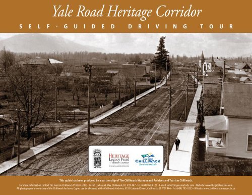
Yale Road Heritage Corridor - Tourism Chilliwack
Yale Road Heritage Corridor - Tourism Chilliwack
Yale Road Heritage Corridor - Tourism Chilliwack

You also want an ePaper? Increase the reach of your titles
YUMPU automatically turns print PDFs into web optimized ePapers that Google loves.
<strong>Yale</strong> <strong>Road</strong> <strong>Heritage</strong> <strong>Corridor</strong><br />
S E L F - G U I D E D D R I V I N G T O U R<br />
This guide has been produced by a partnership of The <strong>Chilliwack</strong> Museum and Archives and <strong>Tourism</strong> <strong>Chilliwack</strong>.<br />
For more information contact the <strong>Tourism</strong> <strong>Chilliwack</strong> Visitor Centre • 44150 Luckakuck Way, <strong>Chilliwack</strong>, BC V2R 4A7 • Tel: (604) 858-8121 • E-mail: info@thegreatoutside.com • Website: www.thegreatoutside.com<br />
All photographs are courtesy of the <strong>Chilliwack</strong> Archives. Copies can be obtained at the <strong>Chilliwack</strong> Archives, 9192 Corbould Street, <strong>Chilliwack</strong>, BC V2P 4A6 • Tel: (604) 795-9255 • Website: www.chilliwack.museum.bc.ca
<strong>Yale</strong> <strong>Road</strong> <strong>Heritage</strong> <strong>Corridor</strong><br />
<strong>Yale</strong> <strong>Road</strong> stretches from one side of <strong>Chilliwack</strong> to the other and<br />
roughly parallels the Trans Canada Highway. Parts of the road<br />
pre-date the 1858 gold rush while other sections were only added in<br />
the 20th century.<br />
A drive along the corridor will take you beside ancient Sto:lo village<br />
and fish processing sites, beside some of the first farms in the area,<br />
and into the heart of the City at Five Corners. Greendale, Cheam and<br />
Rosedale are communities that sprang up in the 19th century that<br />
are also found along the route.<br />
Y<br />
<strong>Yale</strong> <strong>Road</strong>, looking from Five Corners towards Nowell Street, ca. 1920.<br />
(P577, <strong>Chilliwack</strong> Archives)<br />
You can start your drive along the corridor at Rosedale or Greendale<br />
but be sure to time your trip to arrive in downtown <strong>Chilliwack</strong> for a<br />
bite of lunch at one of <strong>Chilliwack</strong>’s many fine restaurants.<br />
Sumas Methodist Church<br />
1886<br />
Sumas Methodist Church,<br />
with <strong>Chilliwack</strong> Mountain<br />
in background.<br />
(P5754, <strong>Chilliwack</strong> Archives)<br />
In 1869 a Methodist Church was built<br />
on <strong>Yale</strong> <strong>Road</strong>, near Atchelitz Creek.<br />
The church, the first in the area, served<br />
the small communities developing at<br />
Sumas (now Greendale), <strong>Chilliwack</strong><br />
and Sardis. By 1882, <strong>Chilliwack</strong> had<br />
its own Methodist Church. Sumas<br />
followed with their own church in 1886.<br />
When services at the church ended in<br />
1971, a succession of owners followed. Finally, in 1996, Henry Meerkerk<br />
purchased the building and over the next five years lovingly restored the<br />
building to its former glory. The building now serves as a wedding chapel<br />
and photography studio.<br />
Y A L E R O A D H E R I T A G E C O R R I D O R Y A L E R O A D H E R I T A G E C O R R I D O R<br />
1
2 Sumas Trunk <strong>Road</strong><br />
High Water Mark 3<br />
1862<br />
1948 Flood<br />
David Miller, and George,<br />
Chester, William and James<br />
Chadsey pre-empted land in<br />
an area that eventually became<br />
the community of Greendale.<br />
Further east, others were settling<br />
on land that would become<br />
the urban core of <strong>Chilliwack</strong>.<br />
Linking the two communities<br />
was a road, the Sumas Trunk<br />
<strong>Road</strong> that eventually became<br />
<strong>Yale</strong> <strong>Road</strong>. From the late 1920s<br />
to 1960, the road served as the<br />
Trans Canada Highway. This<br />
was after Sumas Lake was<br />
drained and it became possible<br />
to build a road across the Sumas<br />
Prairie and before the freeway,<br />
Highway 1, was built.<br />
George Chadsey originally settled<br />
on land adjacent to the Sumas<br />
Trunk <strong>Road</strong> (<strong>Yale</strong> <strong>Road</strong>) in 1866.<br />
(P188, <strong>Chilliwack</strong> Archives)<br />
Aerial view of the Sumas/<br />
Greendale area during the<br />
Fraser River flood of 1948.<br />
(P4512, <strong>Chilliwack</strong> Archives)<br />
On June 1, 1948 at 1:15 in the<br />
afternoon, a break occurred<br />
in the dike that protected the<br />
community of Greendale from the<br />
rising waters of the Fraser River.<br />
Within hours the community was<br />
evacuated and the entire western<br />
half of <strong>Chilliwack</strong> was under water.<br />
The flood was caused by the rapid<br />
melting of snow in the Fraser River<br />
watershed so that the Fraser River was incapable of holding the<br />
water flowing from northern sources. The dikes, originally built in<br />
1900, were in poor condition and in some communities incapable<br />
of holding the floodwaters. For the residents of Greendale, it was to<br />
be months before some were able to return to their homes. Many<br />
lost everything that they owned. After the flood the dikes were<br />
rebuilt and are now capable of withstanding even the severest flood<br />
cycles.<br />
Y A L E R O A D H E R I T A G E C O R R I D O R Y A L E R O A D H E R I T A G E C O R R I D O R
4 Atheléts<br />
Katseslóy 5<br />
“at the creek”<br />
“meeting together”<br />
This village site is occupied by<br />
members of the Athelets band.<br />
Atchelitz Creek meets the old<br />
channel of the <strong>Chilliwack</strong> River<br />
near this site. The rich resources<br />
in the <strong>Chilliwack</strong> area were<br />
heavily used by the Athelets who<br />
were part of the Ts’élxweyeqw<br />
(<strong>Chilliwack</strong>s) tribal group.<br />
At this site, three waterways<br />
joined together, the<br />
Luckakuck, Coqualeetza and<br />
Katseslóy Sly Slough. All three<br />
waterways emptied into the<br />
<strong>Chilliwack</strong> River just north of this<br />
location. The site was a major fish<br />
processing locale as evidenced by<br />
a preponderance of fire cracked<br />
rock - refuse from the old way of<br />
roasting fish over heated pebbles -<br />
found throughout the area.<br />
In 1869, the first church in the area, Atchelitz Methodist Church was built<br />
near this site. (P1464, <strong>Chilliwack</strong> Archives) The Sumas Trunk <strong>Road</strong> connected settlements at Sumas (now called Greendale)<br />
to another small settlement called <strong>Chilliwack</strong> Landing. The road, one<br />
of <strong>Chilliwack</strong>’s oldest, dates to 1862 or earlier. (P1002, <strong>Chilliwack</strong> Archives)<br />
Y A L E R O A D H E R I T A G E C O R R I D O R Y A L E R O A D H E R I T A G E C O R R I D O R
6 Ch’elxwyéqw<br />
“going back upstream; as<br />
far as you can go in canoe”<br />
Jonathan Reece Farm<br />
1862<br />
7<br />
The Sardis area once carried the<br />
main waters of the <strong>Chilliwack</strong><br />
River. A network of sloughs and creeks<br />
fed into the main channel of the river<br />
and all were navigable by canoe only<br />
as far as Vedder Crossing. While the<br />
name <strong>Chilliwack</strong> refers to a place near<br />
Vedder Crossing, as far as you can go<br />
in a canoe, it also refers to the river<br />
and the broader geographical area<br />
that covers most of Sardis. Hudson<br />
Bay Company journals (Fort Langley<br />
Journals, 1827-30, edited by Morag<br />
Maclachlan, UBC Press, Vancouver, 1998) refer to the Chilquihooks,<br />
the aboriginal group who lived in the settlements along the old<br />
channel of the <strong>Chilliwack</strong> River. The main channel of the <strong>Chilliwack</strong><br />
River was diverted into Vedder Creek after 1875 leaving only a small<br />
stream to flow through Sardis and past this point. Various spellings<br />
have been used but the name was<br />
eventually adopted as the name for<br />
the community that became the<br />
City of <strong>Chilliwack</strong>.<br />
<strong>Yale</strong> <strong>Road</strong> at the bridge across the Little<br />
<strong>Chilliwack</strong> River. Before 1875, this<br />
river bed was the main channel of the<br />
<strong>Chilliwack</strong> River. In that year, a log jam<br />
at Vedder Crossing caused its water to<br />
flow in a different direction, reducing<br />
the flow through this channel. (P598,<br />
<strong>Chilliwack</strong> Archives)<br />
Jonathan and Lucinda (nee Lewis) Reece family, ca. 1890s.<br />
Back row, left to right: Flora, Bertha, Edwin, Lena. Front<br />
row, left to right: Lucinda Reece, Elnora “Nora”, and Jonathan<br />
Reece. (P5304, <strong>Chilliwack</strong> Archives)<br />
The 1858 gold rush drew<br />
thousands of gold seekers to<br />
British Columbia. Most passed by or<br />
through <strong>Chilliwack</strong>. A few saw the<br />
opportunities for supplying the gold<br />
seekers with food and supplies. By<br />
1862, Jonathan Reece pre-empted<br />
land on what was then called the<br />
<strong>Chilliwack</strong> Prairie. Natural grasses<br />
and rich soil made this an ideal<br />
location for Reece and his brotherin-law<br />
Isaac Kipp to begin the tradition of farming in <strong>Chilliwack</strong>.<br />
Their two farms, over 800 acres, stretched over most of the western<br />
part of the downtown area and by 1866 were described as the most<br />
advanced farms in the Fraser valley.<br />
Y A L E R O A D H E R I T A G E C O R R I D O R Y A L E R O A D H E R I T A G E C O R R I D O R
8 Five Corners 1873<br />
Sqwá:la 9<br />
“coming out into the open”<br />
Picture postcard view of the second St. Thomas Anglican Church at Five<br />
Corners, as it appeared ca. 1908. (P617, <strong>Chilliwack</strong> Archives)<br />
In 1873, a small settlement, <strong>Chilliwack</strong><br />
Landing, was located at the end of<br />
Wellington Street on the Fraser River.<br />
However, the site was subject to the<br />
flood cycles of the Fraser River and was<br />
surrounded by an established Indian<br />
Reserve. There was limited growth<br />
potential for the small settlement. In<br />
1873, a small handful of Anglicans in<br />
the <strong>Chilliwack</strong> area were anxious to<br />
hold services in their own building. An<br />
abandoned church was found at Port<br />
Douglas at the head of Harrison Lake<br />
and was moved to <strong>Chilliwack</strong> and placed<br />
at the intersection of the Landing <strong>Road</strong> (Wellington) and a new road<br />
that connected <strong>Chilliwack</strong> to New Westminster and <strong>Yale</strong>. The building<br />
was the first to be placed at Five Corners and became the focal point for<br />
the expanding community. Other buildings were constructed around the<br />
intersection and downtown <strong>Chilliwack</strong> was born.<br />
large village settlement was<br />
A once located adjacent to Little<br />
Mountain. When the Sqwá:la<br />
Reserve was established in 1879<br />
there were still people living on the<br />
site. After this date, the remaining<br />
residents moved to the nearby<br />
Skwah Reserve. The aboriginal<br />
group that lived here were members<br />
of the Pilalt tribe. While the Pilalt,<br />
<strong>Chilliwack</strong>s and Teit, who lived<br />
above Rosedale on the Fraser all<br />
spoke Halq’eméylem, variations in<br />
the way words were pronounced led<br />
to the groups being identified by<br />
their dialects.<br />
A crossing, known as the Ford, was located north of this site at Hope<br />
Slough. Before bridges, this was the only way that residents of Fairfield<br />
Island could travel to <strong>Chilliwack</strong>. (P1987.167.18, <strong>Chilliwack</strong> Archives)<br />
Y A L E R O A D H E R I T A G E C O R R I D O R Y A L E R O A D H E R I T A G E C O R R I D O R
10 Sleigh <strong>Road</strong> (Winter only) Meadowlands Golf Course 11<br />
1865<br />
1933<br />
Overhead view of <strong>Yale</strong><br />
<strong>Road</strong> and <strong>Chilliwack</strong><br />
townsite, as seen from the<br />
water reservoir on Little<br />
Mountain, ca. 1907.<br />
(P1987.167.56, <strong>Chilliwack</strong><br />
Archives)<br />
In 1865, construction began on the<br />
Collins Overland Telegraph line. The<br />
line followed an earlier pathway linking<br />
<strong>Chilliwack</strong> to Hope and <strong>Yale</strong>. The road was<br />
only a few feet wide and was impassable<br />
during the winter months. It was upgraded<br />
to wagon road status during the period<br />
from 1873 to 1875. By 1900 parts of the road were paved and <strong>Yale</strong> <strong>Road</strong><br />
became the major highway serving the Fraser Valley.<br />
Aerial view of the Meadowlands<br />
Golf Course, ca. 1936.<br />
(Wells Aero Photo, PColl 42, file 93,<br />
<strong>Chilliwack</strong> Archives)<br />
<strong>Chilliwack</strong>’s first golf course was located<br />
on Fairfield Island and was originally<br />
called the <strong>Chilliwack</strong> Golf Club. The ninehole<br />
course was 3,004 yards in length, had<br />
a right and left hand dog’s leg hole, two<br />
par 2 holes, one of which had a punchbowl<br />
green, two holes with water hazards, and<br />
four holes of over 400 yards in length.<br />
Golf dues were $25.00 for a man and his<br />
wife, $20.00 for a single man, and $10.00<br />
for a single lady, with $5.00 green fees<br />
for all. While this course did not survive<br />
long, a second course, Meadowlands Golf Course, was built in 1933 and is<br />
<strong>Chilliwack</strong>’s oldest established course.<br />
Y A L E R O A D H E R I T A G E C O R R I D O R Y A L E R O A D H E R I T A G E C O R R I D O R
12 Cheam<br />
The Big Ditch 13<br />
1871<br />
1894<br />
Cheam Methodist Church<br />
(right), and the Cheam<br />
Community Hall (left).<br />
(P1183, <strong>Chilliwack</strong> Archives)<br />
East of <strong>Chilliwack</strong> nestled against<br />
Mount Shannon and extending along<br />
<strong>Yale</strong> <strong>Road</strong> beside Hope Slough is the<br />
community of Cheam. Meadowlands<br />
Golf Course, Cheam Elementary School,<br />
and a number of businesses located<br />
at the intersection of <strong>Yale</strong> and Gibson<br />
<strong>Road</strong>s are considered to be within the<br />
boundaries of Cheam.<br />
While the first farms were established in<br />
the 1860s around the Five Corners area,<br />
it wasn’t until the 1870s that the more easterly sections of the community<br />
were settled. The tiny community of Cheam, once heavily forested, was<br />
home to many families whose names are commemorated on local roads.<br />
Early attempts to drain the swamps<br />
and bogs of East <strong>Chilliwack</strong> were<br />
largely limited to localized efforts.<br />
Community wide drainage schemes<br />
did not take shape until after the<br />
1894 flood. East <strong>Chilliwack</strong>, one of the<br />
wetter areas, is today criss-crossed by<br />
a network of ditches, collecting water<br />
from nearby fields or from streams<br />
running off the nearby mountains.<br />
Perhaps the oldest ditch dates to a time<br />
before 1900. The ‘Big Ditch’ runs beside<br />
Upper Prairie <strong>Road</strong> draining areas that<br />
were once bogs and swamps.<br />
East <strong>Chilliwack</strong> Presbyterian Church<br />
was located a short distance south of<br />
the intersection of <strong>Yale</strong> and Upper<br />
Prairie roads, at the corner of <strong>Chilliwack</strong><br />
Central and Upper Prairie<br />
<strong>Road</strong>. Long time residents still refer<br />
to Upper Prairie <strong>Road</strong> as the “Big<br />
Ditch” <strong>Road</strong>. (P6835, <strong>Chilliwack</strong><br />
Archives)<br />
Y A L E R O A D H E R I T A G E C O R R I D O R Y A L E R O A D H E R I T A G E C O R R I D O R
14 Sxelá:wtxw<br />
Sesa:qiwel 15<br />
“marked or painted house” “ice of thunder cracked trees”<br />
Until about 1910, <strong>Yale</strong><br />
<strong>Road</strong> travelled through<br />
the Cheam Indian<br />
Reserve 1907. (P1186,<br />
<strong>Chilliwack</strong> Archives)<br />
large village, complete with<br />
A longhouses for summer use<br />
and pit house sites for winter<br />
use, was located beside <strong>Yale</strong> <strong>Road</strong><br />
on Hope Slough. It was occupied<br />
by the Pilalt who lived along<br />
the sloughs that stretched from<br />
Rosedale to the point where Hope<br />
Slough empties into the Fraser<br />
River.<br />
Sloughs offered protection<br />
and transportation routes for<br />
aboriginal groups living along the<br />
Fraser River. Many of these villages<br />
were abandoned when smallpox<br />
decimated local populations<br />
beginning in 1792.<br />
Like many early roads, <strong>Yale</strong> <strong>Road</strong> followed close to existing waterways such<br />
as Hope Slough. (P5591, <strong>Chilliwack</strong> Archives)<br />
Y A L E R O A D H E R I T A G E C O R R I D O R Y A L E R O A D H E R I T A G E C O R R I D O R
16 Rosedale<br />
Rosedale Ball Park 17<br />
1875<br />
1910<br />
Street level view of the commercial<br />
buildings and businesses in Rosedale,<br />
ca. 1910. Included in the picture is E.<br />
Archibald & Sons, General Merchants<br />
and Stocker & Close general Store.<br />
(P4726, <strong>Chilliwack</strong> Archives)<br />
The completion of the <strong>Yale</strong>-New<br />
Westminster Wagon <strong>Road</strong> in<br />
1873/1874 led directly to the settlement<br />
of Rosedale. J.C. Henderson and T.H.<br />
Henderson acquired land near the<br />
present town site in the early 1880s. A<br />
host of others followed. By 1890, there<br />
were enough families in the area to<br />
warrant building a school. This original<br />
one room school, with fifteen students, was located at the corner of <strong>Yale</strong><br />
and McGrath <strong>Road</strong>s. This corner became the commercial centre of the<br />
community. There have been a variety of businesses located at this busy<br />
corner since the turn of the century, including a bank, stores, restaurants,<br />
garages, rooming house and post office. The corner remains the centre for<br />
the community.<br />
The area’s population boomed beginning in the 1890s. This boom lasted<br />
for more than thirty years, fuelled by the logging, railway and farming<br />
industries. It was a transition period that saw farms replace sawmills.<br />
From 1904 and on, Rosedale<br />
developed a competitive<br />
baseball team. While other<br />
communities had regulation ball<br />
fields, league games in Rosedale<br />
were played on available<br />
pasture lands complete with<br />
animals and stumps. In 1910,<br />
the Rosedale Athletic Club was<br />
formed and one of their first<br />
acts was to acquire a four acre<br />
property for a community ball<br />
park. Except for brief periods,<br />
the Rosedale Athletic Club<br />
cared for the park until 1976<br />
when the <strong>Chilliwack</strong> Parks and<br />
Recreation Department assumed<br />
management of the park.<br />
The Rosedale baseball team finally had their own ball field in 1910<br />
and were able to abandon playing games in farmer’s fields, ca. 1910.<br />
(P4224, <strong>Chilliwack</strong> Archives)<br />
Y A L E R O A D H E R I T A G E C O R R I D O R Y A L E R O A D H E R I T A G E C O R R I D O R
<strong>Yale</strong> <strong>Road</strong> <strong>Heritage</strong> <strong>Corridor</strong><br />
S E L F - G U I D E D D R I V I N G T O U R<br />
1 2<br />
Sumas Methodist Church 1886<br />
Sumas Trunk <strong>Road</strong> 1862<br />
High Water Mark 1948 Flood<br />
Atheléts“at the creek”<br />
Katseslóy “meeting together”<br />
Ch ’ elxwéqw “going back upstream;<br />
as far as you can go in canoe”<br />
3<br />
1 7 Jonathan Reece Farm 1862<br />
2<br />
3<br />
4<br />
5<br />
6<br />
4<br />
8<br />
9<br />
10<br />
11<br />
12<br />
5<br />
7<br />
6<br />
Five Corners 1873<br />
Sqwá:la “coming out into the open”<br />
Sleigh <strong>Road</strong> (Winter only) 1865<br />
Meadowlands Golf Course 1933<br />
Cheam 1871<br />
8<br />
9 10 11<br />
This guide has been produced by a partnership of The <strong>Chilliwack</strong> Museum and Archives and <strong>Tourism</strong> <strong>Chilliwack</strong>.<br />
For more information contact the <strong>Tourism</strong> <strong>Chilliwack</strong> Visitor Centre • 44150 Luckakuck Way, <strong>Chilliwack</strong>, BC V2R 4A7 • Tel: (604) 858-8121 • E-mail: info@thegreatoutside.com • Website: www.thegreatoutside.com<br />
All photographs are courtesy of the <strong>Chilliwack</strong> Archives. Copies can be obtained at the <strong>Chilliwack</strong> Archives, 9192 Corbould Street, <strong>Chilliwack</strong>, BC V2P 4A6 • Tel: (604) 795-9255 • Website: www.chilliwack.museum.bc.ca<br />
13<br />
14<br />
15<br />
16<br />
17<br />
12<br />
13<br />
14<br />
The Big Ditch1894<br />
Sxelá:wtxw “marked or painted house”<br />
Sesa:qiwel “ice of thunder cracked trees”<br />
Rosedale 1875<br />
Rosedale Ball Park 1910<br />
15<br />
17<br />
16