mapping news 30 summer 2006 - Ordnance Survey
mapping news 30 summer 2006 - Ordnance Survey
mapping news 30 summer 2006 - Ordnance Survey

Create successful ePaper yourself
Turn your PDF publications into a flip-book with our unique Google optimized e-Paper software.
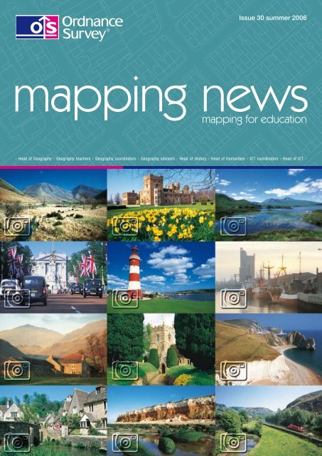
Issue <strong>30</strong> <strong>summer</strong> <strong>2006</strong><br />
<strong>mapping</strong> <strong>news</strong><br />
<strong>mapping</strong> for education<br />
- Head of Geography - Geography teachers - Geography coordinators - Geography advisors - Head of History - Head of Humanities - ICT coordinators - Head of ICT -
Contents and editoral <strong>mapping</strong> <strong>news</strong> <strong>summer</strong> <strong>2006</strong><br />
6<br />
14<br />
40<br />
Information<br />
Free maps for Year 7/Primary 7 pupils<br />
Free maps competition to win a<br />
3<br />
day out with Ray Mears 5<br />
The action plan for geography 6<br />
Is your school worldy-wise? 7<br />
Plymouth High’s geography trip to Ghana 8<br />
Map Pilot 10<br />
Who killed G Joe Raphical?<br />
Discovering Antarctica –<br />
1<br />
a major new online resource 14<br />
New geographic information resource<br />
Resources for looking at<br />
16<br />
our street and our town<br />
Putting geography at the heart of your<br />
17<br />
CPD programme 18<br />
Geograph your area!<br />
Aegis 3 GIS made accessible<br />
Transforming teaching with Anquet<br />
0<br />
<strong>Ordnance</strong> <strong>Survey</strong> software<br />
<strong>Ordnance</strong> <strong>Survey</strong> award for<br />
furthering understanding of<br />
4<br />
children’s geographies 007-08 7<br />
Geography awareness week<br />
The <strong>Ordnance</strong> <strong>Survey</strong> workshop for<br />
8<br />
PGCE trainee geography teachers <strong>30</strong><br />
Box 1, Year 1 use of Aegis 3 on field trip 3<br />
Pointing a way forward for<br />
<strong>Ordnance</strong> <strong>Survey</strong> 33<br />
RGS courses and publications 34<br />
Geodoku 35<br />
Educational software 36<br />
Data supply service 38<br />
<strong>Ordnance</strong> <strong>Survey</strong> Options outlets 39<br />
Where could we take your school? 40<br />
So,<br />
<strong>mapping</strong> <strong>news</strong> Issue <strong>30</strong> Summer 006 www.ordnancesurvey.co.uk/education<br />
are you wondering what the front<br />
page is all about? This is the<br />
fantastic photograph project that is Geograph.<br />
A unique website dedicated to the goal of<br />
building an archive of photographs covering<br />
every square kilometre of the British Isles,<br />
which is free to access! Gary Rogers details its<br />
history and the tie-in with <strong>Ordnance</strong> <strong>Survey</strong>.<br />
Becta and <strong>Ordnance</strong> <strong>Survey</strong> have announced<br />
details of a pilot scheme that will enable all<br />
schoolstohaveeasyaccessto<strong>Ordnance</strong><strong>Survey</strong><br />
digital data. There are several articles inside<br />
that will show you how to use the data within<br />
the classroom.<br />
More good <strong>news</strong>, the free maps for 11-year-olds<br />
scheme will be back for 006–07. This will<br />
be the fifth year of the scheme, which has<br />
seen <strong>Ordnance</strong> <strong>Survey</strong> give away 3. million<br />
OS Explorer Maps. Look out for more details<br />
on our website.<br />
Congratulations to all the winners of both the<br />
Ray Mears Bushcraft free maps competition<br />
and to the free GI software winners.<br />
<strong>Ordnance</strong> <strong>Survey</strong> will be attending two<br />
exhibitions in Scotland: SETT, Glasgow in<br />
September and SAGT, Dundee in October.<br />
Make sure you come along and visit our<br />
stands; we will be pleased to see you.<br />
Hope you all have a great <strong>summer</strong>.<br />
Publishing Editor<br />
Phone: 0 3 8079 975<br />
Fax: 0 3 8079 014<br />
Email: darren.bailey@ordnancesurvey.co.uk<br />
For copyright and general enquiries contact our Customer HelpLine:<br />
Phone: 08456 05 05 05 Welsh HelpLine: 08456 05 05 04 Textphone: 023 8079 2906 (deaf and hard of hearing users only please)<br />
Fax: 0 3 8079 615 Email: customerservices@ordnancesurvey.co.uk Website: www.ordnancesurvey.co.uk<br />
For product advice and to place an order please contact your <strong>Ordnance</strong> <strong>Survey</strong> Options ® network supplier (see page 39).<br />
Designer: Julie Buck-Rogers Phone: 0 3 8079 799 Email: jules.buck-rogers@ordnancesurvey.co.uk<br />
<strong>Ordnance</strong> <strong>Survey</strong>, the OS Symbol, ADDRESS-POINT, Code-Point, Explorer, Land-Line, Landranger, MapZone, <strong>Ordnance</strong> <strong>Survey</strong> Options, OS, OSCAR, OS MasterMap and<br />
TOID are registered trademarks and Boundary-Line, Get-a-map, Integrated Transport Network, OS Select, Our Favourite Places and Street View are trademarks of <strong>Ordnance</strong><br />
<strong>Survey</strong>, the national <strong>mapping</strong> agency of Great Britain.<br />
ArcView and ESRI are registered trademarks of Environmental Systems Research Institute, Inc. BP is a registered trademark of BP plc. Eastenders is a registered trademark of<br />
The British Broadcasting Corporation. GeoMedia and Intergraph are registered trademarks of Intergraph Corporation. Mac OS is a registered trademark of Apple Computer,<br />
Inc. Microsoft and PowerPoint are registered trademarks of Microsoft Corporation. PlayStation is a registered trademark of Kabushiki Kaisha Sony Computer Entertainment<br />
(also trading as Sony Computer Entertainment Inc). Sustrans is a registered trademark of Sustrans Ltd. The Independent is a registered trademark of Independent News and<br />
Media Ltd. University of Bath is a registered trademark of The University of Bath. Verizon is a registered trademark of Verizon Trademark Services LLC. Webraska is a registered<br />
trademark of Webraska Mobile Technologies (sociéte anonyme). Yellow Pages is a registered trademark of Yell Ltd.<br />
Free maps Free maps Free maps Free maps<br />
Free maps for Year<br />
7 / Primary 7 pupils<br />
Happy fifth birthday<br />
We are now entering the fifth year of the scheme and to date a<br />
fantastic 3.2 million Year 7/Primary 7 pupils have received their<br />
free <strong>Ordnance</strong> <strong>Survey</strong> maps throughout Great Britain. By the<br />
end of this year’s scheme this number will have risen to almost<br />
4 million.<br />
Last year there was a total of 736 500 maps sent out to schools in<br />
England, Scotland and Wales, and I hope that all of your Year 7<br />
pupils have benefited. If you need more information about the<br />
scheme or advice on ordering your maps then visit our website –<br />
www.ordnancesurvey.co.uk/freemapsfor11yearolds – where<br />
full details are posted.<br />
The start of the 006 scheme was announced at George Green’s School,<br />
London Borough of Tower Hamlets, by Vanessa Lawrence, Director<br />
General and Chief Executive of <strong>Ordnance</strong> <strong>Survey</strong>, with Parliamentary<br />
Under-Secretary of State for Employment Relations and Minister for<br />
London at the Department of Trade and Industry Jim Fitzpatrick.<br />
Left to right: Vanessa Lawrence, Director General and Chief Executive <strong>Ordnance</strong> <strong>Survey</strong>,<br />
Kenny Frederick, Principal George Green’s school, Jim Fitzpatrick, Parliamentary<br />
Under Secretary of State for Employment Relations and Minister for London at the<br />
Department of Trade and Industry<br />
Pupils at George Green’s School on the Isle of Dogs heard the<br />
announcement at the start of a geography lesson combining map and<br />
computer skills with local knowledge. Principal Kenny Frederick, a<br />
geographer, says:<br />
‘This is an excellent initiative from <strong>Ordnance</strong> <strong>Survey</strong>, offering<br />
a practical and relevant resource for teaching and learning.<br />
By understanding the concept of location, pupils can begin<br />
to explore the links between the environmental, social and<br />
economic issues which shape the world.’<br />
Roger Jeans, Education Manager<br />
After the initial launch formalities, geography<br />
teacher Neal Long led a really absorbing<br />
lesson using the free maps on a theme of a<br />
treasure hunt, using many local photographs,<br />
identifying their positions on the map and then<br />
working out the grid references.<br />
Staff from <strong>Ordnance</strong> <strong>Survey</strong> that attended<br />
the launch were each allocated a table with a<br />
group of pupils, who quickly accepted them<br />
to the group. The room was buzzing as each<br />
group raced each other to complete each task.<br />
We were all extremely impressed by the way<br />
the pupils threw themselves into the challenge<br />
and how good their map-reading skills are.<br />
Vanessa’s group<br />
Scott’s group<br />
www.ordnancesurvey.co.uk/education <strong>mapping</strong> <strong>news</strong> Issue <strong>30</strong> Summer 006 3
Free maps Free maps Free maps Free maps<br />
Roger’s group<br />
Geoff’s group<br />
It proved to me how well pupils can understand<br />
the maps and recognise features from their local<br />
area. After half an hour, with the lesson drawing<br />
to a close, Neal consolidated what had been<br />
learned and many pupils were keen to show<br />
what they knew. A big thank you goes to Principal<br />
Kenny Frederick for inviting us to the school.<br />
It was interesting to note that many children<br />
who entered the 005 free-maps competition<br />
to win a day out with Ray Mears commented<br />
on how big the map they received was. Well, as<br />
you can see from the picture below, it certainly<br />
is a big piece of paper! Each map covers at<br />
least 600 sq km ( <strong>30</strong> sq miles) of land at a<br />
scale of 1: 5 000, and every Year 7 pupil can<br />
get their one totally free!<br />
The 006 scheme will be open for schools to<br />
order their maps in early August for Scottish<br />
Primary 7 pupils and in September for English<br />
and Welsh Year 7 pupils. All eligible schools will<br />
receive a letter that contains their user name and<br />
password for ordering the maps online at those<br />
times. So keep your eyes open and order as soon<br />
as possible once you get your letter to ensure<br />
that your pupils receive their free map as early as possible. Please note that<br />
until you receive your letter you will not be able to order any maps.<br />
Please be aware that in ordering the maps you are agreeing to distribute<br />
them to the pupils at Year 7; they are not the property of the school<br />
although teachers’ maps are included in the ratio of one teacher’s map<br />
for every 5 pupils’ maps ordered.<br />
It has been brought to our attention that a few schools have not<br />
distributed the maps to the pupils. Unfortunately, this jeopardises the<br />
continuation of the scheme for all schools, so please ensure that the<br />
pupils at your school do receive their maps.<br />
Free maps to remain<br />
in Primary 7 for<br />
Scottish schools<br />
Free maps have always been distributed to Year 7s in England and<br />
Wales and Primary 7 in Scotland. However, at the SAGT conference in<br />
Dundee, representations from some Scottish secondary schools led to<br />
<strong>Ordnance</strong> <strong>Survey</strong> undertaking a further survey in 005 to explore whether<br />
this was the best placement year for the maps. The results were clear,<br />
with 93% of primary schools wanting the maps to continue to be given<br />
to Primary 7s and 9 % of secondary schools wanting the maps to be<br />
distributed to S1s. The HM Inspectorate (HMI) for Geography in Scotland<br />
was asked to provide a definitive answer to this problem and, after further<br />
investigation, it was agreed to leave the map distribution at Primary 7.<br />
Reasons include:<br />
• It being felt that Primary 7 was the optimum time to develop <strong>mapping</strong><br />
skills.<br />
• Distribution at primary level gives a greater likelihood that a pupil’s<br />
home and school will both be on the map (known to provide far<br />
greater engagement for the pupils). Travel to school distances for<br />
secondary pupils tends to be greater in Scotland than in England and<br />
Wales, so this reason carries greater weight for Scottish pupils.<br />
• Many primary schools have developed extensive new teaching<br />
resources based on the expectation that they would continue to<br />
receive the free maps.<br />
<strong>Ordnance</strong> <strong>Survey</strong> has agreed to:<br />
• provide a checklist of map skills that all primary pupils should<br />
acquire by the end of Primary 7 so that S1 teachers will have an<br />
assurance that all pupils are at the same level;<br />
• provide online access to schools sign-up information so that all<br />
secondary schools can see if their feeder schools have ordered<br />
maps to promote this facility to them; and<br />
• increase promotion of the scheme to Scottish primary schools to<br />
ensure maximum take-up.<br />
Having undertaken this extensive consultation, the decision to leave<br />
free maps in Primary 7s must now be considered as final. Thank you to<br />
all 490 Scottish schools who took part in the survey.<br />
4 <strong>mapping</strong> <strong>news</strong> Issue <strong>30</strong> Summer 006 www.ordnancesurvey.co.uk/education<br />
Free maps Free maps Free maps Free maps<br />
Free maps competition<br />
to win a day out with<br />
Ray Mears<br />
We had a fantastic response for this<br />
competition and received over 3 000 entries.<br />
It has taken a while to read all the entries<br />
and it was good to note that the pupils were<br />
each pleased to receive their map and the<br />
enthusiasm they have shown in getting good<br />
use from it.<br />
It is obvious from the entries that pupils have used their map to<br />
discover many new things about their area such as ‘the Preseli<br />
Blue stones that were used to build Stonehenge’, ‘remains of<br />
Iron Age settlements’, ‘new routes to school’ and ‘pathways<br />
for undiscovered walks’. Some considered the effects of global<br />
warming and used the contours to establish what the rise of sea<br />
level would mean to their area, and many hundreds of pupils<br />
commented on the comparative size of features such as woods and<br />
forests compared with built-up areas.<br />
The standard of entries was very high and it was an extremely difficult job to select the winners. The twelve winners will be<br />
contacted and the runners-up will receive their prizes through the post. A full list of winners can be viewed on our website<br />
at www.ordnancesurvey.co.uk/education.<br />
Well done to all who entered and congratulations to the winners. Make sure<br />
your pupils enter this year’s competition to win a day out with the Time Team!<br />
Free software competition – win a copy of GI software<br />
In the GIS for schools booklet that was included with the last edition of <strong>mapping</strong> <strong>news</strong>, we ran a competition to win a<br />
copy of each of the GI packages that were reviewed. After trawling through the many entries, the following schools were<br />
the lucky winners:<br />
Scalford Primary CE School – Melton Mowbray<br />
Chilwell School – Chilwell<br />
Manorfield CE Primary School – Stoney Stanton<br />
Chichester High School for Boys – Chichester<br />
Smestow School – Wolverhampton<br />
Verdin High School – Winsford<br />
St Teath School – St Teath<br />
Benfield Junior School – Portslade<br />
Downside School – Radstock<br />
Helston Community College – Helston<br />
Upavon School – Pewsey<br />
www.ordnancesurvey.co.uk/education <strong>mapping</strong> <strong>news</strong> Issue <strong>30</strong> Summer 006 5
The action plan for<br />
geography<br />
The Geographical Association (GA) is thrilled to be working in close partnership with the Royal<br />
Geographical Society with the Institute of British Geographers (RGS-IBG) on a programme<br />
called Geography in Action. This was launched with considerable fanfare and flourish at the<br />
RGS-IBG on <strong>30</strong> March – with Michael Palin leading the way. His book Himalaya will find its<br />
way into secondary schools with a letter from the Minister for Schools, Lord Andrew Adonis,<br />
anticipating the recovery and resurgence of geography in schools.<br />
You can find more details about the Action Plan on the web. This article is going to<br />
focus mainly on one element of the plan, namely the need to promote and support<br />
‘subject leadership’ in schools.<br />
Geography: making connections<br />
David Lambert<br />
The launch of Geography in Action was reported in The Independent ® <strong>news</strong>paper.<br />
Perhaps unsurprisingly, this article focused (yet again) on geography’s challenging<br />
circumstances in schools – declining numbers at GCSE and A level, poor Ofsted<br />
reports in primary and KS3 and so on.<br />
But the article also made a link to The<br />
Independent’s ground-breaking theme<br />
for the week: ’Your world. Your<br />
say’ – a forum of letters and comment<br />
about global warming. Furthermore, I<br />
couldn’t help but notice that the front<br />
page of the paper that day was covered<br />
in maps (of the Middle East).<br />
There is no doubt about it. Geography<br />
is a 21st-century subject. It concerns<br />
the future, as well as the past and<br />
present. Without geography you<br />
may be limited in your ability to<br />
read The Independent,(or watch<br />
the six o’clock <strong>news</strong> for that<br />
matter). Geography provides the<br />
learner with an appreciation of the<br />
interconnectedness of the world and<br />
the various issues and challenges<br />
that lie ahead, and the means to think confidently about the future – something a<br />
professor of geography was urging as a priority.<br />
‘Why isn’t climate change… the core subject of our schools…?’<br />
Nicki Penaluna<br />
‘I have read little about scenarios that may lie ahead (about 50 years)’<br />
Prof R Bradshaw, Dept of Geography, Liverpool<br />
‘Although I am only 14-years-old I believe my opinion can make a<br />
difference. So here goes…’ Helen Way<br />
‘People must make informed choices…’ A-level geography class<br />
(Quotes from the Your world. Your say forum from The Independent on the <strong>30</strong> and 31 march.)<br />
6 <strong>mapping</strong> <strong>news</strong> Issue <strong>30</strong> Summer 006 www.ordnancesurvey.co.uk/education<br />
The GA’s contribution to Geography in Action is to<br />
emphasise subject leadership. No matter how much<br />
we love geography and enjoy the wow! factor of<br />
special places, we need to be clear about how to select,<br />
organise and sequence wonderful learning experiences<br />
for children, with a clear sense of how and why it is<br />
relevant to their education.<br />
Perhaps, ‘to be able to read the <strong>news</strong> intelligently’<br />
just about covers everything. In fact, Rita Gardner<br />
(the Director of the RGS-IBG) and I will be devoting<br />
considerable energy to clarifying an overarching<br />
framework for school geography – in our capacity of<br />
Geography Advisers to the Secretary of State.<br />
We will want to show how geography can switch on<br />
curiosity about the world, open eyes and encourage<br />
the exploration of diverse people and places, establish<br />
aspects of geographical capability to operate<br />
confidently with knowledge and understanding about<br />
the physical and human worlds, and the skills of<br />
informed and aware citizens.<br />
Subject leadership operates at all levels, and within<br />
the shared framework all teachers will need support<br />
and encouragement to do their bit – the selection,<br />
organisation and sequencing of geography curricula.<br />
This is what we mean by curriculum making<br />
– so watch out for courses, publications, and online<br />
opportunities, literally to lead geography closer to the<br />
centre ground of the curriculum!<br />
The GA will have dedicated primary and secondary<br />
teams to offer subject leadership CPD (continuing<br />
personal development) and curriculum development<br />
opportunities. In addition, we will be rolling out the<br />
Primary and the Secondary Geography Quality Marks<br />
from September <strong>2006</strong>.<br />
Is your school<br />
worldy-wise?<br />
The Geographical Association’s (GA) Worldwise initiative enables young<br />
people to take part in fun and engage in free activities to promote geography<br />
in schools.<br />
With opportunities to take part at both a local and national level, the project<br />
culminates in the annual Worldwise challenge, a weekend of free fieldwork<br />
activities. <strong>Ordnance</strong> <strong>Survey</strong> has hosted the Hampshire round of the<br />
competition for more than two decades and is one of the main sponsors with<br />
ESRI ® UK and the Field Studies Council.<br />
The head of geography at King Edward VI’s school in Southampton, Mr Garry<br />
Hunt, has been involved in Worldwise since 1983.<br />
He recalls:<br />
‘At that time the event was run in Southampton by the local<br />
branch of the GA and it took place at, what was then, the<br />
Curriculum Development Centre in the city. Sponsorship<br />
has been a key element, and during my second year of my<br />
involvement I invited <strong>Ordnance</strong> <strong>Survey</strong> to attend, resulting in an<br />
offer to host the following year’s event.’<br />
‘At one stage there was a regular series of rounds, starting at a local level in December.<br />
Then there was a regional final, which took place in February, followed by a national<br />
final, which was normally tied into the GA conference at Easter. One year there<br />
was even an international final based on taking one team member from each team<br />
competing in the national event. King Edward VI was fortunate enough to come second<br />
nationally that year, and I can still remember the agony of trying to decide which one of<br />
our team members should get an all-expenses paid trip to America.’<br />
‘The quiz today is a rather different animal. There is now only a<br />
local round to the quiz, which I feel is a shame in many respects.<br />
There are, however, other elements – which include various<br />
online activities and competitions – that no doubt appeal to a<br />
wider audience and are more accessible. The Field Study Council<br />
sponsors the winner’s visit to Malham Tarn Field Centre.’<br />
‘The children that I know enjoy taking part in the event and staff<br />
are often very pleasantly surprised by the level of knowledge<br />
demonstrated by their students. I have enjoyed my involvement in<br />
the quiz and have been fortunate to work with many like-minded<br />
individuals. Having <strong>Ordnance</strong> <strong>Survey</strong> as hosts has made<br />
organising the quiz much easier and has given the Southampton<br />
area an independent base from which to run it. This has helped<br />
to make it such a successful event.’<br />
All secondary schools are eligible to enter teams for the local round of the<br />
quiz. Each team is made up of three pupils who must all be under 16 on 1<br />
September of the year of entry.<br />
For more information visit http://www.geography.org.uk/events/worldwise<br />
www.ordnancesurvey.co.uk/education <strong>mapping</strong> <strong>news</strong> Issue <strong>30</strong> Summer 006 7
Plymouth High’s Geography Department<br />
has been using GIS in a very simple way<br />
for some years but has decided it is time<br />
to move things up a bit. Pat Frean will be<br />
taking a group of pupils to Ghana; here she<br />
writes about the forthcoming project.<br />
Pat Frean<br />
Geography AST, Plymouth High School for Girls<br />
I am taking a group of 8 Year 1 geography students to visit our partner school in Ghana for a week<br />
in June. We are going to do fieldwork with eight students from Ahantaman Senior Secondary<br />
School in Sekondi-Takoradi and we are going to need a decent map, particularly as there are no<br />
addresses for particular buildings; post office boxes are used.<br />
Whilst we are there, our School Network Manager is aiming to network the school and bring in<br />
broadband. If successful, this will mean that Ahantaman can be a communication hub for all the<br />
local schools that have partner schools in Plymouth.<br />
Sekondi-Takoradi is a city of about 50 000 population, similar to that of Plymouth. Like Plymouth,<br />
it is a naval port and it is about the same travelling time from the capital – Accra – as Plymouth is<br />
from London. We chose each other as partner cities partly because of these similarities. I want<br />
my students to look for similarities and differences too, and on at least one of the days we will be<br />
looking at land-use patterns in Sekondi-Takoradi.<br />
With great anticipation I looked up Sekondi-Takoradi on Google Earth – nothing there really.<br />
There isn’t enough information and the picture pixilates as you zoom in. We have a simple poster<br />
map of Ghana that I picked up in Accra last year and I bought a map of Ghana from Stanfords,<br />
but I don’t have decent street map of Sekondi-Takoradi. The Japanese have surveyed Ghana and<br />
have produced excellent quality large-scale maps of the country but there still isn’t anything I<br />
can find that resembles a street map of the town.<br />
The Ghana: The Bradt Travel Guide, which I bought before last year’s trip, has a reasonable<br />
street map of Takoradi, so that seems a good place to start. The students will be set the task<br />
8 <strong>mapping</strong> <strong>news</strong> Issue <strong>30</strong> Summer 006<br />
www.ordnancesurvey.co.uk/education<br />
of taking digital photographs in strategic places around the market circle and along streets radiating out from there.<br />
They will need to record very carefully where they are standing and where they are facing. This seems an ideal project<br />
for English and Ghanaian students to undertake together. We will take a digital video camera and digital sound recording<br />
machine. If we are very lucky we will attain permission from the local airfield for the air force to take us up for a fly-over of<br />
the city, since there are not really any tall buildings from which to gain a good view.<br />
Once we have collected all of our data, the plan is to put hyperlinks into the map in the Local Studies package to make<br />
it interactive. If we can manage to take a laptop with us we will be able to do this with our Ghanaian counterparts, which<br />
will mean we are less likely to make mistakes and match the photos with the wrong locations. We should then have<br />
several camera icons to click on for still photos, at least one video clip of an aerial view of the city, plus sound files of the<br />
marketplace, the seafront, the school and so on.<br />
If we are successful, we will be able to make the files available to all the schools in Plymouth that have links with<br />
Sekondi-Takoradi schools, as long as they have the basic Local Studies package.<br />
Following this we hope to raise sufficient funds to bring a small group of Ahantaman students to Plymouth for fieldwork<br />
in 007. We should be able to do the same activity with a street map of Plymouth and the Local Studies package so<br />
that students in Sekondi-Takoradi will be able to see what Plymouth is like when it is their turn to access the Internet at<br />
Ahantaman’s Centre for Skills Acquisition.<br />
www.ordnancesurvey.co.uk/education<br />
<strong>mapping</strong> <strong>news</strong> Issue <strong>30</strong> Summer 006 9
Becta has been working with <strong>Ordnance</strong> <strong>Survey</strong> for the<br />
last few months on developing an initiative for making<br />
<strong>Ordnance</strong> <strong>Survey</strong> digital map data more accessible<br />
to schools. This work is part of broader Becta activity<br />
to provide improved access to digital resources for<br />
e‑learning. A pilot map‑data service is now under trial.<br />
The trial is being jointly managed by the Advisory Unit Computers in<br />
Education (a school GIS software company) and eMapSite (map-data<br />
delivery specialists) and will have two main outcomes.<br />
1 Improved access to map data for schools through<br />
suppliers’ products<br />
A number of <strong>Ordnance</strong> <strong>Survey</strong> map-data products (for example,<br />
OS MasterMap ® ) will be held centrally for the whole of England,<br />
Scotland and Wales, so school suppliers who use map data within<br />
their educational products will have easier access to it and can satisfy<br />
school requirements. Importantly, there will be no charge to suppliers<br />
who want to take map data to add to their products, provided that these<br />
are restricted to school use. This will make it easier for suppliers to<br />
create teaching and learning resources for schools, which in turn will<br />
make it easier for schools, who won’t necessarily have to load map<br />
data into computer packages themselves.<br />
10 <strong>mapping</strong> <strong>news</strong> Issue <strong>30</strong> Summer 006 www.ordnancesurvey.co.uk/education<br />
The free use of map data in suppliers’<br />
educational products will be permitted for<br />
the duration of the trial, and, assuming this<br />
is successful, extended into a full service to<br />
be delivered through the National Education<br />
Network (NEN). Schools should therefore<br />
expect to see a greater choice of resources<br />
with map-data content available in the near<br />
future.<br />
2 Understanding the benefits of teaching with digital map<br />
data<br />
The trial also involves working with a number of schools to address key<br />
questions about the use of digital map data for teaching and learning.<br />
These include:<br />
• establishing which <strong>Ordnance</strong> <strong>Survey</strong> datasets will be most useful<br />
for schools;<br />
• exploring the data formats, standards and specifications required<br />
for a range of services, including data download and web services;<br />
• scoping and testing data security in schools (authentication); and<br />
• investigating the educational benefits of different options.<br />
Once these issues are understood then a map-data delivery specification<br />
can be drawn up for delivery of data to all schools through the future<br />
NEN.<br />
We are looking for a number of schools that are interested in working on<br />
the pilot. These schools need to have strong geography departments<br />
and have some experience of using digital map data, and probably<br />
some ideas for which they need greater access to data to fulfil.<br />
We still have some vacancies for schools to take part in the trial, so if<br />
your school is already successfully using <strong>Ordnance</strong> <strong>Survey</strong> map data<br />
for teaching and learning we are interested in hearing from you. Please<br />
send a brief email to mappilot@becta.org.uk<br />
Map data on the web<br />
It is already clear that delivery of map data via web services has a<br />
number of attractions for schools. These include the fact that schools<br />
do not have to store or locally handle raw data themselves and the ease<br />
with which teaching materials can be delivered alongside the <strong>mapping</strong>.<br />
The pilot will investigate some schemes already available to schools in<br />
some locations and will aim to provide some examples that all schools<br />
will be able to use.<br />
Trial report<br />
The trial is expected to report in <strong>summer</strong> 007; look out for further<br />
reports in <strong>mapping</strong> <strong>news</strong>.<br />
Questions<br />
Will I still be able to get digital map data from my local authority (LA)?<br />
Yes: any service provided to schools during the trial, or subsequently<br />
developed, will have no effect on the supply of <strong>Ordnance</strong> <strong>Survey</strong><br />
map data supplied directly from LAs. Some LAs have very advanced<br />
data‑delivery services for their schools. However, others have been<br />
unable to develop a service. The option of taking data directly from a<br />
Becta‑managed service will simply provide more choice for schools.<br />
I am an independent school and currently obtain data from ESRI ® Maps<br />
Direct. What will happen to this service?<br />
This service will continue for the duration of the trial, and we are<br />
reviewing the data products available within it to ensure that they<br />
complement the trial.<br />
www.ordnancesurvey.co.uk/education <strong>mapping</strong> <strong>news</strong> Issue <strong>30</strong> Summer 006 11
G Joe Raphical was brutally<br />
murdered after enjoying a quiet<br />
drink in the Swallow Falls public<br />
house, outside the village of<br />
Betws-y-Coed, on Tuesday <strong>30</strong><br />
April at around 8.15 pm. He was<br />
aged 28 and single, and believed to be<br />
a visitor from the West Midlands area.<br />
He was dead within seconds of being<br />
attacked and his body was dumped in<br />
the river; a post-mortem revealed two<br />
slash wounds to the chest and that he<br />
had been in the river for two hours.<br />
The question is, who killed him?<br />
In a dual attempt to boost<br />
numbers around options time,<br />
and also to encourage the<br />
gifted and talented in our school<br />
to see that geography was not<br />
just about processes and places,<br />
I devised a murder weekend for a<br />
group of Year 9 pupils.<br />
The theme of the weekend was the<br />
detection of who, where and why did a<br />
young geographer called G Joe Raphical die<br />
on holiday in Snowdonia National Park. This<br />
was linked to units delivered in the autumn term<br />
(crime in the community and National Parks).<br />
What did they do?<br />
We used the Wolverhampton Outdoor<br />
Education Centre (OEC) at Capel Curig as our<br />
base for the weekend trip. After departing the<br />
school at 5 pm on a snowy January Friday<br />
evening, the pupils were briefed as to what<br />
they had to do over the next 48 hours.<br />
They were given the victim’s name, which<br />
brought roars of derision about my sense of<br />
humour. Then they were given the six suspects’<br />
names (many thanks to the Staffordshire<br />
Learning Network Geography website for<br />
these). With the money from the RGS award,<br />
we were able to use new analytical instruments<br />
for soil analysis and create 60-second video<br />
diarys, which were played, to hoots of laughter,<br />
on Friday. (Thanks to the members of staff who<br />
were pretending to be each of the suspects.)<br />
Friday evening<br />
On arrival at the centre the pupils were split into six groups/<br />
teams for the weekend, each having to come up with their own<br />
detective names. After settling, we went to the classroom, where I<br />
had set up the first pieces of evidence. This took the form of six pairs<br />
of shoes (many thanks to colleagues who donated unwanted footwear)<br />
each filled with soil. These were the suspects’ shoes, which the pupils<br />
were to compare with the<br />
sample they already had<br />
taken from the victim’s shoes.<br />
I had already prepared at<br />
school three basic types of<br />
soil – one sandy, one clay and<br />
the last one loam – by mixing<br />
my garden soil with varying<br />
percentages of sand.<br />
The pupils were then given a suspect each and had to analyse the soil<br />
using the settling technique outlined in the booklet. They then left these<br />
to settle out overnight.<br />
After the soil testing the centre staff took the pupils out for a night walk,<br />
which, after the long school day and journey, was enough to get them<br />
to bed quickly and quietly.<br />
Saturday morning<br />
After checking their soils sedimentation experiments, and interpreting the<br />
soils using a triangular graph of soil compositions, the teams were ready<br />
for the next crime scene. Each team was given a map extract showing a<br />
route along a local river and the location of where G Joe Raphical’s body<br />
was found. They were<br />
sent out along the<br />
route at timed intervals<br />
and had to use map<br />
skills/orienteering to<br />
find the location on<br />
the river bank where<br />
the body was found.<br />
This was executed so<br />
enthusiastically that<br />
teams were finding and<br />
recording clues even<br />
when there were none!<br />
Once at the location on the river, the teams were given a<br />
stopwatch, 10-m length of rope and a tennis ball. They had<br />
10 minutes to devise a method of measuring the velocity of the<br />
stream using these tools (no prompting was given by staff, but lots of<br />
hints about Year 7 river study fieldwork were dropped). Once they had<br />
devised their method they repeated it three times to get an average<br />
speed, then velocity.<br />
That afternoon we were taken on outdoor pursuits by the OEC staff to<br />
allow team building and plots to thicken.<br />
Saturday evening<br />
After a good day’s sleuthing<br />
in the river, the teams were<br />
given time in the evening to<br />
compare their soil findings<br />
with those of the victim and<br />
also used their river velocity<br />
measurements, along with<br />
a local <strong>Ordnance</strong> <strong>Survey</strong><br />
map, to figure out where<br />
the body entered the river.<br />
How? They had an autopsy report that said the victim was in the water<br />
for two hours, so by some simple numeracy skills they could calculate<br />
the distance travelled at the velocity they recorded. Once the distance<br />
had been plotted on the <strong>Ordnance</strong> <strong>Survey</strong> map back upstream, they<br />
could see which of the suspects’ houses (conveniently four of the<br />
suspects lived by the river) were closest to the entry point of the body<br />
to the river. We went to bed mentally and physically tired but ready for<br />
the final day and the who dun it?<br />
Sunday morning<br />
The teams were informed after<br />
breakfast that one of the suspects had<br />
tried to flee in the night, but fortunately<br />
for us the final pieces of evidence<br />
had been blown away in a local wood<br />
(and oh so conveniently the pieces of<br />
evidence happened to coincide with<br />
an orienteering course set out by the<br />
OEC staff). So the teams were issued<br />
with <strong>Ordnance</strong> <strong>Survey</strong> maps and<br />
Geographical murder mystery in north Wales<br />
Developed by Anthony Cheetham<br />
Head of Geography & Environmental Science<br />
Highfields Science Specialist School<br />
WOLVERHAMPTON<br />
checkpoints and set off on an orienteering<br />
course to collect as much evidence as they<br />
could in two hours. After a few red faces<br />
from certain teachers when one group had<br />
to be reminded of what the blue lines on the<br />
map were for, all the teams engaged and ran<br />
themselves into the ground.<br />
Back at base they were showered and fed<br />
and then given one hour to put together their<br />
interpretation of who, what, where and why.<br />
In conclusion, it took a lot of work to set up and<br />
with the help of my department – Rachel Cutter;<br />
Jodie Mills and Laura Tunstall – and Highfields<br />
Science Specialist School along with the staff<br />
at The Towers OEC, Capel Curig, it has been a<br />
worthwhile project. We now use it regularly in<br />
the <strong>summer</strong> term as a reward for those pupils<br />
who have<br />
worked hard<br />
during the<br />
year; we<br />
have had<br />
requests<br />
from<br />
parents to<br />
participate.<br />
In terms of impact on the subject, it has raised<br />
the profile of the department with parents and<br />
governors, senior leadership of the school and<br />
the wider community through media and joint<br />
ventures with other schools. For next year<br />
we are developing a locally based murder<br />
mystery, which will allow us to invite parents<br />
along with their children to learn or practise<br />
map skills and use the free <strong>Ordnance</strong> <strong>Survey</strong><br />
maps that the Year 7 students receive.<br />
1 <strong>mapping</strong> <strong>news</strong> Issue <strong>30</strong> Summer 006 www.ordnancesurvey.co.uk/education www.ordnancesurvey.co.uk/education <strong>mapping</strong> <strong>news</strong> Issue <strong>30</strong> Summer 006 13
Discovering Antarctica –<br />
a major new online resource<br />
A major new educational online resource, launched at the<br />
Antarctic Treaty consultative meeting in Edinburgh<br />
in June, has been developed by the Royal Geographical<br />
Society with the Institute of British Geographers (RGS-<br />
IBG) in partnership with the British Antarctic <strong>Survey</strong><br />
(BAS) funded by the Foreign and Commonwealth Office<br />
(FCO).<br />
This exciting and innovative new site can be found at<br />
www.discoveringantarctica.org.uk. Primarily for teachers of<br />
Key Stage 3, it provides online interactive resources that could be<br />
used on an interactive whiteboard or in the computer suite. Each<br />
section features activities, images, video clips and activity sheets<br />
to help pupils learn about this distant, frozen wilderness. There are<br />
also downloadable resources to be used in the classroom without<br />
involving the use of ICT.<br />
Teachers and learners are invited to take a journey through<br />
Antarctica; a frozen, windswept continent, so hostile and remote<br />
that it has no permanent inhabitants. Scientists working there<br />
have made many discoveries from studying Antarctica’s land<br />
and atmosphere, and from clues buried beneath the ice. These<br />
discoveries also reveal warning signs of changes in the future<br />
that could affect us all. The site is divided into 10 learning areas.<br />
From Imagining Antarctica through to the first Journeys South<br />
to Living There Now; the importance of the Antarctic Treaty is<br />
examined and pupils can investigate the fact that Antarctica is<br />
Under Pressure and speculate about The Future of the continent.<br />
The Changing Climate is explored, looking at ways in which what<br />
we do in our daily lives can affect the climate of Antarctica.<br />
Pupils discover where Antarctica is, what it is like and why<br />
Antarctica is as it is. They can find out cool facts about the continent.<br />
Icebreaker activities can be used at the start of the lessons; these<br />
include a wilderness challenge and finding out why tourists go<br />
there. Who’s looking at you? examines the ecosystem beneath<br />
the waves: Antarctica’s landscape is far too harsh to support much<br />
life; conditions for living things are far better in the surrounding<br />
ocean. Although the water is very cold, the temperature doesn’t<br />
change much during the year, and the water is rich in nutrients.<br />
The main body of the activities, when pupils Go with the Floe,<br />
include making a trailer for Antarctica the movie. There is an<br />
enquiry about the use of resources with a choice between either a<br />
focus on fish or bioprospecting. The latter is a new area of science<br />
14 <strong>mapping</strong> <strong>news</strong> Issue <strong>30</strong> Summer 006 www.ordnancesurvey.co.uk/education<br />
that people have called ‘the gold rush of the 1st century’. The<br />
exploration of Antarctica past and present is examined through the<br />
Rime of the Ancient Mariner and the story of the race to the<br />
Pole at the start of the 0th century, while the sort of clothing and<br />
equipment necessary to survive in Antarctica are discussed.<br />
Meltdown activities conclude the lessons. For example, pupils are<br />
encouraged to investigate the ways in which people from different<br />
countries worked together in Antarctica. They can complete a form<br />
to apply for the job of a lifetime – a 1 -month posting to the Halley<br />
VI research station – but they have to consider life without fast<br />
food, Eastenders ® or a PlayStation ® ! Finally, they can report on the<br />
future of the continent by looking at two different scenarios. In the<br />
first Antarctica is used to make money by exploiting its resources;<br />
the second is to keep it as a world park for scientific research.<br />
The site has had an enthusiastic response from the teachers who<br />
have reviewed it:<br />
‘There are loads of useful information and<br />
interesting activities. Great stuff!’<br />
‘The world upside down is a great resource.<br />
The trick question even got me fooled<br />
for a short while.’<br />
‘Movie planning is a really interesting idea.<br />
The sounds are wonderful and easy to access.’<br />
Local learning through GIS<br />
This is the planned third stage of the strategic programme of online<br />
geographical information system (GIS) support developed by the<br />
RGS-IBG through the Use of GIS in teaching geography project<br />
available at www.rgs.org/education; the previous two stages<br />
being Getting Started in GIS and Embedding GIS in secondary<br />
geography, with its series of software evaluations and exemplars.<br />
This project supplies teachers with easily accessible resources<br />
such as data as well as case studies.<br />
Learning about your local area lies at the very heart of geography,<br />
but in the past has been difficult to deliver owing to limited access<br />
to data sources and linked <strong>mapping</strong> activities. This has recently<br />
changed with the advent of a combination of GIS, new and free<br />
data sources, and easier access to downloading data from the<br />
Internet. An understanding of the local area can motivate pupils<br />
and the ease of access to data means they can work at their own<br />
pace. Geographic data and information changes over time, and<br />
this provides for up-to-date resources. Much of the fieldwork<br />
and out-of-classroom learning undertaken by pupils in schools<br />
concerns their local area, and the outcomes of this project will<br />
provide a further valuable resource to enhance the attainment of<br />
young people.<br />
www.ordnancesurvey.co.uk/education <strong>mapping</strong> <strong>news</strong> Issue <strong>30</strong> Summer 006 15
New geographic<br />
information resource<br />
Memory-Map has released a teacher’s<br />
resource pack that can be incorporated in<br />
geography lessons and teaches key skills in<br />
the curriculum.<br />
The pack contains information sheets and<br />
worksheets for Key Stage 3 and GCSE, and<br />
covers topics such as:<br />
• Map skills<br />
• Settlements<br />
• Tourism<br />
• Coasts and industry<br />
There is also a CD that includes copies of all the<br />
worksheets from the teacher’s resource pack<br />
and a <strong>30</strong>-day free trial of the Memory-Map<br />
software.<br />
The resource pack has been designed to<br />
be used with Memory-Map software and<br />
<strong>Ordnance</strong> <strong>Survey</strong> digital data to enhance<br />
the use and understanding of geographic<br />
information within the classroom.<br />
David Rayner, geography teacher for Grammar School<br />
for Girls, Wilmington, Kent, comments:<br />
‘I have been using Memory-Map software in<br />
my geography lessons for a number of years<br />
now, and this teacher’s resource pack will be an<br />
invaluable asset to teachers wanting to stimulate<br />
their pupils’ interest and make geography<br />
lessons much more fun’.<br />
Gillian Stott – St. Peter’s RC High School, Tuffley<br />
‘Students can create customised routes and<br />
trails, inserting comments, icons and even digital<br />
photographs on maps.’<br />
Michael Thum – Berkhamsted Collegiate School,<br />
Berkhamsted<br />
‘Settlement studies, tourism, rivers, and rocks and<br />
relief are just some of the GCSE topics where the<br />
program could pay real dividends…’ ‘…invaluable<br />
for planning The Duke of Edinburgh expeditions.’<br />
For further information about this product, visit<br />
www.memory‑map.co.uk/education.htm<br />
16 <strong>mapping</strong> <strong>news</strong> Issue <strong>30</strong> Summer 006 www.ordnancesurvey.co.uk/education<br />
Resources for looking at our street and our town<br />
Every school, whether in the town or the<br />
country, uses the area immediate to the school<br />
for collecting information and developing<br />
understanding about a familiar world, the better<br />
to understand the wider world. This information<br />
is drawn, mapped, discussed and displayed,<br />
and used to develop literacy and numeracy<br />
skills as well as drawing attention to elements<br />
of science and the foundation subjects.<br />
The themes Our Street and Our Town –<br />
Geographical Association superscheme units<br />
no 6 (Our Street) and no 6 (Our Town) – use<br />
enquiry skills from geography, history and art<br />
to look at ‘any street’ as a useful prerequisite<br />
to looking at ‘any town’. Starting with<br />
children’s own knowledge and experience,<br />
children go on to record street features,<br />
using camera, tape recorder, map and pencil;<br />
to trace development over time, using old<br />
maps, directories, <strong>news</strong>papers and census<br />
documents. These activities develop:<br />
• children’s observation and recording skills in<br />
considering environmental likes and dislikes,<br />
visual improvements and responsibilities,<br />
and numerical and literary associations;<br />
• foster enquiry skills, by comparing maps of<br />
different dates, building geographies of the<br />
street’s inhabitants and their occupations<br />
over time; and<br />
• extend children’s knowledge of their own<br />
street through fieldwork and research.<br />
The main purpose is to develop curiosity and an<br />
eye for detail, and so widen children’s knowledge<br />
and understanding of familiar and unfamiliar<br />
places. Maps and photographs are an integral<br />
part to this knowledge and understanding – and<br />
in this technological age maps particular to our<br />
needs are literally at your fingertips.<br />
Have you ever needed to find where a place<br />
was, such as a new school, a hospital, a<br />
hotel? And, of course, you went to a website<br />
such as Multimap (www.multimap.com/)<br />
or Streetmap (www.streetmap.co.uk/),<br />
entered the postcodes and there was a<br />
map with a circle or arrow at the address<br />
showing where you should go. These maps<br />
are mini OS Landranger Maps complete with<br />
information on parking, important buildings,<br />
hospitals, schools, works and so on. This is<br />
the first thing you need for looking at the street<br />
– or nearby streets – in which your school is<br />
Rachel Bowles<br />
situated. In Multimap click upon the camera (aerial) to obtain an aerial<br />
photograph at the same scale – and at the point of the cursor the streets<br />
are overlaid on the photo. What better answer to the question ‘where’s<br />
my house?’ Use your interactive whiteboard (IWB), and with the children<br />
go on to find out how much they notice on their way to and from school<br />
– the shops, the library and the park.<br />
Build a portfolio of maps using the drop-down menu of scales above<br />
the first map. Go to print to save the map and the photograph (the<br />
superimposed map information does not save). The largest scale (1:5 000)<br />
is just a street plan; the next scale up (1:10 000) shows both street names<br />
and uses – whilst the aerial photograph demonstrates how ‘green’ your<br />
local area is and somehow emphasises better than the map the patterns<br />
made by street, buildings and open spaces. The next scale (1: 5 000)<br />
produces a map that covers as large an area as you are probably going<br />
to need for your local study (or contrasting local study).<br />
However, the detail is still at the general detail of the OS Landranger Map.<br />
If you are to keep up with and extend the children’s observation<br />
skills, you need a map that shows small details such as gardens,<br />
fields, trees, and slopes. Go to the <strong>Ordnance</strong> <strong>Survey</strong> Get-a-map site<br />
(www.ordnancesurvey.co.uk/oswebsite/getamap/), enter your<br />
postcode and the same OS Landranger Map comes up. In the left-hand<br />
margin click on the circle with a large plus sign and the style changes<br />
to the OS Explorer Map, the map for walkers and pedestrians, showing<br />
all boundaries. Click on print/save/copy (top right-hand corner). A<br />
new window will open and you can process the image as you wish,<br />
for example, put into an Our Street or Our Town folder, or file in My<br />
Pictures, copy or insert into a Word document and treat as any picture,<br />
that is, enlarge, crop and add a legend or annotations. There you have a<br />
base map to which, on the IWB or as a paper copy, the children can add<br />
further information For all these maps be sure to include the copyright<br />
information (for example, © Crown copyright 00x). For historical<br />
evidence go to Old Maps (www.old‑maps.co.uk/) and locate a<br />
nineteenth-century map – or find several at your local history library.<br />
The super schemes have ideas to take you further, for example, Our<br />
Street Activity or 5, or in Our Town Activity 3 or 5. Good researching.<br />
www.ordnancesurvey.co.uk/education <strong>mapping</strong> <strong>news</strong> Issue <strong>30</strong> Summer 006 17
‘Putting geography at the heart<br />
of your continuing professional<br />
development (CPD) programme’<br />
Linda Thompson<br />
Regional Advisor<br />
Secondary National Strategy<br />
for School Improvement<br />
People are a school’s most valuable resource, and increasingly schools are taking the professional and personal growth<br />
of their staff more seriously. The main purpose of professional development is to increase professional expertise so that<br />
pupils’ learning experiences and achievements improve. For geography teachers professional expertise includes:<br />
• acquiring new geographical knowledge;<br />
• improving or learning new teaching skills, strategies and techniques;<br />
• learning new technologies;<br />
• learning how to operate in a new role; and<br />
• exploring lines of enquiry, problem solving, innovating and developing new approaches that can lead to increased<br />
efficiency, motivation or effectiveness.<br />
The new Secondary Geography Handbook provides up-to-date, geography-specific, focused support across all these<br />
areas for secondary geography teachers at all stages in their careers, including NQTs, subject leaders, overseas-trained<br />
teachers, returning teachers and supply teachers.<br />
Geographical knowledge is about knowing your subject well; it is about understanding:<br />
• the key concepts or big ideas in geography;<br />
• progression within geography;<br />
• how to use assessment effectively;<br />
• contemporary applications of geography in everyday life and the world of work;<br />
• technical expertise related to geography;<br />
• new geographical knowledge as it becomes available and<br />
understanding the implications for teaching and learning; and<br />
• the most effective teaching models for learning geography.<br />
Section 1 of the handbook Geography Matters considers many<br />
aspects of developing geographical understanding, from nurturing<br />
students’ geographical imaginations in chapter 1 – What’s the point of<br />
learning geography? – to an exploration of the conceptual frameworks<br />
teachers use to plan their schemes of work in chapter What’s the<br />
point of teaching geography?<br />
For geography departments seeking to clarify their thinking about<br />
the relevance of the subject in the 1st century, Eleanor Rawling’s<br />
chapter Changing the subject – what’s it got to do with me? and<br />
Doreen Massey’s The Geographical Mind offer plenty of insight and<br />
stimulation.<br />
For teachers keen to develop their technical expertise, there is a wealth<br />
of practical support, including chapter 7 Mapping for the future and<br />
chapter 10 Using ICT to create better maps.<br />
The effective use of assessment is comprehensively explored in chapters<br />
3 to 37, which explore both formative and summative assessments<br />
and the link between the two.<br />
Through the support and funding for the Secondary National Strategy<br />
(SNS), 75% of schools in England are currently developing Assessment<br />
for learning (AfL) as a whole-school approach to improving teaching and<br />
learning. For many geography departments, therefore, the development<br />
of AfL will be central to their annual action plan. A teacher’s understanding<br />
of progression in the subject they are teaching is absolutely fundamental<br />
to the impact AfL strategies will have on the learners. Chapters on<br />
Assessment for learning in geography, Target setting and target getting<br />
in geography and Teacher assessment in geography all offer manageable<br />
and interesting ways of helping pupils to make progress and to become<br />
more independent learners of geography.<br />
Teaching skills, strategies and techniques<br />
Over recent years there has been a considerable revival and interest in<br />
teaching repertoire, or the skills and techniques teachers use to demand<br />
the active engagement of learners. This has been fuelled by, amongst<br />
other things, the SNS’s (previously the Key Stage 3 Strategy) training<br />
materials focusing on pedagogy and by thinking through geography<br />
developments.<br />
The Secondary Geography Handbook brings together, in one place,<br />
theory about teaching in the context of learning geography, thus<br />
ensuring that geography sits at the heart of any new developments.<br />
The constant focus on the geography is essential in any development<br />
of geography teaching since the prime purpose of the teaching is to<br />
enable young people to learn geography.<br />
A brief selection of useful chapters includes:<br />
• Thinking skills and the role of debriefing<br />
• Reflecting on teaching and learning – using thinking skills<br />
• Using literacy productively<br />
• Geographical enquiry<br />
• Using geography textbooks<br />
• Cracking the code – numeracy and geography<br />
For geography teachers in schools that are developing Literacy<br />
in Learning, Leading in learning (thinking skills), ICT across the<br />
curriculum or Pedagogy and practice the handbook provides a wealth<br />
of geography-specific support that will complement the generic and<br />
geography support materials from the SNS.<br />
Exploring lines of enquiry and problem<br />
solving in areas where pupils are less engaged<br />
or motivated or achieve less well is a challenging<br />
area of CPD. Section 3 of the handbook<br />
Geography for all provides some tried and<br />
tested, practical advice and support in the areas<br />
of gifted and talented pupils, inclusion, pupils<br />
with EAL (English as an additional language),<br />
racism and disaffected learners.<br />
CPD in geography<br />
The final section in the handbook considers<br />
the role and importance of CPD for geography<br />
teachers and includes guidance on supporting<br />
non-specialist teachers and building on primary<br />
school experiences. The chapter on Research<br />
in geographical education offers a really helpful<br />
insight into the changing landscape of CPD and<br />
the role that classroom-based research has in<br />
creating powerful and sustainable change in<br />
schools. Be inspired…!<br />
In conclusion<br />
Teaching is complex, so teachers need to<br />
draw on a wide range of knowledge and<br />
understanding to design for effective learning.<br />
The Secondary Geography Handbook is a<br />
comprehensive, well informed and exciting<br />
resource that will meet the needs of the modern<br />
geography department well into the future. On<br />
a practical note, it should provide the central<br />
plank for their ongoing CPD programme…and<br />
on a more inspirational note, it should ignite<br />
the interest of all teachers to try something<br />
new! You may be interested to know that the<br />
Geographical Association (GA) has worked<br />
with the SNS to produce guidance that links the<br />
SNS whole-school initiatives to the Secondary<br />
Geography Handbook and other recent GA<br />
publications. It can be downloaded from the<br />
GA website – www.geography.org.uk<br />
18 <strong>mapping</strong> <strong>news</strong> Issue <strong>30</strong> Summer 006 www.ordnancesurvey.co.uk/education www.ordnancesurvey.co.uk/education <strong>mapping</strong> <strong>news</strong> Issue <strong>30</strong> Summer 006 19
Geograph your area!<br />
Many years ago, in the late 70s, I remember sitting in Mr Brown’s geography class looking at<br />
<strong>Ordnance</strong> <strong>Survey</strong> maps and trying to answer his tricky questions about what might actually be<br />
visible in a particular area. I have to admit that although I was fascinated by the questions, I<br />
was hopeless at answering them!<br />
I remember wishing that a window would open up in the pages<br />
of the atlas and I’d be able to peer through it and see the real<br />
landscape behind all the contours and symbols of a particular<br />
grid square. What crops might grow in that featureless, white field<br />
to the west of the B5206 in Billinge?<br />
Image copyright owned by Gary Rogers, who has kindly agreed to its free use under a Creative Commons licence<br />
What do the trees look like in that pale green area of woodland to the<br />
south of the M54 in SJ6410? How would I ever know that it was once<br />
quarried and that the slope on which it lies is made of granophyre?<br />
Image copyright owned by Bob Bowyer, who has kindly agreed to its free use under a Creative Commons licence<br />
by Gary Rogers<br />
School years passed, O level geography came and went, and my underdeveloped interest in the subject faded and gave<br />
way to a career in the glass industry – where the years passed even faster! Then, after twenty years, I suddenly found<br />
myself with some time on my hands and I discovered the little known hobby of geocaching, a web-based treasure hunt in<br />
which you use a hand-held GPS unit to locate the thousands of plastic treasure chests hidden all over the UK.<br />
As well as getting me away from the computer and out and about in the countryside,<br />
geocaching rekindled my interest in maps and reminded me of those afternoons<br />
in Mr Brown’s geography lessons. Now, at the age of 40, I once again found<br />
myself faced with the problem of trying to visualise countryside scenes from map<br />
information in my attempts to locate hidden treasures. And then, whilst looking at a<br />
map and staring at the digital camera at the side of the computer, I had an idea!<br />
What if there was<br />
a website full<br />
of pictures and<br />
information about<br />
Britain, catalogued<br />
by grid square,<br />
where school kids<br />
could go to answer<br />
their questions<br />
about maps? The<br />
website would be<br />
free and open, a<br />
national geography<br />
and photography<br />
project for anyone to<br />
contribute to or use.<br />
Image copyright owned by Roger Mclachlan, who has kindly agreed to its free use under a Creative Commons licence<br />
Perhaps if the word<br />
got round there would be enough interest among geographers, photographers, teachers, geocachers and so on to collect<br />
the quarter of a million or so images necessary to fill all the squares.<br />
My website building skills weren’t up to the<br />
challenge, but geocaching held the answer to<br />
that problem too! After a plea for help on the<br />
geocachers’ web forum, two very talented and<br />
generous web developers, who I had never even<br />
met, contacted me and offered to build and<br />
host the site free of charge; and within a matter<br />
of weeks the project was live and we soon had<br />
hundreds of images being contributed every day!<br />
www.geograph.org.uk has now been up<br />
and running since March 005 and we already<br />
have images for over 5% of Britain’s grid<br />
squares. It’s been fascinating to watch the<br />
mass of little red dots that denote grid squares<br />
that have been geographed grow on our map,<br />
but there’s still a long way to go.<br />
We need your help to fill all the squares with<br />
geographically representative images, and<br />
we’re interested in geological and historical<br />
photos and information too. So why not<br />
geograph the area around your school as a<br />
class project or come and search the website<br />
and see if the square you live in has been<br />
photographed. If a square near you has been<br />
photographed, perhaps you can provide<br />
additional geographic or historical information<br />
– or even supplementary images? We’ll also need your help to check<br />
the accuracy of locations and the information given by others, so we’ve<br />
developed a quick and easy way to contact us if you find a problem.<br />
Triassic sandstone at Pex Hill, Cheshire.<br />
Image copyright owned by Gary Rogers, who has kindly agreed to<br />
its free use under a Creative Commons licence<br />
There’s a guide on our<br />
website to get you started,<br />
and our image submission<br />
process makes it easy to<br />
upload images straight<br />
from your home or<br />
classroom computer live<br />
onto our website within<br />
minutes!<br />
<strong>Ordnance</strong> <strong>Survey</strong> has<br />
kindly agreed to provide<br />
funding to significantly<br />
improve our servers and<br />
web hosting during 006,<br />
and to help us develop the<br />
educational usefulness of<br />
the site. It will replace the<br />
Our Favourite Places section on the <strong>Ordnance</strong> <strong>Survey</strong>s MapZone ®<br />
website. The link will take you from MapZone onto the Geograph website<br />
and, eventually, we hope to provide downloadable teaching resources<br />
– but first things first. We’d love to hear your ideas on how the growing<br />
database can be developed into a more educationally useful resource,<br />
so come and join our online geographing community and help bring<br />
map reading and geography lessons back to life!<br />
0 <strong>mapping</strong> <strong>news</strong> Issue <strong>30</strong> Summer 006 www.ordnancesurvey.co.uk/education www.ordnancesurvey.co.uk/education <strong>mapping</strong> <strong>news</strong> Issue <strong>30</strong> Summer 006 1
Aegis 3<br />
– GIS made accessible<br />
Helen Young, a secondary school teacher from Bristol, has been using<br />
Aegis 3 over the past eight years. In this article she reflects upon the<br />
reasons for its popularity in schools across the country and takes us<br />
through some of its many uses in the geography curriculum.<br />
Introduction<br />
I started using Aegis 3 as a PGCE (Postgraduate Certificate in Education)<br />
student with the University of Birmingham in 1997. I remember being<br />
impressed by the flexibility of the package, even though back then it<br />
was a little time-consuming, to say the least. Along with my colleague,<br />
we’d devised a Year 9 activity on National Parks that allowed students<br />
to discover why some National Parks were busier than others. The<br />
lesson was a huge success, unlike many of my other lessons back then,<br />
and I was instantly hooked on the powers that are Aegis 3!<br />
When I first joined my present school we weren’t using any GIS software<br />
at all, even though we considered ourselves to be advanced in ICT<br />
usage. Then, following the award from the GA in 003, we decided it<br />
was time to invest in a copy of Aegis 3. I attended a course run by The<br />
Advisory Unit (producers of Aegis 3) in June of that year and we were<br />
immediately set up and ready to go.<br />
I arrived back at the school and had written my first Aegis 3 worksheet<br />
within days. The procedure was so much more straightforward than<br />
the previous version I’d worked with. Shapefiles (downloadable outline<br />
maps with data attached) are much more readily available and inputting<br />
data was much simpler. There are essentially three things needed to<br />
create a worksheet:<br />
1. A map. This can be an <strong>Ordnance</strong> <strong>Survey</strong> map, a shapefile, a map that<br />
you’ve created yourself, or even an aerial photograph or raster map.<br />
. Data or photographs. In order to plot information on the map you need<br />
some data. Shapefiles come with data already included, although<br />
you might need to add to it to make it relevant to your lesson. You<br />
may wish the students to add the data themselves, for example, a<br />
local survey where the students put their own ‘scores’ into a table.<br />
3. Text boxes to give the students instructions about the task.<br />
You can download most files and lesson plans from this article from<br />
www.advisory‑unit.org.uk/aegis3/welcome_to_aegis_3.html<br />
or contact Helen on helenyoung@blueyonder.co.uk<br />
Helen Young<br />
The possibilities…<br />
Before long we’d found ourselves with an<br />
abundance of activities using Aegis and our<br />
students quickly became familiar with the<br />
package, needing very little instruction on using<br />
worksheets. The activities span all ages and<br />
abilities and include lessons such as: The lessons<br />
GIS will inevitably be easier to use in some<br />
School microclimate survey<br />
Year 7 local survey (all abilities).<br />
Murder mystery in Rio de Janeiro<br />
Year 8 investigation into death<br />
squads in Brazil, using photographs.<br />
This is a true story and the worksheet<br />
contains a hyperlink to a <strong>news</strong> report<br />
about the murders (all abilities).<br />
Land use <strong>mapping</strong> across Bristol<br />
Year 10 ‘virtual fieldtrip’ activity<br />
using photo interpretation to<br />
evaluate traditional land use models<br />
(foundation level).<br />
Industry in Japan<br />
Year 11 activity, which encourages<br />
students to learn regional place<br />
names that can be used in their<br />
exams (higher level).<br />
Rural issues in the UK<br />
AS activity that analyses rural<br />
changes over time, with particular<br />
reference to the introduction of the<br />
CAP (higher level).<br />
World development issues<br />
A activity looking at issues of debt<br />
restructuring and appropriate aid<br />
(higher level).<br />
schools than others. As a humanities status<br />
school, we’re lucky enough to be kitted out<br />
with wireless laptop trolleys and overhead<br />
projectors, which obviously make ICT more<br />
accessible. All schools generally have some<br />
computer suites that can be booked out.<br />
Once the initial hurdle of finding ICT facilities is<br />
over, the lesson runs pretty much as standard. A<br />
starter activity can be used to draw the students<br />
into the lesson, followed by a demonstration on<br />
the board, after which time the students can<br />
work pretty much unaided. I’m going to give<br />
you a run down of two lessons to give you an<br />
idea of how it works in practice.<br />
Example 1: Year 8 – Local crime survey<br />
(middle ability)<br />
The preparation for this lesson involved a walk<br />
round the local area to assess the threat from<br />
crime. Before setting off for the walk, students<br />
were encouraged to devise their own criteria<br />
for assessing crime levels. They suggested<br />
various indicators of crime, from ‘broken glass’<br />
to a ‘perceived fear’. All results were recorded<br />
onto individual sheets, which were taken in at<br />
the end of the lesson.<br />
The following lesson consisted of a quick recap,<br />
followed by students inputting their own data<br />
to formulate their personal conclusions about<br />
local crime levels. Higher-level students could<br />
then move on to look at targeted strategies for<br />
crime reduction.<br />
Example 2: Year 11 – Industry in Japan<br />
(high ability)<br />
This activity had a very specific aim: to<br />
ensure that students could compare industrial<br />
change within two regions of an MEDC (more<br />
economically developed country). To assess<br />
how effectively the aims had been met, the<br />
students sat an exam question during the<br />
following lesson.<br />
Setting up the lesson was fairly straightforward<br />
as we had covered industrial change as<br />
a topic in its own right already, and we had<br />
also studied Japan. This was also a top-ability group containing many<br />
gifted and talented students, where it’s anticipated that all 33 students<br />
will gain A* to B grades. The lesson was scaffolded to give in-depth<br />
instructions at the start, moving on to give no instruction at the end.<br />
By the end of the hour lesson all students had gained an overview<br />
of regional industrial change in Japan and many had completed the<br />
extension activity, which posed open-ended questions that demanded<br />
more thought and concentration.<br />
This particular lesson was observed by an Ofsted inspector, who was<br />
most impressed with the activity and could suggest no improvements!<br />
In conclusion<br />
I’m a big supporter of Aegis because I think it’s easy to use and can<br />
be applied to the complete spectrum of ages and abilities. I thought I’d<br />
leave you with a few pros and cons for you to consider.<br />
Major selling points:<br />
Flexibility We come up with new worksheet ideas all the time and haven’t<br />
found an activity beyond Aegis’ capabilities yet!<br />
Support The Aegis 3 website has useful forums and I always receive<br />
answers to email queries within a day.<br />
Accessibility This isn’t a package where you need to guide students<br />
through. They can work independently, which is something you don’t<br />
always get with other GIS packages. Its design resembles Microsoft ®<br />
Office, so students get the hang of it really quickly.<br />
Differentiation All activities can be easily differentiated for the more- or<br />
less-able student. It’s also easy to scaffold activities for the mixed ability<br />
classes. We’re in the process of designing an activity for one of our link<br />
primary schools, so it can even be used with very young students.<br />
Cross-curricular potential This isn’t just a geographical tool – we’ve spoken<br />
to several other departments in our school that could all use AEGIS in<br />
some way. For example, spatial events of history and playing positions<br />
on a hockey pitch.<br />
Updates There are constant improvements going on – version 1.3 has<br />
even greater flexibility, including the ability to do screen dumps and<br />
landscaped worksheets.<br />
Learning Styles Suitable for those with both kinaesthetic and visual<br />
learning styles.<br />
Improvements please:<br />
We need more sharing of worksheets – there’s no point in reinventing<br />
the wheel!<br />
The ability to attach sound files to places on the map would give even<br />
more scope for activities.<br />
<strong>mapping</strong> <strong>news</strong> Issue <strong>30</strong> Summer 006 www.ordnancesurvey.co.uk/education www.ordnancesurvey.co.uk/education <strong>mapping</strong> <strong>news</strong> Issue <strong>30</strong> Summer 006 3
Transforming teaching<br />
with Anquet software using<br />
<strong>Ordnance</strong> <strong>Survey</strong> <strong>mapping</strong><br />
Christine Lloyd-Staples<br />
Buckinghamshire School Improvement Service<br />
If you have not yet discovered the educational benefits of<br />
using <strong>Ordnance</strong> <strong>Survey</strong> <strong>mapping</strong> with 3‑D software, now<br />
is a very good time to start. This article illustrates how Anquet can be<br />
used in the classroom, although these examples are just a few of the educational<br />
possibilities that open up when you have access to digital maps for the whole of<br />
Great Britain at your fingertips<br />
Anquet Maps have a new entry‑level version 06 product, which gives complete<br />
1:50 000 scale coverage of all 13 National Parks in Great Britain. This is the<br />
equivalent of about <strong>30</strong> standard OS Landranger Maps to achieve coverage of all<br />
the National Parks. The new CD gives instant access to seamless <strong>Ordnance</strong> <strong>Survey</strong><br />
map coverage of the parks, and in doing so enables some of the most awe‑inspiring<br />
and geographically fascinating landscapes to be explored as a standard or 3‑D map<br />
from all angles using just a few mouse clicks.<br />
The National Parks<br />
CD represents just one<br />
of Anquet’s products<br />
offering real benefits as<br />
a teaching and learning<br />
tool; teachers can then<br />
gradually supplement<br />
it with additional<br />
Figure 1 – Red Tarn and Striding Edge<br />
software from the range.<br />
Complete coverage of<br />
Great Britain at 1:50 000<br />
at 600% zoom level<br />
and 1:25 000 scales<br />
is available, and the<br />
purchase of aerial photomaps adds yet another dimension that is well worth the<br />
investment, enabling stunning 3‑D photomaps to be viewed as a virtual landscape<br />
from all angles.<br />
Using <strong>Ordnance</strong> <strong>Survey</strong> data with this software has the benefit of catching the students’<br />
attention, making it easier to focus upon the exact area or feature being discussed.<br />
When teaching basic map skills with a paper map it is difficult for a teacher to be<br />
certain that all students are looking at the correct area of the map. Using a map on a<br />
screen along with a mouse<br />
pointer enables students’<br />
attention to be directed to<br />
the exact location.<br />
Figure 2 – Helvellyn at 100% zoom level<br />
The software is<br />
user‑friendly. One major<br />
benefit is the levels<br />
of zoom that can be<br />
achieved. The lowest<br />
zoom level is 10%, which<br />
aid students’ orientation<br />
within the general<br />
location. Being able to<br />
zoom to a level of 600% enables viewing detail within<br />
part of a kilometre grid square (this can be seen in<br />
figure 1). The required level of zoom can be selected<br />
by one click, using a drop‑down menu containing 25<br />
options. Alternatively, it can be achieved in incremental<br />
steps by clicking on the map, thereby transporting<br />
students on a ‘scale journey’ as they travel into or out<br />
of the map until the required area is achieved.<br />
Figure 2 shows a map of the Helvellyn area at 100%<br />
zoom level, which would be a typical starting point for<br />
applications of map skills, transformations of the map<br />
into 3‑D landscapes or cross‑section drawings.<br />
Examples of practical<br />
applications in lessons<br />
Understanding topography using 3-D<br />
contour transformations<br />
Understanding contours and visualising terrain from<br />
maps is something that students often find difficult.<br />
The ability to convert a contour map into a realistic 3‑D<br />
relief image with just one click is an impressive feature<br />
of the software; this greatly aids the students with<br />
the development of their ability to interpret contour<br />
patterns. It can transform map‑skills lessons into an<br />
exciting virtual reality field trip, where landscapes<br />
literally come alive before students’ eyes.<br />
Figure 3 – Wasdale: 3‑D virtual landscape<br />
The 3‑D landscapes can be viewed from different<br />
angles and elevation and can be flown over at your<br />
chosen altitude and speed. The fly‑over can be<br />
produced very simply with the aid of an on‑screen<br />
virtual landscape control panel. In a very short time<br />
students and teachers become confident at exploring<br />
the topography and features of landscapes from<br />
different perspectives. It is wonderful to see a buzz<br />
of excitement amongst students as they recognise<br />
features that they have learnt about. Figure 3 shows<br />
Wasdale in an Anquet 3‑D virtual‑landscape image.<br />
Using high definition aerial photography<br />
Additional Photo Map CDs are available for six<br />
regions, covering the whole of England and Wales. The<br />
high‑definition aerial photography for your local area<br />
can add another dimension to landscapes and bring<br />
them even closer to reality. A simulated fly‑over using<br />
a 3‑D Photo Map is about as good as it gets in terms<br />
of a virtual visit to locations around the country. Figure<br />
4 shows a view of part of the Snowdon horseshoe in a<br />
split screen 3‑D/2‑D view.<br />
Figure 4 – Snowdon:<br />
split screen Photo Map view<br />
Drawing field sketches of virtual landscapes<br />
A screen capture of a 3‑D landscape can be used to<br />
create the outline of a field sketch. The process of<br />
creating the sketch can be modelled to the whole class<br />
by simply projecting a 3‑D image onto a whiteboard<br />
and then creating the sketch outline by drawing over<br />
the main landscape features before switching off<br />
the image. Students can repeat the same process<br />
for their own landscapes to create an ideal base for<br />
annotations. The field sketch shown in figure 5 was<br />
created using the outline used in figure 3 above.<br />
Figure 5 – A field sketch of Wasdale<br />
produced from a 3‑D landscape<br />
Creating and describing cross sections<br />
Cross sections can be created in just a few seconds;<br />
they are adjustable in size, both horizontally and<br />
vertically, and this enhances a student’s understanding<br />
of contours and relief. A useful feature is the colour<br />
changes from blue to pink whenever a section is<br />
showing true proportionate scale – see figure 6.<br />
A feature that is particularly useful in a teaching context<br />
is the red dot that appears on the cross section as you<br />
run your mouse over it. As the dot moves, a second<br />
dot simultaneously moves along the line of the section,<br />
following the exact location being shown on the profile. The exact altitude of the<br />
dot is shown in the top right of the profile window; this is a feature that enables<br />
the teacher to draw<br />
students’ attention to the<br />
link between the contour<br />
pattern and the relief of<br />
the cross section.<br />
Students themselves really<br />
enjoy the opportunity to<br />
describe cross sections<br />
with the support of these<br />
synchronised dots. If you<br />
have a wireless mouse<br />
with a sufficient range,<br />
then a student can<br />
remain in their seat, take<br />
control of the red dots and describe a cross profile to the rest of the class. The quality<br />
of students’ descriptions rapidly improves using this strategy, as the whole class learns<br />
to see and draw upon all the details from a map.<br />
Constructing river long profiles<br />
Anquet’s route‑profile tool works equally well when constructing a river long profile. In<br />
figure 7 the course of the Glaslyn river has been highlighted in blue from its source near<br />
the summit of Snowdon,<br />
downstream to its entry<br />
into Llyn Gwynant. The<br />
two synchronised red<br />
dots give details on<br />
altitude as you move<br />
down the profile, which<br />
is useful when discussing<br />
the course of a river.<br />
Points of interest such<br />
as the height of the back<br />
wall of the Glaslyn corrie<br />
and even the rock lip at<br />
its exit can be focused on<br />
by the whole class, and<br />
Figure 6 – A cross profile across Snowdon<br />
Figure 7 – A long profile along the Glaslyn river<br />
precise altitude details can be obtained. Students can then annotate the profile with<br />
geographic details and sketch in the location of the lakes.<br />
Applications in human and environmental geography<br />
The software is useful for teaching aspects of human and environmental<br />
geography. Investigating the influence of relief upon the site and situation of<br />
settlements, land‑use patterns, communication routes or reservoir locations are<br />
just a few of the ways in<br />
which virtual landscape<br />
images can be used. A<br />
student’s knowledge and<br />
understanding of maps<br />
can be developed by<br />
the ability to add extra<br />
materials through the<br />
use of waypoints and<br />
hyperlinks. For example,<br />
photographs of different<br />
housing types can make<br />
Figure 8 – Waypoints with hyperlinked resources<br />
urban geography come<br />
(Photography courtesy of Jack Hill, www.geograph.org.uk)<br />
alive and help promote<br />
4 <strong>mapping</strong> <strong>news</strong> Issue <strong>30</strong> Summer 006 www.ordnancesurvey.co.uk/education www.ordnancesurvey.co.uk/education <strong>mapping</strong> <strong>news</strong> Issue <strong>30</strong> Summer 006 5
students’ visualisation of urban structure. Figure 8 shows a resource that is linked<br />
to every waypoint inserted, creating a hot spot of information. A student could be<br />
asked to interpret the waypoints to which the photo relates.<br />
Any geographer’s mind should now be racing ahead with all the imaginative<br />
possibilities that the hot‑spot feature opens up! Linking photographs, word<br />
documents, animations, PowerPoint ® presentations, soundfiles or video clips to<br />
specific locations on a digital map can transform the entire map into an informative<br />
and interactive experience for students.<br />
Figure 9 – Blaenau Ffestiniog:<br />
The environmental impact of slate mining<br />
A particularly powerful<br />
educational benefit of<br />
this software is access<br />
to maps from all around<br />
Great Britain. You find<br />
yourself saying, ‘Let’s<br />
call up a map of…,’ for<br />
example, the farm case<br />
study in our textbook,<br />
the town that was<br />
flooded, the bypass<br />
that was debated, the<br />
reservoir that was built,<br />
or the impact of mining<br />
described in an article<br />
(see figure 9). This results in much more frequent, natural use of maps and the<br />
continual reinforcement of map skills as an integral part of geography.<br />
Geography in the <strong>news</strong><br />
Instant access to <strong>Ordnance</strong> <strong>Survey</strong> maps enables national events to be brought<br />
directly into classrooms while they are front page <strong>news</strong> items. A recent example<br />
was the explosion of the Buncefield Oil Depot in Hemel Hempstead. digital<br />
<strong>mapping</strong> and aerial photos of the site could be studied in class immediately and the<br />
geography of the event debated.<br />
The ability to interpret <strong>mapping</strong> and aerial photographs is an essential skill in<br />
geography. Traditionally, students have practised their map skills using a limited<br />
range of extracts contained within textbooks, together with the department’s stock of<br />
national exam extracts.<br />
Using software on a<br />
school network, together<br />
with access in geography<br />
classrooms using a digital<br />
projector, can literally<br />
transform map work.<br />
The ability to call up an<br />
<strong>Ordnance</strong> <strong>Survey</strong> map<br />
Figure 10 – The Buncefield Oil Depot,<br />
to support the teaching<br />
of any location in Great<br />
Britain makes this a<br />
useful and dynamic tool<br />
for teachers. In addition<br />
Hemel Hempstead<br />
to developing map<br />
skills and geographic<br />
understanding, it should be remembered that the use of digital <strong>mapping</strong> is also a<br />
tool for developing students’ ICT skills.<br />
There is no doubt that the software enables students to visualise the link between<br />
maps and the real landscapes they are describing or visiting. Looking up places<br />
mentioned in the <strong>news</strong>, textbooks and websites becomes instinctive; contours<br />
6 <strong>mapping</strong> <strong>news</strong> Issue <strong>30</strong> Summer 006 www.ordnancesurvey.co.uk/education<br />
come to life, map work becomes exciting and the<br />
understanding of physical and human landscapes is<br />
enhanced.<br />
Further details of the range of product and costs can<br />
be found on Anquet’s website, www.anquet.co.uk.<br />
Quotes from geography teachers on Anquet<br />
‘Using the Great Britain package is very<br />
useful in the development of activities<br />
such as long profiles. It also provides an<br />
excellent interactive whiteboard tool to<br />
assist map skills. Students are able to<br />
recognise features across the country and<br />
complete decision-making exercises using<br />
specific locations. The software is also<br />
helpful for the preparation of field visits<br />
within the UK.’<br />
Mike Corby – Aylesbury Grammar School,<br />
Buckinghamshire<br />
‘I teach in Norfolk, which is apparently<br />
‘flat’, but of course nowhere is truly flat<br />
and students can appreciate this with the<br />
virtual landscape feature. Students can<br />
also measure distances and construct<br />
cross sections. The National Parks product<br />
is very competitively priced and is also<br />
valuable for BTEC Travel and Tourism<br />
courses.’<br />
Alan Parkinson – King Edward VII School, Norfolk<br />
www.geographypages.co.uk<br />
‘Map skills are deeply embedded in<br />
our courses and Anquet is a revelation,<br />
allowing maps to be brought to life in<br />
an imaginative and creative way. Our<br />
syllabus requires students to identify river<br />
features from <strong>Ordnance</strong> <strong>Survey</strong> maps,<br />
so Anquet is a fantastic teaching aid.<br />
From investigating settlement structure<br />
to following the course of a river, this<br />
software has something that every teacher<br />
can draw upon and use.’<br />
Ashley Purser ‑ The Wye Valley School,<br />
Buckinghamshire<br />
‘We’ve been using Anquet for two years<br />
now and there’s never a day when it’s not<br />
in use. Those days of “Are we all looking<br />
at the same grid box?” are long since<br />
gone! Turning on the virtual landscape<br />
mode when you’re struggling with complex<br />
contours is magic, and you can watch<br />
as the veils lift from eyes. It is probably<br />
the best value-for-money resource I have<br />
bought for the department.’<br />
Val Vannet ‑ High School of Dundee<br />
<strong>Ordnance</strong> <strong>Survey</strong><br />
award for furthering<br />
understanding<br />
of children’s<br />
geographies<br />
2007–08<br />
We invite researchers within the domain of children’s geographies to<br />
apply for an award of £ 500 to support their research. The award<br />
is intended to support an empirical study that will heighten an<br />
understanding of an aspect of children’s lives and/or well being within<br />
the United Kingdom within the context of children’s geographies. The<br />
results of the research will be published in Children’s Geographies.<br />
Children’s Geographies is a peer-reviewed journal, published three<br />
times a year, which provides an international forum to discuss issues<br />
that impact upon the geographic worlds of children and young people<br />
under the age of 5 and their families.<br />
Prospective candidates should submit a short proposal that details the<br />
following:<br />
• title and summary of the proposed project (100 words);<br />
• why the project is worth doing (note any likely users or beneficiaries);<br />
• the aims and academic rationale for the project;<br />
• what is to be undertaken;<br />
• how the project is to be undertaken (proposed methods/<br />
methodology and timescale); and<br />
• detailed costing (showing how the monies shall be used).<br />
Applications on no more than four sides of A4 (10 pt) should be<br />
submitted to:<br />
Professor Hugh Matthews<br />
Editor of Children’s Geographies<br />
Centre for Children and Youth<br />
Park Campus<br />
University of Northampton<br />
NORTHAMPTON<br />
NN 7AH<br />
Hugh.Mathhews@northampton.ac.uk<br />
Closing date: 9 January 007<br />
There is no requirement for the<br />
proposed research to be related<br />
to <strong>mapping</strong> or formal geography<br />
teaching.<br />
Articles published in Children’s Geographies<br />
over the last year include:<br />
• Territorialising the primary school<br />
playground: deconstructing the<br />
geography of playtime by Sarah<br />
Thomson, from which the article The<br />
geography of the school playground was<br />
derived for <strong>mapping</strong> <strong>news</strong> winter 005,<br />
issue 9.<br />
• Growing up, going out and growing<br />
out of the countryside: childhood<br />
experiences in Rural England by<br />
Robert Giddings and Richard Yarwood.<br />
• Youth, gender and livelihoods in West<br />
Africa: Perspectives from Ghana and<br />
the Gambia by Sylvia Chant and Gareth<br />
A Jones.<br />
• The terrible twos: Gaining control in<br />
the nursery? by Lesley Gallacher.<br />
• ‘People don’t do odd, do they?’<br />
Mothers making sense of the<br />
reactions of people towards their<br />
learning disabled children in public<br />
places by Sarah Ryan.<br />
• Children’s personal geographies and<br />
the English primary school geography<br />
curriculum by Simon Catling.<br />
• There’s only so much money hot dog<br />
sales can bring in: The intersection<br />
of green school grounds and socioeconomic<br />
status by Janet E Dyment.<br />
Children’s Geographies is published by<br />
Taylor and Francis. Further details, including<br />
subscription information, can be found at<br />
www.tandf.co.uk/journals.<br />
www.ordnancesurvey.co.uk/education <strong>mapping</strong> <strong>news</strong> Issue <strong>30</strong> Summer 006 7
New for <strong>2006</strong>!<br />
Geography Awareness Week<br />
Geography Awareness Week (GAW) is a new element of Worldwise<br />
for 006 that is suitable for both primary and secondary students.<br />
This new Worldwise activity comprises a range of suggestions and<br />
ideas for activities that students can undertake from early years right<br />
through to Key Stage 5. The activities are all linked to the current year’s<br />
GAW theme and are available in electronic poster format, which can<br />
be downloaded from the Worldwise pages of the Geographical<br />
Association (GA) website. The resources are there for use during the<br />
designated week (see below) – or at any other time during the year that<br />
may be more convenient for your school.<br />
How to take part<br />
Simply download the electronic poster from the Worldwise GAW section<br />
of the GA website at www.geography.org.uk/events/worldwise/.<br />
We hope that examples of students’ work, showing their engagement<br />
with the GAW theme, will be submitted to us here at the GA (please<br />
email details or provide school website links to: rgill@geography.org.uk,<br />
specifying to which Key Stages your submitted work relates). The best<br />
entries in each Key Stage will be showcased via the GA website and the<br />
007 GA Annual Conference. Entries received by the end of December<br />
006 from the Key Stages 3/4 category can be used in support of your<br />
school’s overall involvement in Worldwise, with a view to possibly being<br />
invited to take part in the 007 Worldwise challenge.<br />
When is this year’s<br />
GAW?<br />
26 to <strong>30</strong> June <strong>2006</strong><br />
What is this year’s<br />
theme?<br />
Education for<br />
sustainable<br />
development (ESD)<br />
We believe that the suggested GAW<br />
activities, outlined on the electronic poster<br />
panels, will allow students to appreciate<br />
the range of views and issues that surround<br />
this important subject. They should also<br />
provide opportunities for students to reflect<br />
on and clarify their own views, ideas, values,<br />
attitudes and experiences. With an improved<br />
understanding of ESD, pupils should start to<br />
envision the sort of future that they might want<br />
for themselves and for society in general.<br />
There are separate panels on each of the<br />
following key areas:<br />
• Citizenship and stewardship<br />
• Interdependence<br />
• Sustainable change<br />
• Needs and rights of future generations<br />
• Uncertainty and precaution<br />
• Quality of life<br />
• Diversity<br />
ESD panel 4:<br />
Needs and rights of<br />
future generations<br />
Learning how we can lead lives that consider<br />
the rights and needs of others, and that what<br />
we do now has implications for what life will<br />
be like in the future. This is at the heart of the<br />
concept of sustainability – making sure that<br />
we act responsibly in terms of our own use<br />
of resources (including oil and electricity) and<br />
protection of valuable ecosystems.<br />
• Travel-to-school patterns – find out how<br />
children get to school by designing a simple<br />
questionnaire. The main modes of transport<br />
are likely to be car, bus, bike, rail and on<br />
foot. Which is the most sustainable and<br />
why? Get the children to devise strategies to<br />
reduce their transport impact, for example,<br />
changing transport type or walk. How might<br />
they influence people’s decisions about the<br />
way they come to school? How can these<br />
small actions be linked with wider concerns<br />
about climate change and rising sea levels?<br />
• <strong>Survey</strong>ing the schools grounds – pupils<br />
produce a sketch map of the school grounds.<br />
Identify different land uses and parts, for<br />
example, car park, grass, hard standing,<br />
woodland, buildings and so on, and colour<br />
code these onto the map. Are all the spaces<br />
being utilised to their full extent? How could the grounds be improved,<br />
for example, an area for seating or growing vegetables? See<br />
www.ltl.org.uk/secondary/growing-success/documents/Growing%20food.pdf<br />
–thismayleadtofurtherwork,forexample,microclimatemeasurements<br />
to determine the suitability of an area.<br />
• An audit of energy usage – there is much in the <strong>news</strong> about energy<br />
security. Do we use too much energy? Conduct an audit of electricity<br />
usage at home and school and find those hot-spot areas. Simply count<br />
up the number of appliances and lights in each room, noting down their<br />
wattage (you can usually find this on the back of, or underneath any<br />
equipment; otherwise an educated guess will suffice). Draw up a base<br />
map or plan of the rooms surveyed and colour code the map according<br />
to potential energy usage, that is, red for high, yellow for medium, green<br />
for low and so on. This study could be developed further by calculating<br />
how many hours each day that a light or appliance is used for.<br />
Some useful websites<br />
• Calculate your own ecological footprint; how much impact<br />
are you having as an individual and how can you reduce it?<br />
http://www.bestfootforward.com/footprintlife.htm<br />
• Visit the BP ® website and go on their carbon calculator – this will<br />
assess your household carbon footprint –<br />
http://www.bp.com/liveassets/bp_internet/carboncalc/<br />
• Try this: http://www.myfootprint.org/ footprint calculator. Easy<br />
to use and good fun!<br />
• If you are looking for ways of greening your travel and transport,<br />
visit this website; it will show you where there is a good cycle route<br />
near you – http://www.sustrans.org.uk/<br />
• The Sustrans ® charity (see preceding website) also runs the Safe<br />
Routes to Schools programme –<br />
http://www.saferoutestoschools.org.uk/ A School Travel Kit<br />
can be downloaded for free from this link.<br />
8 <strong>mapping</strong> <strong>news</strong> Issue <strong>30</strong> Summer 006 www.ordnancesurvey.co.uk/education<br />
www.ordnancesurvey.co.uk/education <strong>mapping</strong> <strong>news</strong> Issue <strong>30</strong> Summer 006 9
The <strong>Ordnance</strong> <strong>Survey</strong><br />
workshop for Postgraduate<br />
Certificate of Education<br />
(PGCE) trainee geography<br />
teachers<br />
by Elisabeth Barratt-Hacking<br />
The <strong>Ordnance</strong> <strong>Survey</strong> Education team has, in recent years, provided workshops for<br />
PGCE geography groups from a number of institutions. We invited the <strong>Ordnance</strong> <strong>Survey</strong><br />
Education team to run a geographic information (GI) session for our trainee geography<br />
teachers and their school-based mentors in February <strong>2006</strong>. Our school-based geography<br />
mentors recognise that trainee geography teachers do not necessarily see much GI use<br />
in our placement schools and are keen to address this. We felt that the attendance of<br />
mentors at the workshop could stimulate an important professional dialogue about GI<br />
between experienced and trainee teachers, whilst offering professional development<br />
opportunities in GI to the mentors.<br />
The workshop introduced GI, digital map data, the <strong>Ordnance</strong> <strong>Survey</strong><br />
website and school GI software, and provided expert presentations<br />
alongside hands-on activities. One of the hands-on activities introduced<br />
trainees to an example of GIS software, Aegis 3, with supporting<br />
activities for pupils. Trainees tried out and discussed exemplar pupil<br />
activities to do with microclimates in the school grounds and changing<br />
infant mortality in Italy.<br />
The session was very well received by trainees and mentors alike; their<br />
anonymous evaluations were overwhelmingly positive, as the following<br />
extracts illustrate:<br />
‘…this (workshop) showed the true potential of GI and<br />
websites available…’<br />
‘…most teachers know that GI resources are out there,<br />
but we need people to direct us to them. I will leave this<br />
session full of new teaching ideas…’<br />
‘I thought the workshop was very valuable…it opened<br />
my eyes to the GI options available and how to make<br />
learning enjoyable for pupils.’<br />
‘I would use GI in classrooms without hesitation.’<br />
The evaluations suggest that the workshop was a valuable and relevant<br />
experience that participants want to take forward in school.<br />
We feel that the session was a useful way of stimulating interest in GI<br />
and raising awareness of the GI resources available and their potential<br />
for classroom application. Further, it promoted a dialogue between<br />
trainees and mentors, both during and after the workshop when<br />
trainees continued their reflections with their mentors in school. We<br />
believe that the session fulfilled the Geographical Association’s advice<br />
– ‘There should be opportunities for trainees to become familiar with<br />
digital <strong>mapping</strong> websites and at least one school-based GIS that covers<br />
a range of skills in order to see how a GI progression may be identified<br />
and applied’ – for ITE tutors regarding a minimum GI provision.<br />
How have trainees<br />
implemented GI in schools?<br />
At the time of writing the trainees have had just a few<br />
weeks to implement GI in practice in their second<br />
school placement. Nevertheless, we have evidence<br />
that a number of trainees have attempted this. On<br />
the following page there is a report from one trainee<br />
teacher, Craig Lumsden, who worked with his mentor to<br />
implement GI with A-level geography students during<br />
their recent residential field trip. This illustrates how<br />
PGCE GI experiences, in particular the opportunity to<br />
try out a software package during an <strong>Ordnance</strong> <strong>Survey</strong><br />
GI workshop, stimulated Craig to consider practical<br />
applications during his school placement. It further<br />
illustrates how working with a school-based mentor<br />
who uses GI can enhance a trainee’s opportunities to<br />
implement GI.<br />
<strong>30</strong> <strong>mapping</strong> <strong>news</strong> Issue <strong>30</strong> Summer 006 www.ordnancesurvey.co.uk/education<br />
www.ordnancesurvey.co.uk/education <strong>mapping</strong> <strong>news</strong> Issue <strong>30</strong> Summer 006 31
BOX 1<br />
Year 12 use of Aegis 3 on field trip<br />
3 <strong>mapping</strong> <strong>news</strong> Issue <strong>30</strong> Summer 006 www.ordnancesurvey.co.uk/education<br />
Craig Lumsden, Trainee Geography Teacher,<br />
with Alan Stewart, Head of Geography,<br />
St Joseph’s RC School, Swindon<br />
I attended the GI workshop run by the <strong>Ordnance</strong> <strong>Survey</strong> Education team, when<br />
they visited the University of Bath ® PGCE Geography group in February. The<br />
leaders provided an informative session that provided the trainees with many<br />
new avenues to pursue in using GI in their teaching. One way in which I personally<br />
carried this forward was during a Year 12 field trip to Slapton in Devon.<br />
The field trip was a one‑week residential to a<br />
field studies council centre in the rural village of<br />
Slapton in South Devon with a group of 17 students,<br />
all studying A‑level geography. A number of days<br />
were spent investigating coastal areas and also<br />
one day to investigate the nitrate levels in the<br />
water surrounding the freshwater Slapton Ley.<br />
The Head of Geography (Mr A Stewart) had<br />
already discussed using Aegis 3 as a method of<br />
representing the data collected during the day.<br />
It was decided that we would go ahead with this<br />
and complete a rudimentary page using the GI<br />
software during our time in Slapton.<br />
The nitrates day involved walking between the<br />
various 15 sites identified as suitable sites at<br />
which to take water samples. At each site one of<br />
the pupils took a sample tube of water that would<br />
be analysed for nitrate levels back at the field<br />
studies centre.<br />
Once back at the centre a digital nitrate reader<br />
was used along with testing strips to discover<br />
the nitrate levels in the water around the Slapton<br />
area. The results were then noted down onto paper.<br />
We then introduced the GI aspect of the day and<br />
the software package Aegis 3. At this stage it was<br />
noted that the map and data presentation was in a<br />
very rudimentary phase. This was just to show the<br />
pupils how GI software could be used quickly and<br />
simply to produce some very impressive results.<br />
The sites had previously been added onto the map<br />
as seeds, so that when the data was inputted it<br />
would be able to show the exact nitrate levels at<br />
the specific sample point. The points could be matched as the software has the ability to reference a map to<br />
match up with <strong>Ordnance</strong> <strong>Survey</strong> grid squares. The pupils found this amazing and realised how easy it was<br />
to get an accurate map into the package. Once this had been completed the data was inputted in a matter of<br />
minutes, and then just as speedily a selection of bar graphs showing nitrate levels appeared on the map next<br />
to each site.<br />
The pupils were all impressed by this and, as a result of showing them how effective the package could be at<br />
presenting data, some are now intending to use the software in producing their course work. The <strong>Ordnance</strong> <strong>Survey</strong><br />
session provided me with the confidence to go forward and to help out with using this innovative geography<br />
learning product. I think that the sessions are very useful and that it’s a must that geography trainees can get<br />
the experience in using GI so that it can be incorporated into our future teaching careers.<br />
Pointing a way forward for <strong>Ordnance</strong> <strong>Survey</strong><br />
by Chris Phillips<br />
Research and Innovation<br />
Location isn’t everything. There, I said it. Now if you’ll excuse me I’ll just go and collect my pink slip. For those<br />
of us in the spatial information business saying something like that may sound like heresy. It flies in the face of<br />
convention, especially that followed by companies like Webraska ® , Zingy, Verizon ® and other location-based service<br />
(LBS) providers.<br />
LBS offer mobile customers tracking capability and information based around the user’s current location. They’re<br />
largely designed to answer queries about navigation or general feature information, like Where am I? How do I get<br />
to…? or Where is the nearest ATM, cinema? and so on. These are ‘conventional’ LBS and rely on some positioning<br />
technology, like the GPS, mobile-ID or a combination of both in order to function.<br />
The possibilities being opened up by evermore sophisticated mobile devices are making us rethink our interaction<br />
with our surroundings and with each other, making us challenge the familiar mantras location is everything and<br />
location, location, location. In short, we’re reaching beyond asking simply Where am I?<br />
Meet the Zapper<br />
To explore what lies beyond this horizon, Research & Innovation<br />
developed a small but very powerful application called Zapper.<br />
In a nutshell, Zapper allows you to point a personal digital<br />
assistant (PDA) at any building in the country and, at the press<br />
of a button, receive information about that building. Zapper is<br />
what is known as a pointing application and enables you to<br />
ask not only where but what, just by adding direction to a<br />
conventional location-based query.<br />
It works very simply. With a PDA equipped with a GPS,<br />
digital compass and a wireless connection, Zapper<br />
links you with OS MasterMap ® . When you press the big<br />
button on the software’s interface, your location and the<br />
direction you’ve aimed the PDA is sent to a remote server<br />
at head office. The server processes the data, first cutting<br />
out a 100 m square of OS MasterMap around your reported<br />
location and then ‘drawing’ a line along the reported bearing<br />
from the compass. As it draws this line, it queries each polygon<br />
the line intersects along the way, searching for one classified<br />
as a BUILDING. When it finds one that meets this criterion, it<br />
stops and looks up the topographic identifier (TOID ® ) associated<br />
with the polygon. Once found, the server then runs off to a database<br />
to fetch whatever information is attached to that particular TOID and sends<br />
it back to you.<br />
Pointing applications like Zapper transform the world into a virtual desktop where<br />
features like buildings, streets, mountains and lakes become clickable. The potential uses<br />
are wide ranging. For example, an insurance company’s risk surveyor could drive to a clients home and simply zap<br />
the house to view information such as claim history, building attributes, area crime rate or flood risk stored in the<br />
company’s database. At the consumer level, it’s possible to create virtual Yellow Pages ® , allowing a user to zap a<br />
restaurant to view reviews and menus. Someone shopping for a new home could subscribe to a pointing-based<br />
information service that enables prospective buyers to zap any house with a for sale sign in the front garden to find<br />
out price, age and building condition – or view pictures of rooms and the back garden. All that stuff you wish you<br />
knew about the house before you rang the estate agent to order information packets.<br />
In the coming months we’ll be looking at ways of expanding Zapper’s potential, making it more robust, increasing the<br />
types of clickable features and developing real-world applications with appropriate <strong>Ordnance</strong> <strong>Survey</strong> partners.<br />
www.ordnancesurvey.co.uk/education<br />
<strong>mapping</strong> <strong>news</strong> Issue <strong>30</strong> Summer 006 33
Courses and<br />
publications<br />
Educational Visits Coordinator training courses for<br />
independent and foundation schools<br />
Wednesday 14 June <strong>2006</strong> in Sheffield<br />
Tuesday 7 November <strong>2006</strong> at RGS-IBG, London<br />
The UK’s Department for Education and Skills guidance clearly states that it is good practice for every school to have<br />
an Educational Visits Coordinator (EVC) in order to help the school to fulfil its health-and-safety obligations for any<br />
out-of-school visits. This training course covers roles and responsibilities, risk assessment and risk management,<br />
competence, leadership, supervision, what the EVC needs to know and what the EVC needs to do.<br />
Cost: £176.25 (£150 + VAT)<br />
Certificate in off‑site safety management<br />
Tuesday 20–Wednesday 21 June <strong>2006</strong><br />
Tuesday 12–Wednesday 13 September <strong>2006</strong><br />
Thursday 12–Friday 13 October <strong>2006</strong><br />
Tuesday 5–Wednesday 6 December <strong>2006</strong><br />
This OCR-accredited certificate course is particularly relevant to youth leaders, teachers and university lecturers who are<br />
responsible for off-site visits within their organisations, such as geography fieldwork and cultural exchanges. The 15-hour<br />
course concentrates on the need to plan, manage and evaluate all off-site visits. This is followed by an optional 3-hour<br />
examination at a later date, which leads to an OCR-recognised qualification.<br />
Cost: £211.50 (£180 + VAT), includes examination fees and lunch. Accommodation is not provided.<br />
Publication<br />
Field Techniques: GIS, GPS and Remote Sensing – newly published<br />
This manual aims to provide details of fieldwork techniques, from traditional compass-based surveying through to the<br />
use of GIS to show GPS-located sites on satellite images in diverse places displayed on a laptop screen. The manual<br />
illustrates how geographical information sciences can help with different aspects of fieldwork projects, for example,<br />
logistics, research, monitoring, conservation applications, technology transfer and education.<br />
N. McWilliam, R. Teeuw, M. Whiteside & P. Zukowskyj.<br />
ISBN 0-907649-88-<br />
November 005<br />
Price: £12.50<br />
34 <strong>mapping</strong> <strong>news</strong> Issue <strong>30</strong> Summer 006 www.ordnancesurvey.co.uk/education<br />
Complete the grid so that nine different <strong>Ordnance</strong> <strong>Survey</strong> map<br />
symbols are in each row, column and small grid of nine squares.<br />
www.ordnancesurvey.co.uk/education<br />
<strong>mapping</strong> <strong>news</strong> Issue <strong>30</strong> Summer 006 35
School <strong>mapping</strong> packages (that accept <strong>Ordnance</strong> <strong>Survey</strong> digital map data)<br />
Product name School Platform Buy with<br />
AEGIS 3<br />
Map Maker<br />
Safe Routes<br />
Local Studies<br />
Local Studies<br />
Map Importer<br />
Map Skills Plus<br />
Scamp–4<br />
with Scamp–5<br />
‘Vista’ School<br />
Aerial Photography<br />
Map Explorer 2<br />
ArcView ® School<br />
Bundle<br />
Eye – EDUCATE<br />
(Geographical<br />
Applications for<br />
Schools)<br />
GeoMedia ® Viewer<br />
Primary<br />
Secondary<br />
•<br />
• •<br />
• •<br />
• •<br />
• •<br />
•<br />
• •<br />
• •<br />
• •<br />
• •<br />
•<br />
Win 95, WIn 98, NT4,<br />
ME, Win 2000, XP<br />
elearning<br />
credits<br />
•<br />
Price <strong>Ordnance</strong> <strong>Survey</strong> data accepted in Contact information<br />
Single Network<br />
site<br />
£100.00 + VAT From £200.00<br />
+ VAT<br />
to £500.00 + VAT<br />
Win 95, Win 98, NT £195.00<br />
Win 3.1, Win 95, Win 98,<br />
NT, ME, XP,<br />
Mac OS ® 7&8<br />
Win 95 or higher<br />
Win 98, NT, ME, XP<br />
Win 98, NT, ME, XP<br />
Win 98, NT,<br />
Win 2000, ME, XP<br />
Win 95, Win 98, NT4 or<br />
higher, Win 2000<br />
Win 95, Win 98, NT4 or<br />
higher, Win 2000, XP<br />
Win 98, NT, Win 2000,<br />
XP<br />
•<br />
•<br />
•<br />
•<br />
•<br />
•<br />
£33.85<br />
+ VAT<br />
£60.00<br />
+ VAT<br />
£69.95 + VAT<br />
per 1 km 2 &<br />
£89.95 + VAT<br />
per 4 km 2<br />
NT4, ME, Win 2000, XP Free<br />
+ VAT<br />
From £55.00<br />
+ VAT + p&p<br />
Primary<br />
From £70.00 +<br />
VAT+ p&p<br />
Secondary<br />
See Note A<br />
From £<strong>30</strong>.00<br />
+ VAT + p&p<br />
no extra charge<br />
no extra charge (RM<br />
CC3 compatible<br />
version available)<br />
no extra charge<br />
for Site License<br />
or network (larger<br />
areas available)<br />
Free Free<br />
£435.00<br />
+ VAT + p&p<br />
Internet hosted<br />
software — contact<br />
for details<br />
OS MasterMap<br />
Land-Line<br />
Land-Line Plus<br />
Raster 1:10 000<br />
Raster 1:50 000<br />
Land-Form DTM<br />
Historical<br />
• • • • •<br />
• • •<br />
• • •<br />
• • • • •<br />
The Advisory Unit Computers in<br />
Education<br />
Phone : 01707 266714<br />
Email : sales@advisory-unit.org.uk<br />
Website : www.advisory-unit.org.uk<br />
MapIT Limited<br />
Phone : 01733 241698<br />
Email : info@mapit-uk.co.uk<br />
Website : www.mapit-uk.co.uk<br />
Soft Teach Educational<br />
Phone : 01985 840329<br />
Email : Info@soft-teach.co.uk<br />
Website : www.soft-teach.co.uk<br />
Soft Teach Educational<br />
Phone : 01985 840329<br />
• • • • Pebbleshore<br />
Email : Info@soft-teach.co.uk<br />
Website : www.soft-teach.co.uk<br />
Phone : 01273 483890<br />
• • • • Pebbleshore<br />
• • • • • •<br />
• • • •<br />
• • • • • • •<br />
• • • • • •<br />
Email : pebbleshore@btinternet.com<br />
Website : www.pebbleshore.co.uk<br />
Phone : 01273 483890<br />
Email : pebbleshore@btinternet.com<br />
Website : www.pebbleshore.co.uk<br />
Wildgoose, Bluesky International Ltd<br />
Phone : 015<strong>30</strong> 518568<br />
Email : lynette@wgoose.co.uk<br />
Website : www.wgoose.co.uk<br />
ESRI ® (UK)<br />
Phone : 01296 745500<br />
Email : info@esriuk.com<br />
Website : www.esriuk.com<br />
ESRI (UK)<br />
Phone : 01296 745500<br />
Email : info@esriuk.com<br />
Website : www.esriuk.com<br />
Allied Integrated Technologies Ltd<br />
Phone : 0870 2406531<br />
• • • • • • Intergraph®<br />
Email : info@a-i-t.co.uk<br />
Website : www.a-i-t.co.uk<br />
Phone : 01793 492714<br />
Email : imgsQuery-UK@ingr.com<br />
Website :<br />
http://imgs.intergraph.com/education<br />
Product name School Platform Buy with<br />
36 <strong>mapping</strong> <strong>news</strong> Issue <strong>30</strong> Summer 006 www.ordnancesurvey.co.uk/education www.ordnancesurvey.co.uk/education <strong>mapping</strong> <strong>news</strong> Issue <strong>30</strong> Summer 006 37<br />
Geomedia<br />
Professional<br />
Primary<br />
Secondary<br />
•<br />
elearning<br />
credits<br />
NT4, ME, Win 2000, XP Free<br />
Price <strong>Ordnance</strong> <strong>Survey</strong> data accepted in Contact information<br />
Single Network<br />
See Note B<br />
or £2<strong>30</strong>.00<br />
+ VAT<br />
See Note C<br />
site<br />
Free<br />
See Note B<br />
or 5 - seat licence<br />
£575.00 + VAT<br />
See Note C<br />
OS MasterMap<br />
Land-Line<br />
Land-Line Plus<br />
Raster 1:10 000<br />
Raster 1:50 000<br />
Land-Form DTM<br />
Historical<br />
• • • • • • Intergraph<br />
Other schools <strong>mapping</strong> packages (<strong>Ordnance</strong> <strong>Survey</strong> data pre-loaded)<br />
Company Product information Buy with elearning<br />
Anquet Technology Ltd Anquet maps on CD-ROM Powerful teaching software<br />
creates 3-D maps and profiles, allows unlimited printing<br />
and offers tools for route planning, route cards and so on.<br />
All Great Britain available at <strong>Ordnance</strong> <strong>Survey</strong> 1:50 000<br />
and 1:25 000 scales.<br />
Memory-Map Memory-Map products range Powerful teaching<br />
software creates 3-D maps and profiles, allows unlimited<br />
printing and offers tools for route planning, route cards<br />
and so on. All Great Britain available on <strong>Ordnance</strong> <strong>Survey</strong><br />
maps at 1:50 000 and 1:25 000 scales. See Note D.<br />
TrackLogs TrackLog digital <strong>mapping</strong> Provides a wide range of tools<br />
for route planning, profiling, 3-D views and printing. Includes<br />
<strong>Ordnance</strong> <strong>Survey</strong> 1:50 000 and 1:25 000 scale <strong>mapping</strong> and<br />
aerial photography in varying extents.<br />
Soft Teach Educational Mapping Skills Teaches students the elements of map<br />
reading skills. Includes <strong>Ordnance</strong> <strong>Survey</strong> <strong>mapping</strong> at<br />
1:10 000, 1:25 000 and 1:50 000 scales and Land-Line ® data.<br />
ESRI ® (UK) MapsDirect for schools – make maps An entry-level<br />
GIS capability through a web browser, useful for locality<br />
projects. Provides online access to OS MasterMap ® data<br />
at 1:1250 scale.<br />
Digital Worlds International Ltd Digital Worlds GIS An educational software package that<br />
combines geographic tools and a range of data centred<br />
on the school, including <strong>Ordnance</strong> <strong>Survey</strong> 1:25 000 and<br />
1:50 000 scale data and historic maps. Some county data<br />
and teaching materials are also supplied.<br />
WebBased Ltd InfoMapper A powerful easy to use cross-curricular<br />
package combining any <strong>Ordnance</strong> <strong>Survey</strong> dataset, aerial<br />
photography and global imagery with GIS and other VLE<br />
tools for all key Stages.<br />
credits<br />
No From £19.95. Price varies with<br />
Phone : 01793 492714<br />
Email : imgsQuery-UK@ingr.com<br />
Website :<br />
http://imgs.intergraph.com/education<br />
Price Contact details<br />
coverage and scale. See website for<br />
details. Software is licensed for use on<br />
up to 35 PCs.<br />
Yes Prices start from £24.95. See website<br />
for details. Each piece of software is<br />
licensed for use on up to 35 PCs.<br />
No Varies with coverage required.<br />
See website for details.<br />
Yes 1–10 Computers − £90.00<br />
1–20 Computers − £120.00<br />
Site Licence − £165.00<br />
VAT + P& P not included<br />
Yes Primary - £75.00 + VAT per annum<br />
Secondary school - £175.00 +VAT<br />
per annum. See website for discount<br />
details.<br />
Yes Primary: £495.00 + VAT<br />
Secondary: £695.00 + VAT<br />
Yes Primary school site licence<br />
£200 per annum.<br />
Secondary school site licence<br />
£600 per annum.<br />
Anquet Technology Ltd<br />
Phone : 0845 3<strong>30</strong>9570<br />
Email : info@anquet.co.uk<br />
Website : www.anquet.co.uk<br />
Memory-Map<br />
Phone : 0870 7409040<br />
Email : sales@memory-map.co.uk<br />
Website : www.memory-map.co.uk<br />
TrackLogs<br />
Email : schools@tracklogs.co.uk<br />
Website : www.tracklogs.co.uk<br />
Soft Teach Educational<br />
Phone : 01985 840329<br />
Email : Info@soft-teach.co.uk<br />
Website : www.soft-teach.co.uk<br />
ESRI (UK)<br />
Phone : 01296 745592<br />
Email : Info@esriuk.com<br />
Website :<br />
www.maps-direct.com/schools<br />
Digital Worlds International Ltd<br />
Phone : 01<strong>30</strong>3 297007<br />
Email : sales@digitalworlds.co.uk<br />
Website : www.digitalworlds.co.uk<br />
WebBased Ltd<br />
Phone : 01752 791021<br />
Email : enquiries@webbased.co.uk<br />
Website : www.infomapper.com<br />
Note A: The Complete Local Studies (Local Studies, Extended Keys, Town & Country <strong>Survey</strong>s, Map Importer, Symbol Draw) – Full site licence £2<strong>30</strong>.00.<br />
Note B: Schools and colleges can receive free classroom licences of GeoMedia Professional by submitting a rough course description under the Education Grant Preogramme. See the website for details.<br />
Note C: Use of LDZ compression requires a third party licence of £115.00 + VAT.<br />
Note D: New teachers’ reource packs now available at £14.95.<br />
The listing has been produced by <strong>Ordnance</strong> <strong>Survey</strong> as an aid to our customers and prospective user of digital <strong>mapping</strong>. It has been produced from information provided by individual system suppliers and<br />
the accuracy of the information has not been verified. No liability whatever will be accepted by <strong>Ordnance</strong> <strong>Survey</strong> arising from the use of any of the products provided by the companies listed above. It is the<br />
responsibility of Licensed Partners to inform <strong>Ordnance</strong> <strong>Survey</strong> of any changes in their data import capabilities.
Is your LEA school missing out?<br />
LEA-funded schools watch out! Your school may be missing out on <strong>Ordnance</strong> <strong>Survey</strong> digital map data from your local<br />
authority. All local authorities are entitled to <strong>Ordnance</strong> <strong>Survey</strong> digital map data under a national service level agreement<br />
called the Mapping Service Agreement (MSA) with <strong>Ordnance</strong> <strong>Survey</strong>. As such, LEA schools are allowed to use the data<br />
with a geographical information system (GIS) for education purposes as part of this agreement.<br />
Local authorities under the MSA, have access to the following portfolio of data products:<br />
1: 5 000 Scale Colour Raster, 1:50 000 Scale Colour Raster, 1:10 000 Scale Raster, Land-Line ® , which is being<br />
migrated to OS MasterMap ® Topography Layer, OSCAR ® , which is being migrated to OS MasterMap Integrated<br />
Transport Layer , Boundary-Line , OS Street View , Code-Point ® with polygons and ADDRESS-POINT ® . Details<br />
of these products can be found on the <strong>Ordnance</strong> <strong>Survey</strong> website www.ordnancesurvey.co.uk<br />
In order to gain access to this bank of data, teachers should contact their <strong>Ordnance</strong> <strong>Survey</strong> Liaison Officer (OSLO) at<br />
their unitary or county council. Increasing numbers of LEAs are looking at ways of improving the supply of this map data<br />
to their schools. LEA-funded schools are advised to check what services are available to them locally before opting<br />
for other ways of obtaining map data. Your unitary or county council will be able to put you in touch with your OSLO<br />
and you may save your school some money into the bargain! You may also use the new MapsDirect service to obtain<br />
Land-Line data.<br />
Map data requires suitable software, and developers are continually improving their products to make them more pupiland<br />
teacher-friendly. Details of software packages for schools can be found on page 36.<br />
Map data supply service for all schools<br />
Check which colour pin best suits your school in the list below and then read all the notes pinned that apply to you.<br />
Local educational county foundation schools and unitary authority schools.<br />
Independent and private schools requiring Land-Line data.<br />
Independent and private schools requiring digital map data other than Land-Line.<br />
Further education establishments (including sixth-form colleges) requiring digital map data.<br />
LEAs hold <strong>Ordnance</strong> <strong>Survey</strong> copyright licences, which<br />
enable the schools they fund to use <strong>Ordnance</strong> <strong>Survey</strong><br />
digital map data for teaching purposes. Many local<br />
authorities (LAs) holding digital map data can supply<br />
their funded schools with extracts from this data<br />
archive. This service may be free or an admin charge<br />
applied. Contact your OSLO at your unitary or county<br />
headquarters or your geography advisor. For the name<br />
of your local contact,<br />
phone: 08456 05 05 05 or email:<br />
customerservices@ordnancesurvey.co.uk.<br />
Schools may also choose to use the online MapsDirect<br />
service or their local Grid for Learning for supply of<br />
Land-Line data for local or field study areas.<br />
You will need an <strong>Ordnance</strong> <strong>Survey</strong> copyright licence:<br />
contact: Customer Contact Centre.<br />
Data available through Edina (free trial this year).<br />
Phone: 023 80<strong>30</strong> 50<strong>30</strong> Fax: 023 8079 2615<br />
Email: customerservices@ordnancesurvey.co.uk.<br />
A new supply service is now<br />
available for all schools to obtain<br />
<strong>Ordnance</strong> <strong>Survey</strong> Land-Line map<br />
data, including LEA, private and<br />
independent schools. To order<br />
this data go to www.mapsdirect.com/schools.<br />
There is<br />
an adminstration charge for the<br />
service, which is dependent on<br />
the number of map data tiles you<br />
order. Other subscription services<br />
will also be available on this site.<br />
For other digital data<br />
products not held by the<br />
local authority, contact:<br />
Customer HelpLine<br />
Phone: 08456 05 05 05<br />
Welsh HelpLine:<br />
08456 05 05 04<br />
Fax: 023 8079 2615<br />
Email: customerservices<br />
@ordnancesurvey.co.uk.<br />
For details on how to obtain the digital map data<br />
required, contact:<br />
Customer HelpLine: 08456 05 05 05<br />
Welsh HelpLine: 08456 05 05 04<br />
Fax: 023 8079 2615<br />
Email: customerservices@ordnancesurvey.co.uk.<br />
Town Shop Phone<br />
Aberdeen Thistle Reprographics 01224 213400<br />
Birmingham TSO The Stationery Office 0121 236 7017<br />
Blackpool Granthams 01253 624402<br />
Brighton British Bookshops & Stationers plc 01273 220967<br />
Bristol Blackwell’s 0117 926 2322<br />
Bristol Stanfords 0117 927 7772<br />
Cambridge Blackwells Map Centre 01223 568417<br />
Cardiff Blackwell’s 029 2022 8779<br />
Cardiff TSO The Stationery Office 029 2082 1357<br />
Chelmsford Digital Imaging Centre 01245 493 333<br />
Cheltenham Axworthys Ltd 01242 522737<br />
Chester Bookland Map Department 01244 401920<br />
Chichester Kall Kwik 01243 778711<br />
Coalville Bluesky International Ltd 015<strong>30</strong> 518562<br />
Conwy The Lead Partnership 01492 580800<br />
Coventry John E Wright 024 7667 4775<br />
Croydon Kall Kwik 0208 680 0868<br />
Dalkeith The XYZ Digital Map Company 0131 454 0426<br />
Derby John E Wright 01332 344 743<br />
Dundee PDQ print services 01382 201778<br />
Dundee Burns and Harris 01382 322591<br />
Dunfermline Masonmap 01383 727261<br />
Dunstable Trident Map Services 01582 867211<br />
Edinburgh Edinburgh Copyshop Ltd 0131 556 6100<br />
Edinburgh Entwistle Thorpe 0131 225 8515<br />
Edinburgh Masonmap 0131 225 8727<br />
Edinburgh TSO Scotland The Stationery Office 0131 659 7036<br />
Exeter Eland 01392 255788<br />
Glasgow John Smith & Son Bookshop 0141 332 8173<br />
Glasgow Miller Reprographics Ltd 0141 331 5252<br />
Glasgow Servicepoint UK 0141 275 2424<br />
Glasgow The Glasgow Map Centre 0141 552 7722<br />
Grimsby Print & Copy Centre Ltd 01472 350442<br />
Guildford Dome Map Services 01483 536000/579616<br />
Guildford Repropoint 01483 564888<br />
Harrogate Centremaps @ Photarc 0800 0831009<br />
Hatherleigh Map Marketing Ltd 08701 20<strong>30</strong>88<br />
Hereford Hereford Map Centre 01432 266322<br />
High Wycombe Thames Graphic Centre 0800 3893197<br />
Hornchurch Centremaps 0208 570 9393<br />
Hounslow Rapidos 01494 451752<br />
Hull John E Wright 01482 <strong>30</strong>8622<br />
Inverness Prontaprint Inverness 01463 233332<br />
Ipswich Hussey and Greaves 01473 461603<br />
Kelso Brown of Kelso 01573 224 269<br />
Kendal Henry Roberts 01539 720 425<br />
Largs Nicolson Maps 01475 689242<br />
Leeds Blackwell’s 0113 246 0483<br />
Leeds CDS-Yorks Ltd 0113 263 0601<br />
Leicester John E Wright 0116 255 60<strong>30</strong><br />
Leicester Meridian Map Services Ltd 0116 247 1400<br />
Lincoln Lincoln Copy Centre 01522 546118<br />
Liverpool Blackwell’s 0151 709 6512<br />
Liverpool Entwistle 0151 236 5151<br />
Liverpool The InfoPool 0151 258 1234<br />
Town Shop Phone<br />
London Stanfords 020 7836 2260<br />
London Map Marketing Ltd 020 7526 2316<br />
London National Map Centre 020 7222 2466<br />
Macclesfield Bollington Printshop 01625 574828<br />
Manchester Entwistle Thorpe – Middleton 0161 653 9310<br />
Manchester Entwistle Thorpe – Manchester 0161 839 0661<br />
Manchester Stanfords 0161 831 0251<br />
Manchester TSO The Stationery Office 0161 214 1158<br />
Melksham Maps Worldwide 0845 1220 559<br />
Milton Keynes MFS Reprographics 01908 504550<br />
Newcastle upon Tyne Blackwell’s 0191 261 9507<br />
Newcastle upon Tyne Traveller 0191 261 5622<br />
Newport Centremaps @ Azimuth Land <strong>Survey</strong>s Ltd 0845 0833 575<br />
Newtown Estate Publications 01686 622489<br />
Northampton Merland Copy Shop 01604 632013<br />
Norwich Jarrold 01603 697252<br />
Norwich Trident Maps Ltd 01603 762799<br />
Nottingham John E Wright 0115 950 6633<br />
Nottingham Meridian Map Services Ltd 0115 950 3434<br />
Oxford Blackwell’s 01865 793550<br />
Oxford John E Wright 01865 244 455<br />
Paignton Axworthys Ltd 01803 663320<br />
Penrith Lakeland Officepoint Ltd 01768 890440<br />
Perth Danscot Print Ltd 01738 622974<br />
Peterborough Summit Drawing Office Supplies 01733 555789<br />
Plymouth Bretonside Copy 01752 665254<br />
Plymouth KenRoy Thompson 01752 227693<br />
Potters Bar Latitude 01707 66<strong>30</strong>90<br />
Preston Granthams 01772 250207<br />
Rainham Kent Drawing Office Publications 01634 238238<br />
Reading Thames Print Room 0118 959 6655<br />
Redcar The Business Shop 01642 490401<br />
Redditch PSW Paper and Print Ltd 01527 526186<br />
Renfrew Loy <strong>Survey</strong>s 0800 833 312<br />
Ryde Paperlines 01983 611815<br />
Sale Centremaps @ Malcolm Hughes 0800 0831338<br />
Sheffield Blackwell’s 0114 268 7658<br />
Slough Thames Print Room 01753 516161<br />
Southampton Gormans 023 8022 1488<br />
Southampton Repropoint 023 8063 7311<br />
St. Albans National Map Centre 0845 606 1060<br />
Swindon Kall Kwik 01793 485248<br />
Swindon JJT Digital Ltd 01793 845885<br />
Taunton Brendon Books and Maps 01823 337742<br />
Tenterden Estate Publications 01580 764 225<br />
Uckfield CENTREMAPS @ Aworth 01825 768379<br />
Upton upon Severn The Map Shop 01684 593146<br />
Uxbridge A Boville Wright Ltd 01895 450321<br />
Warrington Entwistle Thorpe – Warrington 01925 824 500<br />
Warrington Kall Kwik 01925 632221<br />
Watford Cosmographics 01923 239743<br />
Woking Repropoint 01483 596280<br />
Worcester Centremaps 01886 832972<br />
York Nevisport 01904 639 567<br />
38 <strong>mapping</strong> <strong>news</strong> Issue <strong>30</strong> Summer 006 www.ordnancesurvey.co.uk/education www.ordnancesurvey.co.uk/education <strong>mapping</strong> <strong>news</strong> Issue <strong>30</strong> Summer 006 39
Where could<br />
we take your<br />
school?<br />
Put your school at the<br />
heart of things with a<br />
personalised OS Select <br />
map, perfect for gifts or a<br />
unique way to raise funds.<br />
Available at 1: 5 000 and 1:50 000 scales from all leading<br />
<strong>Ordnance</strong> <strong>Survey</strong> Options ® outlets.<br />
New<br />
– add an image of<br />
your school to the<br />
front cover.<br />
To find out more visit our website – www.ordnancesurvey.co.uk/school<br />
– or telephone 08456 05 05 05