WKSS Final Report 1996-2001 - Environment and Natural ...
WKSS Final Report 1996-2001 - Environment and Natural ...
WKSS Final Report 1996-2001 - Environment and Natural ...

You also want an ePaper? Increase the reach of your titles
YUMPU automatically turns print PDFs into web optimized ePapers that Google loves.
41<br />
West Kitikmeot/Slave Study <strong>Final</strong> <strong>Report</strong><br />
The researchers also asked elders to identify vegetation types at areas where they had<br />
been in the past. The intent is to verify this information at a later date as a test of the<br />
reliability of these "predictions." They suggest that these sites, whose names are<br />
associated with specific resources, can be monitored for change over time.<br />
Vegetation Classification for the West Kitikmeot / Slave Study Region<br />
Organization / Researcher: Northwest Territories Centre for Remote Sensing, Helmut Epp<br />
Length of Project: 4 years (1997-<strong>2001</strong>)<br />
Personnel Involved: n/a<br />
Total Project Expenditures: $404,975<br />
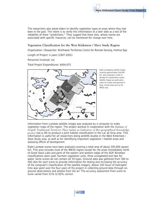
115∞<br />
45-17<br />
46-15<br />
46-14<br />
110∞<br />
46-13<br />
44-14<br />
44-15<br />
45-12<br />
105∞<br />
43-13<br />
0 100 km<br />
Prepared by the Centre for Remote Sensing<br />
Information from L<strong>and</strong>sat satellite images was analyzed by a computer to make<br />
vegetation maps of the region. The project worked in cooperation with the Habitat of<br />
Dogrib Traditional Territory: Place names as Indicators of Bio-geographical Knowledge<br />
project (see p.39) to produce a joint habitat classification in the Lac de Gras area. This<br />
information is useful for all researchers doing wildlife studies in the West Kitikmeot /<br />
Slave Study area, as well as for identifying important vegetation / habitat areas <strong>and</strong><br />
assessing effects of development.<br />
Eight L<strong>and</strong>sat scenes have been analyzed covering a total area of about 200,000 square<br />
km. This area includes most of the <strong>WKSS</strong> region except for the areas immediately north<br />
of Great Slave Lake <strong>and</strong> parts of the eastern <strong>and</strong> western edges of the SGP. Nineteen<br />
classifications were used: fourteen vegetation units, three unvegetated <strong>and</strong> two for<br />
water. Some scenes do not contain all 19 types. Ground data was gathered from 300 to<br />
500 sites for each scene to provide information for testing <strong>and</strong> increasing the accuracy<br />
of the computer’s classification of the satellite imagery. About 150 hours of helicopter<br />
time was spent over the four years of the project in collecting ground data through onground<br />
observations <strong>and</strong> photos from the air. The accuracy assessment from scene to<br />
scene varied from 51% to 82% correct.<br />
100∞<br />
68∞<br />
66∞<br />
64∞<br />
Eight overlapping satellite images,<br />
covering approximately 200,000<br />
km 2 were analyzed in order to<br />
develop the classification system.<br />
Satellite images are particularly<br />
useful for studies <strong>and</strong> planning in<br />
large, remote areas such as the<br />
<strong>WKSS</strong> area.