fishery management report no. 12–46 - Alaska Department of Fish ...
fishery management report no. 12–46 - Alaska Department of Fish ...
fishery management report no. 12–46 - Alaska Department of Fish ...

You also want an ePaper? Increase the reach of your titles
YUMPU automatically turns print PDFs into web optimized ePapers that Google loves.
NORTHERN PIKE<br />
Minto Flats<br />
Background and historic perspective<br />
The Minto Flats wetlands complex is located about 35 miles west <strong>of</strong> Fairbanks between the<br />
communities <strong>of</strong> Nenana and Minto (Figure 3). It is an approximately 500,000-acre area <strong>of</strong> marsh<br />
and lakes, interconnected by numerous sloughs and rivers. Most <strong>of</strong> the area is included in the<br />
Minto Flats State Game Refuge, which was established by the <strong>Alaska</strong> Legislature in 1988 to<br />
ensure protection and enhancement <strong>of</strong> habitat, conservation <strong>of</strong> fish and wildlife, and to guarantee<br />
continuation <strong>of</strong> public uses within the area. The Chatanika, Tolovana, and Tatalina rivers, and<br />
Washington, Goldstream, and numerous smaller creeks, flow into Minto Flats. These flowing<br />
waters come together as tributaries to the Tolovana River, itself a tributary to the Tanana River at<br />
its mouth at the southwestern end <strong>of</strong> the Flats. The waterways <strong>of</strong> the Flats are slow and<br />
meandering.<br />
The Minto Lakes, a group <strong>of</strong> large interconnected, generally shallow and heavily vegetated lakes<br />
in the eastern Flats, are a popular <strong>no</strong>rthern pike fishing and waterfowl hunting area. In addition<br />
to those who use boats, there are both guiding services and private pilots that travel to the lakes<br />
in floatplanes. Guides and private individuals have cabins on some <strong>of</strong> the sparse areas <strong>of</strong> higher<br />
ground <strong>no</strong>t regularly flooded. Minto Lakes are thought to support the majority <strong>of</strong> the <strong>no</strong>rthern<br />
pike sport <strong>fishery</strong> within the Tolovana River drainage, although the SWHS does <strong>no</strong>t separate the<br />
lakes’ harvest and catch data from the rest <strong>of</strong> Minto Flats.<br />
Minto Lakes are a major <strong>no</strong>rthern pike spawning and summer feeding area. In winter, much <strong>of</strong><br />
the flowing and standing water within the Flats becomes a<strong>no</strong>xic, forcing fish to move to waters<br />
<strong>of</strong> the Chatanika and Tolovana rivers or up tributary rivers to oxygenated areas. Winterkill is<br />
common and can be a confounding factor in attempts to predict fish population dynamics and<br />
assess angler impact. Northern pike are typically the only fish targeted by sport anglers in the<br />
Minto Flats area. These large piscivores are located throughout the Flats and can be readily<br />
taken on many types <strong>of</strong> lures.<br />
The <strong>no</strong>rthern pike <strong>fishery</strong> <strong>of</strong> the Lower Chatanika River is included in this section because<br />
<strong>no</strong>rthern pike move between Minto Lakes and Chatanika River, and the lower 35 miles <strong>of</strong> the<br />
Chatanika River is within Minto Flats. Similarly, because effort, catch, and harvest estimates for<br />
the Tolovana River appear occasionally in the SWHS data, and because Minto Flats and all <strong>of</strong> its<br />
waters are within the Tolovana River drainage, general references in this section to the Minto<br />
Flats complex and/or Tolovana River drainage should be considered a summation <strong>of</strong><br />
effort/harvest or catch <strong>of</strong> <strong>no</strong>rthern pike in the Tolovana River, Minto Flats, and the Lower<br />
Chatanika River drainage.<br />
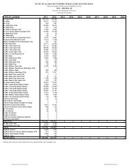
The Tolovana River drainage/Minto Flats complex <strong>no</strong>rthern pike population has supported a<br />
major proportion <strong>of</strong> the TRMA <strong>no</strong>rthern pike sport <strong>fishery</strong> for many years (Table 7). It was<br />
primarily a summer <strong>fishery</strong> until the mid-1980s, when an intensive sport <strong>fishery</strong> developed on<br />
concentrations <strong>of</strong> <strong>no</strong>rthern pike overwintering in the Chatanika River just upstream from the<br />
mouth <strong>of</strong> Goldstream Creek. A subsistence <strong>fishery</strong> for <strong>no</strong>rthern pike (and whitefish) occurs near<br />
the village <strong>of</strong> Minto and at historically used sites in the eastern portions <strong>of</strong> Minto Flats (Andrews<br />
1988). Gillnets are used throughout the open-water period and <strong>no</strong>rthern pike are taken through<br />
the ice with hook-and-line.<br />
19