

Geophysical Investigations - Oak Island Treasure
Geophysical Investigations - Oak Island Treasure
Geophysical Investigations - Oak Island Treasure

You also want an ePaper? Increase the reach of your titles
YUMPU automatically turns print PDFs into web optimized ePapers that Google loves.
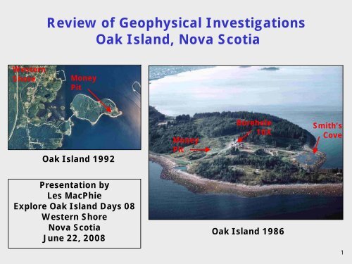
Western<br />
Shore<br />
Review of <strong>Geophysical</strong> <strong>Investigations</strong><br />
<strong>Oak</strong> <strong>Island</strong>, Nova Scotia<br />
Money<br />
Pit<br />
<strong>Oak</strong> <strong>Island</strong> 1992<br />
Presentation by<br />
Les MacPhie<br />
Explore <strong>Oak</strong> <strong>Island</strong> Days 08<br />
Western Shore<br />
Nova Scotia<br />
June 22, 2008<br />
Money<br />
Pit<br />
Borehole<br />
10X<br />
<strong>Oak</strong> <strong>Island</strong> 1986<br />
Smith’s<br />
Cove<br />
1
Outline of Presentation<br />
1. Introduction<br />
2. Geological Conditions<br />
3. <strong>Geophysical</strong> Survey by Peter Beamish 1965 and 1966<br />
4. Barringer <strong>Geophysical</strong> Survey 1988<br />
5. <strong>Oak</strong> <strong>Island</strong> Detection Program 1992 to 1994<br />
6. Ground Penetrating Radar Survey 2001<br />
7. Review of Theories to Define Future Targets for<br />
<strong>Geophysical</strong> Surveys<br />
8. Methods of Exploration and Prospects for Success in<br />
Future <strong>Geophysical</strong> Surveys<br />
9. Conclusions<br />
2
Location of <strong>Oak</strong> <strong>Island</strong>, Nova Scotia<br />
3
<strong>Oak</strong> <strong>Island</strong> Lot Distribution<br />
Present Ownership (2008)<br />
Lot 5 – Robert Young<br />
Lots 9 to 12 and 14 – Fred Nolan and Friends<br />
Lot 13 – John Johnston<br />
Lot 23 – Dan and David Blankenship<br />
Lot 25 – Alan Kostrzewa (Michigan Group)<br />
Remaining 23 Lots – Dan Blankenship and<br />
Michigan Group<br />
The <strong>Treasure</strong> Trove License is in<br />
the possession of <strong>Oak</strong> <strong>Island</strong><br />
Tours which is a Company<br />
formed by the Michigan Group.<br />
4
<strong>Geophysical</strong> <strong>Investigations</strong> and Reviews<br />
at <strong>Oak</strong> <strong>Island</strong><br />
Name Year Description Reference<br />
Peter Beamish 1965/66<br />
Magnetic survey and other<br />
geophysical methods<br />
Magnetic and Very Low Frequency<br />
Barringer 1988 Barringer 1988<br />
(VLF) surface surveys<br />
<strong>Oak</strong> <strong>Island</strong><br />
Detection<br />
Program<br />
1992/93 Review of geophysical methods<br />
1994<br />
1994<br />
Radarscan 2001<br />
Down hole and cross hole surveys<br />
in five deep holes at Money Pit<br />
Magnetic survey west of Money Pit<br />
Ground Penetrating Radar (GPR)<br />
survey north of Hole 10X<br />
Barber and<br />
Beamish 1965<br />
Triton 1994<br />
Radarscan<br />
2001<br />
Vincent Murphy 1989 Review of Barringer survey<br />
Murphy 1989<br />
5
Outline of Presentation<br />
1. Introduction<br />
2. Geological Conditions<br />
3. <strong>Geophysical</strong> Survey by Peter Beamish 1965 and 1966<br />
4. Barringer <strong>Geophysical</strong> Survey 1988<br />
5. <strong>Oak</strong> <strong>Island</strong> Detection Program 1992 to 1994<br />
6. Ground Penetrating Radar Survey 2001<br />
7. Review of Theories to Define Future Targets for<br />
<strong>Geophysical</strong> Surveys<br />
8. Methods of Exploration and Prospects for Success in<br />
Future <strong>Geophysical</strong> Surveys<br />
9. Conclusions<br />
6
Surface Geology and Drumlins<br />
Western Mahone Bay<br />
<strong>Oak</strong> <strong>Island</strong><br />
B A Y<br />
Drumlins<br />
Drumlins<br />
Ref: Stae and Fowler 1981<br />
7
Bedrock Geology Western Mahone Bay<br />
Boundary of<br />
Windsor Group and<br />
Maguma Group<br />
True<br />
North<br />
Ref: Giles 1981<br />
8
Geology of<br />
<strong>Oak</strong> <strong>Island</strong><br />
Meguma<br />
Slate Outcrops<br />
True<br />
North<br />
Meguma<br />
Slate<br />
Meguma<br />
Slate<br />
Anhydrite<br />
Bedrock<br />
160 Feet<br />
Glacial<br />
Till<br />
Money<br />
Pit<br />
200 Feet<br />
Anhydrite<br />
Bedrock<br />
9
Drilling <strong>Investigations</strong> at the Money Pit<br />
1. Becker Drilling 1967 (Archaeological)<br />
2. Warnock Hersey 1969 (Geotechnical/Archaeological)<br />
3. Golder Associates 1970 (Geotechnical/Archaeological)<br />
4. Detection Program Drilling 1993 (<strong>Geophysical</strong>)<br />
10
Plan of Geotechnical/Archaeological Holes<br />
Section B-B<br />
Photo<br />
Section A-A<br />
10X<br />
Golder WH<br />
Geotechnical Holes<br />
Archaeological Holes<br />
10X<br />
Fence Around<br />
Money Pit<br />
11
Geotechnical Section A-A at Money Pit and 10X<br />
Intrerglacial<br />
Clays and Silts<br />
Broken Anhydrite<br />
Money<br />
Pit<br />
Clayey<br />
Till<br />
Competent Anhydrite<br />
Note:<br />
Historical shafts, tunnels and<br />
drill holes are not shown<br />
10X<br />
SAND<br />
LAYER<br />
Silty<br />
Till<br />
IN SAND<br />
LAYER<br />
Broken Anhydrite Scenarios<br />
1. Fractured bedrock with cavities and soil infillings<br />
2. Huge anhydrite boulders in soil matrix<br />
12
Geotechnical Section B-B at Money Pit<br />
and Dunfield Excavation<br />
Photo<br />
Dunfield<br />
Excavation<br />
Intrerglacial<br />
Clays and Silts<br />
Clayey<br />
Till<br />
Silty<br />
Till<br />
Competent<br />
Anhydrite<br />
Note:<br />
Historical shafts, tunnels and<br />
drill holes are not shown<br />
Money<br />
Pit<br />
Broken<br />
Anhydrite<br />
Hedden<br />
Shaft<br />
Intact<br />
Chappell<br />
Shaft<br />
Collapsed<br />
Dunfield Excavation 1965/66<br />
13
Depth of Cavity/Soil Zones in Broken Anhydrite<br />
Hole<br />
No<br />
Distance and<br />
Direction<br />
from Money<br />
Pit (Feet)<br />
Depth of Cavity/Soil Zone Within Anhydrite (Feet)<br />
Cavity<br />
Thickness<br />
of Zone<br />
(Feet)<br />
195? – 204<br />
W1 50 NE<br />
20 - 181 - 186 186 – 195?<br />
24<br />
N=58<br />
W3<br />
61 NW<br />
Anhydrite<br />
Thickness<br />
Above Zone<br />
(Feet)<br />
Cavity or<br />
Loose Soil<br />
5 166 – 170 - 170 – 178<br />
8 -<br />
- 186 - 197 11<br />
51<br />
W5 19 S<br />
8 -<br />
- 180 - 206 26<br />
4<br />
W6 120 SSW No cavities or soil zones encountered in broken anhydrite<br />
W7 17 S 15 - - 180 - 209 29 9<br />
10X 176 NE 50 230 - 235 - - - 5 26<br />
G101 73 S 53 - - -<br />
G102 50 S 52 - - -<br />
G103 10 E 28 - -<br />
185 – 200<br />
Reworked<br />
G104 72 SSW 47 - - -<br />
G202 174 NE 43 - - 217 – 238 Ft 21<br />
5<br />
G204 267 NE 13 211 - 213 - 213 - 217<br />
Loose Soil Dense Soil<br />
217 – 227<br />
N>100<br />
214 – 219<br />
N=61, 58<br />
200 – 205<br />
N>100<br />
209 – 216<br />
N=41, 67<br />
217 – 236<br />
N=34-100<br />
Note: Twelve geotechnical and archaeological holes extended into the broken anhydrite. Eleven of the 12 holes encountered<br />
cavity/soil zones in the broken anhydrite.<br />
12<br />
10<br />
5<br />
20<br />
7<br />
Anhydrite<br />
Thickness<br />
Below Zone<br />
(Feet)<br />
46<br />
70<br />
Inc Soil Layer<br />
23<br />
22<br />
43<br />
36<br />
23 7<br />
14
Gradation of Overburden and Soil Infill in Anhydrite<br />
Silty Clay<br />
Overburden<br />
Interglacial<br />
Deposit<br />
Clay Layers<br />
in Broken<br />
Anhydrite<br />
Ref: Golder 1971<br />
Silty Till<br />
Overburden<br />
Silty Till Infill<br />
in Broken<br />
Anhydrite<br />
15
Outline of Presentation<br />
1. Introduction<br />
2. Geological Conditions<br />
3. <strong>Geophysical</strong> Survey by Peter Beamish 1965 and 1966<br />
4. Barringer <strong>Geophysical</strong> Survey 1988<br />
5. <strong>Oak</strong> <strong>Island</strong> Detection Program 1992 to 1994<br />
6. Ground Penetrating Radar Survey 2001<br />
7. Review of Theories to Define Future Targets for<br />
<strong>Geophysical</strong> Surveys<br />
8. Methods of Exploration and Prospects for Success in<br />
Future <strong>Geophysical</strong> Surveys<br />
9. Conclusions<br />
16
Peter Beamish <strong>Geophysical</strong> Survey 1965<br />
1. Peter Beamish, by arrangements through his colleague Donald Barrett (Mel<br />
Chappell's nephew), organized a two-week summer geophysical program on <strong>Oak</strong><br />
<strong>Island</strong> in 1965 for his students at Phillips Academy, Andover, Massachusetts<br />
with some students from Phillips Academy, Exeter, New Hampshire.<br />
2. <strong>Geophysical</strong> equipment borrowed from MIT, Cambridge, Massachusetts, included<br />
coin detector and electromagnetic (EM) unit for shallow depth exploration.<br />
Equipment from Bedford Institute of Oceanography (BIO), Bedford, Nova Scotia,<br />
included a two-coil EM unit for deeper penetration.<br />
3. The 1965 survey was done over a two-week period in August by 19 students and<br />
two instructors (Peter Beamish and Richard Barber) who camped on the island.<br />
Donald Barrett from BIO also attended and provided some geophysical survey<br />
equipment.<br />
4. A geophysical survey was done by Peter Beamish in 1966 and the results of this<br />
survey are not available.<br />
17
Phillips<br />
Academy<br />
Students<br />
Digging<br />
Southwest area<br />
of <strong>Oak</strong> <strong>Island</strong><br />
where anchor<br />
was found<br />
Photos courtesy Peter Beamish<br />
18
Beachcomber<br />
Coin Finder<br />
<strong>Geophysical</strong> Instruments Used by<br />
Peter Beamish in 1965 Survey<br />
EM Unit for<br />
Shallow Depth<br />
Portable<br />
Magnetometer<br />
Photos courtesy Peter Beamish<br />
One Coil of a Two<br />
Coil EM Unit<br />
19
Anchor Found by Peter Beamish 1965 and<br />
<strong>Geophysical</strong> Instruments for 1966 Survey<br />
Peter Beamish<br />
with Coin Finder<br />
EM Unit<br />
Photos courtesy Peter Beamish<br />
20
Beamish Anchor from 1965 and<br />
Anchor Fluke from Chappell Shaft 1931<br />
Peter Beamish<br />
with Anchor<br />
Photo courtesy Peter Beamish<br />
8 Inches<br />
Pick, Axe and<br />
Anchor Fluke<br />
from Chappell<br />
Shaft 1931<br />
14 Inches<br />
Anchor Fluke<br />
dimensions<br />
recorded by<br />
Mel Chappell<br />
21
Artifacts Found by Peter Beamish 1965 Survey<br />
Spanish 10 Merevedi similar<br />
to coin found by Student on<br />
beach at Smith's cove and<br />
identified by J J Teaparty Inc.,<br />
Boston as Merevedi 11, 1598<br />
Photo courtesy<br />
Peter Beamish<br />
22
Outline of Presentation<br />
1. Introduction<br />
2. Geological Conditions<br />
3. <strong>Geophysical</strong> Survey by Peter Beamish 1965 and 1966<br />
4. Barringer <strong>Geophysical</strong> Survey 1988<br />
5. <strong>Oak</strong> <strong>Island</strong> Detection Program 1992 to 1994<br />
6. Ground Penetrating Radar Survey 2001<br />
7. Review of Theories to Define Future Targets for<br />
<strong>Geophysical</strong> Surveys<br />
8. Methods of Exploration and Prospects for Success in<br />
Future <strong>Geophysical</strong> Surveys<br />
9. Conclusions<br />
23
OBJECTIVES<br />
Barringer <strong>Geophysical</strong> Survey 1988<br />
1. Detect possible salt water filled tunnels<br />
2. Detect concentrations of non-ferrous metals<br />
3. Detect concentrations of ferrous metals<br />
PROCEDURES<br />
1. Survey grid at 20 feet spacing at east end of <strong>Oak</strong> <strong>Island</strong><br />
2. Magnetic Survey for ferrous metals<br />
3. Very Low Frequency (VLF) Survey for salt water<br />
filled tunnels and possible detection of non-ferrous<br />
metals<br />
24
Barringer <strong>Geophysical</strong> Survey – People Present<br />
Chuck<br />
Brown<br />
David<br />
Tobias<br />
Alan<br />
Webb Bill<br />
Ulrich<br />
David<br />
Tobias<br />
Chuck<br />
Brown<br />
Dan<br />
Blankenship<br />
Dan<br />
Henskee<br />
Bill<br />
Ulrich<br />
Alan<br />
Webb<br />
Bill<br />
Cox<br />
Bill<br />
Sobey<br />
Dan<br />
Henskee<br />
Mark<br />
Webber<br />
Alan<br />
Webb<br />
25
Barringer <strong>Geophysical</strong> Survey – Setting out Grid<br />
Smith's Cove<br />
Money Pit and 10X Area<br />
Cave-in Pit<br />
Bill Cox and<br />
Dan Henskee<br />
26
Ground Surface Contours in 1988 from Barringer<br />
Elevation Survey Grid<br />
Approximate<br />
Contour of Ground<br />
Surface (Feet above<br />
mean sea level)<br />
Money<br />
Pit<br />
50<br />
Hole 10X<br />
Flood<br />
Tunnel?<br />
40<br />
30<br />
20<br />
10<br />
10<br />
True<br />
North<br />
Limits of 500 x 500 foot<br />
Survey Grid with Elevations<br />
at 20 foot spacing<br />
27
Mark<br />
Webber<br />
Barringer <strong>Geophysical</strong> Survey<br />
Magnetic and EM Measurements<br />
Money Pit Area<br />
Alan<br />
Webb<br />
Area North of Money Pit<br />
Equipment<br />
28
True<br />
North<br />
Limits of Barringer Magnetic Survey 1988<br />
Limits of<br />
Magnetic Survey<br />
Limits of<br />
Elevation<br />
Survey Grid<br />
29
Results of Barringer Magnetic Survey – Plate 2<br />
True<br />
North<br />
Typical<br />
Magnetic<br />
Anomalies<br />
Ref: Barringer 1994<br />
30
Magnetic Anomalies Superimposed on Map<br />
180' of 6"<br />
Steel Casing<br />
Not Defined<br />
Money<br />
Pit<br />
Hole 10X<br />
Various<br />
Buried Metal<br />
Flood<br />
Tunnel?<br />
120' of 5"<br />
Steel Casing<br />
Steel Plate<br />
True<br />
North<br />
Buried<br />
Metal<br />
31
Findings of Barringer Magnetic Survey<br />
1. Except for one location, the<br />
magnetic anomalies were<br />
associated with known<br />
occurrences of metal<br />
objects.<br />
2. At the one location in the<br />
southwest sector of the grid,<br />
the source of the magnetic<br />
anomaly was not known or<br />
defined.<br />
Note:<br />
Magnetic surveys define only<br />
ferrous metals (iron and steel)<br />
and are not able to detect nonferrous<br />
metals (silver and gold).<br />
Digging at magnetic anomaly<br />
beside South Shore Pit<br />
Steel plate found at depth of 1 to 4 feet<br />
beside South Shore Pit<br />
32
Limits of Barringer VLF <strong>Geophysical</strong> Survey 1988<br />
True<br />
North<br />
Fred Nolan Lots<br />
VLF<br />
Survey Line<br />
Limits of VLF<br />
Survey Grid<br />
33
Very Low Frequency (VLF) Transmitter Station<br />
Cutler, Maine<br />
34
Concept of VLF <strong>Geophysical</strong> Survey<br />
10 0<br />
VLF (15 to 30)<br />
35
VLF<br />
Electromagnetic Waves<br />
36
VLF<br />
Station<br />
Cutler<br />
Maine<br />
Annapolis<br />
Maryland<br />
Barringer VLF Survey Program<br />
Field Measured<br />
(See Notes)<br />
SVD of Total VLF<br />
Field<br />
Pre Pumping<br />
Results<br />
Post Pumping<br />
Results<br />
Plate 3 Plate 4<br />
FHD of VLF Tilt Plate 6 Plate 7<br />
SVD of Total VLF<br />
Field<br />
FHD of VLF Tilt<br />
Not<br />
Reported<br />
Not<br />
Reported<br />
Plate 5<br />
Plate 8<br />
Notes:<br />
1. "SVD of Total VLF Field" means Second Vertical Derivative of<br />
Total Very Low Frequency Field.<br />
2. "FHD of VLF Tilt" means First Horizontal Derivative of Very Low<br />
Frequency Tilt.<br />
37
True<br />
North<br />
Pre and Post Pumping – SVD of Total VLF<br />
Cutler, Maine Transmitter<br />
Plate 3<br />
Pre Pumping<br />
SVD of Total VLF<br />
Cutler, Maine<br />
True<br />
North<br />
Positive VLF<br />
Anomaly<br />
Ref: Barringer 1994<br />
Note: The limits of the<br />
anomalies are shown<br />
at 0.1 SVD Units<br />
Plate 4<br />
Post Pumping<br />
SVD of Total VLF<br />
Cutler, Maine<br />
38
True<br />
North<br />
Pre and Post Pumping – FHD of VLF Tilt<br />
Cutler, Maine Transmitter<br />
Plate 6<br />
Pre Pumping<br />
FHD of VLF Tilt<br />
Cutler, Maine<br />
True<br />
North<br />
Positive VLF<br />
Anomaly<br />
Ref: Barringer 1994<br />
Note: The limits of the<br />
anomalies are shown<br />
at 5.0 FHD Units<br />
Plate 7<br />
Post Pumping<br />
FHD of VLF Tilt<br />
Cutler, Maine<br />
39
True<br />
North<br />
SVD of Total VLF and FHD of VLF Tilt<br />
Post Pumping - Cutler, Maine Transmitter<br />
Plate 4<br />
Post Pumping<br />
SVD of Total VLF<br />
Cutler, Maine<br />
True<br />
North<br />
Positive VLF<br />
Anomaly<br />
Ref: Barringer 1994<br />
Plate 7<br />
Post Pumping<br />
FHD of VLF Tilt<br />
Cutler, Maine<br />
40
Interpretation Superimposed on VLF Anomalies<br />
from Plate 7 FHD of VLF Tilt – Post Pumping<br />
True<br />
North<br />
Money<br />
Pit<br />
Hole 10X<br />
Flood<br />
Tunnel?<br />
INTERPRETATION<br />
ANOMALOUS FEATURE<br />
ASSOCIATED WITH<br />
INTERPRETED TUNNELS<br />
Ref: Barringer 1994<br />
41
True<br />
North<br />
Interpretation and Anomalies<br />
Superimposed on Map<br />
Money<br />
Pit<br />
Ref: Barringer 1994<br />
Hole 10X<br />
Flood<br />
Tunnel?<br />
Halifax Tunnel?<br />
INTERPRETATION<br />
ANOMALOUS FEATURE<br />
ASSOCIATED WITH<br />
INTERPRETED TUNNELS<br />
42
Findings of Barringer VLF survey<br />
Main Conclusions of Barringer Report<br />
1. Some VLF anomalies (electromagnetic conductors) resulted from the<br />
presence of steel pipes and rails on surface and these were identified<br />
separately.<br />
2. Some of the other VLF anomalies (electromagnetic conductors) were<br />
interpreted as tunnels at a depth of 70 to 120 feet.<br />
3. Four features along these anomalies were interpreted to probably<br />
indicate a localized cavity or collapse in the tunnels but could be<br />
concentrations of non-ferrous metals.<br />
Evaluation by Triton and Independent Specialists<br />
1. The identification of tunnel locations by Barringer does not correspond to<br />
the historical understanding of old tunnel locations.<br />
2. The identification of tunnel locations by Barringer does not appear to be<br />
supported by significant VLF anomalies.<br />
3. The detection of non-ferrous metals using VLF surveys is not an effective<br />
approach and such features could be background effects.<br />
4. The results of the Barringer <strong>Geophysical</strong> Survey are disappointing.<br />
43
Outline of Presentation<br />
1. Introduction<br />
2. Geological Conditions<br />
3. <strong>Geophysical</strong> Survey by Peter Beamish 1965 and 1966<br />
4. Barringer <strong>Geophysical</strong> Survey 1988<br />
5. <strong>Oak</strong> <strong>Island</strong> Detection Program 1992 to 1994<br />
6. Ground Penetrating Radar Survey 2001<br />
7. Review of Theories to Define Future Targets for<br />
<strong>Geophysical</strong> Surveys<br />
8. Methods of Exploration and Prospects for Success in<br />
Future <strong>Geophysical</strong> Surveys<br />
9. Conclusions<br />
44
Objectives and Components of<br />
<strong>Oak</strong> <strong>Island</strong> Detection Program<br />
Progressive Objectives of Program<br />
1. Identify non ferrous metals in Money Pit area with down hole surveys.<br />
2. Identify chambers and tunnels below 80 feet depth in Money Pit area<br />
with cross hole surveys.<br />
3. Identify ferrous metals in the area west of the Money Pit with a magnetic<br />
survey (possibly locate iron chests containing treasure).<br />
Components of Program<br />
1. Five deep holes were drilled to about 250 feet depth around the Money Pit<br />
forming a ring of approximately 60 to 70 feet diameter. Existing Hole<br />
B24/W8 was to be used as a central hole within the ring.<br />
2. Down hole magnetic and electromagnetic (EM) surveys were done in each<br />
hole.<br />
3. Cross hole seismic surveys were done across the Money Pit area.<br />
4. A magnetic survey was done to the west of the Money Pit area.<br />
45
Plan of Five Deep <strong>Geophysical</strong> Holes<br />
and B24/W8 at Money Pit<br />
True<br />
North<br />
93-02<br />
93-04<br />
93-01<br />
B24/W8<br />
93-05<br />
93-03<br />
Lateral<br />
Drift<br />
46
Down Hole EM Survey Limits at 25 Ft Diameter<br />
True<br />
North<br />
93-02<br />
93-04<br />
93-01<br />
B24/W8<br />
93-05<br />
Money<br />
Pit<br />
Bottom<br />
of Hole<br />
93-03<br />
Top of<br />
Hole<br />
At 25 feet should<br />
detect non ferrous<br />
metal of 1 cu m<br />
47
Typical Magnetic and EM Profiles from Hole 93-03<br />
Magnetic Profile<br />
Depth<br />
0<br />
100 Ft<br />
30.5 m<br />
200 Ft<br />
61.0 m<br />
Ref: Triton 1994<br />
Interference from steel<br />
casing in the ground<br />
prevented definition of<br />
non ferrous metals in<br />
the EM profile<br />
EM Profile<br />
48
Plan of Cross Hole Seismic Tomography Panels<br />
B, C, D and G at Money Pit<br />
True<br />
North<br />
93-02<br />
93-04<br />
Panel D<br />
93-01<br />
Panel G<br />
B24/W8<br />
93-05<br />
Panel B<br />
Panel C<br />
93-03<br />
49
Photo Showing Location of Seismic Cross Hole<br />
Tomography Panels B, C, D and G at Money Pit<br />
93-05 Panel G<br />
Panel C<br />
93-04<br />
Panel D<br />
93-03<br />
93-02<br />
Panel B<br />
93-01<br />
50
Initial Straight Ray Results Panels B, D, G and C<br />
Generalized<br />
Stratigraphy<br />
at Money Pit<br />
160 Ft<br />
205 Ft<br />
Glacial<br />
Till<br />
Broken<br />
Anhydrite<br />
Competent<br />
Anhydrite<br />
Ref: Triton 1994<br />
Depth - Feet<br />
Money<br />
Pit<br />
70 Ft<br />
B D G<br />
C<br />
Velocity<br />
kFt/sec<br />
51
Plan of Cross Hole Seismic Tomography Panel D<br />
Used for Enhanced Interpretation<br />
True<br />
North<br />
93-02<br />
93-04<br />
Northwest<br />
93-01<br />
Panel D (70 Ft)<br />
Southeast<br />
B24/W8<br />
93-05<br />
93-03<br />
52
Photo Showing Location of Cross Hole<br />
Seismic Tomography Panel D at Money Pit<br />
93-05<br />
93-04<br />
Southeast<br />
Panel D<br />
Northwest<br />
93-03<br />
93-02<br />
93-01<br />
53
Enhanced Straight Ray and Curved Ray Results<br />
for Panel D Looking Southeast<br />
Generalized<br />
Stratigraphy<br />
at Money Pit<br />
160 Ft<br />
205 Ft<br />
Glacial<br />
Till<br />
Broken<br />
Anhydrite<br />
Competent<br />
Anhydrite<br />
Ref: Triton 1994<br />
Straight Ray<br />
Money<br />
Pit<br />
Curved Ray<br />
54
Profile of Curved Ray Tomography Results<br />
for Panel D Looking Northwest<br />
Money<br />
Pit<br />
Money<br />
Pit<br />
93-04<br />
Panel D<br />
93-03<br />
Tomography Data Ref: Triton 1994<br />
55
True<br />
North<br />
Magnetic Survey 1994<br />
Limit of Magnetic Survey 1994<br />
Limit of Barringer<br />
Magnetic Survey 1988<br />
56
Conclusions of <strong>Oak</strong> <strong>Island</strong> Detection Program<br />
1. During down hole surveys a great deal of interference occurred due to<br />
the presence of steel drill rods and casings in the area of the Money Pit.<br />
2. Hole B24/W8 could not be used for down hole magnetic and EM<br />
surveys because it had steel casing to a depth of about 200 feet.<br />
3. The down hole magnetic testing was not able to identify the inferred ½<br />
inch thick iron plate drilled through at a depth of 198 feet in Hole B25<br />
located about 30 feet from the detection holes.<br />
4. The down hole EM testing (after allowance for magnetic effects) did<br />
not identify reliable anomalous features which may represent non<br />
ferrous metals.<br />
5. The cross hole seismic tomography survey at the Money Pit defined the<br />
geological zones of soil and rock but would not have been able to<br />
define regular shapes of underground chambers or tunnels (if they<br />
were not collapsed) due to the complex and irregular subsurface<br />
conditions in the broken anhydrite zone.<br />
57
Outline of Presentation<br />
1. Introduction<br />
2. Geological Conditions<br />
3. <strong>Geophysical</strong> Survey by Peter Beamish 1965 and 1966<br />
4. Barringer <strong>Geophysical</strong> Survey 1988<br />
5. <strong>Oak</strong> <strong>Island</strong> Detection Program 1992 to 1994<br />
6. Ground Penetrating Radar Survey 2001<br />
7. Review of Theories to Define Future Targets for<br />
<strong>Geophysical</strong> Surveys<br />
8. Methods of Exploration and Prospects for Success in<br />
Future <strong>Geophysical</strong> Surveys<br />
9. Conclusions<br />
58
Location of Ron Aston Drilling Sites 1999<br />
Leading to GPR Survey in 2001<br />
Area A<br />
49 Probes<br />
25 to 45 Ft<br />
(One to 60 Ft)<br />
Area B<br />
33 Probes<br />
to 25 Ft<br />
Money<br />
Pit<br />
Contour of Ground<br />
Surface (Ft amsl)<br />
Limits of<br />
Elevation<br />
Survey Grid<br />
Hole 401<br />
50<br />
Hole 10X<br />
40<br />
30<br />
20<br />
Ron Aston<br />
Base Line<br />
N83°E and<br />
Assumed<br />
Flood Tunnel<br />
10<br />
10<br />
True<br />
North<br />
Ron Aston<br />
Assumed Offset<br />
Tunnel<br />
59
Location of Ron Aston Search Area<br />
and Drilling Site 2001<br />
Contour of Ground<br />
Surface (Ft amsl)<br />
Money<br />
Pit<br />
Limits of<br />
Elevation<br />
Survey Grid<br />
Hole<br />
401<br />
Hole 10X<br />
50<br />
40<br />
Ron Aston<br />
Base Line<br />
2001<br />
Search<br />
Area<br />
30<br />
20<br />
10<br />
40 Probes<br />
No Depth<br />
Data<br />
10<br />
True<br />
North<br />
60
Location of GPR Surveys 2001<br />
Contour of Ground<br />
Surface (Ft amsl)<br />
Money<br />
Pit Hole 10X<br />
Limits of<br />
Elevation<br />
Survey Grid<br />
Hole<br />
401<br />
50<br />
40<br />
30<br />
Ron Aston<br />
Base Line<br />
GPR Survey<br />
Area 1<br />
20<br />
10<br />
GPR Survey<br />
Area 2<br />
10<br />
True<br />
North<br />
61
Typical Results of 2001 GPR Survey of Area 1<br />
1. GPR Equipment used:<br />
Sensors & Software Inc.<br />
Pulse Ekko 100<br />
2. Survey done November 14<br />
to 18, 2001.<br />
3. More work recommended<br />
to define the nature of<br />
three anomalies found.<br />
Ref: Radarscan 2001<br />
Plan of Typical Results<br />
Depth 35 to 45 Feet<br />
Plan of Typical Results<br />
Depth 45 to 55 Feet<br />
62
Outline of Presentation<br />
1. Introduction<br />
2. Geological Conditions<br />
3. <strong>Geophysical</strong> Survey by Peter Beamish 1965 and 1966<br />
4. Barringer <strong>Geophysical</strong> Survey 1988<br />
5. <strong>Oak</strong> <strong>Island</strong> Detection Program 1992 to 1994<br />
6. Ground Penetrating Radar Survey 2001<br />
7. Review of Theories to Define Future Targets for<br />
<strong>Geophysical</strong> Surveys<br />
8. Methods of Exploration and Prospects for Success in<br />
Future <strong>Geophysical</strong> Surveys<br />
9. Conclusions<br />
63
Knights Templar<br />
64
Sir Francis Drake and Queen Elizabeth 1<br />
Did Drake Deceive the Queen?<br />
Queen Elizabeth I 1533 - 1603<br />
Sir Francis Drake 1540 - 1596<br />
65
Sir Francis Bacon and William Shakespeare<br />
The Missing Original Manuscripts and<br />
The Bacon-Shakespeare Authorship Controversy<br />
Sir Francis Bacon<br />
1561 - 1626<br />
William Shakespeare<br />
1564 - 1616<br />
Shakespeare's First Folio<br />
1623<br />
66
Spanish Galleon Lost at Sea<br />
67
Sir William Phips and Recovery of the<br />
<strong>Treasure</strong> from the Concepción 1688/89<br />
Ref: Bowden 1996 (National Geographic)<br />
68
Sir William Phips and Recovery of the<br />
<strong>Treasure</strong> from the Concepción 1688/89<br />
Sinking<br />
of the<br />
Concepción<br />
1641<br />
•500 people<br />
on board<br />
•300 people<br />
lost<br />
•200 people<br />
survived<br />
Ref: Bowden<br />
1996<br />
(National<br />
Geographic)<br />
69
<strong>Treasure</strong> from the Concepción (Leftovers)<br />
(Nuesta Señora de la pura y limpia Concepción)<br />
Articles recovered in 1978 by Burt Webber<br />
Ref: Bowden 1996 (National Geographic)<br />
70
Pirates<br />
1883 2006<br />
71
A Recent Theory - The Portuguese<br />
1. In the 1500s, during the Portuguese voyages of discovery,<br />
Portuguese cartographers mapped the east coast of America in<br />
considerable detail with highly accurate latitudes (Woodward<br />
2007).<br />
2. In the 1500s, the Barcelos family from the Azores was granted land<br />
in Portuguese controlled North America. They used islands and<br />
mainland areas of the New World to raise livestock for colonization<br />
and future voyages (Vigneras 1973).<br />
3. Based on documents dated 1568, the Barcelos family petitioned to<br />
the King's Purveyor to settle on an island in North America called<br />
"Barcellona de Sam Bardão" where the family was "breeding herds<br />
of cows, sheep, goats and swine" (Vigneras 1973). This is believed<br />
to be the island identified on Velho Chart 3v (1560) as "Ilha<br />
Barcelonas" and this island appears to be in Mahone Bay.<br />
4. The theory proposed is that the Barcelos family, and other wealthy<br />
families of the Azores, buried their gold, silver and jewels on an<br />
island in Mahone Bay before the Spanish take over in 1583.<br />
72
1560 Portuguese Chart of Madagascar<br />
and Modern Map to Illustrate Latitude Accuracy<br />
-10º<br />
(Latitude from<br />
scale on full<br />
size chart)<br />
Bartholomeu Velho Chart 7v 1560<br />
Portuguese (Berkeley www)<br />
Sainte<br />
Marie<br />
<strong>Island</strong><br />
Tropic of<br />
Capricorn<br />
(-23.5°)<br />
Modern Map<br />
-10º<br />
Sainte<br />
Marie<br />
<strong>Island</strong><br />
73
1560 Portuguese Chart of the New World<br />
and Modern Map to Illustrate Latitude 44.5°<br />
Bartolomeu Velho Chart 4 1560 Portuguese (Berkeley www)<br />
60º<br />
55º<br />
50º<br />
45º<br />
Actual <strong>Oak</strong> <strong>Island</strong> Latitude 44.5°<br />
Mahone Bay?<br />
Modern Map<br />
Cape Race Nfld<br />
60º<br />
Mahone Bay<br />
55º<br />
50º<br />
45º<br />
74
Comparison of Three Velho Charts at Lat. 44.5°<br />
Ilha<br />
Barcelonas<br />
Gulfo de Sam Bernaldo<br />
(Gulfo de Sam Bardão?)<br />
Gulfo de Sam<br />
Atonio<br />
<strong>Oak</strong> <strong>Island</strong>?<br />
Velho Chart 3v<br />
West Indies and<br />
Surrounding Coasts<br />
Actual <strong>Oak</strong> <strong>Island</strong> Latitude 44.5°<br />
<strong>Oak</strong> <strong>Island</strong>?<br />
Velho Chart 4<br />
North Atlantic and Nfld<br />
a Barcelona<br />
(a is the definite feminine<br />
article and could<br />
designate family or city)<br />
Bartolomeu Velho Charts 1560 Portuguese (Berkeley www)<br />
Gulfo de Sam<br />
Atonio<br />
<strong>Oak</strong> <strong>Island</strong>?<br />
Velho Chart 4v<br />
South America and Nfld<br />
75
Velho Chart 4v and Modern Map Showing<br />
Gulf at Latitude 44.5°<br />
a Barcelona<br />
44.5°<br />
<strong>Oak</strong> <strong>Island</strong>?<br />
Gulfo de Sam Atonio<br />
Velho Chart 4v<br />
South America and Nfld<br />
(Berkeley www)<br />
69<br />
Statute<br />
Miles<br />
(Based on<br />
1.0° Lat)<br />
<strong>Oak</strong> <strong>Island</strong><br />
44.5°<br />
10 Miles<br />
Mahone Bay<br />
LaHave <strong>Island</strong><br />
Modern Map<br />
St. Margarets Bay<br />
76
Portuguese Flag Symbol from 1500s<br />
Compared to Engraved Hedden Stone<br />
Escutcheon<br />
(or Quina)<br />
containing five<br />
Bezants (white dots)<br />
Portuguese Flag 1495 to 1577<br />
Four Portuguese Bezants<br />
and Central Cross?<br />
Engraved granite stone found by<br />
Hedden in 1936<br />
77
Evaluation of the Portuguese Theory<br />
The Portuguese Theory is evaluated against the essential elements of motive,<br />
opportunity, means and circumstance proposed by Kinkor (1993) for such<br />
theories:<br />
1. Motive:<br />
The Spanish claim to Portugal in 1580 during the Portuguese succession<br />
crisis was resisted by the Azores. In 1583, a Spanish invasion of the Azores<br />
was imminent. The citizens of the Azores had a strong motive to hide and<br />
protect their collective wealth from the Spanish.<br />
2. Opportunity:<br />
After the unsuccessful invasion of the Azores by the Spanish in 1580, the<br />
influential families of the Azores had ample time to devise a well thought out<br />
plan to protect their wealth before the Spanish invasion of 1583.<br />
3. Means:<br />
There were facilities and personnel on the Azores with the ability to construct<br />
fortresses and civil works such as sewers. The work force included Italian<br />
hydraulic engineers and African slaves. The influential families of the Azores<br />
had the ships and navigation skills to make the voyage as well as the means<br />
to construct the underground works at <strong>Oak</strong> <strong>Island</strong>.<br />
4. Circumstance:<br />
The selection of <strong>Oak</strong> <strong>Island</strong> is consistent with the premise that valuables<br />
would be hidden at a remote location (Gulfo de Sam Benaldo) know to the<br />
Portuguese but relatively unknown to others.<br />
78
Theories - Who Buried What and When?<br />
Who What When<br />
1. The Knights Templar<br />
2. Spanish<br />
3. Spanish<br />
The treasure of the Knights Templar<br />
(The Holy Grail)<br />
<strong>Treasure</strong> from damaged Spanish<br />
Galleon which sunk on way home<br />
<strong>Treasure</strong> stored on several occasions<br />
in underground vaults<br />
1300s to 1400s<br />
1500s<br />
1500s<br />
4. Portuguese <strong>Treasure</strong> from the Azores 1580s<br />
5. Sir Francis Drake Plundered Spanish treasure Late 1500s<br />
6. Sir Francis Bacon<br />
7. Masons Sacred treasure 1600s to mid 1700s<br />
8. French<br />
9. Sir William Phips<br />
10. Conspirators from<br />
the British Military<br />
The original Shakespearean<br />
Manuscripts<br />
<strong>Treasure</strong> from French pay ship<br />
destined for Fortress Louisbourg<br />
<strong>Treasure</strong> recovered from the Spanish<br />
Galleon Concepción sunk in 1641<br />
1600s<br />
Mid 1700s<br />
Money Pit 1688-89<br />
Flood Tunnel 1752-54<br />
Spoils from the sack of Havana in 1762 Shortly after 1762<br />
11. Not Yet Identified Not Yet Identified Not Yet Identified<br />
Note: Other less credible theories include Early Civilizations, Egyptians, Incas, Mayans, Aztecs,<br />
Mi’kmaq, Vikings, Acadians, Pirates and Aliens.<br />
79
Theories – Where is the <strong>Treasure</strong>?<br />
Who Where<br />
1. Many Researchers Money Pit<br />
2. Laverne Johnson Offset chamber northwest of Money Pit<br />
3. Ron Aston Offset chamber north of Flood Tunnel<br />
4. Several Researchers Offset chamber from Money Pit<br />
5. Fred Nolan (and others) Fred Nolan's lots, swamp<br />
6. Petter Amundsen Locations referenced to Boulder Cross<br />
7. Several Researchers<br />
9. Michael Bradley<br />
Various locations on <strong>Oak</strong> <strong>Island</strong> by separate<br />
groups at different times<br />
8. Several Researchers Other <strong>Island</strong>s in Mahone Bay<br />
New Ross, Nova Scotia, 20 miles inland<br />
from <strong>Oak</strong> <strong>Island</strong><br />
10. Not Yet Identified Money Pit and/or elsewhere<br />
80
Theories – What Type of Underground Works<br />
were Constructed?<br />
1. Historical mining activities typically involve rectangular shafts. It<br />
is exceptional that the initial excavation of the Money Pit was<br />
circular in shape.<br />
2. Much research has been done to find historical construction<br />
similar to the filter bed and flood system at <strong>Oak</strong> <strong>Island</strong>. Although<br />
no similar system has been found, three sites have been identified<br />
as having some resemblance to the <strong>Oak</strong> <strong>Island</strong> works.<br />
3. All of the three sites are associated with Pirate "Banks" and are:<br />
Kavanach Hill, Haiti<br />
Port Royal, Jamaica<br />
Sainte Marie <strong>Island</strong>, Madagascar<br />
81
Ancient Chinese Gold Mine<br />
Tong Lu Shan, Hubei Province, China<br />
Prior to Sixth<br />
Century BC<br />
Mortice<br />
and<br />
Tennon<br />
Jointing<br />
Shafts and Adits<br />
Fifth Century BC to<br />
Third Century AD<br />
Ref: Argall 1981<br />
Hoisting ore<br />
in stages<br />
Hoisting water<br />
to drain mine<br />
82
Roman Gold Mine in Romania<br />
Second to Third Century AD<br />
Rosia Montana<br />
83
16 th Century European Mining<br />
Shafts<br />
and<br />
Adits<br />
Ref: Agricola 1556<br />
Mortice<br />
and<br />
Tennon<br />
Jointing<br />
84
Pirate Tunnels, Sainte Marie <strong>Island</strong>,<br />
Madagascar (1650 to 1725)<br />
Typical Geophex EM unit used<br />
to define Pirate Tunnels<br />
Ref: Clifford 2003<br />
85
Pirate Cemetery North of Pirate <strong>Island</strong><br />
Photos courtesy<br />
Tim Clinton<br />
86
Sainte Marie <strong>Island</strong>, Madagascar<br />
Photos courtesy Slav Domurat<br />
87
Lemur<br />
Madagascar<br />
Les<br />
88
Outline of Presentation<br />
1. Introduction<br />
2. Geological Conditions<br />
3. <strong>Geophysical</strong> Survey by Peter Beamish 1965 and 1966<br />
4. Barringer <strong>Geophysical</strong> Survey 1988<br />
5. <strong>Oak</strong> <strong>Island</strong> Detection Program 1992 to 1994<br />
6. Ground Penetrating Radar Survey 2001<br />
7. Review of Theories to Define Future Targets for<br />
<strong>Geophysical</strong> Surveys<br />
8. Methods of Exploration and Prospects for Success in<br />
Future <strong>Geophysical</strong> Surveys<br />
9. Conclusions<br />
89
Methods of Exploration and Prospects for Success<br />
Methods of Exploration<br />
1. One application of geophysical methods would be to explore the reasonably<br />
undisturbed areas surrounding the Money Pit with the objective of finding<br />
an offset chamber. There is only limited potential for successful use of<br />
geophysical exploration in other areas of <strong>Oak</strong> <strong>Island</strong>.<br />
2. The geophysical technology of Ground Penetrating Radar (GPR) should<br />
identify significant underground openings (or partially collapsed openings)<br />
to a depth of about 30 feet in a homogenous and undisturbed soil profile.<br />
3. The geophysical technology of Electromagnetic (EM) survey should be able<br />
to verify the presence of shallow underground openings and may be able to<br />
locate non ferrous metals at shallow depth in a homogenous and<br />
undisturbed soil profile. Shallow depth is some 30 to 50 feet.<br />
Prospects for Success<br />
1. The prospects for success of GPR used in the context described above are<br />
about 50/50 or less.<br />
2. The prospects for success of EM surveys used in the context described<br />
above are about 50/50 or less.<br />
3. The prospects for success are based on the assumption that a feature exists<br />
at shallow depth and thus there is less than a 50/50 chance of finding that<br />
feature using geophysical methods.<br />
90
Outline of Presentation<br />
1. Introduction<br />
2. Geological Conditions<br />
3. <strong>Geophysical</strong> Survey by Peter Beamish 1965 and 1966<br />
4. Barringer <strong>Geophysical</strong> Survey 1988<br />
5. <strong>Oak</strong> <strong>Island</strong> Detection Program 1992 to 1994<br />
6. Ground Penetrating Radar Survey 2001<br />
7. Review of Theories to Define Future Targets for<br />
<strong>Geophysical</strong> Surveys<br />
8. Methods of Exploration and Prospects for Success in<br />
Future <strong>Geophysical</strong> Surveys<br />
9. Conclusions<br />
91
Conclusions<br />
1. There are no new "silver bullet" geophysical technologies available<br />
today which are significantly superior to the technology used during<br />
the Barringer Survey of 1988 and the <strong>Oak</strong> <strong>Island</strong> Detection Program<br />
from 1992 to 1994.<br />
2. Definition of non ferrous metals in the Money Pit area by geophysical<br />
methods cannot be expected to be successful mainly due to the<br />
presence of steel rods and casings remaining in the ground from<br />
numerous past drilling programs.<br />
3. Definition of chambers and tunnels (even if they are not collapsed) in<br />
the broken anhydrite zone from 160 to 205 feet in the Money Pit area<br />
by geophysical methods cannot be expected to be successful due to the<br />
complex and irregular subsurface conditions which are know to exist.<br />
4. Beyond the Money Pit area, geophysical investigation would be useful<br />
to identify anomalies for investigation by drilling or shafting.<br />
Preferably such anomalies should be verified by at least two different<br />
geophysical methods.<br />
92
Acknowledgements<br />
• Jo Atherton<br />
• Peter Beamish<br />
• Dan Blankenship<br />
• Tim Clinton<br />
• Slav Domurat<br />
• Graham Harris<br />
• Ken Kinkor (Pirate History)<br />
• Vincent Murphy (Geophysics)<br />
• D'Arcy O'Connor<br />
• Dick Pflederer (Cartography)<br />
• David Tobias<br />
• Paul Wroclawski (Portuguese Theory)<br />
93
References 1 of 2<br />
1. Agricola, Georgius 1556. De Re Metallica. Translated by Hebert Clark Hoover and Lou<br />
Henry Hoover from the first Latin Edition of 1556, Dover Publications Inc., New York 1950<br />
(Reprint of the translation published by the Mining Magazine, London 1912).<br />
2. Argall, George O., Jr. 1981. Tong Lu Shan – A Jewel among Ancient Mines. World Mining,<br />
August 1981, pp 59-61.<br />
3. Barber, Richard and Beamish, Peter 1965. The Ghost that Guards $30 000 000.<br />
4. Barringer Geoservices, Inc. 1988. Magnetic-Gradiometer/VLF/Resistivity Survey, <strong>Oak</strong><br />
<strong>Island</strong>, Mahone Bay, Nova Scotia. Report to Triton Alliance Ltd., November 1988.<br />
5. Berkeley www: sunsite3.berkeley.edu/hehwebb/toc (Charts from Atlas attributed to<br />
Bartolomeu Veho c. 1560 now held at the Huntington Library - ms HM44).<br />
6. Bowden, Tracy 1996. <strong>Treasure</strong> From the Silver Bank, National Geographic, July 1996.<br />
7. Clifford, Barry with Paul Perry 2003. Return to <strong>Treasure</strong> <strong>Island</strong> and the Search for<br />
Captain Kidd, First Edition. William Morrow, An Imprint of Harper Collins Publishers,<br />
2003.<br />
8. Giles, P. S. 1981. The Windsor Group of the Mahone Bay Area, Nova Scotia. Nova Scotia<br />
Department of Mines and Energy, Paper 81-3, 1981.<br />
94
References 2 of 2<br />
9. Golder Associates 1971. Subsurface Investigation, The <strong>Oak</strong> <strong>Island</strong> Exploration, <strong>Oak</strong><br />
<strong>Island</strong>, Nova Scotia. Draft Report No. 69126 to Triton Alliance Ltd., Montreal, Quebec,<br />
April 28, 1971.<br />
10. Kinkor, Ken 1993. The <strong>Oak</strong> <strong>Island</strong> Mystery, Parts 1 and 2. Maine Boats and Harbours,<br />
August and October 1993.<br />
11. Murphy, Vincent 1989. Review (preliminary submission) Magnetic-Gradiometer/VLF/<br />
Resistivity Survey, <strong>Oak</strong> <strong>Island</strong>, Nova Scotia. Memorandum to Triton Alliance Ltd., May 3,<br />
1989.<br />
12. Radarscan Inc. 2001. GPR Survey, <strong>Oak</strong> <strong>Island</strong>, Nova Scotia. Report by Radarscan Inc.,<br />
Calgary, Alberta, December 2001.<br />
13. Stea, R. R. and Fowler, J. H. 1981. Pleistocene Geology and Till Geochemistry of Central<br />
Nova Scotia. Nova Scotia Department of Mines and Energy, Map 81-1, 1981.<br />
14. Triton 1994. <strong>Oak</strong> <strong>Island</strong> Detection Program. Various reports and correspondence on<br />
geophysical and related studies from 1992 to 1994.<br />
15. Vigneras, L.-A. 1973. The voyages of Diego and Manoel De Barcelos to Canada in the<br />
Sixteenth Century. Terrae Incognitae: The Annals of the Society for the History of<br />
Discoveries, Volume V, 1973, pp 61-64.<br />
16. Woodward, David (Ed.) 2007. The History of Cartography, Volume Three, Cartography<br />
in the European Renaissance (Chapter 38 Portuguese Cartography in the Renaissance<br />
pp 975 - 1068). The University of Chicago Press, 2007, 2180 pp.<br />
95
Don't Give Up the Search<br />
96
When <strong>Treasure</strong> is Recovered<br />
97
Western<br />
Shore<br />
Review of <strong>Geophysical</strong> <strong>Investigations</strong><br />
<strong>Oak</strong> <strong>Island</strong>, Nova Scotia<br />
Money<br />
Pit<br />
<strong>Oak</strong> <strong>Island</strong> 1992<br />
Presentation by<br />
Les MacPhie<br />
Explore <strong>Oak</strong> <strong>Island</strong> Days 08<br />
Western Shore<br />
Nova Scotia<br />
June 22, 2008<br />
Money<br />
Pit<br />
Borehole<br />
10X<br />
<strong>Oak</strong> <strong>Island</strong> 1986<br />
Smith’s<br />
Cove<br />
98