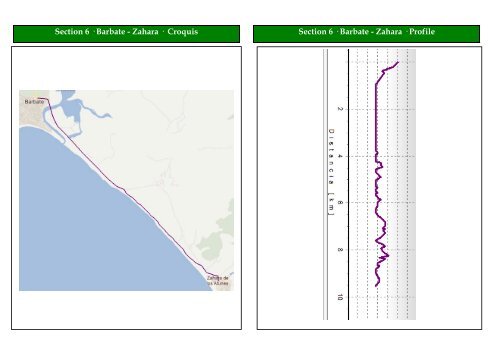
Section 6 · Barbate - Zahara · Croquis Section 6 · Barbate - Zahara · Profile
<strong>TransAndalus</strong> RoadBook · Province of Cádiz Section 6· Barbate - Zahara de los Atunes Total Partial Diagram Description Salimos de Barbate desde la rotonda del tramo anterior por la 0,00 0,00 Avenida Juan XXIII y luego, siguiendo recto, calle Zahara 0,35 2,15 3,50 5,20 5,70 0,35 1,80 1,45 1,70 0,50 Continuamos por la carretera de Zahara, en dirección al puente sobre la marisma de Barbate. Precaución con el tráfico. After passing extensive tidelands, you will see some small houses to the left. At this point, on your right, you can leave the highway to follow a sandy, but safer, path that runs parallel to the road, traveling SE. Follow the bordering path until the houses end, where there is a sign indicating "zona militar" and a ditch. Pass it, and take a track closer to the beach traveling SE parallel to the shore. Continue along the sandy track, going straight ahead at the crossroad, SE, parallel to the shore. Continue along the coast. After crossing an arroyo that seems to be dry, continue straight ahead through the crossroad, SE, parallel to the beach. 7,70 8,33 8,65 9,36 9,55 2,00 0,63 0,32 0,71 0,19 After a few dry arroyos, the track divides. Ignore the branch to the left and continue straight, parallel to the coast, SSE. At this point, the beach begins to widen. Ignore the crossroads and continue straight ahead, SE, a little farther from the coast. Leaving behind a concrete bridge, we arrive at an unpaved parking area by the side of the highway. Turn right onto the highway and continue SE along the bank of the river toward Zahara. Arriving by highway at the roundabout at the entrance to the town, take the first exit to the right, going S over the bridge into Zahara. Zahara de los Atunes. After entering the town via the bridge, take the second street to the left with various hotels and restaurants.
- Page 1 and 2: TransAndalus Andalucía by MTB 2,00
- Page 3 and 4: TransAndalus RoadBook · Provincia
- Page 5 and 6: Section 1 · Sanlúcar - Pto. Sta.
- Page 7 and 8: 5,88 6,15 6,50 8,40 8,85 9,15 0.63
- Page 9 and 10: 22,20 0.47 22,80 0.60 23,70 0.90 24
- Page 11 and 12: TransAndalus RoadBook · province o
- Page 13 and 14: TransAndalus RoadBook · Province o
- Page 15 and 16: TransAndalus RoadBook · Provincia
- Page 17 and 18: Section 3 · Puerto Real - Chiclana
- Page 19 and 20: 8,65 9,75 1,20 1,10 10,75 1,00 11,9
- Page 21 and 22: � DESCRIPTION In this section we
- Page 23 and 24: TransAndalus RoadBook · Province o
- Page 25 and 26: 19,35 0,45 19,50 0,15 20,15 0,65 20
- Page 27 and 28: Section 5 · Conil - Barbate · Ove
- Page 29 and 30: 14,65 0,65 15,55 0,90 16,05 0,55 16
- Page 31: TransAndalus RoadBook · Province o
- Page 35 and 36: change direction, leaving the coast
- Page 37 and 38: TransAndalus RoadBook · Province o
- Page 39 and 40: 21,80 2,20 22,00 0,20 22,10 0,10 22
- Page 41 and 42: TransAndalus RoadBook · Province o
- Page 43 and 44: Section 8 · Tarifa - El Bujeo · C
- Page 45 and 46: 11,35 0,75 11,60 0,25 12,00 0,40 17
- Page 47 and 48: Green Door, and then up a long incl
- Page 49 and 50: TransAndalus RoadBook · Province o
- Page 51 and 52: TransAndalus RoadBook · Province o
- Page 53 and 54: Section 10 · Algeciras - Castillo
- Page 55 and 56: 27.45 2.55 28.45 1.00 Continue stra
- Page 57 and 58: Section 11 · Castillo de Castellar
- Page 59 and 60: Total Partial Diagram Description R
- Page 61 and 62: might cross paths with wild boars,
- Page 63: TransAndalus RoadBook · Province o