

Topography and Sedimentation Characteristics of the Squaw Creek ...
Topography and Sedimentation Characteristics of the Squaw Creek ...
Topography and Sedimentation Characteristics of the Squaw Creek ...

You also want an ePaper? Increase the reach of your titles
YUMPU automatically turns print PDFs into web optimized ePapers that Google loves.
46 <strong>Topography</strong> <strong>and</strong> <strong>Sedimentation</strong> <strong>Characteristics</strong> <strong>of</strong> <strong>the</strong> <strong>Squaw</strong> <strong>Creek</strong> National Wildlife Refuge, Holt County, Missouri, 1937–2002<br />
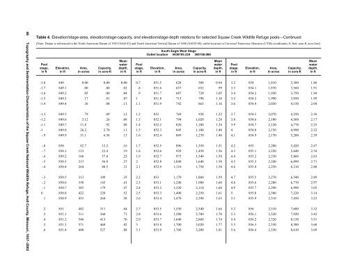
Table 4. Elevation/stage-area, elevation/stage-capacity, <strong>and</strong> elevation/stage-depth relations for selected <strong>Squaw</strong> <strong>Creek</strong> Wildlife Refuge pools—Continued<br />
[Note: Datum is referenced to <strong>the</strong> North American Datum <strong>of</strong> 1983 (NAD 83) <strong>and</strong> North American Vertical Datum <strong>of</strong> 1988 (NAVD 88); outlet location in Universal Transverse Mercator (UTM) coordinates; ft, feet; acre-ft, acre-foot]<br />
Pool<br />
stage,<br />
in ft<br />
Elevation,<br />
in ft<br />
Area,<br />
in acres<br />
Capacity,<br />
in acre-ft<br />
Mean<br />
water<br />
depth,<br />
in ft<br />
Pool<br />
stage,<br />
in ft<br />
South Eagle West Stage<br />
Outlet location 4436195.324 308158.066<br />
Elevation,<br />
in ft<br />
Area,<br />
in acres<br />
Capacity,<br />
in acre-ft<br />
Mean<br />
water<br />
depth,<br />
in ft<br />
Pool<br />
stage,<br />
in ft<br />
Elevation,<br />
in ft<br />
Area,<br />
in acres<br />
Capacity,<br />
in acre-ft<br />
-1.8 849 0.00 0.00 0.00 0.7 851.5 628 588 0.94 3.2 854 1,810 3,380 1.86<br />
-1.7 849.1 .00 .00 .02 .8 851.6 657 652 .99 3.3 854.1 1,870 3,560 1.91<br />
-1.6 849.2 .05 .00 .04 .9 851.7 687 720 1.05 3.4 854.2 1,930 3,750 1.94<br />
-1.5 849.3 .17 .01 .07 1 851.8 715 790 1.10 3.5 854.3 1,990 3,950 1.99<br />
-1.4 849.4 .36 .04 .11 1.1 851.9 742 863 1.16 3.6 854.4 2,030 4,150 2.04<br />
-1.3 849.5 .79 .09 .12 1.2 852 769 938 1.22 3.7 854.5 2,070 4,350 2.10<br />
-1.2 849.6 3.12 .26 .08 1.3 852.1 794 1,020 1.28 3.8 854.6 2,100 4,560 2.17<br />
-1.1 849.7 11.8 .92 .08 1.4 852.2 820 1,100 1.34 3.9 854.7 2,120 4,770 2.25<br />
-1 849.8 26.2 2.78 .11 1.5 852.3 845 1,180 1.40 4 854.8 2,150 4,990 2.32<br />
-.9 849.9 51.1 6.56 .13 1.6 852.4 869 1,270 1.46 4.1 854.9 2,170 5,200 2.39<br />
-.8 850 82.7 13.2 .16 1.7 852.5 896 1,350 1.51 4.2 855 2,200 5,420 2.47<br />
-.7 850.1 123 23.4 .19 1.8 852.6 929 1,450 1.56 4.3 855.1 2,220 5,640 2.54<br />
-.6 850.2 166 37.8 .23 1.9 852.7 975 1,540 1.58 4.4 855.2 2,230 5,860 2.63<br />
-.5 850.3 213 56.8 .27 2 852.8 1,040 1,640 1.58 4.5 855.3 2,240 6,090 2.71<br />
-.4 850.4 264 80.5 .31 2.1 852.9 1,110 1,750 1.58 4.6 855.4 2,250 6,310 2.80<br />
-.3 850.5 313 109 .35 2.2 853 1,170 1,860 1.59 4.7 855.5 2,270 6,540 2.89<br />
-.2 850.6 350 143 .41 2.3 853.1 1,240 1,980 1.60 4.8 855.6 2,280 6,770 2.97<br />
-.1 850.7 385 179 .47 2.4 853.2 1,320 2,110 1.60 4.9 855.7 2,290 6,990 3.05<br />
0 850.8 422 220 .52 2.5 853.3 1,400 2,250 1.61 5 855.8 2,300 7,220 3.14<br />
.1 850.9 455 264 .58 2.6 853.4 1,470 2,390 1.63 5.1 855.9 2,310 7,450 3.23<br />
.2 851 482 311 .64 2.7 853.5 1,530 2,540 1.66 5.2 856 2,310 7,680 3.32<br />
.3 851.1 511 360 .71 2.8 853.6 1,580 2,700 1.70 5.3 856.1 2,320 7,920 3.42<br />
.4 851.2 540 413 .76 2.9 853.7 1,640 2,860 1.74 5.4 856.2 2,320 8,150 3.51<br />
.5 851.3 571 468 .82 3 853.8 1,700 3,020 1.77 5.5 856.3 2,330 8,380 3.60<br />
.6 851.4 600 527 .88 3.1 853.9 1,760 3,200 1.81 5.6 856.4 2,330 8,610 3.69<br />
Mean<br />
water<br />
depth,<br />
in ft