Malaga in Spaine, his miraculous discovery and deliuery thence: And <strong>of</strong> his last and late returne from the Northerne Iles. … By William Lithgow. London, Nicholas Okes, 1632. 6. George Sandys, 1578–1644, Sandys Travailes: containing a history <strong>of</strong> the originall and present state <strong>of</strong> the Turkish empire: their lawes, governement, policy, military force, courts <strong>of</strong> justice, and commerce: the Mahometan religion and ceremonies. A description <strong>of</strong> Constantinople, the Grand Signiors Seraglio, and his manner <strong>of</strong> living: also, <strong>of</strong> Greece, with the religion and customes <strong>of</strong> the Græcians. Of Ægypt; the antiquity, hieroglyphicks, rites, customes, discipline, and religion <strong>of</strong> the Ægyptians: a voyage on the river Nilus: <strong>of</strong> Armenia, Grand Cairo, Rhodes, the Pyramides, Colossus; the former flourishing and present state <strong>of</strong> Alexandria. A description <strong>of</strong> the holy-land; <strong>of</strong> the Jews and severall sects <strong>of</strong> Christians living there; <strong>of</strong> Jerusalem, sepulchre <strong>of</strong> Christ, temple <strong>of</strong> Solomon; and what else either <strong>of</strong> antiquity, or worth observation. Lastly, Italy described, and the islands adjoyning; as Cyprus, Crete, Malta, Sicilia, the Æolian islands; <strong>of</strong> Rome, Venice, Naples, Syracusa, Mesena, Ætna, Scylla and Charybdis; and other places <strong>of</strong> note. Illustrated with fifty graven maps and figures. Fifth edition. London, Richard Cotes, 1652. 7. Petrus Bertius, 1565–1629, Natolie (map). Scale not given, colour, 81 x 121 mm, 1616. Likely to be from an edition <strong>of</strong> his small atlas, Tabularum Geographicarum Contractarm … libri tre (1600). Bertius was cosmographer to the French king Louis XIII from 1618. He was the brother-inlaw <strong>of</strong> both Jodocus Hondudius and Pieter van den Keere, with whom he collaborated. 8. Gerhard Mercator, 1512–1594, Natolie (map). Scale (ca. 1:1,000,000), colour, 14 x 18 cm, 1614. Gerhard Mercator was the most famous cartographer after Ptolemy. He was born in Rupelmonde, Flanders and died in Duisburg, Germany. He invented the Mercator projection and coined the name ‘atlas’ for a collection <strong>of</strong> maps. He had a great sense <strong>of</strong> exact scientific work and drew new maps in original conception, rather than copying the work <strong>of</strong> others. 9. Gerhard Mercator, 1512–1594, Natolia, quae olim Asia minor (map). Scale (ca. 1:794,000), colour, 14 x 18 cm, 1651. 10. Abraham Ortelius, 1527–1598, Natolie (map). Scale not given, colour, 14 x 18 cm, 1598? Abraham Ortelius was, after Mercator, the most famous cartographer <strong>of</strong> the 16th century. He was born and died in Amsterdam in the Netherlands. In 1570 he wrote and published the first uniform atlas, Theatrum Orbis Terrarum. 6 <strong>PEREGR<strong>IN</strong>ATIONS</strong> <strong>IN</strong> <strong>ASIA</strong> M<strong>IN</strong>OR
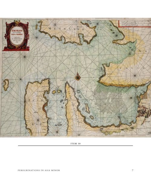
I T E M 3 0 <strong>PEREGR<strong>IN</strong>ATIONS</strong> <strong>IN</strong> <strong>ASIA</strong> M<strong>IN</strong>OR 7