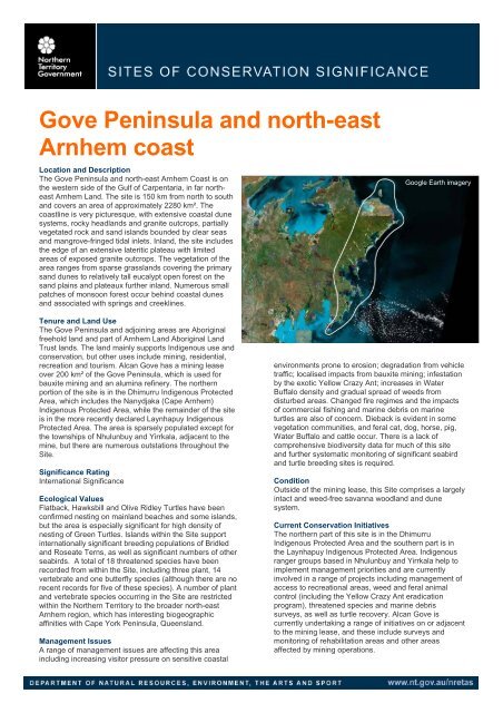
Gove Peninsula and north-east Arnhem coast - Natural Resources ...
Gove Peninsula and north-east Arnhem coast - Natural Resources ...
Gove Peninsula and north-east Arnhem coast - Natural Resources ...

You also want an ePaper? Increase the reach of your titles
YUMPU automatically turns print PDFs into web optimized ePapers that Google loves.
<strong>Gove</strong> <strong>Peninsula</strong> <strong>and</strong> <strong>north</strong>-<strong>east</strong><br />
<strong>Arnhem</strong> <strong>coast</strong><br />
Location <strong>and</strong> Description<br />
The <strong>Gove</strong> <strong>Peninsula</strong> <strong>and</strong> <strong>north</strong>-<strong>east</strong> <strong>Arnhem</strong> Coast is on<br />
the western side of the Gulf of Carpentaria, in far <strong>north</strong><strong>east</strong><br />
<strong>Arnhem</strong> L<strong>and</strong>. The site is 150 km from <strong>north</strong> to south<br />
<strong>and</strong> covers an area of approximately 2280 km². The<br />
<strong>coast</strong>line is very picturesque, with extensive <strong>coast</strong>al dune<br />
systems, rocky headl<strong>and</strong>s <strong>and</strong> granite outcrops, partially<br />
vegetated rock <strong>and</strong> s<strong>and</strong> isl<strong>and</strong>s bounded by clear seas<br />
<strong>and</strong> mangrove-fringed tidal inlets. Inl<strong>and</strong>, the site includes<br />
the edge of an extensive lateritic plateau with limited<br />
areas of exposed granite outcrops. The vegetation of the<br />
area ranges from sparse grassl<strong>and</strong>s covering the primary<br />
s<strong>and</strong> dunes to relatively tall eucalypt open forest on the<br />
s<strong>and</strong> plains <strong>and</strong> plateaux further inl<strong>and</strong>. Numerous small<br />
patches of monsoon forest occur behind <strong>coast</strong>al dunes<br />
<strong>and</strong> associated with springs <strong>and</strong> creeklines.<br />
Tenure <strong>and</strong> L<strong>and</strong> Use<br />
The <strong>Gove</strong> <strong>Peninsula</strong> <strong>and</strong> adjoining areas are Aboriginal<br />
freehold l<strong>and</strong> <strong>and</strong> part of <strong>Arnhem</strong> L<strong>and</strong> Aboriginal L<strong>and</strong><br />
Trust l<strong>and</strong>s. The l<strong>and</strong> mainly supports Indigenous use <strong>and</strong><br />
conservation, but other uses include mining, residential,<br />
recreation <strong>and</strong> tourism. Alcan <strong>Gove</strong> has a mining lease<br />
over 200 km² of the <strong>Gove</strong> <strong>Peninsula</strong>, which is used for<br />
bauxite mining <strong>and</strong> an alumina refinery. The <strong>north</strong>ern<br />
portion of the site is in the Dhimurru Indigenous Protected<br />
Area, which includes the Nanydjaka (Cape <strong>Arnhem</strong>)<br />
Indigenous Protected Area, while the remainder of the site<br />
is in the more recently declared Laynhapuy Indigenous<br />
Protected Area. The area is sparsely populated except for<br />
the townships of Nhulunbuy <strong>and</strong> Yirrkala, adjacent to the<br />
mine, but there are numerous outstations throughout the<br />
Site.<br />
Significance Rating<br />
International Significance<br />
Ecological Values<br />
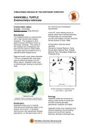
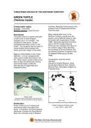
Flatback, Hawksbill <strong>and</strong> Olive Ridley Turtles have been<br />
confirmed nesting on mainl<strong>and</strong> beaches <strong>and</strong> some isl<strong>and</strong>s,<br />
but the area is especially significant for high density of<br />
nesting of Green Turtles. Isl<strong>and</strong>s within the Site support<br />
internationally significant breeding populations of Bridled<br />
<strong>and</strong> Roseate Terns, as well as significant numbers of other<br />
seabirds. A total of 18 threatened species have been<br />
recorded from within the Site, including three plant, 14<br />
vertebrate <strong>and</strong> one butterfly species (although there are no<br />
recent records for five of these species). A number of plant<br />
<strong>and</strong> vertebrate species occurring in the Site are restricted<br />
within the Northern Territory to the broader <strong>north</strong>-<strong>east</strong><br />
<strong>Arnhem</strong> region, which has interesting biogeographic<br />
affinities with Cape York <strong>Peninsula</strong>, Queensl<strong>and</strong>.<br />
Management Issues<br />
A range of management issues are affecting this area<br />
including increasing visitor pressure on sensitive <strong>coast</strong>al<br />
Google Earth imagery<br />
environments prone to erosion; degradation from vehicle<br />
traffic; localised impacts from bauxite mining; infestation<br />
by the exotic Yellow Crazy Ant; increases in Water<br />
Buffalo density <strong>and</strong> gradual spread of weeds from<br />
disturbed areas. Changed fire regimes <strong>and</strong> the impacts<br />
of commercial fishing <strong>and</strong> marine debris on marine<br />
turtles are also of concern. Dieback is evident in some<br />
vegetation communities, <strong>and</strong> feral cat, dog, horse, pig,<br />
Water Buffalo <strong>and</strong> cattle occur. There is a lack of<br />
comprehensive biodiversity data for much of this site<br />
<strong>and</strong> further systematic monitoring of significant seabird<br />
<strong>and</strong> turtle breeding sites is required.<br />
Condition<br />
Outside of the mining lease, this Site comprises a largely<br />
intact <strong>and</strong> weed-free savanna woodl<strong>and</strong> <strong>and</strong> dune<br />
system.<br />
Current Conservation Initiatives<br />
The <strong>north</strong>ern part of this site is in the Dhimurru<br />
Indigenous Protected Area <strong>and</strong> the southern part is in<br />
the Laynhapuy Indigenous Protected Area. Indigenous<br />
ranger groups based in Nhulunbuy <strong>and</strong> Yirrkala help to<br />
implement management priorities <strong>and</strong> are currently<br />
involved in a range of projects including management of<br />
access to recreational areas, weed <strong>and</strong> feral animal<br />
control (including the Yellow Crazy Ant eradication<br />
program), threatened species <strong>and</strong> marine debris<br />
surveys, as well as turtle recovery. Alcan <strong>Gove</strong> is<br />
currently undertaking a range of initiatives on or adjacent<br />
to the mining lease, <strong>and</strong> these include surveys <strong>and</strong><br />
monitoring of rehabilitation areas <strong>and</strong> other areas<br />
affected by mining operations.
GOVE PENINSULA AND NORTH-EAST ARNHEM COAST - SITE OF CONSERVATION SIGNIFICANCE<br />
Department of <strong>Natural</strong> <strong>Resources</strong>, Environment, The Arts <strong>and</strong> Sport 135
GOVE PENINSULA AND NORTH-EAST ARNHEM COAST - SITE OF CONSERVATION SIGNIFICANCE<br />
LOCATION<br />
THREATENED SPECIES<br />
ENDEMIC<br />
SPECIES<br />
WILDLIFE<br />
AGGREGATIONS<br />
SOCS Number<br />
24 (NT Parks <strong>and</strong> Conservation Masterplan Map Number 9)<br />
Latitude/Longitude 12º 38´ South, 136º 40´ East (at centre)<br />
Bioregion <strong>Arnhem</strong> Coast<br />
Description This site covers an area of 2285 km² <strong>and</strong> includes the <strong>coast</strong>al strip of <strong>north</strong>-<strong>east</strong> <strong>Arnhem</strong> L<strong>and</strong> extending<br />
from Bremer Isl<strong>and</strong> <strong>and</strong> Melville Bay southwards 150 km to Cape Shield, the <strong>north</strong>ern point of Blue Mud<br />
Bay. The <strong>coast</strong>line is a 570 km stretch of intricate bays <strong>and</strong> headl<strong>and</strong>s as well as long s<strong>and</strong>y beaches,<br />
<strong>and</strong> many small isl<strong>and</strong>s of rock <strong>and</strong> s<strong>and</strong> located close to the <strong>coast</strong> are also included within the site. The<br />
<strong>coast</strong>al l<strong>and</strong>forms are characterised by parabolic dune fields <strong>and</strong> beach ridge plains.<br />
Inl<strong>and</strong>, the site comprises much of the deeply weathered granite plains, associated lateritic <strong>and</strong> bauxitic<br />
plains <strong>and</strong> plateau that are distinctive to the region, as well as intervening alluvial plains (Lynch <strong>and</strong><br />
Wilson 1998). The western bounds of the site are not well defined.<br />
To the south, the site abuts Blue Mud Bay <strong>and</strong> its associated <strong>coast</strong>al floodplains, which are also<br />
recognised as a site of high conservation significance in the NT.<br />
Significance Rating International Significance<br />
Threatened plants<br />
<strong>and</strong> animals<br />
(Listings at<br />
National/NT level<br />
CR - Critically<br />
Endangered,<br />
EN - Endangered,<br />
VU - Vulnerable,<br />
NT - Near<br />
Threatened,<br />
LC - L<strong>east</strong> Concern,<br />
DD - Data Deficient)<br />
18 threatened species are reported from this site.<br />
Plants<br />
� Australian arenga palm Arenga australasica (VU/DD)<br />
� Hern<strong>and</strong>ia nymphaeifolia (-/VU)<br />
In the NT, restricted to NE <strong>Arnhem</strong> L<strong>and</strong> <strong>and</strong> Groote Eyl<strong>and</strong>t.<br />
� Ptern<strong>and</strong>ra coerulescens (-/VU)<br />
In the NT, restricted to NE <strong>Arnhem</strong> L<strong>and</strong>.<br />
Vertebrates<br />
� Australian Bustard Ardeotis australis (-/VU)<br />
� Emu Dromaius novaeholl<strong>and</strong>iae (-/VU)<br />
� Partridge Pigeon Geophaps smithii (VU/VU)<br />
� Red Goshawk Erythrotriorchis radiatus (VU/VU)<br />
� Brush-tailed Rabbit-rat Conilurus penicillatus (-/VU)<br />
� Golden B<strong>and</strong>icoot Isoodon auratus (VU/EN)<br />
� Northern Brush-tailed Phascogale Phascogale pirata (-/VU)<br />
� Northern Hopping-mouse Notomys aquilo (VU/VU)<br />
� Northern Quoll Dasyurus hallucatus (EN/CR)<br />
� Merten's Water Monitor Varanus mertensi (-/VU)<br />
� Flatback Turtle Natator depressus (VU/DD)<br />
� Green Turtle Chelonia mydas (VU/LC)<br />
� Hawksbill Turtle Eretmochelys imbricata (VU/DD)<br />
� Olive Ridley Turtle Lepidochelys olivacea (EN/DD)<br />
A number of these species (Rabbit-rat, Phascogale, Golden B<strong>and</strong>icoot, Red Goshawk, Partridge Pigeon)<br />
have not been recorded from mainl<strong>and</strong> NE <strong>Arnhem</strong> L<strong>and</strong> since the 1970s (Gambold et al. 1995), <strong>and</strong><br />
may not persist here. The persistence of Northern Quoll since the arrival of the Cane Toad is unknown.<br />
Invertebrates<br />
� <strong>Gove</strong> Crow Euploea alcathoe enastri (EN/EN). Restricted to NE <strong>Arnhem</strong> L<strong>and</strong> (Braby 2007)<br />
Significance Rating Regional Significance<br />
Notes Endemic to the site: The plant Solanum yirrkalense is known only from this site.<br />
Endemic to the bioregion: The <strong>Gove</strong> Crow butterfly is restricted to <strong>north</strong>-<strong>east</strong> <strong>Arnhem</strong> L<strong>and</strong> <strong>and</strong> is<br />
currently known only from ~six locations (three within this site) all associated with monsoon vine forest or<br />
tall mixed paperbark (Melaleauca spp.) forest with rainforest elements in the understorey (Braby 2007).<br />
Endemic to the NT: The site includes eight vertebrate <strong>and</strong> 52 plant species endemic to the NT.<br />
Other: The site includes two vertebrate <strong>and</strong> 20 plant species that are, within the NT, restricted to the<br />
<strong>Arnhem</strong> Coast bioregion.<br />
Significance Rating International Significance<br />
Marine turtles<br />
The mainl<strong>and</strong> beaches of <strong>north</strong>-<strong>east</strong> <strong>Arnhem</strong> L<strong>and</strong> from Cape <strong>Arnhem</strong> to Cape Shield (excluding inside<br />
the bays) provide internationally-important nesting habitat for marine turtles, including some of the<br />
densest <strong>and</strong> most extensive areas of turtle nesting in the NT (Chatto <strong>and</strong> Baker 2008). Flatback,<br />
Hawksbill <strong>and</strong> Olive Ridley Turtles have all been confirmed nesting, but the area is especially significant<br />
for high-density nesting of Green Turtles.<br />
Chatto <strong>and</strong> Baker (2008) also report that offshore isl<strong>and</strong>s along this stretch of <strong>coast</strong>, such as Bridgl<strong>and</strong><br />
<strong>and</strong> Dudley Isl<strong>and</strong>s, are significant for nesting Hawksbill Turtles. Occasional records of Leatherback<br />
Turtles have been reported in the waters of this area, but there are no confirmed nesting records in this<br />
site (R. Chatto, NRETAS, pers. comm.).<br />
Department of <strong>Natural</strong> <strong>Resources</strong>, Environment, The Arts <strong>and</strong> Sport 136
GOVE PENINSULA AND NORTH-EAST ARNHEM COAST - SITE OF CONSERVATION SIGNIFICANCE<br />
WETLANDS<br />
FLORA<br />
OTHER<br />
ENVIRONMENTAL<br />
VALUES<br />
MANAGEMENT ISSUES<br />
Seabirds<br />
The chain of small isl<strong>and</strong>s that run <strong>north</strong>-<strong>east</strong> of Nhulunbuy support significant colonies of breeding<br />
seabirds. Counts of 3,000 Roseate Terns <strong>and</strong> 10,000 Bridled Terns on Higginson Islet (colony # S030) in<br />
May 1994, <strong>and</strong> 2,500 Roseate Terns on East Bremer Islet (S032) in 1993 (Chatto 2001) are<br />
internationally significant (>1% global population; Dutson in prep.). Neighboring isl<strong>and</strong>s to the west <strong>and</strong><br />
south of Higginson Islet, also support significant breeding populations of Roseate, Black-naped, <strong>and</strong><br />
Bridled Terns (S033, S085, S0117) (Chatto 2001).<br />
The Three Hummocks Isl<strong>and</strong> group south of Wanyanmera Point, is also of international significance for<br />
breeding seabirds with 20,000 to 50,000 Bridled Terns (>1% global population; Dutson in prep.) recorded<br />
in 1999 (S039) (Chatto 2001). Smaller numbers of Bridled Terns <strong>and</strong> Roseate Terns have also been<br />
recorded nesting on adjacent isl<strong>and</strong>s (Chatto 2001).<br />
Chatto (2001) identified numerous other small <strong>and</strong> less significant seabird colonies on small isl<strong>and</strong>s<br />
associated with isl<strong>and</strong>s identified above, <strong>and</strong> near Port Bradshaw.<br />
Waterbirds No significant aggregations of waterbirds are known from this site, although Chatto (2006) does note 10<br />
individual waterbird records of importance, including three groups of ~800 Brolga in <strong>coast</strong>al areas of the<br />
site in late 1993.<br />
Shorebirds Only small <strong>and</strong> scattered areas of shorebird habitat occur in this site <strong>and</strong> just one important record of<br />
shorebirds is noted by Chatto (2003) - a flock of 3000 mixed wader species in Trial Bay.<br />
Other aggregations None known<br />
Significance Rating Not Significant<br />
Ramsar criteria met Not assessed<br />
DIWA criteria met Not assessed<br />
Notes There are no major wetl<strong>and</strong>s within the site, though local floodplains, paperbark swamps, mangrove<br />
forests <strong>and</strong> spring-fed rainforests are of regional significance.<br />
Rivers No major rivers flow through the <strong>Gove</strong> <strong>Peninsula</strong> <strong>and</strong> <strong>north</strong>-<strong>east</strong> <strong>Arnhem</strong> L<strong>and</strong> <strong>coast</strong> site, but it does<br />
cover a number of short near-pristine watercourses.<br />
Significance Rating National Significance<br />
Notes Rainforest: The <strong>north</strong>-<strong>east</strong> <strong>Arnhem</strong> Coast supports many patches of monsoon rainforest which occur<br />
behind the <strong>coast</strong>al s<strong>and</strong> dunes <strong>and</strong> are associated with springs <strong>and</strong> riparian zones. The majority of<br />
patches within this site are dry rainforest <strong>and</strong> are very small (100 ha (Russell-Smith 1991). Rainforest within this site comprises about 10 000 ha (or 4% of the NT<br />
rainforest estate), <strong>and</strong> many rainforest plant species are only found in the NT, in the broader <strong>north</strong>-<strong>east</strong><br />
<strong>Arnhem</strong> L<strong>and</strong> region (Liddle et al. 1994).<br />
Restricted range species: Many plant species, particularly within monsoon vine forests, are restricted<br />
within the NT to the broader <strong>north</strong>-<strong>east</strong> <strong>Arnhem</strong> L<strong>and</strong> region, <strong>and</strong> include elements common to Cape<br />
York.<br />
Three Hummocks Isl<strong>and</strong>, Higginson Islet, <strong>and</strong> other small islets <strong>north</strong> of Nhulunbuy, are proposed to be<br />
nominated by Birds Australia as internationally-recognised Important Bird Areas (G. Dutson in prep.) due<br />
to the occurrence of globally significant numbers of congregatory seabirds.<br />
There are 54 migratory animal species recorded from this site that are listed under international<br />
conventions or bilateral agreements.<br />
Five sites on the North-East <strong>Arnhem</strong> Coast are listed on the Register of the National Estate for their<br />
natural values, including Rocky Bay Jungle, Dalywoi Bay Monsoon Vine Forest, Holly Inlet Monsoon Vine<br />
Forest, Rindarry Jungles, <strong>and</strong> Yalangbara Monsoon Vine Forest (Australian Heritage Council).<br />
The Nhulunbuy area contains the richest, most extensive <strong>and</strong> diverse coral reefs of the NT which are<br />
possibly of national significance, but ~50% were destroyed by cyclone Ingrid in March 2005 (Gomelyuk<br />
2007). The marine areas within this site are likely to encompass other significant biodiversity values <strong>and</strong><br />
these are currently being explored <strong>and</strong> collated in a project by the Marine Biodiversity Group of NRETAS<br />
(K. Edyvane, NRETAS, pers. comm.).<br />
Fire: There are clear indications that fire regimes have changed, with consequent damage to firesensitive<br />
vegetation (Russell-Smith <strong>and</strong> Bowman 1992 in Gambold et al. 1995) <strong>and</strong>, presumably, the<br />
associated fauna. In the period 1993-2004, 93% of the site was burnt in fewer than three years, <strong>and</strong> none<br />
was burnt in more than six years.<br />
Feral animals: Concern about growing numbers of buffalo on the Lanaphuy homel<strong>and</strong>s prompted aerial<br />
surveys of buffalos in 2006. The surveys found that buffalos are present right across the Lanaphuy<br />
homel<strong>and</strong>s but are concentrated on the floodplains around Blue Mud Bay where densities have<br />
increased since surveys in 1998 (Saalfeld 2006). Cane Toads were noted at survey sites in the Arafura<br />
Swamp in the 2000/01 wet season (Brennan et al. 2003). There is a major infestation of Yellow Crazy<br />
Ants (Anoplolepis gracilipes) in <strong>north</strong>-<strong>east</strong> <strong>Arnhem</strong> L<strong>and</strong>, probably originating near Nhulunbuy in the<br />
1940s (CSIRO undated). Feral cat, dog, horse, pig <strong>and</strong> cattle also occur in the area.<br />
Weeds: Two Weeds of National Significance (Lantana camara <strong>and</strong> Salvinia molesta), 16 declared<br />
Category A <strong>and</strong> B weeds, <strong>and</strong> 6 undeclared but problematic environmental weeds (high priority weeds;<br />
Smith 2001) are recorded from this site. Other problematic species such as mission grass Pennisetum<br />
polystachion, are becoming established around the townships of Nhulunbuy <strong>and</strong> Yirrkala (Northern L<strong>and</strong><br />
Council 2004).<br />
Department of <strong>Natural</strong> <strong>Resources</strong>, Environment, The Arts <strong>and</strong> Sport 137
GOVE PENINSULA AND NORTH-EAST ARNHEM COAST - SITE OF CONSERVATION SIGNIFICANCE<br />
MANAGEMENT INFORMATION<br />
Other: The current operational lease of the bauxite mine extends over an area of around 205 km 2 with<br />
strip mining techniques used to extract the ore. Mining commenced in the early 1970s before<br />
environmental impact studies were required <strong>and</strong>, consequently, detailed baseline data is not available.<br />
Large areas are cleared for mining <strong>and</strong> while the company has invested heavily to develop <strong>and</strong><br />
implement revegetation strategies, detailed pre-clearing flora <strong>and</strong> fauna surveys have only recently been<br />
instituted. Limited subsequent surveys have revealed at l<strong>east</strong> one highly restricted <strong>and</strong> potentially<br />
threatened plant species (Erythroxylum sp. Cholmondely Creek (JR Clarkson 9367).<br />
Dieback of Darwin stringybark Eucalyptus tetrodonta was first reported in the Nhulunbuy Township area<br />
in 1981 <strong>and</strong> has occurred regularly since then in areas exposed to human intervention. A research<br />
project is proposed to investigate the causes <strong>and</strong> recommend management procedures (Matrix+<br />
Consulting 2007).<br />
Concerns have been expressed about conservation of marine turtles in the area, with indications of high<br />
mortality associated with commercial fishing industry (Gambold et al. 1995) as well as “ghost nets” <strong>and</strong><br />
other marine debris.<br />
While there is valuable historical data from the <strong>Gove</strong> area (Dixon <strong>and</strong> Huxley 1985; Officer 1976),<br />
systematic biological surveys in some parts of the site (Gambold et al. 1995) <strong>and</strong> targeted studies of<br />
some species (Woinarski et al. 1999), biodiversity data is sparse for much of this site.<br />
NRM groups Dhimurru Rangers (Nhulunbuy); Gamarrwa Numul L<strong>and</strong>care (Yirrkala) (Northern L<strong>and</strong> Council 2006).<br />
Protected areas Dhimurru Indigenous Protected Area (1118 km²/ 49% of site), Laynhapuy Indigenous Protected Area<br />
(1160 km² / 51% of site).<br />
Current<br />
management plans<br />
Monitoring<br />
programs <strong>and</strong><br />
research projects<br />
Management<br />
recommendations<br />
Site-specific plans: The Dhimurru IPA Management Plan (Dhimurru L<strong>and</strong> Management Aboriginal<br />
Corporation 2000) is currently under review http://www.dhimurru.com.au/plans.html<br />
Yolnguwu Monuk Gapu Plan of Management: A Yolngu Vision <strong>and</strong> Plan for Sea Country Management in<br />
North-<strong>east</strong> <strong>Arnhem</strong> L<strong>and</strong>, Northern Territory. (Dhimurru L<strong>and</strong> Management Aboriginal Corporation 2006)<br />
http://www.dhimurru.com.au/plans.html<br />
Laynhapuy Indigenous Protected Area Management Plan (draft) (Laynhapuy Homel<strong>and</strong>s Association<br />
Incorporated 2006).<br />
National recovery plans for threatened species: Partridge Pigeon (Woinarski 2004a); Golden<br />
B<strong>and</strong>icoot (Palmer et al. 2003); Northern Hopping Mouse (Woinarski 2004b); Northern Quoll (Hill <strong>and</strong><br />
Ward in prep.); marine turtles (Environment Australia 2003); <strong>Gove</strong> Crow (Braby 2006).<br />
Other management plans: Australian Weeds Strategy (NRMMC 2007); Threat Abatement Plan for<br />
Predation by Feral Cats (Environment Australia, 1999); Threat Abatement Plan for Predation, habitat<br />
degradation, competition <strong>and</strong> disease transmission by feral pigs (DEH 2005); Threat Abatement Plan to<br />
reduce the impacts of tramp ants on biodiversity in Australia <strong>and</strong> its territories (DEH 2006); FIREPLAN:<br />
Fire management for the savanna community (Russell-Smith et al. in prep.).<br />
Ad hoc reports documenting the incidence of vegetation dieback in the <strong>Gove</strong> area have been compiled<br />
since 1981 <strong>and</strong> a formal program was established in 2007 to monitor the extent <strong>and</strong> ecological impact of<br />
dieback in affected areas <strong>and</strong> some unaffected areas (Matrix+ Consulting 2006). A detailed research<br />
project is proposed to investigate the causes of vegetation dieback in the <strong>Gove</strong> area <strong>and</strong> recommend<br />
management procedures (Matrix+ Consulting 2007).<br />
Monitoring of rehabilitation sites occurred following mining between 1974 -1989 <strong>and</strong> then more recently<br />
(2005-2007) at a number of rehabilitation sites <strong>and</strong> intact control sites (Woinarski et al. 2005; Crase et al.<br />
2006; Crase et al. 2007).<br />
Long-term vertebrate fauna monitoring in post-mining rehabilitation sites <strong>and</strong> nearby unmined sites<br />
(Woinarski et al. 2008).<br />
Annual monitoring of vegetation characteristics at 12 riparian sites on <strong>and</strong> around the Alcan mining lease<br />
has occurred since 2004 to determine the impact of groundwater extraction (Crase et al. 2006).<br />
Indigenous rangers are involved in a range of programs to monitor marine turtles <strong>and</strong> marine debris<br />
including: annual marine debris surveys (NRETA 2007); annual helicopter surveys of fishing nets along<br />
the Dhimurru IPA <strong>coast</strong> since 1996; monitoring of turtle nest predation on Bremer Isl<strong>and</strong> commenced in<br />
2007 under the NAILSMA Dugong <strong>and</strong> Marine Turtle Project; <strong>and</strong> irregular survey <strong>and</strong> collection of<br />
fishing nets under the Carpentaria Ghost Net program since 2005. Plans are also in place to attach<br />
satellite transmitters to Olive Ridley turtles when they are found <strong>and</strong> released from nets (J. Dermer,<br />
Dhimurru L<strong>and</strong> Management Aboriginal Corporation, pers. comm.).<br />
Surveys of <strong>Gove</strong> Crow Butterfly habitat commenced in 2006 with an emphasis on reassessing known<br />
sites, finding new sites, <strong>and</strong> assessing threatening processes (M. Braby, NRETAS, pers. comm.).<br />
Permanent sites have been established off the <strong>coast</strong> of Nhulunbuy to monitor coral health (NRETA<br />
2007).<br />
Fire in the tropical savannas is mapped continuously under the North Australia Fire Information Project<br />
http://www.fire<strong>north</strong>.org.au/nafi/app/init.jsp<br />
Continue to work with Dhimurru L<strong>and</strong> Management Corporation <strong>and</strong> Lanypuy Homel<strong>and</strong>s Association<br />
Incorporated to resource <strong>and</strong> implement programs under the respective IPA management plans in<br />
accordance with the section 73 agreement (NRETA 2005).<br />
Support community ranger groups <strong>and</strong> assist with the development of their management capacity<br />
including a structured training program (NRETA 2005).<br />
Maintain the current Parks <strong>and</strong> Wildlife ranger presence <strong>and</strong> operational capacity providing wildlife<br />
management <strong>and</strong> coordination of training at Nhulunbuy (NRETA 2005).<br />
Monitor seabird nesting in significant colonies (G. Dutson in prep.).<br />
Department of <strong>Natural</strong> <strong>Resources</strong>, Environment, The Arts <strong>and</strong> Sport 138
GOVE PENINSULA AND NORTH-EAST ARNHEM COAST - SITE OF CONSERVATION SIGNIFICANCE<br />
KEY REFERENCES<br />
Papers <strong>and</strong> reports Chatto, R. <strong>and</strong> Baker, B. (2008). The distribution <strong>and</strong> status of marine turtle nesting in the Northern<br />
Territory. Technical Report 77. Parks <strong>and</strong> Wildlife Service, Northern Territory Department of <strong>Natural</strong><br />
<strong>Resources</strong>, Environment & the Arts, Darwin.<br />
Chatto, R. (2001). The distributions <strong>and</strong> status of colonial breeding seabirds in the Northern Territory.<br />
Technical Report 70, Parks <strong>and</strong> Wildlife Commission of the Northern Territory, Darwin. 206pp.<br />
Gambold, N., Woinarski, J.C., Brennan, K., Jackson, D., Mununggiritj, N., Wunungmurra, B., Yunupingu,<br />
D., Burarrwanga, N., Wearne, G. (1995). Fauna survey of the proposed Nanydjaka Reserve (Cape<br />
<strong>Arnhem</strong> <strong>Peninsula</strong>) with reference to the fauna of <strong>north</strong>-<strong>east</strong>ern <strong>Arnhem</strong> L<strong>and</strong>, Conservation Commission<br />
of the Northern Territory, Darwin.<br />
Officer, H.R. (1976). Ten days of observations of the birds of <strong>Gove</strong> <strong>Peninsula</strong>. Australian Bird Watcher 6,<br />
223-228.<br />
Woinarski, J., Hokkanen, R., Milne, D., <strong>and</strong> Armstrong, M. (2008). Long-term vertebrate fauna<br />
monitoring: Rio Tinto Alcan <strong>Gove</strong> Rehabilitation Monitoring. Report to Matrix+ (Department of <strong>Natural</strong><br />
<strong>Resources</strong>, Environment <strong>and</strong> The Arts, Darwin.)<br />
Contributors Alaric Fisher, Biodiversity Conservation, NRETAS, Darwin.<br />
Department of <strong>Natural</strong> <strong>Resources</strong>, Environment, The Arts <strong>and</strong> Sport 139