2008 Site Environmental Report for Pantex Plant
2008 Site Environmental Report for Pantex Plant
2008 Site Environmental Report for Pantex Plant

Create successful ePaper yourself
Turn your PDF publications into a flip-book with our unique Google optimized e-Paper software.
<strong>2008</strong> <strong>Site</strong> <strong>Environmental</strong> <strong>Report</strong> <strong>for</strong> <strong>Pantex</strong> <strong>Plant</strong><br />
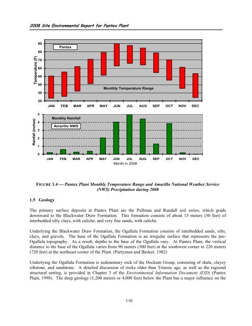
Temperature (F)<br />
Rainfall (inches)<br />
90<br />
80<br />
70<br />
60<br />
50<br />
40<br />
30<br />
20<br />
5<br />
4<br />
3<br />
2<br />
1<br />
0<br />
<strong>Pantex</strong><br />
Monthly Rainfall<br />
Amarillo NWS<br />
Monthly Temperature Range<br />
JAN FEB MAR APR MAY JUN JUL AUG SEP OCT NOV DEC<br />
JAN FEB MAR APR MAY JUN JUL AUG SEP OCT NOV DEC<br />
Month in <strong>2008</strong><br />
FIGURE 1.4 ⎯ <strong>Pantex</strong> <strong>Plant</strong> Monthly Temperature Range and Amarillo National Weather Service<br />
(NWS) Precipitation during <strong>2008</strong><br />
1.5 Geology<br />
The primary surface deposits at <strong>Pantex</strong> <strong>Plant</strong> are the Pullman and Randall soil series, which grade<br />
downward to the Blackwater Draw Formation. This <strong>for</strong>mation consists of about 15 meters (50 feet) of<br />
interbedded silty clays, with caliche, and very fine sands, with caliche.<br />
Underlying the Blackwater Draw Formation, the Ogallala Formation consists of interbedded sands, silts,<br />
clays, and gravels. The base of the Ogallala Formation is an irregular surface that represents the pre-<br />
Ogallala topography. As a result, depths to the base of the Ogallala vary. At <strong>Pantex</strong> <strong>Plant</strong>, the vertical<br />
distance to the base of the Ogallala varies from 90 meters (300 feet) at the southwest corner to 220 meters<br />
(720 feet) at the northeast corner of the <strong>Plant</strong>. (Purtymun and Becker, 1982)<br />
Underlying the Ogallala Formation is sedimentary rock of the Dockum Group, consisting of shale, clayey<br />
siltstone, and sandstone. A detailed discussion of rocks older than Triassic age, as well as the regional<br />
structural setting, is provided in Chapter 3 of the <strong>Environmental</strong> In<strong>for</strong>mation Document (EID) (<strong>Pantex</strong><br />
<strong>Plant</strong>, 1998). The deep geology (1,200 meters or 4,000 feet) below the <strong>Plant</strong> has a major influence on the<br />
1-10