

AgGPS MultiPlane software
AgGPS MultiPlane software
AgGPS MultiPlane software

Create successful ePaper yourself
Turn your PDF publications into a flip-book with our unique Google optimized e-Paper software.
Key Features<br />
And Benefits<br />
• Easy to use and learn<br />
user interface<br />
• Design control for<br />
Geostar control system<br />
• Design from topographic<br />
files collected with an<br />
Ag GPS 214 RTK receiver<br />
and Ag GPS 160 or<br />
Ag GPS 170 system<br />
• Imports industrystandard<br />
ESRI‚<br />
Shapefile format<br />
• Efficient design layout<br />
• Maps, job layout and<br />
estimates<br />
Ag GPS <strong>MultiPlane</strong><br />
Surface Drainage and Land Leveling Design Software<br />
For years farmers have been<br />
improving their crop yields by<br />
using laser systems to level their<br />
fields for uniform drainage and<br />
runoff. The consistent water flow<br />
over the crops improves crop<br />
yields and ground consistency,<br />
which improves profits. <strong>AgGPS</strong> ®<br />
<strong>MultiPlane</strong> ® <strong>software</strong> is a tool<br />
used to help design drainage<br />
slopes for crop fields that can<br />
be graded with minimal dirt<br />
movement.<br />
<strong>MultiPlane</strong> <strong>software</strong> is<br />
designed to work with the<br />
Trimble GeoStar ® land forming<br />
system or a Trimble <strong>AgGPS</strong><br />
Field Information System* with<br />
an <strong>AgGPS</strong> 214 RTK high accuracy<br />
GPS receiver.<br />
<strong>MultiPlane</strong> <strong>software</strong> reads<br />
field topographic surveys collected<br />
with an <strong>AgGPS</strong> Field<br />
Information System and <strong>AgGPS</strong><br />
214 receiver or GeoStar system<br />
and builds an existing surface<br />
model from the survey.<br />
Use <strong>MultiPlane</strong> <strong>software</strong> to<br />
help you design how you want<br />
to level the field. Look at 3-D<br />
views of your field. Then use<br />
the slope information to set<br />
your laser for grading, or export<br />
the cut and fill design to a control<br />
file that the GeoStar system<br />
uses to automatically grade the<br />
field. Fields can be designed to<br />
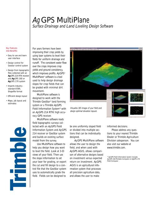
Visualise 3D images of your field and<br />
design optimal elevation layouts<br />
be one uniformly sloped field<br />
or divided into multiple sections<br />
that can be individually<br />
designed.<br />
Ag GPS <strong>MultiPlane</strong> <strong>software</strong><br />
allows the user to design the<br />
field, and when used with<br />
<strong>AgGPS</strong> AGIS, allows comparison<br />
of alternative designs based<br />
on investment versus expected<br />
return on investment. <strong>AgGPS</strong><br />
AGIS is an agricultural information<br />
system that processes<br />
all precision agriculture data,<br />
and allows the user to make<br />
informed decisions.<br />
Please address any questions<br />
to your nearest Trimble<br />
Dealer or Trimble Agriculture<br />
Division salesperson. You can<br />
also visit our website at<br />
www.trimble.com.<br />
* Ag GPS Field Information System includes<br />
Ag GPS 160 Portable Computer or <strong>AgGPS</strong> 170<br />
Field Computer
Ag GPS <strong>MultiPlane</strong><br />
Surface Drainage and Land Leveling Design Software<br />
STANDARD FEATURES<br />
• Imports Shapefile through support of our Shape-to-Multiplane converter<br />
• Imports industry standard files: Shape, DXF, and Generic Text files<br />
• Surface Builder creates topography<br />
• Best Fit Design<br />
• Single Plane Design<br />
• Fixed Elevation Design<br />
• Automatic Elevation Design<br />
• Support of Section Lines and Hinges<br />
• Direct support of Ag GPS 214 when used with Ag GPS 160 Portable<br />
Computer or Ag GPS 170 Field Computer or when used with Geostar<br />
system<br />
ASSOCIATED SOFTWARE<br />
We recommend these <strong>software</strong> packages:<br />
• WinZip from NicoMak Software to compress data for transfers<br />
and storage<br />
• Ag GPS AGIS/ViewPoint for display and analysis of topographic<br />
data and yield analysis compared to design.<br />
SYSTEM REQUIREMENTS<br />
Computer<br />
CPU: Intel Pentium III or equivalent<br />
System Memory<br />
(RAM): 128MB recommended. Note that system memory<br />
requirement changes with operating system choice<br />
Video Card: Capable of 16-, 24-, or 32-bit color operation<br />
CD Drive: Recommended for <strong>software</strong> installations<br />
CD Writer: Optional but useful<br />
Operating System<br />
• Win95 with Service pak #2 (Our system memory recommendation<br />
is 32 MB)<br />
• Win 98 (Microsoft’s system memory recommendation is 64 MB)<br />
• Windows NT with Service Pak #4 (Our system memory<br />
recommendation is 128 MB)<br />
• Win 2000 (Microsoft’s system memory recommendation is 256 MB)<br />
Trimble Navigation Limited<br />
Corporate Headquarters<br />
645 North Mary Avenue<br />
Sunnyvale, CA 94086<br />
(408) 481-8000<br />
(408) 481-2082 Fax<br />
www.trimble.com<br />
Trimble Navigation Limited<br />
Agriculture Division<br />
9290 Bond Street, Suite 102<br />
Overland Park, KS 66214<br />
(913) 495-2700<br />
(913) 495-2750 Fax<br />
precision_ag@trimble.com<br />
ORDERING INFORMATION<br />
<strong>AgGPS</strong> <strong>MultiPlane</strong> v1.4 PN: 0310-4000 (Order from Dayton)<br />
<strong>AgGPS</strong> Shape to <strong>MultiPlane</strong><br />
Converter: PN 505MPC<br />
<strong>AgGPS</strong> <strong>MultiPlane</strong><br />
Annual Support: PN 505MPA<br />
<strong>AgGPS</strong> 160 Portable Computer: PN 44940-00<br />
<strong>AgGPS</strong> 170 Field Computer: PN 38381-00<br />
<strong>AgGPS</strong> High Accuracy Topo<br />
System with <strong>AgGPS</strong> 170: PN 40104-10<br />
<strong>AgGPS</strong> 214 Base Station System: PN 38860-50<br />
TrimComm 900M Base radio: PN 34411-50<br />
Purchase the full <strong>software</strong> via your nearest Trimble Dealer. You will<br />
need to provide the dealer with your name and contact details including<br />
e-mail address. You will also need to provide the System ID numbers<br />
that will allow the <strong>software</strong> to be fully activated.<br />
For further information please contact your nearest Trimble Authorized<br />
Distributor or Trimble Office. You may also visit our website at<br />
www.trimble.com.<br />
Trimble Navigation Limited<br />
Agriculture Division<br />
5475 Kellenburger Road<br />
Dayton, OH 45424-1099<br />
(937) 233-8921<br />
(937) 233-0884 Fax<br />
Your Local Trimble Office or Representative<br />
© Copyright 2001, Trimble Navigation Limited. All rights reserved. <strong>AgGPS</strong>, GeoStar and <strong>MultiPlane</strong> are trademarks of Trimble Navigation Limited registered in the U.S. Patent and Trademark Office. The Globe and Triangle,<br />
and Trimble are trademarks of Trimble Navigation Limited. All other trademarks are the property of their respective owners. TID 12796 (9/01)