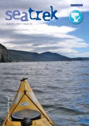
Sea Trek Issue 70 - Victorian Sea Kayak Club
Sea Trek Issue 70 - Victorian Sea Kayak Club
Sea Trek Issue 70 - Victorian Sea Kayak Club

You also want an ePaper? Increase the reach of your titles
YUMPU automatically turns print PDFs into web optimized ePapers that Google loves.
metre or so. After that, the chop settled<br />
in, the westerly settled in and we had no<br />
choice but to grit our teeth and settle<br />
ourselves in for the long haul. The sight<br />
of a nearing Townsend Point was a Godsend,<br />
but our spirits rose further when we<br />
realised that a small wind shift had occurred<br />
– a small but very helpful swing to<br />
the south. Rounding Townsend Point, it<br />
was “break out your sails boys” and we<br />
paddle/sailed our way to familiar territory,<br />
the outline of Bentley Point evoking<br />
the ancient VSKC folklore tale of the day<br />
current President Terry first photographed<br />
the Bentley Point Blowhole.<br />
Ah the Cattlemen’s Huts – flushing toilets<br />
and brand new mattresses that (then)<br />
didn’t smell strongly of horses (by the<br />
June 2011 long weekend they did, unfortunately).<br />
A roaring fire, more low quality<br />
music and an early night (“put that<br />
ukulele away Treasure or we’ll surgically<br />
insert it where it’ll never trouble the<br />
VSKC membership again”) and we slept,<br />
dreaming of the forecast conditions for<br />
the next day.<br />
Wow – when we luck out, we totally luck<br />
out. We awoke to a day that the Whitsundays<br />
can’t hope to match. Not even<br />
receding tide to prevent an assault on<br />
Granite Island could dampen our spirits.<br />
Lunch at Tinmine (no, Terry, Treasure<br />
didn’t sit on the native pigface ....... this<br />
time). Treasure found huge fish swimming<br />
around the reef at the north end of<br />
Tinmine – the plan was to get the camera<br />
ready, roll under, get as many close ups<br />
as possible and then roll up – the result<br />
was one very blurry close up photo followed<br />
by shots of a deserted reef (lacks<br />
subtlety our Treasure but at least this<br />
time he didn’t leave his prescription sunnies<br />
in 30 feet of crystal clear water ...)<br />
A well-received lunch, a chat with some<br />
fishermen and a moderate easterly breeze<br />
to aid our trip north to Welshpool and we<br />
were away. Paddle-sailing in a strong<br />
cross breeze, we were generating a bowwave<br />
indicative of 8 or 9 knots. What?<br />
The GPS says 2 knots – wow, what a<br />
tidal flow. However, when we reached<br />
the corner near Biddy’s, the tide flow<br />
was now side on – in 100 metres, speed<br />
across the bottom jumped from 2.1 knots<br />
to 8.5 knots. Yippee – this is living.<br />
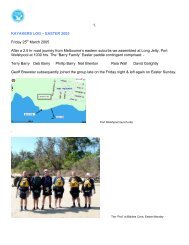
We rocketed home to Welshpool, to find<br />
<strong>Club</strong> local Lyn Atkinson on the beach<br />
having herself done the best of the<br />
Nooramunga National Park to enjoy the<br />
day. Thankfully, she obliged by taking<br />
the mandatory trip end photos (neither<br />
engineers nor accountants can operate the<br />
time delay facility on a digital camera).<br />
Greg Gleeson<br />
Yep, Richard, you were right about the<br />
trip – what a cracker ....”<br />
_________________________________<br />
FACT SHEET by Derek Wilson<br />
EASE OF PADDLE<br />
This is a relatively easy paddle with<br />
modest daily distances - particularly if<br />
one spends 3 days on it as we did. As<br />
ever, however, the ease of the paddle<br />
depends very much on the weather conditions<br />
on the day. Prevailing westerly<br />
winds mean that one paddles to the west<br />
end with wind behind – great fun – but<br />
you have to paddle back again!<br />
THINGS TO LOOK OUT FOR:<br />
Tides: Parts of the Nooramunga channel<br />
between Snake Island and the mainland<br />
are very shallow. “Middle ground”<br />
(where the tide meets from opposite directions)<br />
is approximately one third of<br />
the distance from Port Welshpool to the<br />
Port Albert entrance. At low tide, the<br />
middle ground is almost all dry land.<br />
The best bet is to try to hit middle ground<br />
at high tide so that you can enjoy tidal<br />
assist from the incoming tide between<br />
Port Welshpool and middle ground and<br />
tidal assist from the ebb tide between<br />
middle ground and the Port Albert entrance<br />
(or vice versa if you are going the<br />
other way).<br />
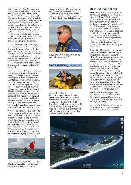
Camp site: There are only two marked<br />
camp sites on the Parks Victoria map of<br />
Snake Island – both at the west end.<br />
Although one can camp anywhere on the<br />
island (with a permit from Parks Victoria)<br />
there are not many suitable spots to<br />
camp at the east end of the Island. After<br />
camping on a previous trip at the East<br />
end of Snake Island itself, we were<br />
tempted this time by reports of a camp<br />
site on the second of the two little islands<br />
at the east end of Snake Island itself.<br />
However, the coordinates we were given<br />
(in an apparent clearing in the satellite<br />
photo) turned out to be a swamp! The<br />
actual camp site is shown on the attached<br />
image from Google Earth and may be<br />
found at 38 44.789 S 146 38.181 E.<br />
Other: Beware of the large exposed<br />
sand flats at low tide that can result in<br />
fairly lengthy portages if you get your<br />
timing wrong. .The sand bars in the area<br />
are subject to change.<br />
At Easter 2011, the sandy spit shown in<br />
the image below to the east of the easternmost<br />
little island was not present.<br />
9