VIIRS Geolocation (GEO) Sensor Data Record (SDR) - Nasa
VIIRS Geolocation (GEO) Sensor Data Record (SDR) - Nasa
VIIRS Geolocation (GEO) Sensor Data Record (SDR) - Nasa

You also want an ePaper? Increase the reach of your titles
YUMPU automatically turns print PDFs into web optimized ePapers that Google loves.
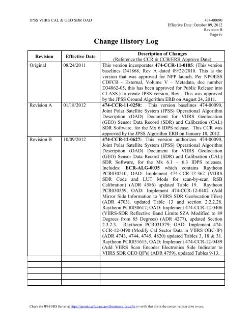
JPSS <strong>VIIRS</strong> CAL & <strong>GEO</strong> <strong>SDR</strong> OAD 474-00090<br />
Effective Date: October 09, 2012<br />
Revision B<br />
Page iv<br />
Change History Log<br />
Revision Effective Date<br />
Description of Changes<br />
(Reference the CCR & CCB/ERB Approve Date)<br />
Original 08/24/2011 This version incorporates 474-CCR-11-0105: (This version<br />
baselines D41868, Rev A dated 09/22/2010. This is the<br />
version that was approved for NPP launch. Per NPOESS<br />
CDFCB - External, Volume V – Metadata, doc number<br />
D34862-05, this has been approved for Public Release into<br />
CLASS.) to create JPSS version, Rev-. This was approved<br />
by the JPSS Ground Algorithm ERB on August 24, 2011.<br />
Revision A 01/18/2012 474-CCR-11-0250: This version baselines 474-00090,<br />
Joint Polar Satellite System (JPSS) Operational Algorithm<br />
Description (OAD) Document for <strong>VIIRS</strong> <strong>Geolocation</strong><br />
(<strong>GEO</strong>) <strong>Sensor</strong> <strong>Data</strong> <strong>Record</strong> (<strong>SDR</strong>) and Calibration (CAL)<br />
<strong>SDR</strong> Software, for the Mx 6 IDPS release. This CCR was<br />
approved by the JPSS Algorithm ERB on January 18, 2012.<br />
Revision B 10/09/2012 474-CCR-12-0627: This version authorizes 474-00090,<br />
Joint Polar Satellite System (JPSS) Operational Algorithm<br />
Description (OAD) Document for <strong>VIIRS</strong> <strong>Geolocation</strong><br />
(<strong>GEO</strong>) <strong>Sensor</strong> <strong>Data</strong> <strong>Record</strong> (<strong>SDR</strong>) and Calibration (CAL)<br />
<strong>SDR</strong> Software, for the Mx 6.1 – 6.3 IDPS releases.<br />
Includes: ECR-ALG-0035 which contains Raytheon<br />
PCR030210; OAD: Implement 474-CCR-12-362 (<strong>VIIRS</strong><br />
<strong>SDR</strong> Code and LUT Mods for scan-by-scan RSB<br />
Calibration) (ADR 4586) updated Table 19. Raytheon<br />
PCR030559, OAD: Implement 474-CCR-12-0402 (Add<br />
Mirror Side Information to <strong>VIIRS</strong> <strong>SDR</strong> <strong>Geolocation</strong> Files)<br />
(ADR 4703), updated Table 13 and section 2.2.2.28.<br />
Raytheon PCR030617; OAD: Implement 474-CCR-12-0406<br />
(<strong>VIIRS</strong>-<strong>SDR</strong> Reflective Band Limits SZA Modified to 89<br />
Degrees from 85 Degrees) (ADR 4277), updated Section<br />
2.3.2.3. Raytheon PCR031579; OAD: Implement 474-<br />
CCR-12-0490 (Modify Cal Sector <strong>Data</strong> in <strong>VIIRS</strong> OBC-IP)<br />
(ADR 4743, 4744, 4745, 4820) updated Tables 3, 18 & 31.<br />
Raytheon PCR031615, OAD: Implement 474-CCR-12-0489<br />
(Add <strong>VIIRS</strong> Scan Encoder Electronics Side Indicator to<br />
<strong>VIIRS</strong> <strong>SDR</strong> <strong>GEO</strong> QF's) (ADR 4759), updated Tables 9-13.<br />
Check the JPSS MIS Server at https://jpssmis.gsfc.nasa.gov/frontmenu_dsp.cfm to verify that this is the correct version prior to use.