Quantans Hill scoping report - E.ON UK
Quantans Hill scoping report - E.ON UK
Quantans Hill scoping report - E.ON UK

Create successful ePaper yourself
Turn your PDF publications into a flip-book with our unique Google optimized e-Paper software.
<strong>Quantans</strong> <strong>Hill</strong> Wind Farm<br />
Environmental Impact<br />
Assessment<br />
Scoping Report<br />
September 2011
<strong>Quantans</strong> <strong>Hill</strong> Wind Farm Project<br />
Environmental Impact Assessment Scoping Report<br />
September 2011<br />
This Report Has Been Compiled By<br />
The Natural Power Consultants Ltd.<br />
The Green House, Forrest Estate, Dalry,<br />
Castle Douglas, DG7 3XS,<br />
www.naturalpower.com
Contents Page<br />
1 Introduction 1<br />
1.1 The Developer 1<br />
1.2 Proposed Development 1<br />
1.3 Structure of This Report 2<br />
2 Project Description 2<br />
2.1 Initial Site Selection 2<br />
2.2 Site Location 2<br />
2.4 Site Description 2<br />
2.5 Wind farm Components and Installation 3<br />
2.6 Meteorological Mast 4<br />
2.7 Site Tracks and Borrow Pits 4<br />
2.8 Use of Construction Method Statements 4<br />
2.9 Grid Connection 5<br />
2.10 Operational Period 5<br />
2.11 Decommissioning 6<br />
2.12 Scoping Opinion 6<br />
3 General Approach to the EIA 6<br />
3.1 EIA Process 6<br />
3.2 Temporal Scope 7<br />
3.3 Spatial Scope 7<br />
3.4 Establishment of Baseline 7<br />
3.5 Prediction and Evaluation of Impacts and Effects 7<br />
3.6 Mitigation of Environmental Effects 8<br />
3.7 Consultation 9<br />
4 Environmental Assessment 9<br />
4.1 Compliance with Policies and Plans 9<br />
4.2 Landscape and Visual Assessment 10<br />
4.2.1 The Baseline Study 11<br />
4.2.2 Operational Stage Impacts 11<br />
4.2.3 Cumulative Visual and Landscape Effects 12<br />
4.3 Ecology 12<br />
4.3.1 Phase 1 Habitat Survey 13<br />
4.4 Hydrology, Hydrogeology and Geology 16<br />
4.5 Noise and Shadow Flicker 17<br />
4.6 Archaeology Assessment 17<br />
4.7 Existing Infrastructure Assessment 18
<strong>Quantans</strong> <strong>Hill</strong> Wind Farm<br />
4.8 Traffic Assessment and Safety 18<br />
4.9 Socio-economic and Tourism Assessment 19<br />
4.10 Land Use Change and Management 19<br />
5 Conclusions 19<br />
Figure 1: Indicative Wind Farm Development Area 21<br />
Figure 2: Regional Context Map 22
1 Introduction<br />
Page 1 of 22<br />
<strong>Quantans</strong> <strong>Hill</strong> Wind Farm<br />
This document has been prepared by Natural Power Consultants Ltd (Natural Power) on behalf of E.<strong>ON</strong><br />
Climate and Renewables Ltd (ECR) in anticipation of an application under Section 36 of the Electricity Act<br />
1989 for a wind farm at <strong>Quantans</strong> <strong>Hill</strong>, Dumfries and Galloway.<br />
Under the statutory procedures set out in the Electricity Works (Environmental Impact Assessment) (Scotland)<br />
Regulations 2000 and the Environmental Impact Assessment (Scotland) Regulations 1999 it is proposed that<br />
any such application is accompanied by a full Environmental Statement (ES).<br />
ECR’s preferred approach is that the scope for the Environmental Impact Assessment (EIA) be agreed with all<br />
relevant authorities.<br />
1.1 The Developer<br />
The application will be prepared by Natural Power on behalf of ECR. ECR is part of the E.<strong>ON</strong> Group, one of<br />
the world’s leading power and gas companies. Here in the <strong>UK</strong>, E.<strong>ON</strong> supply energy to more than 5 million<br />
customers and generate enough electricity for around 8million homes and employ 12,000 people.<br />
In 2007, E.<strong>ON</strong> set up E.<strong>ON</strong> Climate & Renewables, a global business that develops new, cleaner ways of<br />
developing energy. In the <strong>UK</strong>, ECR are focusing on developing onshore and offshore wind farms, biomass<br />
plants and marine energy technologies. At present E.<strong>ON</strong> own and operate 18 onshore wind farms and 3<br />
offshore wind farms. Together, these produce more than 400 megawatts (MW) of renewable electricity.<br />
1.2 Proposed Development<br />
The developers are proposing the construction of a wind farm of up to 90MW, to be located around <strong>Quantans</strong><br />
<strong>Hill</strong>, near Carsphairn in Dumfries and Galloway as shown in Figure 2.<br />
The wind farm would comprise:<br />
� Between 17-30 turbines;<br />
� Anemometer masts; and<br />
� Internal tracks and access to the road network.<br />
The wind farm will require a connection to the grid network. Although not envisaged at present, any section of<br />
overhead line associated with this connection would be subject to a separate application under Section 37 of<br />
the Electricity Act 1989.
1.3 Structure of This Report<br />
This <strong>report</strong> is structured as follows:<br />
Page 2 of 22<br />
<strong>Quantans</strong> <strong>Hill</strong> Wind Farm<br />
� Section 2 provides a brief description of the proposed development;<br />
� Section 3 describes the general approach that will be taken in carrying out the EIA; and<br />
� Section 4 sets out the assessment methodology that will be used to assess the impacts for each<br />
environmental topic.<br />
2 Project Description<br />
2.1 Initial Site Selection<br />
The proposed development upon <strong>Quantans</strong> <strong>Hill</strong> was identified by ECR following a rigorous site selection<br />
process initiated in 2008. A desktop assessment was initially undertaken to establish the potential for the<br />
development of wind energy in the area. These studies were followed in spring 2009 with more in depth<br />
analysis of the potential site along with consultations with the relevant authorities and discussions with<br />
landowners.<br />
A series of specific acceptance criteria was applied to the potential site relating to various issues, such as;<br />
planning considerations, wind resource, ecology considerations, access, grid connection, designations,<br />
potential noise sensitivities, existing infrastructure and terrain. If any areas failed to meet any of the<br />
acceptance criteria then it was excluded from further site progression. The ES will include the detailed site<br />
selection process and justification for the final site selection.<br />
2.2 Site Location<br />
The proposal would be sited close to the summit and surrounds of <strong>Quantans</strong> <strong>Hill</strong>. The site is located<br />
approximtaley 1.3km to the east of Carsphairn, just off the B729 in Dumfries and Galloway, Scotland. The<br />
national grid reference of the site centre is E 259000, N 594000 (NX590940). A site location plan is provided<br />
as Figure 1.<br />
2.4 Site Description<br />
The <strong>Quantans</strong> <strong>Hill</strong> site comprises approximately 816 hectares of upland farmland used primarily for sheep and<br />
cattle grazing. The holding is located on a south facing topographic slope surrounded by several hills. The<br />
closest two of these are Craig of Knockgray and Knockwhirn, which rise to 383m and 498m AOD.<br />
There are a number of small burns that run through the site towards the Water of Deugh, located at the<br />
bottom of the valley, adjacent to the southwest boundary. A large coniferous woodland plantation borders the<br />
site to the east, while to the south the land slopes away to farmland with more abundant wooded areas (both<br />
broadleaved and coniferous) which is more lowland in character. To the north and west of the site, the land
Page 3 of 22<br />
<strong>Quantans</strong> <strong>Hill</strong> Wind Farm<br />
rises steeply to a number of rounded hill tops, with habitats in those adjacent areas appearing relatively<br />
similar to those within the site.<br />
2.5 Wind farm Components and Installation<br />
The final wind farm components would not be finalised until all necessary statutory consents are in place.<br />
Therefore, the ES will consider all of the likely components and corresponding methods of installation. For the<br />
purpose of undertaking the environmental impact assessment a worst-case scenario will be considered for all<br />
aspects of the construction, operation and decommissioning of the wind farm.<br />
Construction of the wind farm would involve the following elements:<br />
� highway access/vehicle movements on and off-site;<br />
� temporary construction compound;<br />
� construction of new site tracks and upgrading of sections of existing tracks;<br />
� construction of turbine base foundations and crane pads;<br />
� erection of the structures (turbines, anemometry masts and transformers);<br />
� laying of on-site cabling;<br />
� site reinstatement;<br />
� construction of the control building with septic tank and substation compound; and<br />
� grid connection.<br />
2.5.1 Wind Turbines<br />
The <strong>Quantans</strong> <strong>Hill</strong> development could potentially accommodate the installation of approximately 30 turbines.<br />
The turbines will be of a modern design and will all be of similar size and type with three blades mounted on a<br />
horizontal axis passing through a nacelle housing the generator, gearbox and other operating equipment.<br />
The nacelles will be mounted on a tubular tower which allows access to the nacelle. The turbine towers will<br />
be of a maximum height of 80m, and an indicative diameter of the blades would be 90m giving a total height<br />
to blade tip of 125m. The final turbine colour would be decided in consultation with the regulatory authorities.<br />
The rotor blades will start to turn in wind speeds of between 2 and 5 m/s and optimum power output for the<br />
class of turbines envisaged for this site is generally achieved at around 12-15 m/s. Turbines will generally<br />
shut down once wind speeds exceed 25 m/s for safety reasons. Power is controlled automatically as wind<br />
speed varies. All rotor blades on the wind turbines within the wind farm will rotate in the same direction, i.e.<br />
clockwise when viewed from the windward direction.
2.5.2 Foundations<br />
Page 4 of 22<br />
<strong>Quantans</strong> <strong>Hill</strong> Wind Farm<br />
Gravity foundations are envisaged at present for the turbines. This foundation type makes use of a concrete<br />
base plate, with fill material placed and compacted over the foundation. The base tower section of the turbine<br />
is connected to the foundation either via an embedded end can which is cast into the foundation or<br />
alternatively by using holding down bolts that are cast into the upstand section of the foundation. Stability of<br />
the turbine is provided through the weight of the foundation and the material replaced over it.<br />
2.6 Meteorological Mast<br />
Wind farm performance would be remotely monitored using permanent anemometer masts together with a<br />
Systems Control and Data Acquisitions (SCADA) unit. The masts would be up to 80m free-standing lattice<br />
towers and would accommodate the anemometry equipment.<br />
2.7 Site Tracks and Borrow Pits<br />
Site tracks would be required to link the turbines to the public road network. On Figure 1 the proposed access<br />
corridor is shown with a hatched area identifying additional survey area. It has been identified that a wider<br />
access corridor than that envisaged by ECR at the projects inception is now required to access the turbine<br />
development area at <strong>Quantans</strong> <strong>Hill</strong>.<br />
It is recognised that in order to fully assess the revised access corridor the extent of the ecology study area<br />
may need to be increased. A meeting was held on the 12th October 2011 with SNH to review the ecology<br />
studies undertaken to date and establish any additional survey requirements. SNH are currently reviewing<br />
these studies and if any additional surveys are identified the results would be fed into the EIA assessment and<br />
<strong>report</strong>ed in the ES.<br />
The site tracks connecting turbines within the turbine development area would be chosen to minimise<br />
potential impacts on the environment, and the ES will include rationale for their location.<br />
The ES will also include details of the proposed locations for on-site borrow pits as well as restoration<br />
objectives.<br />
2.8 Use of Construction Method Statements<br />
Construction method statements would be developed to ensure the impacts from construction are kept to a<br />
practical minimum. The CMS would be agreed prior to construction with SNH and D&G Council. The<br />
documents would set out the measures that would be undertaken by Contractors to ensure good site practice
Page 5 of 22<br />
<strong>Quantans</strong> <strong>Hill</strong> Wind Farm<br />
with regards to the environment. Such measures would include for the transport and storage of potentially<br />
polluting substances such as oils and lubricants as well as waste management.<br />
2.9 Grid Connection<br />
As described above in Section 1.2, the wind farm development would use spare capacity on the local<br />
distribution system, with negotiations currently underway with Scottish Power.<br />
On-site cabling linking turbines to on-site substation would be placed in trenches and generally follow the<br />
route of on-site tracks.<br />
2.10 Operational Period<br />
The majority of the operation of the wind farm would be automatic. Each individual turbine would operate<br />
independently from the remainder of the turbines. Within the operational wind speed range the pitch angle of<br />
the turbine blades of each individual turbine would be automatically adjusted by the control system within the<br />
turbine, as appropriate for the measured wind speed. Should sensors, placed within the nacelle of the<br />
turbine, register any instability in the structure or any other malfunction in operation or should wind speeds<br />
increase over safe limits, then the turbine would be automatically shut down. If the cause of the shut down<br />
were high wind speeds then the turbine would automatically begin operation again once average wind speeds<br />
fell to within the operational range once more. Under other causes of shutdown the turbine would remain<br />
shut down and in a safe condition until manually restarted by a member of the operations and maintenance<br />
team.<br />
The lifetime of the project would be 25 years from commissioning. Turbines are generally designed with a<br />
warranty life of 25 years. However, to ensure that turbines continue to operate with acceptable availability in<br />
addition to maintenance in the event of malfunctions, regular pre-planned maintenance and servicing<br />
programmes are performed at the site on each turbine. Minor scheduled maintenance checks tend to be<br />
carried out every 6-months with major services being performed annually throughout the lifetime of the<br />
turbine. Each turbine would contain lubricating and hydraulic oils. These are changed during regular<br />
maintenance operations. In the unlikely event of a lubricant leak the fully sealed tower bottom would act as a<br />
bund containing the spillage until it can be cleaned up.<br />
Storage of other potentially polluting substances at the site during the operational period of the wind farm<br />
would only take place where agreed with the relevant authorities.<br />
An operations building will be required throughout the operation phase. The building will consist of office and<br />
welfare facilities as well as a compound area to store equipment, spares and substances. An indicative
Page 6 of 22<br />
<strong>Quantans</strong> <strong>Hill</strong> Wind Farm<br />
location, configuration, finish and drainage arrangements of the operations building would be included in the<br />
ES.<br />
2.11 Decommissioning<br />
At the end of the wind farm's useful life it is proposed that the turbines, transformers and other infrastructure<br />
would be removed. The upper sections of the turbine foundations would be removed and back filled with<br />
minimum 100-150 mm of appropriate material, peat or topsoil replaced, and the area reseeded. Tracks would<br />
be left to grass over or covered with soil and reseeded. At least six months prior to the decommissioning of<br />
the site a Decommissioning Method Statement would be prepared and agreed with Dumfries and Galloway<br />
Council.<br />
2.12 Scoping Opinion<br />
Evolving good practice in the planning system and national level encouragement to focus the content of EIAs<br />
and ES’s on the key issues identified at the <strong>scoping</strong> stage means ECR intend to specifically concentrate on<br />
key issues raised through this <strong>scoping</strong> consultation process.<br />
Should any consultees require any further information on the <strong>Quantans</strong> <strong>Hill</strong> proposal then ECR and Natural<br />
Power would be keen to discuss their requirements.<br />
3 General Approach to the EIA<br />
EIA is a statutory procedure which ensures that likely impacts of new development on the environment are<br />
fully appraised and taken into account in the decision making process. It also provides an opportunity to<br />
‘design out’ adverse environmental effects at an early stage – prevention or avoidance at the outset are<br />
considered generally preferable to mitigation or remedy at a later stage.<br />
3.1 EIA Process<br />
The environmental impacts of the scheme will be predicted for each of the environmental topics by comparing<br />
the baseline environmental conditions with the conditions that would prevail were the scheme to be<br />
constructed and operated. The environmental effects of the scheme will be predicted in relation to<br />
environmental receptors (i.e. people), built resources and natural resources.<br />
A distinction will be made in the assessments between impacts and effects, where:
Page 7 of 22<br />
<strong>Quantans</strong> <strong>Hill</strong> Wind Farm<br />
� Impacts are defined as the predicted change to the baseline environment attributable to the scheme;<br />
and<br />
� Effects are the consequence of impacts on environmental resources or receptors.<br />
3.2 Temporal Scope<br />
The EIA will address the construction phase, the operational phase which would last approximately 25 years,<br />
as well as the decommissioning phase.<br />
3.3 Spatial Scope<br />
The geographical coverage of the EIA will take into account the following:<br />
� the physical extent of the proposed works;<br />
� the nature of the baseline environment and the manner in which effects are propagated; and<br />
� pattern of governmental administrative boundaries which provide the planning and policy context for<br />
the scheme.<br />
3.4 Establishment of Baseline<br />
The assessment team will ensure that sufficient data is obtained to enable a robust assessment, appropriate<br />
to the nature and scale of the proposed works. The extent of the baseline assessment will be determined<br />
using both professional judgement and industry best practice. The EIA will also identify areas where the<br />
baseline may change, prior to the construction and operational phases of the project from current conditions<br />
(for example, maturation of landscaping). This will be considered as part of the assessment.<br />
The collection of baseline data will be achieved through desk study, consultation, field survey and monitoring<br />
and will be clearly <strong>report</strong>ed in the ES. In line with the regulations, the ES will also indicate any difficulties<br />
encountered in compiling environmental baseline conditions.<br />
3.5 Prediction and Evaluation of Impacts and Effects<br />
The prediction of impacts examines the change to the baseline environment that could result from the<br />
construction and operation of the scheme. The effects will be classified into one or more of the following:<br />
� potential positive effects that might be regarded as having a beneficial influence<br />
� potential negative effects that might be regarded as having an adverse influence
Page 8 of 22<br />
<strong>Quantans</strong> <strong>Hill</strong> Wind Farm<br />
� temporary effects that persist for a limited period only, due for example to particular construction<br />
activities;<br />
� permanent effects that result from an irreversible change to the baseline environment or which persist<br />
for the foreseeable future;<br />
� direct effects that arise from activities that form an integral part of the project;<br />
� indirect effects that arise from activities not explicitly forming part of the project;<br />
� secondary effects that arise as a result of an initial effect of the scheme; and<br />
� cumulative effects that arise from the combination of different impacts at a specific location, the<br />
recurrence of impacts of the same type at different locations, the interaction of different impacts over<br />
time, or the interaction of impacts arising from the scheme in conjunction with other development<br />
projects.<br />
There is no statutory definition of what constitutes a significant effect. A significant effect may be broadly<br />
defined as an effect which, either in isolation or combination with others, should be taken into account in the<br />
decision making process. This general definition will be used as the basis against which the significance<br />
criteria for environmental disciplines will be developed. The threshold of significance for predicted effects<br />
tends to vary between the environmental topics. The assessment team will ensure that a consistent approach<br />
is applied to prevent undue weight being given to a particular discipline to the detriment of another.<br />
3.6 Mitigation of Environmental Effects<br />
Mitigation measures will be considered for each significant adverse effect. The ES will include a description of<br />
the measures envisaged to prevent, reduce and where possible remedy any significant adverse effects. In<br />
line with the regulations, when identifying mitigation measures, the project will take into account the<br />
practicability and cost effectiveness of the proposals and their efficiency in reducing environmental impacts.<br />
Where practical, mitigation measures will be set out as commitments which will ensure they are implemented.<br />
Once the final design has been adopted and account has been taken of any mitigation measures, residual<br />
adverse effects will be listed. The significance of a residual adverse effect will be determined by correlating<br />
the magnitude of the change arising from the scheme with the sensitivity of the particular attribute under<br />
consideration. The magnitude of change will be evaluated in accordance with the following table.<br />
High Total loss or major alteration to key elements/features of the baseline<br />
conditions<br />
Medium Partial loss or alteration to one or more key elements/features of the<br />
baseline conditions<br />
Low Minor shift away from the baseline conditions<br />
Negligible Very slight change from baseline conditions
Page 9 of 22<br />
<strong>Quantans</strong> <strong>Hill</strong> Wind Farm<br />
Where applicable in carrying out individual assessments, a scale of increasing sensitivity of the resource or<br />
receptor will be defined. This may be defined in terms of quality, value, rarity or importance and can be<br />
classed as ‘Low’, ‘Medium’ or ‘High’. For certain assessment areas, guidance will be taken from the value<br />
attributed to elements through designation or protection under law. Where assessment of this nature takes<br />
place the correlation of magnitude against sensitivity will determine a qualitative expression for the<br />
significance of the residual adverse effect. This is demonstrated in the matrix below.<br />
Magnitude of Impact<br />
High Moderate Moderate/Major Major<br />
Medium Low/Moderate Moderate Moderate/Major<br />
Low Low Low/Moderate Moderate<br />
Negligible Negligible/Low Low Low/Moderate<br />
Low Medium High<br />
Sensitivity of resource/receptor<br />
Those residual adverse effects indicated as Major and Moderate/Major will be regarded as being significant<br />
effects in terms of the relevant legislation. However, other factors may have to be considered including the<br />
duration and the reversibility of the effect.<br />
3.7 Consultation<br />
Although there is no formal obligation to consult statutory consultees as part of the EIA, ECR and Natural<br />
Power consider it an integral element of the iterative process and recognise the benefits in carrying out early<br />
consultation, to all concerned parties. Preliminary consultation with interested parties has been initiated. This<br />
consultation process will continue with the circulation of this <strong>scoping</strong> document.<br />
ECR and Natural Power believe public consultation is important throughout the development of the wind farm.<br />
Although as a S36 application there is no formal requirement to follow procedures for major development<br />
under the Planning etc (Scotland) Act 2006, the project team propose to generally follow the processes and<br />
standards set by the legislation and best practice guidelines (PAN 3/2010 - Community Engagement). A pre-<br />
application consultation <strong>report</strong> will be submitted with any application. Initial meetings have already been held<br />
with key consultees and an initial round of community consultation was undertaken in October 2011.<br />
4 Environmental Assessment<br />
4.1 Compliance with Policies and Plans
Page 10 of 22<br />
<strong>Quantans</strong> <strong>Hill</strong> Wind Farm<br />
The compliance of the proposed development with respect to renewable energy, climate change, carbon<br />
balance and planning policies and plans will be considered throughout the development of the site. These will<br />
be assessed at a regional, national and international level, where applicable. The documents that will be<br />
considered include:<br />
� National Planning Framework for Scotland;<br />
� SPP: The Planning System, Part 1 &2;<br />
� PAN 2/2011: Archaeology - The Planning Process and Scheduled Monument Procedures;<br />
� Specific Advice Sheet: Onshore wind turbines<br />
� PAN51: Planning, Environmental Protection and Regulation<br />
� PAN1/2011: Planning and Noise;<br />
� PAN58: Environmental Impact Assessment;<br />
� PAN60: Planning for Natural Heritage;<br />
� PAN68: Design Statements;<br />
� PAN73; Rural Diversification<br />
� PAN 3/2010: Community engagement – Planning with People<br />
� Dumfries and Galloway Structure Plan (1999)<br />
� Adopted Stewartry Local Plan (2006)<br />
� Existing and emerging Dumfries and Galloway Local Development Plan<br />
� Any emerging Supplementary Planning Guidance;<br />
� Guidelines on the Environmental Impacts of Windfarms and Small Scale Hydro Electric Schemes, SNH<br />
2001;<br />
� Good Practice During Wind Farm Construction, SNH, 2010<br />
The ES will also consider the predicted electricity output of the wind farm to the National Grid and associated<br />
offset carbon emissions. The Scottish Government publication Calculating carbon savings from wind farms on<br />
Scottish peat lands and its associated carbon calculator will be applied to the proposal to assess the likely<br />
carbon balance of the wind farm.<br />
Given the location of the proposal, parts of the EIA e.g. landscape may also have to consider policies centred<br />
within the Development Plan for South Ayrshire.<br />
4.2 Landscape and Visual Assessment<br />
Landscape and Visual assessments are separate, though linked, procedures. The landscape baseline, its<br />
analysis and the assessment of landscape impacts all contribute to the baseline for the visual assessment<br />
studies. The assessment of the potential impact on the landscape is carried out as an effect on an<br />
environmental resource i.e. the landscape. Visual impacts are assessed as one of the inter-related effects on<br />
receptors.
Page 11 of 22<br />
<strong>Quantans</strong> <strong>Hill</strong> Wind Farm<br />
Landscape effects derive from changes in the physical landscape which may give rise to changes in its<br />
character and how this is experienced. This may in turn affect the perceived value ascribed to the landscape.<br />
The description and analysis of effects on the landscape resource relies on the adoption of certain basic<br />
principles about the positive (or beneficial) and negative (or adverse) effects of change in the landscape. Due<br />
to the inherently dynamic nature of the landscape, changes arising from a development may not necessarily<br />
be significant.<br />
Visual effects relate to the changes that arise in the composition of available views as a result of changes to<br />
the landscape, to people’s responses to the changes and to the overall effects with respect to visual amenity.<br />
The landscape and visual assessment will follow a standard approach detailed below.<br />
4.2.1 The Baseline Study<br />
The baseline study will identify/confirm the type, characteristics and potential sensitivity of visual<br />
resources/receptors likely to be affected and will include:<br />
� a landscape character assessment based on SNH landscape character assessments and field survey<br />
(including reference to the draft Landscape Capacity Study for wind turbine development in Dumfries<br />
and Galloway; Guidelines for Landscape and Visual Impact Assessment (2nd Edition); Landscape<br />
Character Assessment: Guidance for England and Scotland.)<br />
� an identification of relevant cultural resources that could potentially be affected by development at the<br />
site including sites listed in the Inventory of Historic Gardens and Designed Landscapes and<br />
Scheduled Monuments. Liaison will take place between the landscape professional and the<br />
archaeological/cultural heritage professional in this regard;<br />
� identification of long distance footpaths and tourist routes in the vicinity of the site; and<br />
� identification of all statutorily designated and otherwise designated landscapes within 35km of the site<br />
including NSAs, RSAs, Regional Parks and Sensitive Landscape Areas<br />
4.2.2 Operational Stage Impacts<br />
The assessment of operational stage impacts will include:<br />
� zone of theoretical visibility (ZTV) maps of turbines to hub and blade tip going out to 35km on<br />
1:250,000 background map;<br />
� analysis of the ZTV’s;<br />
� a selection of representative viewpoints as guided by ZTV assessment. Approximately 20 full<br />
assessment viewpoints is considered sufficient for this project: These will be discussed and agreed<br />
with Dumfries & Galloway Council in consultation with other consultees as required.<br />
� production of visualisations of the proposal from each key assessment viewpoint including<br />
photographs of the baseline view in each case, plus computer generated wireframes showing the<br />
proposed turbines. For the most important viewpoints photomontages of turbines may also be<br />
included;
Page 12 of 22<br />
<strong>Quantans</strong> <strong>Hill</strong> Wind Farm<br />
� assessment of the magnitude of visual and landscape effects of the turbine layout, judgement of<br />
visual and landscape receptor sensitivity (walkers, tourists, road users, residents, landscapes) and a<br />
derivation of the significance of residual landscape and visual effects for each viewpoint;<br />
� assessment of the effects on areas designated for landscape heritage;<br />
� assessment of landscape and visual effects on identified cultural resources including sites in the<br />
Inventory of Designed Landscapes and Historic Gardens, Scheduled Monuments and Listed<br />
Buildings;<br />
� assessment of effects on settlements and main transport corridors;<br />
� assessment of effects on footpaths and tourist routes;<br />
� assessment of visual effects on other tourist resources including industrial heritage in the local area;<br />
.<br />
4.2.3 Cumulative Visual and Landscape Effects<br />
The assessment of cumulative visual and landscape effects will include:<br />
� identification of all wind farm developments (operational, consented or awaiting determination) within<br />
60km of the site;<br />
� development (after consultation/discussion with Dumfries and Galloway Planning Department and<br />
SNH) of a list of wind farms which shall be considered as part of the cumulative assessment;<br />
� preliminary ZTV consideration of (combined or grouped developments);<br />
� identification of relevant additional cumulative viewpoints for assessment; and<br />
� potential cumulative landscape and visual impact assessment.<br />
4.3 Ecology<br />
The methodology adopted for the ecological assessment includes a desktop study of relevant and available<br />
information, consultation with interested parties and field surveys. The ES will take into account the relevant<br />
legislation including European Council Directives 97//62/EC and 79/409/EEC, commonly known as the<br />
Habitats and Birds Directives, the 1994 Conservation Regulations, the Wildlife and Countryside Act 1981 and<br />
the Protection of Badgers Act 1992. The ES will also consider the Dumfries and Galloway Council Local<br />
Biodiversity Action Plan.<br />
The scope of the assessments undertaken so far have been defined through preliminary desk study and<br />
consultation with SNH and an extended Phase 1 habitat survey. Field surveys for protected species have<br />
been undertaken in accordance with relevant legislation and guidance.<br />
The following is a summary of the baseline ecology survey findings:
4.3.1 Phase 1 Habitat Survey<br />
Page 13 of 22<br />
<strong>Quantans</strong> <strong>Hill</strong> Wind Farm<br />
An extended Phase 1 Habitat survey was undertaken on 27 August, 7 September and 8 September 2010<br />
following standard JNCC methodology (JNCC, 1993). Particular focus was given to assessing the potential<br />
for habitats to support species of nature conservation interest, for example protected species, as well as<br />
mapping habitats and land use.<br />
Results<br />
The main habitats on site are marshy grassland, wet modified bog, semi-improved neutral grassland,<br />
acid/neutral flush, semi-improved acid grassland and conifer plantations along with a number of burns which<br />
flow towards the Water of Deugh to the south. The area to the east of Marbrack Burn around Furmiston Craig<br />
and the area immediately north east of Craig of Knockgray were assessed as having greater botanical value<br />
as these areas of wet modified bog appeared to be less affected by grazing and drainage and have retained<br />
more botanical diversity than other parts of the site.<br />
4.3.2 Protected Species Surveys<br />
Bats<br />
Bat surveys were carried out in 2010. The methodology used was discussed and agreed with SNH during a<br />
meeting in August 2009. It involved bat activity surveys based upon guidance provided in the JNCC Bat<br />
Workers Manual and the Bat Conservation Trust (BCT) Bat Mitigation Guidelines. This involved walking<br />
around pre-determined areas of the site between an hour before and 2-3 hours after dusk, listening for bat<br />
species using bat detectors (frequency division and heterodyne). Bat calls were recorded during the surveys<br />
so that the identity of species could be subsequently confirmed using Bat Sound analysis software.<br />
Four activity surveys were carried out between May and September 2010 (one in each of May, July, August<br />
and September). A single remote bat detector (Anabat) was also deployed on the woodland edge just outside<br />
the south east of the site boundary for three nights in August and two in September.<br />
Results<br />
A low level of bat activity was recorded across the site during the activity surveys with at least four species of<br />
bat recorded: soprano pipistrelle and common pipistrelle (including unidentified Pipistrellus species),<br />
Daubenton’s bat (including unidentified Myotis species) and noctule. Soprano and common pipistrelle were<br />
the most frequently recorded bat species within the site. The total number of soprano pipistrelle passes<br />
recorded during all transect surveys was twenty three, whilst common pipistrelle passes totalled twenty.<br />
Unidentified pipistrelle accounted for twenty one passes during the surveys.<br />
Low level activity was relatively evenly distributed across the site throughout the survey visits, with seven,<br />
nine and sixteen bat passes recorded during May, July and August respectively. Species identified during<br />
these surveys were in the main Pipistrellus species with a single Myotis species recorded after sunset at the<br />
south end of the site during May and two Daubenton’s bats recorded after sunset along in the south west of
Page 14 of 22<br />
<strong>Quantans</strong> <strong>Hill</strong> Wind Farm<br />
the site during July. Activity during the September survey was notably higher, with 40 passes of almost<br />
exclusively soprano and common pipistrelle recorded, though two noctule bat passes were also recorded an<br />
hour after sunset.<br />
A total of 440 bat passes were recorded by the Anabat recorder during August and September. The majority<br />
of passes were by soprano pipistrelles (305 passes), followed by common pipistrelle (81 passes), unidentified<br />
Pipistrellus species (41 passes), Myotis species (7 passes), unknown bats (4 passes) and noctule bats (2<br />
passes).<br />
In addition to the activity survey, an external roost assessment was carried out of potential roost habitat such<br />
as mature trees and farm buildings within and surrounding the turbine area. Buildings with potential for<br />
roosting bats were identified outside the site to the south and these were subject to a dusk emergence survey<br />
in August 2010. The presence of relatively small soprano and common pipistrelle roosts were confirmed<br />
during this survey.<br />
Badger<br />
A badger survey was undertaken in April 2010. The survey aimed to identify and examine areas where<br />
badgers might occur by noting any evidence of badgers observed. This included mammal paths/runs,<br />
identification of badger guard hairs caught on fences or at sett entrances, paw prints, evidence of foraging,<br />
dung pits and latrines and badger setts. As the majority of the site is relatively wet, and thus unsuitable for<br />
badger sett building, the search for badger setts focussed on the lower reaches and wooded areas.<br />
No signs of badger activity were recorded within the site.<br />
Otter/Water vole<br />
An otter and water vole survey was carried out in September/October 2010 on watercourses within the site<br />
that were deemed to be potentially suitable for these species. Standard survey methodology for both species<br />
was followed. Evidence for otter presence includes: spraints (faeces) – which are often located on prominent<br />
features within the channel or on the bank (including weirs, bridges, rocks, tree roots, confluences of streams<br />
etc); and footprints – located in soft mud, silt or sand banks. Evidence for water vole presence includes:<br />
droppings and latrines, marking territories, footprints, feeding stations with characteristic cut vegetation close<br />
to the water’s edge; and burrows.<br />
While no signs of water vole activity were recorded within the site, evidence of the presence of otter was<br />
recorded. This included several fresh otter spraints along the length of Marbrack Burn and two fresh otter<br />
spraints on boulders on Poldores Burn.<br />
Other species
Page 15 of 22<br />
<strong>Quantans</strong> <strong>Hill</strong> Wind Farm<br />
In addition to the above, an assessment was made of the potential for the site to support protected species<br />
such as great crested newt, reptiles, red squirrel and pine marten. An assessment of the quality of on-site<br />
water courses for salmonids was also undertaken while carrying out the otter/water vole survey.<br />
Great crested newts are relatively uncommon in this area and as ponds within the site were primarily<br />
considered to be of low suitability for this species, presence/absence surveys were considered unnecessary.<br />
Given the nature of the proposed development, further surveys for protected or otherwise notable species is<br />
considered unnecessary.<br />
4.3.3 Ornithological Studies<br />
An extensive programme of bird surveys was carried out during winter and the breeding season, a summary<br />
of which is as follows:<br />
Vantage point (VP) surveys: following the ‘Madders’ methodology from four locations during winter 2009/10<br />
(36hrs of observation from each location between 05 October 2009 and 23 March 2010) and the 2010<br />
breeding season (45hrs of observation from each location between 16 April and 28 August 2010). As winter<br />
2009/10 and the early part of winter 2010/11 were particularly ‘harsh’, a further 36hrs of VP observation was<br />
undertaken from each of the four VPs between 15 Dec 2010 and 22 March 2011;<br />
Territory mapping surveys: these were based on the Brown & Shepherd (1993) methodology, though while<br />
this methodology was designed for two visits during the breeding season, three visits were carried out in line<br />
with SNH recommendations. The survey visits were undertaken on a monthly basis in April, May and June<br />
2010;<br />
Raptor surveys: the Brown and Shepherd survey area was extended to include surrounding ground out to<br />
c.2km from the site boundary (access permitting) to search for evidence of breeding by protected raptor s.<br />
These additional survey visits were undertaken on a monthly basis in May, June and July 2010;<br />
Results<br />
During winter 2009/10, several protected raptor species were recorded, including merlin, red kite, hen harrier<br />
and golden eagle (single flight of a sub-adult bird), though merlin alone were recorded in winter 2010/11.<br />
However, the low level of flight activity suggests wide ranging individuals making occasional use of the site for<br />
foraging, rather than birds resident throughout the winter. Relatively few wintering wildfowl or waders were<br />
recorded within the site or in the surrounding area. Occasional skeins of greylag geese (two: n = 31 and 36)<br />
and pink-footed geese (three: n = c.200, c.80 and 54) flew over the site, mainly in the western part during<br />
winter 2009/10. While the desk study indicated use of water bodies to the south and west of the site by<br />
whooper swan and white-fronted goose neither species was observed during surveys. No geese were
Page 16 of 22<br />
<strong>Quantans</strong> <strong>Hill</strong> Wind Farm<br />
recorded during winter 2010/11. The only wader species considered to be of conservation concern recorded<br />
during winter VP watches was curlew (during both winter seasons) . A single black grouse was observed<br />
during winter 2010/11.<br />
The level of flight activity during the breeding season VP watches was also relatively low, with three target<br />
species recorded: greylag goose, osprey and merlin. Three greylag goose flights (2-3 birds) were observed in<br />
the western part of the site while the single merlin flight was observed outside the site boundary. A single<br />
osprey flight within the site boundary was recorded.<br />
The majority of species recorded during the territory mapping surveys were passerines; notable species<br />
included skylark, song thrush and very small numbers of tree pipit, grasshopper warbler, house sparrow,<br />
linnet, lesser redpoll and reed bunting. In addition, small numbers of curlew and snipe also attempted to breed<br />
on site, while two barn owl nest sites were recorded south of the site boundary.<br />
Two black grouse were recorded east of <strong>Quantans</strong> <strong>Hill</strong> during the April 2010 walkover surveys, though there<br />
was no evidence of lekking and none were recorded in subsequent surveys. However, two black grouse were<br />
recorded following a VP survey in March 2011 and two males were recorded lekking during a dedicated<br />
survey undertaken at dawn on March 23 rd . The lek site is located approximately 150m from the site boundary,<br />
to the northwest of <strong>Quantans</strong> <strong>Hill</strong>. Discussion with RSPB is on-going to determine whether this is a known<br />
black grouse lek or a new record.<br />
The range of species recorded at <strong>Quantans</strong> <strong>Hill</strong> is typical of this type of habitat in southern Scotland. No<br />
species were recorded in exceptional numbers or densities and it is unlikely that the site would be of greater<br />
than local importance for the species recorded.<br />
4.4 Hydrology, Hydrogeology and Geology<br />
The majority of watercourses on the site are headwater streams but there are also a number of artificial<br />
drainage channels located within the site boundary. The main watercourses draining the proposed site are<br />
the Knockgray Burn, Polhay Burn and Marbrack Burn these all drain to the Water of Deugh. The SEPA River<br />
Basin Management Plan (RBMP, Interactive Map indicates that the Water of Deugh (Carsphairn Lane to<br />
Water of Ken) – is classed as being of “Moderate Ecological Potential (Heavily Modified).”<br />
A desk study and site walkover will be carried out as part of the Environmental Impact Assessment. Detailed<br />
information will be gathered on the site hydrology, water resources (public and private water supplies), flood<br />
risk, climate, soils and peat, geology and hydrogeology and how these are all interlinked. The ES will also<br />
outline if there are any designated areas within and within 5km of the site boundary. The ES will also indicate<br />
if the hydrological environment is likely to be impacted by the infrastructure of the proposed development<br />
during construction, operation and decommissioning phases of the project and steps which can be taken to<br />
avoid and or mitigate any impact.
4.5 Noise and Shadow Flicker<br />
Page 17 of 22<br />
<strong>Quantans</strong> <strong>Hill</strong> Wind Farm<br />
The nearest noise sensitive receptors in the area are located along the B769 which runs along the southern<br />
edge of the site, ranging approximately 1 - 2 km from the proposed development area. An assessment<br />
including modelling exercise will be conducted and will include:<br />
� summary of the current noise conditions in the vicinity of the site;<br />
� outline of the recommendations given in “The Assessment and Rating of Noise from Wind Farms”, by<br />
the Working Group on Noise from Wind Turbines (WGNWT) (ETSU -R-97, September 1996),<br />
recognised as the relevant noise assessment guidelines by PAN1/2011: Planning and Noise<br />
� identification of inhabited noise sensitive properties in the vicinity of the site;<br />
� noise modelling in the vicinity of the site using the worst case turbine being considered for the site;<br />
� map of noise contours around the site;<br />
� assessment of noise impact at closest properties following WGNWT guidelines for all turbines in the<br />
development;<br />
� an assessment of the risk of shadow flicker and reflectivity at closest residential properties in the<br />
vicinity of the proposal according to accepted recommendations.<br />
4.6 Archaeology Assessment<br />
The objectives of the assessment will be to:<br />
� assess the proposed study area and environs in terms of its archaeological potential;<br />
� identify archaeological sites and monuments present within the study area and environs through<br />
desk-based assessment and site visits where appropriate;<br />
� consider the potential effect of the construction and operation of the proposed wind farm on the<br />
cultural heritage resource; and<br />
� propose measures, where appropriate, to mitigate any adverse effects.<br />
The assessment will be undertaken by a qualified archaeologist in accordance with the Institute of Field<br />
Archaeologists standards. The scope of assessment will include:<br />
� desktop baseline surveys of all relevant documentation, maps, historical references with particular<br />
reference to industrial heritage, national monument records etc;<br />
� review of planning guidance and best practice documentation;<br />
� summary of the historical use of the site, if appropriate;<br />
� assessment of national, regional or local importance and therefore sensitivity of each site;<br />
� assessment of magnitude and significance of effects of the development on any identified site;<br />
� the assessment will include a description of mitigation measures, if required; and
Page 18 of 22<br />
<strong>Quantans</strong> <strong>Hill</strong> Wind Farm<br />
� recommendations for post consent works including further field survey of all elements of the wind<br />
farm, if required.<br />
4.7 Existing Infrastructure Assessment<br />
The potential impact on any existing infrastructure in the vicinity of the development will be assessed. The<br />
approach to the assessment will be to consult with statutory undertakers and other relevant organisations to<br />
ascertain if the proposed development will have an impact on their service. The impact assessment will<br />
cover:<br />
� water, gas and power;<br />
� microwave fixed links;<br />
� telecoms; and<br />
� television and radio reception.<br />
An assessment will also be made of the potential impact on any roads, footpaths, or tracks in the vicinity of<br />
the proposed development to determine the effect on Rights of Way (RoW). The location of all RoWs will be<br />
considered during the site design phase of the proposal and, where possible, an exclusion zone will be<br />
proposed from all RoWs ensuring that the presence of turbines will not interfere directly with the use of RoWs.<br />
Scottish Water<br />
The Scottish Water operated water supply pipe for Carsphairn is routed within the access corridor. At this<br />
stage it is envisaged that the access track will be routed so as to avoid any interactions with this supply pipe.<br />
However, should this not be the case Scottish Water’s technical team have been consulted regarding any<br />
potential access crossing. They have confirmed that the localised engineering works required to support an<br />
access track can be carried out without disruption to their consumer’s water supply. Further consultations with<br />
Scottish Water will be required to discuss the impact on turbine locations on the pipe.<br />
Aviation<br />
ECR have consulted both Prestwick and the MOD. Both have no concerns and have raised no objections to<br />
the proposal. Consultation with NATS also confirmed that they would be unlikely to object to any<br />
development at this site.<br />
4.8 Traffic Assessment and Safety
Page 19 of 22<br />
<strong>Quantans</strong> <strong>Hill</strong> Wind Farm<br />
At this stage the port of delivery of the turbine components has not been established however it is considered<br />
that major roads would be utilised up to the A713 at Ayr. The A713 has been identified as suitable for wind<br />
turbine component delivery.<br />
If consultees consider impacts on this route are potentially significant an assessment of traffic issues with<br />
respect to the proposal would be undertaken. This would include:<br />
� baseline conditions on the adjacent public highways including suitability for construction traffic,<br />
estimated or recorded current traffic flows of ordinary and HGV traffic and identification of bottlenecks;<br />
� traffic movements generated during construction, operation and decommissioning, need for road<br />
improvements and/or traffic management;<br />
� magnitude and significance of impact of traffic movements and traffic management; and<br />
� management or mitigation measures, as applicable.<br />
An assessment of the safety aspects of the construction, operation and decommissioning of the wind farm<br />
would consider the health and safety of construction workers and risks to safety of members of the general<br />
public. Dumfries and Galloway Council will be consulted with regard to the location of any hazardous sites<br />
within the vicinity of the proposed development.<br />
4.9 Socio-economic and Tourism Assessment<br />
An assessment of the overall socio-economic impact of the proposal would include an impact assessment on<br />
tourist and recreation resources such as footpaths, cycleways, popular tourist attractions and trails near to the<br />
proposal. This would include consideration of baseline characteristics and potential effects stemming from the<br />
construction and operation of the wind farm.<br />
The evaluation of impacts on tourism would be undertaken in co-operation with the landscape consultant in<br />
order to identify the magnitude of potential visual impacts at known tourist locations.<br />
4.10 Land Use Change and Management<br />
An assessment of any significant land use change could be undertaken. The developers would intend to build<br />
on the land management principles and methodology developed specifically on other wind farms in ECR’s<br />
portfolio and Natural Powers experience of consenting and operating wind farms in Scotland.<br />
5 Conclusions<br />
The general approach to and the proposed scope of the EIA is described. Natural Power's preferred approach<br />
is that the scope for the Environmental Impact Assessment (EIA) be agreed with all relevant authorities and
Page 20 of 22<br />
<strong>Quantans</strong> <strong>Hill</strong> Wind Farm<br />
this document aims to facilitate that. This approach is in line with good practice in the planning system and<br />
steps at a national level to focus the content of EIAs and ES’s on the key elements identified at the <strong>scoping</strong><br />
stage.
Page 21 of 22<br />
<strong>Quantans</strong> <strong>Hill</strong> Wind Farm<br />
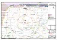
Figure 1: Indicative Wind Farm Development Area
592000 593000 594000 595000 596000 597000<br />
257000<br />
257000<br />
258000<br />
258000<br />
259000<br />
259000<br />
260000<br />
260000<br />
261000<br />
261000<br />
262000<br />
262000<br />
Project:<br />
Proposed Wind Farm at<br />
<strong>Quantans</strong> <strong>Hill</strong>, Dumfries &<br />
Galloway<br />
Title:<br />
Figure 1: Indicative Wind<br />
Farm Development Area<br />
Key<br />
Approximate Scale @ A3: 1:20,000<br />
Based upon Ordnance Survey digital data with the permission of the<br />
¯<br />
Controller of Her Majesty's Stationery Office, © Crown Copyright.<br />
Licence No. AL 100020693.<br />
0 250 500 1,000 m<br />
Date: 15-09-11 Prepared by: DH Checked by: AP<br />
Drawing No: Revisions:<br />
763_M_025<br />
Drawing by:<br />
Site boundary<br />
Additional study area<br />
Notes:<br />
a) Information on this map is directly reproduced from digital and other material<br />
from different sources. Minor discrepancies may therefore occur. Where further<br />
clarification is considered necessary, this is noted through the use of text boxes<br />
on the map itself.<br />
b) For the avoidance of doubt and unless otherwise stated:<br />
1. where a line recorded in the key demarcates a boundary on this plan, the<br />
boundary edge is the outside edge of the line.<br />
2. where a line or feature recorded in the key of this plan is also shown as a<br />
line or feature by the Ordnance Survey, and that line or feature is located<br />
in a different position on the ground than shown by the Ordnance Survey,<br />
then the line or feature shall be deemed to follow the position as existing<br />
on the ground.<br />
3. this plan should be used for identification purposes only, unless specifically<br />
stated above or in accompanying documentation.<br />
Natural Power Consultants Ltd<br />
The Green House<br />
Forrest Estate, Dalry<br />
Castle Douglas, DG7 3XS, <strong>UK</strong><br />
Tel: 01644 430008<br />
Fax: 01644 430009<br />
Email: post@naturalpower.com<br />
www.naturalpower.com
Figure 2: Regional Context Map<br />
Page 22 of 22<br />
<strong>Quantans</strong> <strong>Hill</strong> Wind Farm
} }<br />
} } } } } } } }<br />
} }<br />
} } } } } } } } } } } }<br />
580000 600000<br />
} } }<br />
} } }<br />
} }<br />
} } } }<br />
240000<br />
} } }<br />
} } } } } } } } } }<br />
240000<br />
} } } } } } } } } } } }<br />
} } } } } } } } } }<br />
} } } } } }<br />
} } } } }<br />
} } } } } } } }} }<br />
}<br />
} } } } } } } }<br />
} } } }<br />
} } } }<br />
} } } } } } } } } } } }<br />
} } } }<br />
} } } } } } } }<br />
} } } }<br />
} } } } } } } }<br />
EAST AYRSHIRE<br />
} }<br />
} } } } } }<br />
} } } } } } } }<br />
} } } }<br />
} }<br />
} } } } } } } }<br />
} } } } } } } }<br />
} } } } } } }<br />
260000<br />
}<br />
} } } } } } } } } } } } } } } } } } } } } } } } } } } } } } } } } }<br />
} }<br />
} } } }<br />
} } } } }} }} } }<br />
} } } } } } } } } }<br />
} } } } } } } } } } } } } } }<br />
} } } } } } } } } } } } } } }<br />
} } } } } }<br />
} }<br />
}} }} } }<br />
} }<br />
} } } } } } } } } }<br />
260000<br />
} } } }<br />
} } } } }<br />
} } } } } } }<br />
} } } } } } } } } }<br />
} }<br />
} }<br />
} } } } } }<br />
}<br />
} } }<br />
} }<br />
} }<br />
280000<br />
DRAFT <strong>ON</strong>LY<br />
280000<br />
Project:<br />
Proposed Wind Farm at<br />
<strong>Quantans</strong> <strong>Hill</strong>, Dumfries<br />
& Galloway<br />
Title:<br />
Figure 2: Regional Context<br />
Key Indicative site boundary<br />
Approximate Scale @ A3: 1:150,000<br />
Based upon Ordnance Survey digital data with the permission of the<br />
¯<br />
Controller of Her Majesty's Stationery Office, © Crown Copyright.<br />
Licence No. AL 100020693.<br />
0 1,250 2,500 5,000 m<br />
Date: 12-10-11<br />
Prepared by: IW Checked by: LC<br />
Drawing No: Revisions:<br />
763_M_026<br />
Drawing by:<br />
Regional boundary<br />
Micropaths<br />
National cycle network (4)<br />
} } 132 kV <strong>UK</strong> grid line<br />
Southern Upland Way<br />
Scheduled Ancient Monuments (2)<br />
Scottish Wildlife Trust reserves (3)<br />
Gardens & Designed Landscapes (1)<br />
Special Areas of Conservation (1)<br />
Special Protection Areas (1)<br />
Regional Scenic Areas (2)<br />
Sensitive Landscape Area (4)<br />
RAMSAR (1)<br />
Geological Conservation Review site (1)<br />
National Scenic Area (NSA) (2)<br />
National Nature Reserve (1)<br />
Semi-natural Ancient Woodlands Inventory (1)<br />
Ancient Woodlands Inventory (1)<br />
Site of Special Scientific Interest (1)<br />
Source data reproduced with the permission of:<br />
(1) Scottish Natural Heritage<br />
(2) Historic Scotland<br />
(3) Scottish Wildlife Trust<br />
(4) Sustrans<br />
Notes:<br />
a) Information on this map is directly reproduced from digital and other material<br />
from different sources. Minor discrepancies may therefore occur. Where further<br />
clarification is considered necessary, this is noted through the use of text boxes<br />
on the map itself.<br />
b) For the avoidance of doubt and unless otherwise stated:<br />
1. where a line recorded in the key demarcates a boundary on this plan, the<br />
boundary edge is the outside edge of the line.<br />
2. where a line or feature recorded in the key of this plan is also shown as a<br />
line or feature by the Ordnance Survey, and that line or feature is located<br />
in a different position on the ground than shown by the Ordnance Survey,<br />
then the line or feature shall be deemed to follow the position as existing<br />
on the ground.<br />
3. this plan should be used for identification purposes only, unless specifically<br />
stated above or in accompanying documentation.<br />
Natural Power Consultants Ltd<br />
The Green House<br />
Forrest Estate, Dalry<br />
Castle Douglas, DG7 3XS, <strong>UK</strong><br />
Tel: 01644 430008<br />
Fax: 01644 430009<br />
Email: post@naturalpower.com<br />
www.naturalpower.com<br />
} } } } } } } } } } } } } } } } } } } } } } } } } } } } } } } } } } } } } }<br />
} }<br />
} } } } } } } } } } } } }<br />
} } } } } } } } }<br />
} } } }<br />
} } } } } } } }<br />
} } } } } } } }<br />
} } } } } } } }<br />
} }
E.<strong>ON</strong> Climate & Renewables <strong>UK</strong> Limited<br />
Westwood Way<br />
Westwood Business Park<br />
Coventry<br />
CV4 8LG<br />
T +44 (0) 2476 424000<br />
eon-uk.com/renewables<br />
Registered in England and Wales No. 3758407<br />
Printed on chlorine free paper, which has been manufactured using materials grown from sustainable forests.<br />
100 percent post-consumer waste paper.