- Page 1 and 2: MN SHOVEL READY CERTIFIED DEVELOPME
- Page 3 and 4: MN SHOVEL READY CERTIFIED DEVELOPME
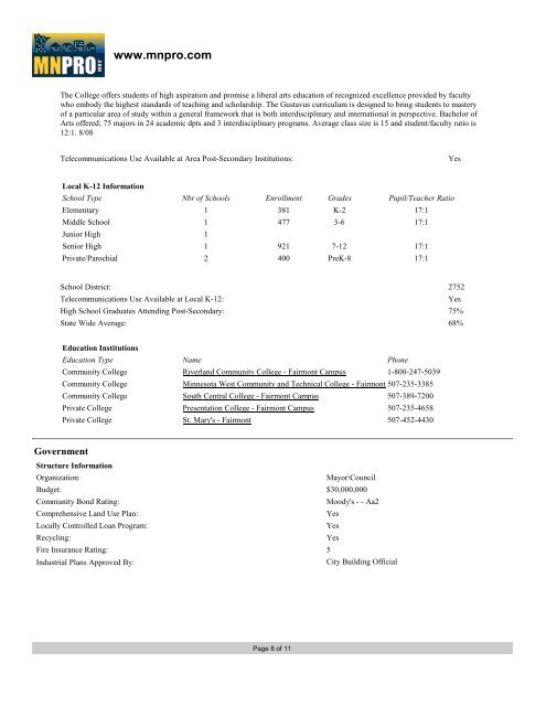
- Page 5 and 6: www.mnpro.com Community Profile for
- Page 7 and 8: www.mnpro.com Healthcare Practition
- Page 9 and 10: www.mnpro.com Navigational Aids BEA
- Page 11: www.mnpro.com Recreation Informatio
- Page 15: www.mnpro.com Addition 1.1 Acres CO
- Page 58 and 59: TABLE OF CONTENTS 1. SUMMARY ......
- Page 60 and 61: 2.5 Special Terms and Conditions Th
- Page 62 and 63:
4.5 Valuation Reduction for Environ
- Page 64 and 65:
eport is included in Appendix G. 5.
- Page 66 and 67:
The surrounding land use is an indu
- Page 69 and 70:
15. QUALIFICATIONS OF ENVIRONMENTAL
- Page 73 and 74:
APPENDIX B EDR RADIUS REPORT
- Page 75 and 76:
SECTION PAGE Executive Summary ES1
- Page 77 and 78:
EXECUTIVE SUMMARY Proposed NPL Prop
- Page 79 and 80:
EXECUTIVE SUMMARY DOD Department of
- Page 81 and 82:
EXECUTIVE SUMMARY Due to poor or in
- Page 83 and 84:
2 0 0 1 200 EDR Inc. 1200
- Page 85 and 86:
MAP FINDINGS SUMMARY Search Target
- Page 87 and 88:
Map ID Direction Distance Elevation
- Page 89 and 90:
Map ID Direction Distance Elevation
- Page 91 and 92:
Map ID Direction Distance Elevation
- Page 93 and 94:
Map ID Direction Distance Elevation
- Page 95 and 96:
Map ID Direction Distance Elevation
- Page 97 and 98:
Map ID Direction Distance Elevation
- Page 99 and 100:
Map ID Direction Distance Elevation
- Page 101 and 102:
Map ID Direction Distance Elevation
- Page 103 and 104:
Map ID Direction Distance Elevation
- Page 105 and 106:
Map ID Direction Distance Elevation
- Page 107 and 108:
Map ID Direction Distance Elevation
- Page 109 and 110:
Map ID Direction Distance Elevation
- Page 111 and 112:
Map ID Direction Distance Elevation
- Page 113 and 114:
Map ID Direction Distance Elevation
- Page 115 and 116:
Map ID Direction Distance Elevation
- Page 117 and 118:
Map ID Direction Distance Elevation
- Page 119 and 120:
Map ID Direction Distance Elevation
- Page 121 and 122:
Map ID Direction Distance Elevation
- Page 123 and 124:
Map ID Direction Distance Elevation
- Page 125 and 126:
Map ID Direction Distance Elevation
- Page 127 and 128:
Map ID Direction Distance Elevation
- Page 129 and 130:
GOVERNMENT RECORDS SEARCHED / DATA
- Page 131 and 132:
GOVERNMENT RECORDS SEARCHED / DATA
- Page 133 and 134:
GOVERNMENT RECORDS SEARCHED / DATA
- Page 135 and 136:
GOVERNMENT RECORDS SEARCHED / DATA
- Page 137 and 138:
GOVERNMENT RECORDS SEARCHED / DATA
- Page 139 and 140:
GOVERNMENT RECORDS SEARCHED / DATA
- Page 141 and 142:
GOVERNMENT RECORDS SEARCHED / DATA
- Page 143 and 144:
GOVERNMENT RECORDS SEARCHED / DATA
- Page 145 and 146:
GOVERNMENT RECORDS SEARCHED / DATA
- Page 147 and 148:
GOVERNMENT RECORDS SEARCHED / DATA
- Page 149 and 150:
GOVERNMENT RECORDS SEARCHED / DATA
- Page 151 and 152:
TARGET PROPERTY TOPOGRAPHY General
- Page 153 and 154:
GEOCHECK ® - PHYSICAL SETTING SOUR
- Page 155 and 156:
Soil Map ID: 1 Soil Component Name:
- Page 157 and 158:
Hydric Status: Not hydric Corrosion
- Page 159 and 160:
1 2 Soil Map ID: 6 1 0 inches 9 inc
- Page 161 and 162:
2 3 Soil Map ID: 8 1 18 inches 33 i
- Page 163 and 164:
2 3 LOCAL / REGIONAL WATER AGENCY R
- Page 165 and 166:
EDR Inc. 1 2 4 0 1 2 4 0 4 0 1 2 4
- Page 167 and 168:
Address Information: Relateid: Addt
- Page 169 and 170:
Well label: Swldate: Swlavgmeas: Sw
- Page 171 and 172:
Updt date: Geoc type: Geoc src: Utm
- Page 173 and 174:
Updt date: Geoc type: Geoc src: Utm
- Page 175 and 176:
Updt date: Geoc type: Geoc src: Utm
- Page 177 and 178:
Well label: Swldate: Swlavgmeas: Sw
- Page 179 and 180:
Well label: Swldate: Swlavgmeas: Sw
- Page 181 and 182:
Screen mfg: Ptlss mfg: Bsmt offst:
- Page 183 and 184:
PHYSICAL SETTING SOURCE RECORDS SEA
- Page 185 and 186:
PHYSICAL SETTING SOURCE RECORDS SEA
- Page 187 and 188:
BOLTON & MENK, INC. SITE INSPECTION
- Page 189 and 190:
BRIEFLY DESCRIBE THE OPERATIONS CON
- Page 191 and 192:
From the north end of Timberlake Ro
- Page 193 and 194:
On Timberlake Road, looking southea
- Page 195 and 196:
On Timberlake Road, looking north-n
- Page 197 and 198:
On CSAH 26, looking north-northwest
- Page 199 and 200:
On CSAH 26, looking north-northeast
- Page 201 and 202:
In northeast corner of Kahler Autom
- Page 203 and 204:
APPENDIX D HISTORICAL AERIAL PHOTOS
- Page 205 and 206:
EDR Aerial Photo Decade Package Env
- Page 207 and 208:
INQUIRY #: YEAR: 1938 2700885.5 = 5
- Page 209 and 210:
INQUIRY #: YEAR: 1954 2700885.5 = 5
- Page 211 and 212:
INQUIRY #: YEAR: 1968 2700885.5 = 5
- Page 213 and 214:
INQUIRY #: YEAR: 1996 2700885.5 = 5
- Page 215 and 216:
INQUIRY #: YEAR: 2006 2700885.5 = 6
- Page 217 and 218:
Fairmont Industrial Park 828 Timber
- Page 219 and 220:
N → TARGET QUAD NAME: WELCOME MAP
- Page 221 and 222:
Fairmont Industrial Park 828 Timber
- Page 223 and 224:
Fairmont Industrial Park 828 Timber
- Page 225 and 226:
Fairmont Industrial Park 828 Timber
- Page 227 and 228:
2009 Enhancements to EDR City Direc
- Page 229 and 230:
SELECTED ADDRESSES EXECUTIVE SUMMAR
- Page 231 and 232:
ADJOINING PROPERTY DETAIL FINDINGS
- Page 233 and 234:
APPENDIX G EDR ENVIRONMENTAL LIEN S
- Page 235 and 236:
DEEDS TRACT NO. 1 1 Grantee(s): Fai
- Page 237 and 238:
NCO Financial Systems, Inc. Financi
- Page 239 and 240:
2 Grantee(s): Fairmont Growth Oppor
- Page 241 and 242:
TRACT NO. 5 1 Grantee(s): Fairmont
- Page 243 and 244:
2 Grantee(s): Harold J. Armstrong (
- Page 245 and 246:
3 Grantee(s): Harold J. Armstrong (
- Page 247:
NCO Financial Systems, Inc. Financi
- Page 276 and 277:
I. General Information/Site History
- Page 278 and 279:
3) Have you attempted to identify,
- Page 280 and 281:
3) Does this facility/site discharg
- Page 282 and 283:
4) Briefly describe procedures used
- Page 284:
3) Briefly describe how and where t
- Page 333:
CONTAMINANT (UNITS) REGULATED CONTA
- Page 336 and 337:
uncontrolled storm water runoff and
- Page 338 and 339:
or equivalent permanent stabilizati
- Page 340 and 341:
"Stabilized" means the exposed grou
- Page 342 and 343:
ecent version of the Minnesota Poll
- Page 344 and 345:
j. Steep slopes and bluffs requirem
- Page 346 and 347:
Permit (NPDES) requirements. Under
- Page 348 and 349:
g. Disconnect impervious areas by a
- Page 350 and 351:
Fairmont City Code or Minnesota Sta
- Page 352 and 353:
case-by-case basis. The content of
- Page 354 and 355:
compliance with this ordinance, aft