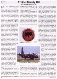
Project Muddy Hill - Thai Aviation History
Project Muddy Hill - Thai Aviation History
Project Muddy Hill - Thai Aviation History

Create successful ePaper yourself
Turn your PDF publications into a flip-book with our unique Google optimized e-Paper software.
The <strong>Muddy</strong> <strong>Hill</strong> aircraft, with an aircrew of six, departed NATC in late July 1967,<br />
followed by twenty seven military, civilian contractor and civil service project<br />
personnel and support equipment via an USAF MAC C-141 aircraft for Udorn Thani,<br />
Royal <strong>Thai</strong> Air Force Base (Udorn RTAFB). Udorn RTAFB was located in the<br />
northeastern sector of <strong>Thai</strong>land, just south of the Mekong River forming the<br />
<strong>Thai</strong>land-Laos border. The Air America compound at Udorn RTAFB was the<br />
project’s staging area for the next four months.<br />
Aircraft avionics systems test and road reconnaissance crewmember training flights<br />
were conducted around the Udorn area. Combat environment, aerial<br />
reconnaissance missions were conducted during both daytime and nighttime hours<br />
in the ‘Barrel Roll’ and ‘Tiger Hound’ areas of Laos. Military operational missions<br />
were fully briefed with intelligence, defensive threat scenarios, and conjunctive<br />
military flight operations in the mission areas. Target areas consisted of the Ho Chi<br />
Minh Trail and its road segments as well as other locations in the Plaine des Jarres<br />
in central Laos. Flight durations averaged 4-5 hours with takeoffs around 0500 and<br />
1900 hours. While at Udorn RTAFB, the pilot and co-pilot’s seats were reinforced<br />
with seat armor salvaged from crashed Army helicopters.<br />
Mission flight parameters varied between 200 and 1500 feet absolute altitude on<br />
terrain following radar in the rugged, mountainous terrain of Laos. Primary target<br />
area guidance was accomplished by the author’s usage of a hand-held starlight<br />
(night vision) scope in the aircraft’s Plexiglas bow observer station. The author used<br />
the night vision scope imagery to locate road segments, navigation waypoints and<br />
individual targets. Voice commands via the aircraft’s inter-communication system<br />
were used to direct the plane commander to target locations. Usage of the night<br />
vision scope by the author also provided terrain avoidance to complement terrain<br />
following radar electronic commands. Suspected targets of interest were marked<br />
airborne flare parachutes that had been impregnated with green, chemiluminescent