The Terraced landscapes of The MalTese Islands - Landscape Europe
The Terraced landscapes of The MalTese Islands - Landscape Europe
The Terraced landscapes of The MalTese Islands - Landscape Europe

You also want an ePaper? Increase the reach of your titles
YUMPU automatically turns print PDFs into web optimized ePapers that Google loves.
0 | Chapter 24: Rolé<br />
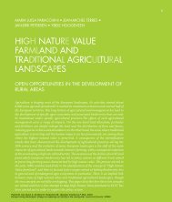
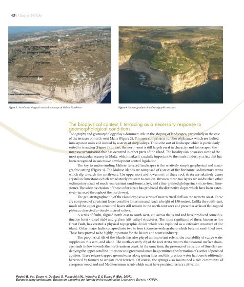
Figure 3. Aerial view <strong>of</strong> typical terraced landscape <strong>of</strong> Maltese Northwest Figure 4. Maltese geophysical and stratigraphic structure<br />
<strong>The</strong> biophysical context I: terracing as a necessary response to<br />
geomorphological conditions<br />
Topography and geomorphology play a dominant role in the shaping <strong>of</strong> <strong>landscapes</strong>, particularly in the case<br />
<strong>of</strong> the terraces <strong>of</strong> north-west Malta (Figure 2). This area comprises a number <strong>of</strong> plateaux which are faulted<br />
into separate units and incised by a series <strong>of</strong> deep valleys. This is the sort <strong>of</strong> landscape which is particularly<br />
suited to terracing (Figure 3). In fact, the north-west is still largely rural in character and has escaped the<br />
intensive urbanisation that has occurred in other parts <strong>of</strong> the island. <strong>The</strong> locality also possesses some <strong>of</strong> the<br />
most spectacular scenery in Malta, which makes it crucially important to the tourist industry: a fact that has<br />
been recognised in successive development control legislation.<br />
<strong>The</strong> key to understanding Maltese terraced <strong>landscapes</strong> is the relatively simple geophysical and stratigraphic<br />
setting (Figure 4). <strong>The</strong> Maltese islands are composed <strong>of</strong> a series <strong>of</strong> five horizontal sedimentary strata<br />
which dip towards the north-east. <strong>The</strong> uppermost and lowermost <strong>of</strong> these rock strata are relatively dense<br />
crystalline limestones which are relatively resistant to erosion. Between these two layers are sandwiched other<br />
sedimentary strata <strong>of</strong> much less resistant sandstones, clays, and a fine-grained globigerina (micro-fossil limestone).<br />
<strong>The</strong> selective erosion <strong>of</strong> these s<strong>of</strong>ter strata has produced the distinctive slopes which have been extensively<br />
terraced throughout the north-west.<br />
<strong>The</strong> geo-stratigraphic tilt <strong>of</strong> the island exposes a series <strong>of</strong> near-vertical cliffs on the western coast. <strong>The</strong>se<br />
are composed <strong>of</strong> a resistant lower coralline limestone and reach a height <strong>of</strong> 130 metres. Unlike the south-east,<br />
much <strong>of</strong> the upper geo-structural layers still remain in the north-west area and present a series <strong>of</strong> flat-topped<br />
plateaux dissected by deeply incised valleys.<br />
A series <strong>of</strong> faults, aligned north-east to south-west, cut across the island and have produced some distinctive<br />
horst (raised slab) and graben (rift valley) structures. <strong>The</strong> most significant <strong>of</strong> these, known as the<br />
Great Fault, has created a physical topographic divide which was exploited as a defensive structure <strong>of</strong> the<br />
island. Other major faults collapsed into two to four kilometre-wide grabens which became sand-filled bays.<br />
<strong>The</strong>se have proved to be highly important for the leisure and tourist industry.<br />
<strong>The</strong> geophysical tilt <strong>of</strong> the islands has also played an important role in the availability <strong>of</strong> scarce water<br />
supplies on this semi-arid island. <strong>The</strong> north-easterly dip <strong>of</strong> the rock strata ensures that seasonal surface drainage<br />
tends to flow towards the north-eastern coast. At the same time, the presence <strong>of</strong> a stratum <strong>of</strong> blue clay underlying<br />
the upper coralline limestone and greensand strata has permitted the formation <strong>of</strong> a series <strong>of</strong> perched<br />
aquifers. <strong>The</strong>se release trapped groundwater along spring lines and this precious water has been traditionally<br />
harvested by farmers to irrigate their terraces. Of course, the springs also maintained a rich community <strong>of</strong><br />
evergreen woodland and Mediterranean scrub which must have predated terrace cultivation.<br />
Pedroli B, Van Doorn A, De Blust G, Paracchini ML, Wascher D & Bunce F (Eds. 2007).<br />
<strong>Europe</strong>’s living <strong>landscapes</strong>. Essays on exploring our identity in the countryside. LANDSCAPE EUROPE / KNNV.