

SourCeBook oN remoTe SeNSiNg aND BioDiverSiTy iNDiCaTorS
SourCeBook oN remoTe SeNSiNg aND BioDiverSiTy iNDiCaTorS
SourCeBook oN remoTe SeNSiNg aND BioDiverSiTy iNDiCaTorS

You also want an ePaper? Increase the reach of your titles
YUMPU automatically turns print PDFs into web optimized ePapers that Google loves.
Chapter 4. Trends in Selected Biomes, Habitats, and Ecosystems: Forests<br />
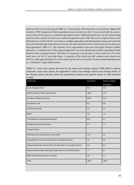
ested over the 1 year time period (Table 4.1). The majority of the forest loss occurred near villages that<br />
existed in 1990. Expansion of these populated areas occurred over the 1 year period with the conversion<br />
of most of the forest to residential-agricultural lands. Additional forest loss was also found along<br />
road networks, several of which were created or improved since 1990. The semi-evergreen forests were<br />
deforested as a result of both conversion to swidden agriculture and deforestation along road networks<br />
that were built through these blocks of forests. We also found that 0.6% of the forests in the study area<br />
had regenerated (Table 4.1). The majority of the regeneration areas were from prior intensive timber<br />
operations. A small portion of the regenerating forest was from abandoned swidden agricultural lands<br />
found in semi-evergreen forests. Therefore we measured a net decrease in forest areas of .3% in the<br />
study area over the 1 year time frame. A majority of the study area still contains native land cover<br />
(89.1%), while approximately 9% of the study area has been converted to human-dominated land uses<br />
(i.e. residential or agricultural lands).<br />
TABle 4.1. land cover classes and area for the land cover change analysis (1990-2002) in eastern<br />
Cambodia. land cover classes are separated in static (non-change) classes and change classes. In<br />
the change classes, the text within the parenthesis indicates the general classes in 1990 and then<br />
in 2002.<br />
land Cover Area (km2) Percent of region<br />
Semi-evergreen forest 94.4<br />
of analysis<br />
12.0<br />
Mixed deciduous forest (semi-dense) 186.3 23.7<br />
Deciduous dipterocarp forest 409.5 52.2<br />
grasslands-scrub 6.3 0.8<br />
Seasonal wetlands 3.4 0.4<br />
Water 7.6 1.0<br />
Seasonally bare land/Agricultural land 40.3 5.1<br />
Residential-agricultural mosaic 9.2 1.2<br />
Change Classes<br />
Deforested area (intact forest to bare land) 15.5 2.0<br />
Degraded forest mosaic (intact forests to disturbed forests) 7.0 0.9<br />
Regenerating forest mosaic (bare soil-agriculture to secondary forests) 3.8 0.5<br />
Regenerating swidden agriculture (agriculture to secondary forests) 1.1 0.1<br />
Water expansion (agriculture to water) 0.8 0.1<br />
Total 785.3 100.0<br />
43