CN LINES V12N3 - Canadian National Railways Historical Association
CN LINES V12N3 - Canadian National Railways Historical Association
CN LINES V12N3 - Canadian National Railways Historical Association

Create successful ePaper yourself
Turn your PDF publications into a flip-book with our unique Google optimized e-Paper software.
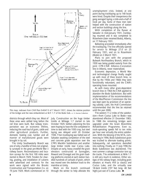
This map, redrawn from <strong>CN</strong>R Plan E-4047-3 of 7 March 1957, shows the relative position<br />
of the bridge and the new embankment at M.P. 1.7 of the Bodo Sub.—L. S. Kozma Collection<br />
districts through which they ran. Most of<br />
these areas were settled long before the<br />
rail lines were built. But railway transportation<br />
was an economic lifeline,<br />
reducing the road haul of grain, cattle and<br />
other agricultural products. Further,<br />
domestic heating coal, lumber and all<br />
manner of manufactured goods were<br />
brought in by rail.<br />
The Unity Southwesterly Branch was<br />
one of only a handful of lines not originally<br />
surveyed in the great pre-World War I<br />
railway boom. Reconnaissance and location<br />
surveys for the first 100 miles were<br />
started in March 1929. Tenders for clearing,<br />
grading, and installation of culverts<br />
were advertised and contracts for the<br />
work were signed with the Brooks<br />
Construction and Transportation Co. on<br />
19 June 1929. Work commenced on 10<br />
July. Construction on the huge timber<br />
trestle at Mileage 1.7 started in late<br />
October 1929. Settlers adjoining the line<br />
were hoping to have the line completed in<br />
time to deal with the 1930 crop, but steel<br />
laying was delayed until 20 October<br />
1930. Then tracklaying was halted east of<br />
Salvador awaiting completion of the steel<br />
and concrete grade separation over the<br />
CPR’s Macklin Subdivision and another<br />
large timber trestle near Cactus Lake.<br />
Despite an early, heavy snowfall the grain<br />
elevators constructed at Sunnyglen,<br />
Reward and Donegal and the grain loading<br />
platforms erected at each station handled<br />
hundreds of carloads of grain, which<br />
was moved over the skeleton track to the<br />
mainline at Unity.<br />
Work on the branch continued<br />
through the winter to help alleviate the<br />
unemployment crisis. Indeed, at one<br />
point during tracklaying up to 140 locals<br />
were hired. Despite their inexperience the<br />
gang averaged laying a mile-and-a-half of<br />
track per day. Some of these men later<br />
helped with the construction of station<br />
and section buildings along the line.<br />
With completion of the flyover at<br />
Salvador in mid-January 1931, tracklaying<br />
resumed and it was completed to<br />
Rosenheim (later renamed Bodo), Alberta,<br />
on 17 February 1931.<br />
Ballasting proceeded immediately after<br />
the tracklaying. The line officially opened<br />
for service to Mileage 27.0 on 25<br />
February 1931, and on to Rosenheim<br />
(Bodo) on 3 March 1931.<br />
Plans to join with the proposed<br />
Bulwark Northeastlery Branch, which in<br />
1930 was being graded easterly from the<br />
joint CPR-<strong>CN</strong>R Alliance–Coronation<br />
line in Alberta, never materialized.<br />
Economic depression, a World War<br />
and technological change finally caught<br />
up with most of these branch lines, so<br />
that by the 1950s and 1960s they were<br />
functionally redundant, and the <strong>CN</strong>R’s<br />
operating losses mounted.<br />
As with many other grain-dependent<br />
branch lines in 1964 the <strong>CN</strong>R applied to<br />
abandon the Bodo Subdivision. But with<br />
implementation of the recommendations<br />
of the MacPherson Commission the line<br />
was kept open by provision of an operating<br />
subsidy. Later, the Hall Commission<br />
recommended that the line be retained<br />
until the year 2000.<br />
The western 11.2 miles of the subdivision—from<br />
Cactus Lake to Bodo—was<br />
abandoned effective 31 December 1983.<br />
In 1988 the remaining bridges were<br />
upgraded under the Grain Branchline<br />
Rehabilitation Programme. Even so,<br />
track-operating speeds fell to ten miles<br />
per hour over virtually the entire subdivision.<br />
With the blessing of the NTA, commencing<br />
in 1994, Bodo Subdivision grain<br />
was trucked to alternate loading points.<br />
Subsequently, rail operations dwindled<br />
into nothing. Finally, on 11 July 1996 the<br />
Bodo Subdivision was abandoned. The<br />
next summer a salvage contractor tore up<br />
the tracks. The embankment at Mile 1.7<br />
is still very much in evidence. Other vestiges<br />
of the railway linger, including grain<br />
elevators at Hearts Hill (a classic) and<br />
Cactus Lake, and the virtually new<br />
18-bent trestle (197 feet long, 40 feet<br />
high) just east of Cactus Lake.<br />
8 <strong>CN</strong> <strong>LINES</strong>