Five Intertidal Areas of the Persian Gulf
Five Intertidal Areas of the Persian Gulf
Five Intertidal Areas of the Persian Gulf

Create successful ePaper yourself
Turn your PDF publications into a flip-book with our unique Google optimized e-Paper software.
30<br />
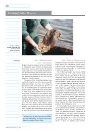
<strong>Intertidal</strong> <strong>Areas</strong> <strong>of</strong> <strong>the</strong> <strong>Persian</strong> <strong>Gulf</strong><br />
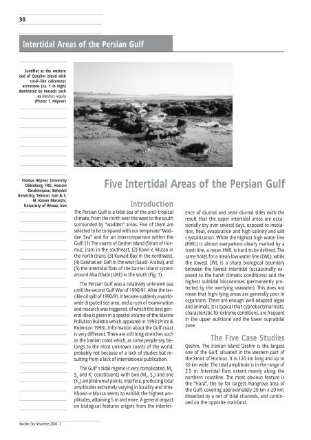
Sandflat at <strong>the</strong> western<br />
end <strong>of</strong> Queshm island with<br />
coral-like calcereous<br />
accretions (ca. 1 m high)<br />
dominated by mussels such<br />
as Melleus regula<br />
(Photo: T. Höpner)<br />
Thomas Höpner, University<br />
Oldenburg, FRG, Hossein<br />
Ebrahimipour, Beheshti<br />
University, Teheran, Iran & S.<br />
M. Kazem Maraschi,<br />
University <strong>of</strong> Ahwaz, Iran<br />
Wadden Sea Newsletter 2000 - 2<br />
<strong>Five</strong> <strong>Intertidal</strong> <strong>Areas</strong> <strong>of</strong> <strong>the</strong> <strong>Persian</strong> <strong>Gulf</strong><br />
Introduction<br />
The <strong>Persian</strong> <strong>Gulf</strong> is a tidal sea <strong>of</strong> <strong>the</strong> arid-tropical<br />
climate, from <strong>the</strong> north over <strong>the</strong> west to <strong>the</strong> south<br />
surrounded by “wadden” areas. <strong>Five</strong> <strong>of</strong> <strong>the</strong>m are<br />
selected to be compared with our temperate “Wadden<br />
Sea” and for an intercomparison within <strong>the</strong><br />
<strong>Gulf</strong>: (1) The coasts <strong>of</strong> Qeshm island (Strait <strong>of</strong> Hormuz,<br />
Iran) in <strong>the</strong> sou<strong>the</strong>ast, (2) Kowr-e Mussa in<br />
<strong>the</strong> north (Iran). (3) Kuwait Bay in <strong>the</strong> northwest,<br />
(4) Dawhat ad-Dafi in <strong>the</strong> west (Saudi-Arabia), and<br />
(5) <strong>the</strong> intertidal flats <strong>of</strong> <strong>the</strong> barrier island system<br />
around Abu Dhabi (UAE) in <strong>the</strong> south (Fig. 1).<br />
The <strong>Persian</strong> <strong>Gulf</strong> was a relatively unknown sea<br />
until <strong>the</strong> second <strong>Gulf</strong> War <strong>of</strong> 1990/91. After <strong>the</strong> terrible<br />
oil spill <strong>of</strong> 1990/91, it became suddenly a worldwide<br />
disputed sea area, and a rush <strong>of</strong> examination<br />
and research was triggered, <strong>of</strong> which <strong>the</strong> best general<br />
idea is given in a special volume <strong>of</strong> <strong>the</strong> Marine<br />
Pollution Bulletin which appeared in 1993 (Price &<br />
Robinson 1993). Information about <strong>the</strong> <strong>Gulf</strong> coast<br />
is very different. There are still long stretches such<br />
as <strong>the</strong> Iranian coast which, as some people say, belongs<br />
to <strong>the</strong> most unknown coasts <strong>of</strong> <strong>the</strong> world,<br />
probably not because <strong>of</strong> a lack <strong>of</strong> studies but resulting<br />
from a lack <strong>of</strong> international publication.<br />
The <strong>Gulf</strong>´s tidal regime is very complicated. M , 2<br />
S and K constituents with two (M , S ) and one<br />
2 1 2 2<br />
(K ) amphidromal points interfere, producing tidal<br />
2<br />
amplitudes extremely varying in locality and time.<br />
Khowr-e Mussa seems to exhibit <strong>the</strong> highest amplitudes,<br />
attaining 5 m and more. A general impact<br />
on biological features origins from <strong>the</strong> interfer-<br />
ence <strong>of</strong> diurnal and semi-diurnal tides with <strong>the</strong><br />
result that <strong>the</strong> upper intertidal areas are occasionally<br />
dry over several days, exposed to insolation,<br />
heat, evaporation and high salinity and salt<br />
crystallization. While <strong>the</strong> highest high water line<br />
(HWL) is almost everywhere clearly marked by a<br />
trash line, a mean HWL is hard to be defined. The<br />
same holds for a mean low water line (LWL), while<br />
<strong>the</strong> lowest LWL is a sharp biological boundary<br />
between <strong>the</strong> lowest intertidal (occasionally exposed<br />
to <strong>the</strong> harsh climatic conditions) and <strong>the</strong><br />
highest subtidal biocoenoses (permanently protected<br />
by <strong>the</strong> overlying seawater). This does not<br />
mean that high-lying areas are generally poor in<br />
organisms. There are enough well adapted algae<br />
and animals. It is typical that cyanobacterial mats,<br />
characteristic for extreme conditions, are frequent<br />
in <strong>the</strong> upper eulittoral and <strong>the</strong> lower supratidal<br />
zone.<br />
The <strong>Five</strong> Case Studies<br />
Qeshm. The Iranian island Qeshm is <strong>the</strong> largest<br />
one <strong>of</strong> <strong>the</strong> <strong>Gulf</strong>, situated in <strong>the</strong> western part <strong>of</strong><br />
<strong>the</strong> Strait <strong>of</strong> Hormuz. It is 120 km long and up to<br />
30 km wide. The tidal amplitude is in <strong>the</strong> range <strong>of</strong><br />
2.5 m. <strong>Intertidal</strong> flats extent mainly along <strong>the</strong><br />
nor<strong>the</strong>rn coastline. The most obvious feature is<br />
<strong>the</strong> “Hara”, <strong>the</strong> by far largest mangrove area <strong>of</strong><br />
<strong>the</strong> <strong>Gulf</strong>, covering approximately 20 km x 20 km,<br />
dissected by a net <strong>of</strong> tidal channels, and continued<br />
on <strong>the</strong> opposite mainland.
Qeshm has many different intertidal zones,<br />
sandy, mixed, and muddy, and in <strong>the</strong> south also<br />
rocky. Many sandy flats are found along <strong>the</strong> sou<strong>the</strong>rn<br />
shoreline, which is relatively exposed. <strong>Intertidal</strong><br />
flats attain a width <strong>of</strong> two kilometers and more in<br />
<strong>the</strong> west and north and exhibit incredible numbers<br />
<strong>of</strong> macrobenthic individuals on <strong>the</strong> surface, mainly<br />
mudskippers and large crabs. The lower supratidal<br />
zone around Hara is covered by cyanobacterial mats.<br />
Queshm seems to be a ga<strong>the</strong>ring area for migrating<br />
birds before <strong>the</strong>y go back to <strong>the</strong> North. “Hara<br />
Protected Area”, now a Biosphere Reserve (860 km2 )<br />
<strong>of</strong> <strong>the</strong> IUCN Management Category IV and IX, has<br />
this status since 1980 after o<strong>the</strong>r protection categories<br />
since 1970. Use is restricted to fishery (mainly<br />
shrimps), occasional boat trips and some mangrove<br />
cutting (for feeding <strong>the</strong> cattle).<br />
Khowr-e Mussa. The area has been preliminarily<br />
described in this journal by Höpner & Maraschi<br />
(1999). It consists <strong>of</strong> a basin approximately<br />
<strong>the</strong> size <strong>of</strong> <strong>the</strong> Jadebusen or <strong>the</strong> Dollard, surrounded<br />
by a corona <strong>of</strong> numerous tidal creeks <strong>of</strong> varying<br />
length and width, and <strong>the</strong> link to <strong>the</strong> <strong>Gulf</strong> by a<br />
50 km long estuary-like channel.<br />
Bay <strong>of</strong> Kuwait. The bay is about 30 km wide<br />
and about 45 km long. The mean tidal amplitude<br />
is in <strong>the</strong> range <strong>of</strong> 2 m and about two thirds <strong>of</strong> <strong>the</strong><br />
bay are dry during low water. <strong>Intertidal</strong> flats <strong>of</strong> a<br />
width <strong>of</strong> up to several km stretch mainly along<br />
<strong>the</strong> nor<strong>the</strong>rn coast. The muddy character is extreme,<br />
and <strong>the</strong>re are mudflats in <strong>the</strong> inner part,<br />
which are virtually inaccessible for a walker. The<br />
bay seems to serve as a trap for finest sediments<br />
from <strong>the</strong> Shatt al Arab.<br />
Mussallamiyah-Dafi Area . Approximately in<br />
1998, <strong>the</strong> area was selected by <strong>the</strong> Saudi Arabian<br />
National Commission for Wildlife Conservation<br />
and Development (NCWCD) with <strong>the</strong> support <strong>of</strong><br />
European Scientists and <strong>the</strong> European Union to<br />
start an international joint ecological research<br />
project with <strong>the</strong> objective to establish a Marine<br />
Wildlife Sanctuary (Krupp & Jones 1993). The research<br />
results, which were published in one final<br />
(Krupp et al. 1996) and three intermediate reports<br />
and at least 127 original publications make <strong>the</strong><br />
area <strong>the</strong> best described coastal ecosystem <strong>of</strong> <strong>the</strong><br />
whole <strong>Gulf</strong>. The outstanding property is <strong>the</strong> unique<br />
concentration <strong>of</strong> nearly all habitat types <strong>of</strong> <strong>the</strong><br />
western <strong>Gulf</strong> within a delimited area. On land,<br />
habitats <strong>of</strong> size and importance are sea-influenced<br />
sabkhas, dunes, salt marshes and limestone cliffs.<br />
In <strong>the</strong> intertidal zone, cyanobacterial mats, crab<br />
colonies, beachrock flats, mud and sand flats and<br />
some mangrove spots are represented, and <strong>the</strong>se<br />
Kuwait<br />
100 km<br />
48°<br />
Musallamiyah<br />
Dafi<br />
Busheer<br />
Manifah Manifa<br />
Bay<br />
50°<br />
Khowr-e Mussa<br />
Salwah<br />
Bay<br />
Tarut<br />
in many variations. In <strong>the</strong> subtidal zone, macroalgal<br />
beds, seagrass meadows, coral reefs and mobile<br />
sand bottoms are typical.<br />
Abu Dhabi Barrier Island System. This is clearly<br />
<strong>the</strong> intertidal area <strong>of</strong> <strong>the</strong> highest similarity to <strong>the</strong><br />
central Wadden Sea <strong>of</strong> <strong>the</strong> sou<strong>the</strong>rn North Sea.<br />
There are seven barrier islands lined one after <strong>the</strong><br />
o<strong>the</strong>r in west-east direction. The “Wadden Sea”<br />
behind <strong>the</strong>m has approximately <strong>the</strong> same size as<br />
ours, but it is dissected by broad tails <strong>of</strong> <strong>the</strong> islands<br />
(so-called tomboli). The tidal amplitude is<br />
between one and two meters, and at low water<br />
most <strong>of</strong> <strong>the</strong> “Wadden Sea” is exposed. The intertidal<br />
system can be understood by regarding four<br />
aspects, two <strong>of</strong> which are morphological/geological<br />
and two are ecological/biological: <strong>the</strong> barrier<br />
islands and <strong>the</strong> transition <strong>of</strong> coastal sabkhas to<br />
<strong>the</strong> intertidal zone is <strong>the</strong> first pair, and <strong>the</strong> cyanobacterial<br />
mats and <strong>the</strong> mangrove areas is <strong>the</strong> second.<br />
Discussion<br />
The sequence chosen here for <strong>the</strong> treatment <strong>of</strong><br />
<strong>the</strong> five intertidal areas follows <strong>the</strong> anticlockwise<br />
main ring-shaped current within <strong>the</strong> <strong>Gulf</strong> by which<br />
Queshm is served with fresh oceanic water while<br />
Abu Dhabi receives water after a mean residence<br />
time <strong>of</strong> about two years in <strong>the</strong> <strong>Gulf</strong>. There are so<br />
far no conclusions about a connection between<br />
age or quality <strong>of</strong> <strong>the</strong> seawater on <strong>the</strong> one hand<br />
and <strong>the</strong> ecological quality <strong>of</strong> <strong>the</strong> sites on <strong>the</strong> o<strong>the</strong>r<br />
hand. As <strong>the</strong> comparative examinations between<br />
<strong>the</strong> Banc d´Arguin and North Sea flats have<br />
shown, <strong>the</strong>re is no fundamental difference in biomass<br />
density between climatically different intertidal<br />
sediments (Ens et al. 1990).<br />
<strong>Intertidal</strong> <strong>Areas</strong> <strong>of</strong> <strong>the</strong> <strong>Persian</strong> <strong>Gulf</strong> 31<br />
P e r s i a n G u l f<br />
<strong>Persian</strong> <strong>Gulf</strong><br />
Qeshm<br />
Strait <strong>of</strong><br />
Hormuz<br />
Strait <strong>of</strong><br />
Hormuz<br />
52° 54° 56°<br />
Abu Dhabi<br />
30°<br />
28°<br />
26°<br />
24°<br />
Figure 1: Location <strong>of</strong> <strong>the</strong><br />
five intertidal areas in <strong>the</strong><br />
<strong>Persian</strong> <strong>Gulf</strong>.<br />
Wadden Sea Newsletter 2000 - 2
32<br />
<strong>Intertidal</strong> <strong>Areas</strong> <strong>of</strong> <strong>the</strong> <strong>Persian</strong> <strong>Gulf</strong><br />
Seaward mangrove<br />
(Avicennia marina) edge west<br />
<strong>of</strong> Abu Dhabi. In <strong>the</strong><br />
foreground piles <strong>of</strong> echiuran<br />
Phrashadus pirotansis<br />
(Photo: T. Höpner).<br />
Wadden Sea Newsletter 2000 - 2<br />
<strong>Intertidal</strong> areas <strong>of</strong> <strong>the</strong> <strong>Gulf</strong> are generally or at<br />
least potentially hypersaline. In <strong>the</strong> Mussallamiyah-Dafi<br />
area, for instance, all salinities between<br />
45 and saturation could be observed. As a<br />
contrast, in <strong>the</strong> intertidal zone <strong>of</strong> Qeshm, salinities<br />
are only around 39 to 42 with single top values<br />
<strong>of</strong> 45 psu, independently <strong>of</strong> tide and season<br />
(Ebrahimipour, unpublished). Hence, intertidal research<br />
in <strong>the</strong> <strong>Gulf</strong> means hypersaline research, but<br />
a reference <strong>of</strong> oceanic salinity is available.<br />
The ecological functions which <strong>the</strong> intertidal<br />
zone has in temperate cases are also found along<br />
<strong>the</strong> coastline <strong>of</strong> <strong>the</strong> <strong>Gulf</strong>: high primary and secondary<br />
productivity, shelter for reproduction and<br />
development <strong>of</strong> juveniles, food source for fishes and<br />
birds, diversity <strong>of</strong> <strong>the</strong> biotopes as a precondition for<br />
<strong>the</strong> diversity <strong>of</strong> <strong>the</strong> biota. To inhabit intertidal flats<br />
<strong>of</strong> <strong>the</strong> harsh climate <strong>of</strong> <strong>the</strong> <strong>Gulf</strong> means still more<br />
adaptation to changing conditions: The temperature<br />
<strong>of</strong> <strong>the</strong> sediment surface may increase under<br />
insolation to 60 0C and more even if <strong>the</strong> sediment<br />
is moist, and salinities may increase until salt crystallizes.<br />
In <strong>the</strong> temperate climate, moving from <strong>the</strong> land<br />
over <strong>the</strong> intertidal zone into <strong>the</strong> subtidal area does<br />
not mean finding spectacular jumps in productivity.<br />
This is different in <strong>the</strong> arid zone. The jumps are<br />
still moderate in <strong>the</strong> cases Khowr-e Mussa and<br />
Qeshm, in <strong>the</strong> o<strong>the</strong>r three cases, deserts with extremely<br />
low productivity border <strong>the</strong> intertidal zone<br />
very suddenly, and transition zones, such as salt<br />
marsh and cyanobacterial flats, are not always<br />
present. In Khowr-e Mussa, <strong>the</strong> adjacent terrestrial<br />
zone is generally a humid area, however, <strong>of</strong> a<br />
considerable salt content. On <strong>the</strong> shoreline <strong>of</strong><br />
Queshm, in many cases a girdle <strong>of</strong> plants dominated<br />
by Acacia is observed. Kuwait has scarcely<br />
overgrown supratidal areas as well as desert-like<br />
ones. For <strong>the</strong> o<strong>the</strong>r two cases, Mussallamiyah-Dafi<br />
and Abu Dhabi, it is typical that <strong>the</strong> desert reaches<br />
<strong>the</strong> highest high water line and that <strong>the</strong> supratidal<br />
zone by no means has any oasis character.<br />
Only if low-lying supratidal flats are present,<br />
a salt marsh develops. The transition from <strong>the</strong><br />
desert to <strong>the</strong> supratidal area is much more conspicuous<br />
if magroves are present, within <strong>the</strong> <strong>Gulf</strong><br />
area restricted to <strong>the</strong> single species Avicennia<br />
marina. In both cases, salt marsh and mangrove,<br />
a cyanobacterial mat zone, may smoo<strong>the</strong>n <strong>the</strong><br />
transition from <strong>the</strong> unproductive desert to <strong>the</strong><br />
productive supratidal area.<br />
Is such an oasis-like girdle absent, ano<strong>the</strong>r feature<br />
may mark <strong>the</strong> transition land-sea and may<br />
cause a jump in <strong>the</strong> availability <strong>of</strong> biomass: <strong>the</strong> trash<br />
line. This accumulation <strong>of</strong> seaweed, algae, shells and<br />
dead animals is <strong>the</strong> base <strong>of</strong> a modest animal community,<br />
mainly insects. Compared with <strong>the</strong> species<br />
numbers and abundance <strong>of</strong> <strong>the</strong> desert, <strong>the</strong> trash<br />
line (or <strong>the</strong> several trash lines which originate from<br />
different high water lines) is a special kind <strong>of</strong> oasis<br />
and a not neglectible component <strong>of</strong> <strong>the</strong> intertidal<br />
zone under <strong>the</strong> arid climate.<br />
The study <strong>of</strong> <strong>the</strong> five intertidal areas has <strong>the</strong> general<br />
result that marked differences are present even<br />
if <strong>the</strong> areas are situated within <strong>the</strong> same semi-enclosed<br />
sea. To focus <strong>the</strong> intercomparison on <strong>the</strong><br />
really basic ecological properties and functions, a<br />
principle proposed by Höpner (1998) is applied
which tries to identify “key properties” (Kerneigenschaften).<br />
Qeshm: <strong>the</strong> key property is <strong>the</strong> occurrence<br />
<strong>of</strong> many different intertidal flats in <strong>the</strong> inflow<br />
<strong>of</strong> <strong>the</strong> ocean water into <strong>the</strong> <strong>Gulf</strong>. Among <strong>the</strong>m,<br />
<strong>the</strong> by far largest mangrove forest <strong>of</strong> <strong>the</strong> <strong>Gulf</strong> merits<br />
special attention. Khowr-e Mussa: We assume<br />
that <strong>the</strong> key property is <strong>the</strong> corona <strong>of</strong> innumerable<br />
tidal creeks which create a unique land-sea-transition<br />
zone, and <strong>the</strong> key function is to provide <strong>the</strong><br />
corresponding life conditions. Bay <strong>of</strong> Kuwait: The<br />
key property is <strong>the</strong> huge area <strong>of</strong> exclusively finestgrained<br />
sediments. Mussallamiyah-Dafi : The key<br />
property is <strong>the</strong> fantastic biotope diversity, covering<br />
special biotopes such as beachrock flats, cyanobacterial<br />
mats and mangrove. Abu Dhabi barrier island<br />
system: <strong>the</strong> key property is <strong>the</strong> broad transition<br />
from <strong>the</strong> sabkha to <strong>the</strong> intertidal zone, which<br />
means a very flat gradient from absent to rich productivity.<br />
A second question is what functions <strong>the</strong> selected<br />
intertidal areas have for <strong>the</strong> <strong>Gulf</strong> marine ecosystem.<br />
The large unspoiled intertidal flats <strong>of</strong> Qeshm<br />
may serve <strong>the</strong> long Iranian coastline with eggs, larvae,<br />
organisms and vegetative material <strong>of</strong> ocean<br />
quality, a counter-function to Khowr-e Mussa<br />
where <strong>the</strong> resource may be especially large because<br />
<strong>of</strong> <strong>the</strong> tidal creek net. Kuwait Bay may have a distinct,<br />
important function in maintaining <strong>the</strong> unique<br />
property <strong>of</strong> <strong>the</strong> <strong>Gulf</strong>, which is to be an all-photic<br />
sea. Since this is only possible if <strong>the</strong> turbidity is low,<br />
<strong>the</strong> trap for finest sediments may be decisive. To<br />
define corresponding key functions for <strong>the</strong> last two<br />
intertidal areas is not so easy at hand. The terrible<br />
oil spill <strong>of</strong> 1991, where most <strong>of</strong> <strong>the</strong> oil accumulated<br />
in <strong>the</strong> Mussallamiyah-Dafi area, points to a possible<br />
trap function for floating matter.<br />
Nature conservation varies from a biosphere reserve<br />
(Qeshm) which protects <strong>the</strong> Qeshm mangrove<br />
area, over an actually established Marine<br />
Wildlife Sanctuary (Musallamiyah-Dafi) <strong>of</strong> which,<br />
however, large parts serve as a military training<br />
ground, to mere discussions and good will (<strong>the</strong><br />
o<strong>the</strong>rs).<br />
Challenges: <strong>Intertidal</strong> research in <strong>the</strong> <strong>Persian</strong>/<br />
Arabian <strong>Gulf</strong> covers <strong>the</strong> coastline very ununiformly<br />
with focal points at Kuwait, Mussallamiyah/Dafi,<br />
and Abu Dhabi. Research is highly desired for instance<br />
to document natural states before anthropogenic<br />
changes. Despite <strong>of</strong> catastrophic oil spills,<br />
space consuming industrial development, overgrazing<br />
and overfishing and o<strong>the</strong>r impacts, long coastal<br />
stretches are still in a natural condition. The true<br />
ecological functions <strong>of</strong> <strong>the</strong> intertidal zone for <strong>the</strong><br />
neighboring and remote marine and terrestrial areas<br />
is virtually unknown. The same holds true for<br />
<strong>the</strong> role <strong>of</strong> a bird migrating, resting and wintering<br />
region. Aims, methods, and localization <strong>of</strong> nature<br />
conservation measures are mostly open. There is<br />
still much to do.<br />
References.<br />
Ens, J. B., Piersma, T., Wolff, W. J. & Zwarz, L. (eds.), 1990. Homeward<br />
bound: problems waders face when migrating from <strong>the</strong><br />
Banc d´Arguin, Mauretania, to <strong>the</strong>ir nor<strong>the</strong>rn breeding grounds<br />
in spring. ARDEA 78 (1/2).<br />
Höpner, Th., 1998. Tidenküsten. Projektzentrum Ökosystemforschung<br />
an der Univ. Kiel (Hrgb.), Handbuch der Umweltwissenschaften<br />
VI-2.1.10. 1. Erg. Lfg. 5/98. Ecomed Verlag Landsberg.<br />
11 Seiten.<br />
Höpner, Th. & Maraschi, S. M. K., 1999. <strong>Intertidal</strong> Treasure Khowre<br />
Mussa – unraised. Wadden Sea Newsletter, No. 1, 1999, 3-6.<br />
Krupp, F. & Jones, D. A., 1993. The Creation <strong>of</strong> a Marine Wildlife<br />
Sanctuary after <strong>the</strong> 1991 <strong>Gulf</strong> War Oil Spill. Marine Pollution<br />
Bulletin 27, 315-323.<br />
Krupp, F., Abuzinada, A. H. & Nader, I. A. (eds.), 1996. A Marine<br />
Wildlife Sanctuary for <strong>the</strong> <strong>Gulf</strong> Region. European Commission,<br />
Brussels. NCWCD, Riyadh. Forschunginstitut Senckenberg,<br />
Frankfurt. 514 pp.<br />
Price, A. R. G. & Robinson, J. H. (eds.), 1993. The 1991 <strong>Gulf</strong> War:<br />
Coastal and Marine Environmental Consequences. Marine Pollution<br />
Bulletin 27.<br />
Thomas Höpner<br />
University <strong>of</strong> Oldenburg<br />
Postfach 2503<br />
D-26111 Oldenburg<br />
hoepner@biologie.uni-oldenburg.de<br />
Hossein Ebrahimipour,<br />
Fac. <strong>of</strong> Biology, Beheshti-University, Tehran<br />
I.R. Iran<br />
S. M. Kazem Maraschi<br />
Bustan 3rd, Golestan 6th, No. 34<br />
IR – 19847 Tehran - Velenjak<br />
I.R. Iran<br />
<strong>Intertidal</strong> <strong>Areas</strong> <strong>of</strong> <strong>the</strong> <strong>Persian</strong> <strong>Gulf</strong><br />
33<br />
Wadden Sea Newsletter 2000 - 2