Blaise Estate castle walk leaflet (pdf, 1.2 MB - Bristol City Council
Blaise Estate castle walk leaflet (pdf, 1.2 MB - Bristol City Council
Blaise Estate castle walk leaflet (pdf, 1.2 MB - Bristol City Council
You also want an ePaper? Increase the reach of your titles
YUMPU automatically turns print PDFs into web optimized ePapers that Google loves.
l! Please beware.<br />
Steep inclines and drops in this area.<br />
Please note that this <strong>walk</strong> is<br />
not suitable for buggies<br />
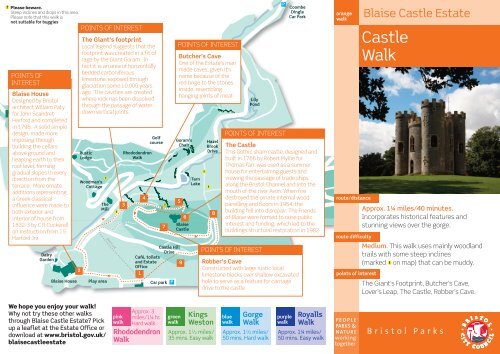
POINTS OF<br />
INTEREST<br />
<strong>Blaise</strong> House<br />
Designed by <strong>Bristol</strong><br />
architect Willaim Paty<br />
for John Scandret<br />
Harford and completed<br />
in 1798. A solid simple<br />
design, made more<br />
imposing through<br />
building the cellars<br />
above ground and<br />
heaping earth to their<br />
roof level, forming<br />
gradual slopes in every<br />
direction from the<br />
terrace. More ornate<br />
additions representing<br />
a Greek classical<br />
influence were made to<br />
both exterior and<br />
interior of house from<br />
1832-3 by C R Cockerell<br />
on instruction from J S<br />
Harford Jnr.<br />
Dairy<br />
Garden<br />
Rustic<br />
Lodge<br />
The<br />
Mill<br />
We hope you enjoy your <strong>walk</strong>!<br />
Why not try these other <strong>walk</strong>s<br />
through <strong>Blaise</strong> Castle <strong>Estate</strong>? Pick<br />
up a <strong>leaflet</strong> at the <strong>Estate</strong> Office or<br />
download at www.bristol.gov.uk/<br />
blaise<strong>castle</strong>estate<br />
2<br />
POINTS OF INTEREST<br />
The Giant’s footprint<br />
Local legend suggests that the<br />
footprint was created in a fit of<br />
rage by the Giant Goram. In<br />
fact it is an area of horizontally<br />
bedded carboniferous<br />
limestone, exposed through<br />
glaciation some 10,000 years<br />
ago. The cavities are created<br />
where rock has been dissolved<br />
through the passage of water<br />
down vertical joints.<br />
Woodman’s<br />
Cottage<br />
<strong>Blaise</strong> House Play area<br />
l!<br />
Short cut<br />
l!<br />
Rhododendron<br />
Walk<br />
3<br />
pink<br />
<strong>walk</strong><br />
4<br />
Golf<br />
course<br />
Castle Hill<br />
Drive<br />
Café, toilets<br />
and <strong>Estate</strong> 9<br />
Office<br />
1<br />
Approx. 3<br />
miles/1¼ hr.<br />
Hard <strong>walk</strong><br />
Rhododendron<br />
Walk<br />
l!<br />
7<br />
Car park P<br />
Goram’s<br />
Chair<br />
5<br />
green<br />
<strong>walk</strong><br />
POINTS OF INTEREST<br />
Butcher’s Cave<br />
One of the <strong>Estate</strong>'s man<br />
made caves, given it's<br />
name because of the<br />
red tinge to the stones<br />
inside, resembling<br />
hanging joints of meat<br />
6<br />
<strong>Blaise</strong><br />
Castle<br />
Tarn<br />
Lake<br />
l!<br />
Hazel<br />
Brook<br />
Drive<br />
l!<br />
Approx. 1 1 /2 miles/<br />
35 mins. Easy <strong>walk</strong><br />
8<br />
Lily<br />
Pond<br />
POINTS OF INTEREST<br />
POINTS OF INTEREST<br />
P<br />
Coombe<br />
Dingle<br />
Car Park<br />
The Castle<br />
This Gothic sham <strong>castle</strong>, designed and<br />
built in 1766 by Robert Mylne for<br />
Thomas Farr, was used as a summer<br />
house for entertaining guests and<br />
viewing the passage of trade ships<br />
along the <strong>Bristol</strong> Channel and into the<br />
mouth of the river Avon. When fire<br />
destroyed the ornate internal wood<br />
panelling and floors in 1954, the<br />
building fell into disrepair. The Friends<br />
of <strong>Blaise</strong> were formed to raise public<br />
interest and funding, which led to the<br />
buildings structural restoration in 1982<br />
Robber’s Cave<br />
Constructed with large rustic local<br />
limestone blocks over shallow excavated<br />
hole to serve as a feature for carriage<br />
drive to the <strong>castle</strong><br />
Kings<br />
Weston<br />
blue<br />
<strong>walk</strong><br />
Gorge<br />
Walk<br />
Approx. 1 1 /2 miles/<br />
50 mins. Hard <strong>walk</strong><br />
purple<br />
<strong>walk</strong><br />
Royalls<br />
Walk<br />
Approx. 1¼ miles/<br />
50 mins. Easy <strong>walk</strong><br />
orange<br />
<strong>walk</strong><br />
route/distance<br />
route difficulty<br />
points of interest<br />
P E O P L E<br />
PARKS &<br />
NATURE<br />
working<br />
together<br />
<strong>Blaise</strong> Castle <strong>Estate</strong><br />
Castle<br />
Walk<br />
Approx. 1¼ miles/40 minutes.<br />
Incorporates historical features and<br />
stunning views over the gorge.<br />
Medium. This <strong>walk</strong> uses mainly woodland<br />
trails with some steep inclines<br />
(marked l! on map) that can be muddy.<br />
The Giant’s Footprint, Butcher’s Cave,<br />
Lover’s Leap, The Castle, Robber’s Cave.<br />
B r i s t o l P a r k s
Welcome to <strong>Blaise</strong><br />
Castle <strong>Estate</strong><br />
<strong>Blaise</strong> <strong>Estate</strong> is a Grade II listed historic<br />
landscape with recorded human activity dating<br />
back 2,000 years. It became a ‘pleasure park’ to<br />
a variety of wealthy private owners and has<br />
been influenced through the landscape designer<br />
Humphrey Repton. It was purchased by the<br />
Corporation of <strong>Bristol</strong> in 1926 for £20,175.<br />
The Heritage Lottery funded project to restore<br />
the historic landscape and public park began in<br />
2000, with an investment of approx. £6.5 million.<br />
Modern visitor facilities such as a cafe, play area<br />
and performance space were introduced whilst<br />
the historic culture of the site was conserved.<br />
These circular guided <strong>walk</strong>s have been developed<br />
to provide reassurance and information for those<br />
who wish to experience all the estate offers.<br />
This includes spectacular views, the <strong>castle</strong> folly,<br />
lakes, scheduled ancient monuments, the<br />
18th Century mansion, unique rock formations<br />
and designed landscape features.<br />
Varying in length, all <strong>walk</strong>s will contain relatively<br />
steep ascents/descents. Care should be taken<br />
on cliff edges and steep slopes.<br />
Any feedback is always appreciated. Enjoy!<br />
contact us<br />
�<br />
Write<br />
�<br />
Web<br />
�Email<br />
�<br />
Tel<br />
<strong>Blaise</strong> Castle <strong>Estate</strong>, c/o Parks<br />
and <strong>Estate</strong>s, Colston 33,<br />
Colston Avenue, <strong>Bristol</strong> BS1 4UA<br />
www.bristol.gov.uk/<br />
blaise<strong>castle</strong>estate<br />
blaise.estate@bristol.gov.uk<br />
0117 922 3719<br />
<strong>Bristol</strong> <strong>City</strong> <strong>Council</strong> is grateful<br />
to the generous financial<br />
contribution made by the<br />
Friends of <strong>Blaise</strong> towards<br />
production of these <strong>leaflet</strong>s<br />
1<br />
2<br />
6<br />
Start at <strong>Blaise</strong> Cafe. Walk towards the <strong>Blaise</strong> House,<br />
along surfaced path with play area on left hand side.<br />
At path junction near house bear right onto path leading slightly down hill, continue on surfaced<br />
path leading down into the gorge, until you reach a set of steps on the right hand side.<br />
Giant’s Footprint<br />
3<br />
4<br />
5<br />
Take the steps leading up to the Castle. After<br />
a short distance on the right hand side you<br />
will come to a limestone pavement rock<br />
formation, known as the Giant’s Footprint.<br />
Carry on up path, passing Butcher’s Cave on<br />
the right<br />
There are two view points; the first,<br />
located on the South Bastion, takes in<br />
Sea Mills, Leigh Court and Leigh Woods.<br />
Those from the top of the path known<br />
as Lover's Leap, offer up Stoke Bishop,<br />
Sneyd Park and Dundry in the distance.<br />
Walk up to the Castle. With your back to the Castle's doors,<br />
turn left, heading towards the path leading into the woods,<br />
passing an interpretation board.<br />
Robber’s Cave<br />
7<br />
8<br />
9<br />
Follow this path on a gradual descent, then either<br />
head down the steps on the right hand side for a<br />
short cut onto the parkland, or continue over small<br />
rise passing Robber’s Cave on the left hand side.<br />
Continue following this path, down a slight<br />
descent and bearing right onto Castle Hill Drive<br />
Continue onto main field and back to Cafe.<br />
<strong>Blaise</strong> House<br />
Butcher’s Cave<br />
Lover’s Leap<br />
A map of these directions is printed over leaf.


