Registro Oficial de la RE Cotacachi Cayapas - Ministerio del Ambiente
Registro Oficial de la RE Cotacachi Cayapas - Ministerio del Ambiente
Registro Oficial de la RE Cotacachi Cayapas - Ministerio del Ambiente
Create successful ePaper yourself
Turn your PDF publications into a flip-book with our unique Google optimized e-Paper software.
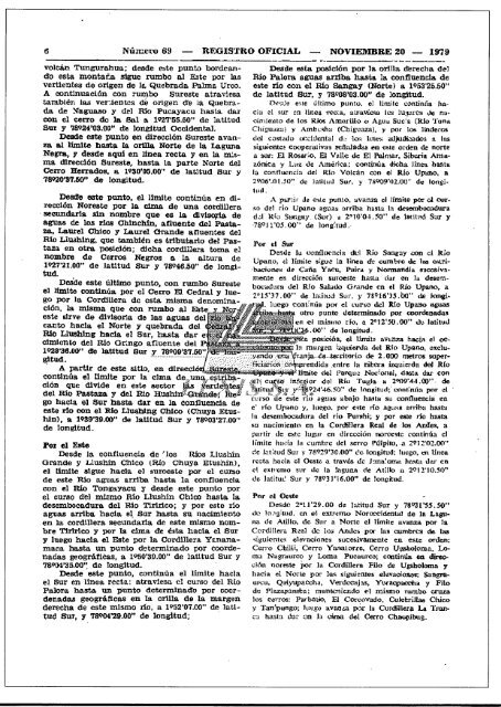
Númc1.'o 69 <strong>RE</strong>GIS'I'RO OFICIAL NOVIEMB<strong>RE</strong> 20 - 1979<br />
volcán Tungurahua; <strong>de</strong>s<strong>de</strong> este punto bor<strong>de</strong>ando<br />
esta montaña sigue rumbo al &te por <strong>la</strong>s<br />
vertientes <strong>de</strong> origen <strong>de</strong> Ia Quebrada Palma Urco,<br />
A continuación con rumbo Sureste atraviesa<br />
también <strong>la</strong>s vertíentcs dé origen d'e <strong>la</strong> Quebrada<br />
<strong>de</strong> ::-iagua.soy <strong>de</strong>l Río Pucayacu hasta dar<br />
con el cerro do <strong>la</strong> Sal a. 1927'55.50" <strong>de</strong> <strong>la</strong>titud<br />
Sur y 78924'03.00" <strong>de</strong> longitud Occi<strong>de</strong>ntal.<br />
Des<strong>de</strong> este punto en dirección Sureste avanza<br />
al límite hasta <strong>la</strong>. oríl<strong>la</strong> Norte <strong>de</strong> <strong>la</strong> Laguna<br />
Negra, '1 <strong>de</strong>s<strong>de</strong> aqui en linea recta y en <strong>la</strong> m;sma<br />
d1.recc16nSureste. hasta <strong>la</strong> parte Norte d.el<br />
Cerro lIelTados, a. 1930'05.00" <strong>de</strong> <strong>la</strong>titud Sur y<br />
78920'37.50" <strong>de</strong> longitud.<br />
Des<strong>de</strong> esta posición por <strong>la</strong>. oril<strong>la</strong> <strong>de</strong>recha <strong>de</strong>l<br />
Río Palora aguas arríba hasta <strong>la</strong> confluencia <strong>de</strong><br />
este rI0 con el RI0 Sangay (Norte) a 1953'25.50"<br />
<strong>de</strong> <strong>la</strong>titud Sur, y 78908'03.00" <strong>de</strong> longitud.<br />
Des<strong>de</strong> este últirno punto. el limite continña hacia<br />
el sur en ILne,¡¡recca, atravécsa les IU.~m:·cll d'C naoímieuto<br />
dc tos Ríos Amm-ilto () Agua Sue<strong>la</strong> (Río Tuna<br />
Chíguazu) Jo' Arnbr.sha (Chiguaza), y por los ljn<strong>de</strong>ros<br />


