Registro Oficial de la RE Cotacachi Cayapas - Ministerio del Ambiente
Registro Oficial de la RE Cotacachi Cayapas - Ministerio del Ambiente
Registro Oficial de la RE Cotacachi Cayapas - Ministerio del Ambiente
You also want an ePaper? Increase the reach of your titles
YUMPU automatically turns print PDFs into web optimized ePapers that Google loves.
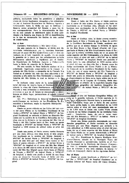
Número 69 <strong>RE</strong>GISTRO OFICIAL NOVIEMB<strong>RE</strong> 20 - 1979<br />
9<br />
pal<strong>la</strong>cta, excluyendo todas <strong>la</strong>s posesiones y adjudicaclones<br />
<strong>de</strong> tierras legalmente otorgadas a los colonizadores<br />
por el tnstíunu Ecuator<strong>la</strong>no <strong>de</strong> Retorrua Agraria y<br />
Coloniznción hasta <strong>la</strong> fecha en que se ínstituyc L:<br />
Reserva eomo propiedad <strong>de</strong>l Estado )' para los fincs<br />
correspondientes. Para. <strong>la</strong> <strong>de</strong>terminación <strong>de</strong> límites<br />
en este costado se establecerá entre el . área colo.<br />
nízada y <strong>la</strong> Reserva una franja <strong>de</strong> 500 m superficiarios,<br />
en <strong>la</strong> que se <strong>de</strong>marcarán los límites <strong>de</strong> esta unidad<br />
<strong>de</strong> coaservacién.<br />
Por el Oeste<br />
Des<strong>de</strong> el Salto <strong>de</strong>l Rio Bravo, el limite continúa<br />
por el curso <strong>de</strong> este mismo río agU¡¡~ arriba hastu su<br />
nacimiento en el Guel<strong>la</strong>je Alto, ubicado en <strong>la</strong>I\ estríbaciones<br />
más occí<strong>de</strong>ntales <strong>de</strong> <strong>la</strong> Cordll.era Sobandina<br />
<strong>de</strong> Toi ••ún, a 0923'43" <strong>de</strong> <strong>la</strong>titud Norte, y j8Q"8'O~"<br />
<strong>de</strong> longitud Occi<strong>de</strong>ntal,<br />
Por el Sur<br />
Des<strong>de</strong> el Cucl<strong>la</strong>je Alto, 'el limite l,wllnza sucesivamente<br />
hacia el Este y Noreste por 1;1 linea <strong>de</strong> cumbre<br />
Por el Este'<br />
<strong>de</strong> !a Cordillera Secundaria <strong>de</strong> Toisán, acci<strong>de</strong>nte oro-<br />
Carretera Interocéaníca )' Río Qu;j.".-COCll<br />
gráfico que es al mismo tiempo <strong>la</strong> divisoria <strong>de</strong> agl<strong>la</strong>~<br />
.En. este costado ele <strong>la</strong> Reserva, el límite está <strong>de</strong>- <strong>de</strong> los Ríos Bravo y San Miguel añuente-. ·<strong>de</strong>l Caya<br />
terminado indístintumentc pOI.' Li carretera Interoceánica<br />
por el cauce <strong>de</strong>l Rio Quijos-Coca y por e~ áren copas<br />
hacia el Norte y <strong>de</strong>l Rio Guayl<strong>la</strong>bamba hueia el Sur;<br />
sigue por <strong>la</strong> misma cordillera hasta dar er; un punto <strong>de</strong>l<br />
Ionizada en el <strong>la</strong><strong>de</strong>o izquierdo tic aquel<strong>la</strong> v<strong>la</strong> en don<strong>de</strong> curso superior <strong>de</strong>l &10 Cristopamba a <strong>la</strong> altura <strong>de</strong> 3,000<br />
<strong>la</strong> polle.'li6n <strong>de</strong> 1:1.tierra por los colonizadores se halle metros sobre el nivel <strong>de</strong>l mar R 0931'IS" <strong>de</strong> <strong>la</strong> <strong>la</strong>titud<br />
<strong>de</strong>bidamente adjuuk .•u<strong>la</strong> y legal¡izaui.l pOI' el Instítu- -:'oJortc y 711I'2R'04" <strong>de</strong> longitud. Des<strong>de</strong> esta posición el<br />
to Ecuatorieno <strong>de</strong> Reforma Agraria y COIOI1: z.rción Ifmite tom-i 121'56" <strong>de</strong> <strong>la</strong>titud Norte y 78923'48" <strong>de</strong> longitud y<br />
cunscríta<br />
butarios<br />
a el<strong>la</strong> entre los Ríos Reventador y Azue<strong>la</strong><br />
<strong>de</strong>l Río Quijos, <strong>la</strong> cual se incluye a l.,<br />
tri- <strong>de</strong>s<strong>de</strong> este punto<br />
, diagonalmente<br />
en dirección Sureste ascien<strong>de</strong> el Iímien<br />
Iínea recta, hasta. .ooirse con <strong>la</strong> orl-<br />
SCI'V¿I.<br />
tal <strong>de</strong> <strong>la</strong> Laguna <strong>de</strong> Culcocha, <strong>de</strong>5dc don-<br />
Se incluyen como parte <strong>de</strong> Ia jurisd<br />
ndo el exterior <strong>de</strong> 111 superficie Iacustre Ilesa<br />
1ol"in] <strong>de</strong>l área <strong>de</strong> reserva hacia el Occl<strong>de</strong>n<br />
. . ceográfico <strong>de</strong>l Instituto Geogrófico Mírrítorio<br />
<strong>la</strong>. cima <strong>de</strong>l Cerro Pamharnarca e<br />
.""3:2" <strong>de</strong> <strong>la</strong>titud Norte y 78921'27" do Ion-<br />
Pncarás y más evi<strong>de</strong>ncias o monumentos a<br />
ex.s.cntcs o tille en el futuro'se"eneontra~/(}::;~eS~lr~:-:';:'?~~/::~('E\t;"" .<br />
brieren en dicho<br />
<strong>de</strong>l. País<br />
lugar, perteneciente al p~ adó··::cultür~il.:.;,';:'.';'.';;'.::" ..:::;;\.<br />


