Esquema de Ordenamiento Territorial - Velez ... - CDIM - ESAP
Esquema de Ordenamiento Territorial - Velez ... - CDIM - ESAP
Esquema de Ordenamiento Territorial - Velez ... - CDIM - ESAP

You also want an ePaper? Increase the reach of your titles
YUMPU automatically turns print PDFs into web optimized ePapers that Google loves.
¿ CUÁL ES NUESTRA<br />
POBLACIÓN?<br />
Los datos Poblacionales <strong>de</strong>l municipio <strong>de</strong><br />
Vélez se encuentran registrados <strong>de</strong>s<strong>de</strong> el<br />
Censo realizado en 1912 hasta el ultimo<br />
Censo efectuado en 1993 por el<br />
Departamento Administrativo Nacional <strong>de</strong><br />
Estadística DANE, presentándose el<br />
siguiente comportamiento:<br />
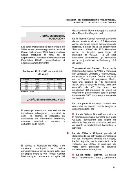
Población 1912 - 1993 <strong>de</strong>l municipio<br />
<strong>de</strong> Vélez<br />
CENSO TOTAL CABECERA RESTO<br />
1912 8238 - -<br />
1964 34115 7033 27082<br />
1973 33155 8246 24953<br />
1985 16218 7831 8180<br />
1993<br />
Fuente: DANE<br />
23563 8689 14874<br />
¿ CUÁL ES NUESTRA RED VIAL?<br />
El municipio cuenta con una red vial <strong>de</strong><br />
importancia subregional y municipal, lo<br />
cual le permite el <strong>de</strong>sarrollo <strong>de</strong><br />
activida<strong>de</strong>s <strong>de</strong> intercambio comercial,<br />
vínculos económicos, sociales y<br />
culturales <strong>de</strong> la región.<br />
El acceso al Municipio <strong>de</strong> Vélez y su<br />
cabecera municipal, se realiza<br />
principalmente a través <strong>de</strong> una ruta, que<br />
se origina sobre la Vía Troncal Central<br />
Nacional que comunica a la capital <strong>de</strong>l<br />
ESQUEMA DE ORDENAMIENTO TERRITORIAL<br />
MUNICIPIO DE VÉLEZ - SANTANDER<br />
.<br />
<strong>de</strong>partamento (Bucaramanga) y la capital<br />
<strong>de</strong> la República (Bogotá), así:<br />
De la Troncal Central Nacional, partiendo<br />
<strong>de</strong> un <strong>de</strong>svío localizado 0.7 kilómetros<br />
aprox, <strong>de</strong>l casco urbano <strong>de</strong>l municipio <strong>de</strong><br />
Barbosa, a través <strong>de</strong> la vía <strong>de</strong>nominada<br />
“Barbosa - Vélez” <strong>de</strong> 17.5 kilómetros<br />
aprox. <strong>de</strong> longitud para llegar al<br />
municipio <strong>de</strong> VELEZ, la vía esta<br />
totalmente pavimentada (7 Kilómetros<br />
aprox. en jurisdicción <strong>de</strong> Barbosa y 10.5<br />
<strong>de</strong> Vélez).<br />
Transversal <strong>de</strong>l Carare. Parte <strong>de</strong> la<br />
Cabecera Municipal <strong>de</strong> Vélez y comunica<br />
con Landazuri, Cimitarra y Puerto Araujo,<br />
conectando la troncal Central Nacional<br />
con la Troncal <strong>de</strong>l Magdalena Medio.<br />
Con una longitud <strong>de</strong> 137 kilómetros<br />
aprox, esta a cargo <strong>de</strong> Invias, tiene una<br />
extensión <strong>de</strong> 47 Km aprox. en<br />
jurisdicción <strong>de</strong>l municipio <strong>de</strong> Vélez se<br />
encuentran pavimentados para el primer<br />
trimestre <strong>de</strong>l 2003 un buen porcentaje <strong>de</strong><br />
su longitud.<br />
De otra parte el municipio cuenta con<br />
otras vías <strong>de</strong> acceso, que lo integran a<br />
otros municipios, así:<br />
La vía Vélez– Guavatá comunica a<br />
la cabecera municipal <strong>de</strong> Vélez con la <strong>de</strong><br />
Guavatá conectando una región <strong>de</strong><br />
relevante importancia a nivel económico<br />
en cuanto a productividad bocadillera y<br />
agrícola.<br />
La vía Vélez – Chipatá, permite el<br />
<strong>de</strong>sarrollo <strong>de</strong> las activida<strong>de</strong>s comerciales<br />
con los municipios vecinos <strong>de</strong> Chipatá,<br />
La Paz, Aguada, y el fortalecimiento <strong>de</strong> la<br />
vocación que <strong>de</strong>fine al municipio <strong>de</strong><br />
Vélez como prestador <strong>de</strong> servicios<br />
sociales a nivel subregional.<br />
La vía Vélez – Bolívar, Se bifurca<br />
<strong>de</strong> la Transversal el Carare y comunica a<br />
6
![PRESENTACION SIGAM MELGAR [Sólo lectura] - CDIM - ESAP](https://img.yumpu.com/19226817/1/190x132/presentacion-sigam-melgar-solo-lectura-cdim-esap.jpg?quality=85)