plan de manejo parque nacional el imposible - Portal Cuencas
plan de manejo parque nacional el imposible - Portal Cuencas
plan de manejo parque nacional el imposible - Portal Cuencas

You also want an ePaper? Increase the reach of your titles
YUMPU automatically turns print PDFs into web optimized ePapers that Google loves.
850<br />
500<br />
1050<br />
850<br />
250<br />
300<br />
500<br />
550<br />
500<br />
700<br />
750<br />
800<br />
1100<br />
1200<br />
1250<br />
750<br />
750<br />
850<br />
900<br />
850<br />
800<br />
900<br />
650<br />
650<br />
1150<br />
800<br />
800<br />
900<br />
800<br />
1100<br />
950<br />
1000<br />
900<br />
850<br />
950<br />
850<br />
200<br />
200<br />
300<br />
350<br />
550<br />
400<br />
600<br />
950<br />
900<br />
900<br />
850<br />
Cerro Segovia, 972 msnm<br />
1050<br />
1250<br />
1100<br />
1250<br />
Caserío El Naranjito<br />
Paso <strong>de</strong>l Imposible<br />
Cerro El Caballo<br />
1150<br />
1200<br />
Cerro La Cumbre<br />
1250<br />
1300<br />
Cerro Las Pirámi<strong>de</strong>s<br />
1300<br />
950<br />
1050<br />
1200<br />
1100<br />
1100<br />
1100<br />
1000<br />
1000<br />
250<br />
700<br />
Cerro La Leoncita, 1060 msnm<br />
1200<br />
1350<br />
Cerro Campana Sur, 1426 msnm<br />
250<br />
300<br />
250<br />
600<br />
1050<br />
1350<br />
1300<br />
1250<br />
150<br />
100<br />
50<br />
150<br />
150<br />
100<br />
150<br />
SAN FRANCISCO<br />
MENENDEZ<br />
250<br />
150<br />
250<br />
150<br />
100<br />
300<br />
Vivero Forestal<br />
150<br />
150<br />
250<br />
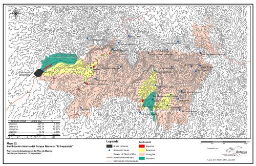
TIPO DE ZONA AREA (Ha) %<br />
Intensivo 247.07 6.20%<br />
Extensivo 646.34 16.23%<br />
Intangible 3079.17 77.31%<br />
Especial 10.43 0.26%<br />
TOTAL 3983.01 100.00%<br />
Mapa 22.<br />
Zonificación Interna <strong>de</strong>l Parque Nacional "El Imposible"<br />
100<br />
Proyecto <strong>de</strong> Actualización <strong>de</strong>l Plan <strong>de</strong> Manejo<br />
<strong>de</strong>l Parque Nacional "El Imposible"<br />
300<br />
550<br />
El Corozo<br />
200<br />
600<br />
600<br />
350<br />
300<br />
900<br />
Cerro Mixtepe, 944 msnm<br />
La Fincona<br />
Cueva <strong>de</strong> Cal<br />
Casco <strong>de</strong> la Finca El Balsamero<br />
300<br />
500<br />
800<br />
Leyenda<br />
500<br />
400<br />
Áreas Urbanas<br />
Sitios <strong>de</strong> Interés<br />
450<br />
Curvas <strong>de</strong> Niv<strong>el</strong> a 50 m<br />
Acceso Pavimentado<br />
Camino No Pavimentado<br />
500<br />
450<br />
900<br />
1050<br />
1100<br />
950<br />
500<br />
1000<br />
Mirador El Mulo<br />
Centro <strong>de</strong> Visitantes "Mixtepe"<br />
Caserío San Migu<strong>el</strong>ito<br />
Zonificación<br />
Especial<br />
Extensivo<br />
Intangible<br />
Intensivo<br />
400<br />
350<br />
Cerro Las Pulgas<br />
Mirador Cerro El León<br />
Mirador Pata <strong>de</strong> Gallina<br />
Sitio Arqueológico Piedra S<strong>el</strong>lada<br />
550<br />
450<br />
900<br />
800<br />
500<br />
900<br />
850<br />
900<br />
750<br />
Los Enganches<br />
650<br />
600<br />
900<br />
900<br />
Cerro Izcanal<br />
Cerro Piedra <strong>de</strong>l Filo<br />
750<br />
550<br />
1100<br />
850<br />
Cerro La Olla, 903 msnm<br />
Cerro Monte Hermoso<br />
1100<br />
Mirador El Puma<br />
Cerro El Pulguerón<br />
1150<br />
1200<br />
900<br />
1250<br />
1150<br />
950<br />
Preparado por:<br />
800<br />
700<br />
1200<br />
1000<br />
950<br />
700<br />
750<br />
1000<br />
1100<br />
1200<br />
850<br />
800<br />
650<br />
1150<br />
1250<br />
1250<br />
Meters<br />
0 750<br />
1,500 3,000<br />
Fuente: SIA / MARN, CNR, Julio 2007<br />
800<br />
850<br />
750<br />
800<br />
750<br />
900<br />
850