SERVICIO GEOGRÃFICO MILITAR - Ejército Nacional
SERVICIO GEOGRÃFICO MILITAR - Ejército Nacional
SERVICIO GEOGRÃFICO MILITAR - Ejército Nacional

Create successful ePaper yourself
Turn your PDF publications into a flip-book with our unique Google optimized e-Paper software.
<strong>SERVICIO</strong> GEOGRÁFICO <strong>MILITAR</strong><br />
01<br />
Precio:<br />
Price:<br />
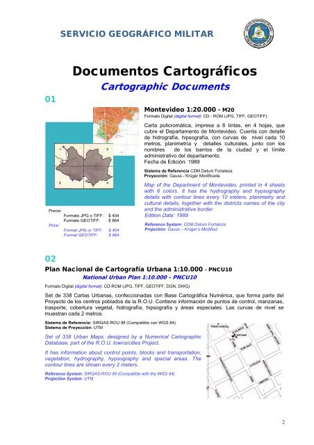
Documentos Cartográficos<br />
Formato JPG o TIFF: $ 404<br />
Formato GEOTIFF: $ 864<br />
Format JPG or TIFF: $ 404<br />
Format GEOTIFF: $ 864<br />
Cartographic Documents<br />
Montevideo 1:20.000 - M20<br />
Formato Digital (digital format): CD - ROM (JPG, TIFF, GEOTIFF).<br />
Carta policromática, impresa a 6 tintas, en 4 hojas, que<br />
cubre el Departamento de Montevideo. Cuenta con detalle<br />
de hidrografía, hipsografía, con curvas de nivel cada 10<br />
metros, planimetría y detalles culturales, junto con los<br />
nombres de los barrios de la ciudad y el límite<br />
administrativo del departamento.<br />
Fecha de Edición: 1989<br />
Sistema de Referencia CDM Datum Fortaleza<br />
Proyección: Gauss - Krüger Modificada<br />
Map of the Department of Montevideo, printed in 4 sheets<br />
with 6 colors. It has the hydrography and hypsography<br />
details with contour lines every 10 meters, planimetry and<br />
cultural details, together with the districts names of the city<br />
and the administrative border.<br />
Edition Date: 1989<br />
Reference System: CDM Datum Fortaleza<br />
Projection: Gauss – Krüger’s Modified<br />
02<br />
Plan <strong>Nacional</strong> de Cartografía Urbana 1:10.000 - PNCU10<br />
National Urban Plan 1:10.000 – PNCU10<br />
Formato Digital (digital format): CD-ROM (JPG, TIFF, GEOTIFF, DGN, DWG)<br />
Set de 338 Cartas Urbanas, confeccionadas con Base Cartográfica Numérica, que forma parte del<br />
Proyecto de los centros poblados de la R.O.U. Contiene información de puntos de control, manzanas,<br />
trasporte, cobertura vegetal, hidrografía, hipsografía y áreas especiales. Las curvas de nivel se<br />
muestran cada 2 metros.<br />
Sistema de Referencia: SIRGAS-ROU 98 (Compatible con WGS 84)<br />
Sistema de Proyección: UTM<br />
Set of 338 Urban Maps, designed by a Numerical Cartographic<br />
Database, part of the R.O.U. towns/cities Project.<br />
It has information about control points, blocks and transportation,<br />
vegetation, hydrography, hypsography and special areas. The<br />
contour lines are shown every 2 meters.<br />
Reference System: SIRGAS-ROU 98 (Compatible with the WGS 84)<br />
Projection System: UTM<br />
2