
Create successful ePaper yourself
Turn your PDF publications into a flip-book with our unique Google optimized e-Paper software.
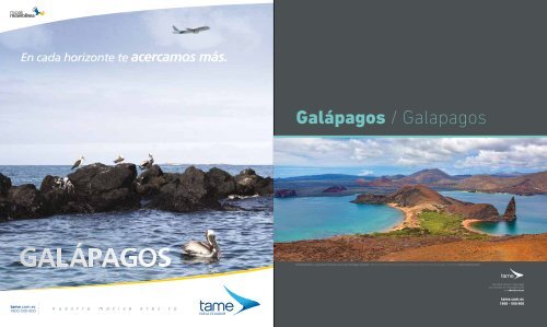
Galápagos / Galapagos<br />
Isla Bartolomé y su famoso Pináculo, con la isla Santiago al fondo / Bartolome Island and its famous Pinnacle, with the island Santiago in the back (foto: photos.<strong>com</strong>)<br />
No olvide revisar o descargar<br />
los artículos de esta publicación<br />
en: abordo.<strong>com</strong>.<strong>ec</strong><br />
tame.<strong>com</strong>.<strong>ec</strong><br />
1800 - 500 800<br />
2012 JANUARY 15 - FEBRUARY 15 / ENERO 15 - FEBRERO 15 41
GALÁPAGOS / GALÁPAGOS<br />
Galápagos<br />
El laboratorio<br />
de la evolución /<br />
The laboratory of<br />
evolution<br />
La magia de las Galápagos, su<br />
exuberante flora y fauna endémica,<br />
está más cerca gracias a los servicios de<br />
Tame. /<br />
The magic of the Galapagos Islands and<br />
their lush endemic flora and fauna is closer<br />
than ever thanks to Tame.<br />
Iguana terrestre de isla Santa Cruz / Land Iguana on Santa Cruz Island (foto: photos.<strong>com</strong>)<br />
Puerto Baquerizo Moreno es su capital. La provincia tiene<br />
dos aeropuertos: uno en Baltra, de donde se hace trasbordo<br />
a Santa Cruz, y otro en San Cristóbal. /<br />
Puerto Baquerizo Moreno is the capital of the archipelago.<br />
The province has two airports: one, on Baltra, where you can<br />
transfer to Santa Cruz; and the other, on San Cristobal.<br />
Subtropical. La temperatura varía entre 18º C y 29º C. De<br />
junio a diciembre es la estación s<strong>ec</strong>a. De enero a mayo es la<br />
estación caliente y hay más lluvias. /<br />
The islands have a subtropical climate. The temperature ranges<br />
from 18º C to 29º C. The dry season runs from June through<br />
D<strong>ec</strong>ember, while January through May is warm and rainy.<br />
Cómo llegar<br />
La provincia de Galápagos está <strong>com</strong>puesta<br />
por 13 islas grandes, 6 pequeñas, 107 islotes y<br />
rocas, todos ellos de formación volcánica. Es la<br />
única provincia insular del Ecuador, cuenta con<br />
un área total de aproximadamente 8 000 km2<br />
y cerca de 19 000 habitantes. Los aeropuertos<br />
de las islas Baltra y San Cristóbal r<strong>ec</strong>iben<br />
diariamente vuelos desde varios lugares del<br />
país. El tiempo aproximado de vuelo de Quito a<br />
Baltra es de 135 minutos. Desde Guayaquil el<br />
traslado aéreo dura cerca de 40 minutos. Una<br />
vez en Baltra se transporta a los pasajeros en<br />
ferry hasta la isla de Santa Cruz, en un tiempo<br />
máximo de 10 minutos.<br />
A San Cristóbal, en cambio, el viaje por aire<br />
desde Ecuador continental tiene una duración<br />
de alrededor de 90 minutos.<br />
Descripción general<br />
Es el centro turístico más importante del<br />
país y fue d<strong>ec</strong>larado Patrimonio Natural de la<br />
Humanidad por la Unesco en 1979. La cantidad<br />
de esp<strong>ec</strong>ies de flora y fauna endémicas que<br />
habita en este archipiélago, a partir de las<br />
cuales Charles Darwin desarrolló su Teoría<br />
de la Evolución de las Esp<strong>ec</strong>ies, le dieron el<br />
sobrenombre de islas encantadas. Galápagos<br />
se encuentra a 950 km del Ecuador continental<br />
y además de su exuberante belleza y encanto<br />
natural cuenta con cuatro islas habitadas.<br />
Estas son Santa Cruz, San Cristóbal, Isabela y<br />
Floreana.<br />
La isla con mayor infraestructura turística<br />
es Santa Cruz. Con 982 Km2, es también la<br />
segunda más grande del archipiélago. Ofr<strong>ec</strong>e<br />
una variedad en alojamiento: desde opciones<br />
para aventureros hasta exclusivos hoteles. En<br />
su capital, Puerto Ayora, se encuentran algunos<br />
de los más importantes operadores turísticos de<br />
la provincia. En San Cristóbal se halla la capital<br />
de la provincia, Puerto Baquerizo Moreno. Esta<br />
ciudad ofr<strong>ec</strong>e igualmente buena infraestructura<br />
turística y varios operadores turísticos.<br />
Isabela y Floreana, por su parte, son<br />
r<strong>ec</strong>onocidas <strong>com</strong>o dos de las islas más bellas<br />
de las Galápagos. Cuentan con pocas opciones<br />
de alojamiento y no disponen de aeropuertos,<br />
por lo que se accede a ellas vía marítima. En<br />
el resto de islas, aunque no están habitadas,<br />
existen también atractivos naturales de belleza<br />
inigualable.<br />
Fiestas<br />
Febrero 12 - 18: Fiestas de provincialización. /<br />
How to get there<br />
The province of Galapagos has 13 large islands<br />
and six small islands, with 107 rocks and islets,<br />
all formed by volcanic activity. It is the only<br />
island province in Ecuador, with an approximate<br />
total land area of 8,000 Km2 and nearly 19,000<br />
residents. The airports on the islands of Baltra<br />
and San Cristobal wel<strong>com</strong>e daily flights from<br />
different parts of the country. The approximate<br />
flight time from Quito to Baltra is 135 minutes.<br />
From Guayaquil, the flight takes around 40<br />
minutes. Upon arrival at the Isla Baltra Airport,<br />
a 10-minute transfer across the Itabaca Strait<br />
must be taken in order to reach the island of<br />
Santa Cruz.<br />
The flight to San Cristobal Island from the<br />
mainland is approximately 90 minutes.<br />
General description<br />
The archipelago is the most important tourist<br />
destination in the country, and Unesco d<strong>ec</strong>lared<br />
the islands a Cultural Heritage of Humanity<br />
Site in 1979. The amount of endemic flora and<br />
fauna sp<strong>ec</strong>ies that inhabit the chain of islands,<br />
which were the basis of Charles Darwin’s Theory<br />
of Evolution of Sp<strong>ec</strong>ies, gave the Galapagos<br />
their nickname, “the enchanted islands.” The<br />
Galapagos are located 950 Km from Ecuador’s<br />
mainland. In addition to their amazing beauty<br />
and natural enchantment, the archipelago<br />
includes four inhabited islands, which are Santa<br />
Cruz, San Cristobal, Isabella and Floreana.<br />
The island with the best infrastructure is Santa<br />
Cruz, which is the s<strong>ec</strong>ond largest island in the<br />
Galapagos Archipelago, with a surface area<br />
covering 982 Km2. It offers a variety of lodging<br />
options, ranging from adventure lodges to<br />
exclusive hotels. The island’s capital, Puerto<br />
Ayora, is the location of some of the most<br />
important tourism operators in the province.<br />
San Cristobal Island is the hope to the capital of<br />
the province, Puerto Baquerizo Moreno. This city<br />
also offers good tourism infrastructure and a<br />
variety of tourism operators.<br />
Additionally, Isabella and Floreana islands are<br />
r<strong>ec</strong>ognized as two of the most beautiful islands in<br />
the Galapagos. They offer few lodging options and<br />
do not have airports, and thus must be accessed<br />
by water. Although the remaining islands are not<br />
inhabited, they offer a great amount of attractions<br />
with unsurpassable beauty.<br />
Festivals<br />
February 12 - 18: Festival celebrating be<strong>com</strong>ing a province. /<br />
42 ENERO 15 - FEBRERO 15 / JANUARY 15 - FEBRUARY 15 2012 2012 JANUARY 15 - FEBRUARY 15 / ENERO 15 - FEBRERO 15 43
GALÁPAGOS/ GALÁPAGOS<br />
Qué ver o hacer / Things to do and see<br />
Qué ver o hacer / Things to do and see<br />
Santa Cruz San Cristóbal<br />
Mal<strong>ec</strong>ón de Puerto Ayora - Mal<strong>ec</strong>ón de Puerto Baquerizo Moreno / Puerto Ayora Pier - Sea Lions at Bachas Beach - Puerto Baquerizo Moreno Pier (fotos: ABORDO)<br />
Isabela Otras islas<br />
El segundo cráter más grande del mundo / The s<strong>ec</strong>ond largest crater in the world - Lobos marinos en Bahía Darwin / Sea Lions in Darwin Bay (fotos: Fernando Adrián Serra - ABORDO)<br />
Estación Charles Darwin (Santa Cruz)<br />
Centro de investigación. Hay un criadero de<br />
tortugas gigantes. Se puede observa también<br />
fragatas, lobos marinos, piqueros, etc. /<br />
Research center, which includes a giant tortoise<br />
hatchery. Additionally, frigate birds, seals and<br />
boobies, etc. can be observed.<br />
www.santacruz.gob.<strong>ec</strong><br />
Al sur de la isla /<br />
Located on the southern part of the island.<br />
El Garrapatero (Santa Cruz)<br />
Playa de agua color turquesa. Detrás de ella<br />
hay una laguna con flamencos y patillos. Es<br />
fácil observar pinzones y otras aves. /<br />
Beach with turquoise blue water. Behind the<br />
beach is a lake full of flamingos and pintails. It<br />
is also easy to observe finches and other birds.<br />
www.santacruz.gob.<strong>ec</strong><br />
Al este de Bellavista. Puede llegar en taxi./Located to<br />
the east of Bellavista. Can be accessed by taxi.<br />
Las Grietas (Santa Cruz)<br />
Formación rocosa atravesada por lagunas de<br />
agua dulce y salada. Permite observación de<br />
aves de la zona. Ideal para kayak y snorkel. /<br />
Rocky formation surrounded by saltwater and<br />
freshwater lakes. Birds of the zone can be<br />
observed. Ideal for kayaking and snorkeling.<br />
www.santacruz.gob.<strong>ec</strong><br />
A 3 km de Puerto Ayora. /<br />
Located 3 km from Ayora Port.<br />
Los Gemelos (Santa Cruz)<br />
Grandes depresiones de origen volcánico,<br />
donde se encuentra el bosque de Escal<strong>ec</strong>ia y<br />
se visibilizan pinzones y pájaros brujos. /<br />
Large volcanic craters where the Escal<strong>ec</strong>ia<br />
forest is found and finches and vermilion<br />
flycatchers can be seen.<br />
www.santacruz.gob.<strong>ec</strong><br />
A 30 minutos de Puerto Ayora, en taxi. / 30 minutes<br />
from Ayora Port by taxi.<br />
Isla Lobos / Lobos Island (San Cristóbal)<br />
Se encuentra a 8 km de Puerto Baquerizo<br />
Moreno. Por su rica flora y fauna marina es<br />
un sitio ideal para practicar snorkel y buceo. /<br />
Located 8 km from Puerto Baquerizo Moreno.<br />
Due to its wealth of marine flora and fauna, this<br />
is an ideal spot for snorkeling and scuba diving.<br />
www.<strong>ec</strong>ostravel.<strong>com</strong><br />
Noreste de la isla /<br />
Northeastern part of the island<br />
La Lobería (San Cristóbal)<br />
Playa de arena coralina. Está protegida por<br />
arr<strong>ec</strong>ifes. Es <strong>com</strong>ún observar lobos e iguanas<br />
marinas descansando en los alrededores. /<br />
Beach with coralline sand. It is prot<strong>ec</strong>ted by<br />
reefs. It is <strong>com</strong>mon to see seals and marine<br />
iguanas resting in the surrounding areas.<br />
www.galapagospark.org<br />
A 10 minutos del aeropuerto. / Located 10 minutes<br />
from the airport.<br />
Bahía Urbina / Urbina Bay (Isabela)<br />
Se puede observar iguanas terrestres. En la<br />
parte rocosa se ven piqueros de patas azules,<br />
pingüinos, iguanas marinas, etc. /<br />
Land iguanas can be seen here. Blue-footed<br />
boobies, penguins and marine iguanas, etc. can<br />
be seen on the rocks.<br />
www.naturegalapagos.<strong>com</strong><br />
Ubicada en la costa Oeste de la isla. / Located on<br />
the western coast of the island.<br />
Islote Tortuga / Tortuga Islet (Isabela)<br />
Es una caldera parcialmente sumergida y un<br />
lugar idóneo para practicar buceo y snorkel.<br />
Se presta para la observación aves. /<br />
This is a partially submerged crater that is ideal<br />
for scuba diving and snorkeling in addition to<br />
bird watching.<br />
www.visitisabela.<strong>com</strong><br />
A 15 km de Puerto Villamil. /<br />
Located 15 km from Villamil Port.<br />
Bahía del Correo (Floreana)<br />
Sitio histórico en el que marinos y piratas<br />
del siglo XVIII dejaban su correspondencia,<br />
utilizando un barril cual oficina de correo. /<br />
Historic site where seamen and pirates left<br />
correspondence in the XVIII century, using a<br />
barrel as a ‘post office.’<br />
www.<strong>ec</strong>ostravel.<strong>com</strong>/ En minutos se llega por tierra,<br />
desde Pto. Velasco Ibarra./ It can be reached by land<br />
in only a few minutes from Velasco Ibarra Port.<br />
Corona del Diablo (Floreana)<br />
Se trata de un cono volcánico que impresiona<br />
a los visitantes. Es uno de los mejores sitios<br />
en Galápagos para realizar snorkel y buceo. /<br />
This is the peak of a volcano that impresses<br />
tourists. It is one of the best areas in the<br />
Galapagos for snorkeling and scuba diving.<br />
www.<strong>ec</strong>ostravel.<strong>com</strong> / Al noreste de Floreana, cerca<br />
de Punta Cormorant. / It is located to the northeast<br />
of Floreana Island, near the Cormorant Point coast.<br />
Bahía Darwin (Genovesa)<br />
Lugar ideal para observar aves. Se formó<br />
cuando el cráter más grande de la isla se<br />
hundió en el mar, hace millones de años. /<br />
The preferred site for bird watching. It was<br />
formed when the largest crater on the island<br />
sunk into the sea millions of years ago.<br />
www.galapagos-islands-tourguide.<strong>com</strong>/<br />
Sur de la isla Genovesa /<br />
South of the Genovesa island<br />
Laguna de Agua Salada (Rábida)<br />
Laguna habitada por colonias de flamencos<br />
rosados, pinzones de Darwin y piqueros. En<br />
los alrededores hay lobos marinos. /<br />
This lake is inhabited by pink flamingos, Darwin<br />
finches and boobies. It is <strong>com</strong>mon to see seals<br />
in the surrounding areas.<br />
www.galapagoscruisesdiscover.<strong>com</strong>/ A pocos<br />
minutos del desembarque. / The lake is located only<br />
a few minutes from the disembarking point.<br />
Galapaguera Cerro Colorado (Santa Cruz)<br />
Se trata de un centro de crianza y prot<strong>ec</strong>ción<br />
de tortugas Galápagos. Queda en la parte alta<br />
de la isla, a unos 45 minutos del mal<strong>ec</strong>ón. /<br />
This is a hatchery and reserve for Galapagos<br />
tortoises. Located on the high part of the island,<br />
approximately 45 minutes from the pier.<br />
www.galapagospark.org<br />
Sureste de la isla, a 22,4 km de la zona costera /<br />
Southeastern of the island, 22.4 km from the coast.<br />
Puntudo, Media Luna, Crocker (Santa Cruz)<br />
Son las mayores elevaciones de Santa Cruz.<br />
Desde ella se obtiene una grandiosa vista de<br />
la isla y sus alrededores. /<br />
The largest hills on Santa Cruz. An amazing<br />
view of the island and the surrounding areas<br />
can be seen from these hills.<br />
www.santacruz.gob.<strong>ec</strong><br />
El sendero inicia en el Parque Bellavista. / The hill<br />
begins in Bellavista Park.<br />
Tortuga Negra (Santa Cruz)<br />
Complejo formado por entradas de mar. Sitio<br />
de reposo de rayas, tiburones y tortugas de<br />
mar. Alrededor cr<strong>ec</strong>en esp<strong>ec</strong>ies de mangle. /<br />
Complex made up of ocean inlets. This is a resting<br />
area for rays, sharks and sea turtles. Mangrove<br />
sp<strong>ec</strong>ies grow in the surrounding areas.<br />
www.santacruz.gob.<strong>ec</strong><br />
De Baltra salen pangas que lo llevarán. / Canoes<br />
can bring you to this location from Baltra.<br />
Hacienda Tranquila (San Cristóbal)<br />
Experiencia de agroturismo. Los voluntarios<br />
colaboran con la hacienda y la <strong>com</strong>unidad.<br />
Está en la parte alta de la isla. /<br />
Experience agro-tourism. The volunteers<br />
collaborate with the hacienda and the<br />
<strong>com</strong>munity. Located on the high part.<br />
www.haciendatranquila.<strong>com</strong><br />
Parte alta de la isla /<br />
High part of the island.<br />
Puerto Chino / Chino Port (San Cristóbal)<br />
Playa de arena blanca, a 45 minutos de la<br />
zona costera. Es el lugar ideal para descansar<br />
después de visitar la parte alta de la isla. /<br />
White sand beach, located 45 minutes from the<br />
coast. This is a perf<strong>ec</strong>t area to rest after visiting<br />
the upper part of the island.<br />
www.galapagospark.org<br />
24,5 km de Puerto Baquerizo Moreno. / 24.5 km<br />
from Puerto Baquerizo Moreno<br />
Punta Pitt / Pitt Point (San Cristóbal)<br />
Ofr<strong>ec</strong>e una vista esp<strong>ec</strong>tacular de la isla. Se<br />
puede observar esp<strong>ec</strong>ies de piqueros. Está a<br />
55 km por mar de Puerto Baquerizo Moreno./<br />
Offers a sp<strong>ec</strong>tacular view of the island. You can<br />
see boobies here. This is located 55 km by sea<br />
from Puerto Baquerizo Moreno.<br />
www.<strong>ec</strong>ostravel.<strong>com</strong><br />
Extremo este de la isla. /<br />
Far eastern part of the island.<br />
Los Cuatro Hermanos (Isabela)<br />
Santuario de aves, conformado por cuatro<br />
islotes pequeños. El desembarque está prohibido<br />
pero es un sitio ideal para bucear. /<br />
A bird sanctuary made up of four small islets.<br />
Disembarking is prohibited, but it is an ideal site<br />
for scuba diving.<br />
www.visitisabela.<strong>com</strong><br />
A 45 minutos en lancha de Puerto Villamil /<br />
Located 45 minutes by boat from Villamil Port.<br />
Muro de las lágrimas (Isabela)<br />
Es un muro construido con bloques de lava,<br />
de 100 m de largo y 7 m de alto. Lo hicieron<br />
los presos de una cárcel del siglo pasado. /<br />
A 100 meter-long, 7 meter-high wall built with<br />
blocks of lava. Prisoners built the wall during<br />
the last century.<br />
www.visitisabela.<strong>com</strong><br />
Se puede llegar a pie, en bicicleta o en auto./ Can be<br />
reached by foot, bicycle or vehicle.<br />
Punta Cormorant (Floreana)<br />
Playas con arena de diferentes colores, lagunas<br />
con flamencos, formaciones volcánicas y<br />
arr<strong>ec</strong>ifes ideales para buceo y snorkel. /<br />
Includes beaches with different colored sand,<br />
lakes with flamingos, and volcanoes and reefs<br />
ideal for scuba diving and snorkeling.<br />
www.<strong>ec</strong>ostravel.<strong>com</strong> / Se accede caminando por<br />
un sendero de 720 metros. / It can be reached by<br />
walking along a 720-meter long path.<br />
Cerro Alieri / Alieri Hill (Floreana)<br />
Elevación que se esconde entre un bosque<br />
s<strong>ec</strong>o tropical y peñascos. Ofr<strong>ec</strong>e una vista<br />
extraordinaria de la majestuosidad de la isla./<br />
This hill includes a dry tropical forest and rock<br />
formations. It offers an extraordinary view of all<br />
that the island has to offer.<br />
www.galapagospark.org<br />
Este de Puerto Velasco Ibarra. / Located to the east<br />
of Velasco Ibarra Port<br />
Punta Suárez / Suarez Point (Española)<br />
Es un punto rocoso que contiene varias<br />
colonias de aves marinas de Galápagos.<br />
Cuenta con un hermoso acantilado. /<br />
A rocky point that has various colonies of<br />
marine birds typical of the Galapagos Islands.<br />
Has a beautiful cliff that captivates tourists.<br />
www.galapagoscruisesdiscover.<strong>com</strong><br />
Isla Española. /<br />
Española Island.<br />
Punta Espinosa (Fernandina)<br />
Manglares, garzas, pelícanos, pinzones, lobos<br />
de mar, iguanas marinas endémicas. En este<br />
lugar habita el pingüino de Galápagos./<br />
Mangroves with herons, pelicans, boobies, seals<br />
and endemic marine iguanas. Additionally, this is<br />
an area that penguins inhabit in the Galapagos.<br />
www.crucerosgalapagos.<strong>com</strong><br />
Isla Fernandina /<br />
Fernandina Island<br />
44 ENERO 15 - FEBRERO 15 / JANUARY 15 - FEBRUARY 15 2012 2012 JANUARY 15 - FEBRUARY 15 / ENERO 15 - FEBRERO 15 45
GALÁPAGOS / GALÁPAGOS<br />
Dónde Dormir/ Lodging<br />
Casa Blanca (San Cristóbal)<br />
Desde USD 50 / Starting at 50 dollars<br />
Frente al mal<strong>ec</strong>ón / Front of pier<br />
www.casablancagalapagos.<strong>com</strong><br />
(593) (05) 2520 392<br />
Red Mangrove (Santa Cruz)<br />
Desde USD 192 / Starting at 192 dollars<br />
Av. Charles Darwin, Puerto Ayora<br />
www.redmangrove.<strong>com</strong><br />
(593) (02) 3823 941<br />
Hotel Miconia (San Cristóbal)<br />
Desde USD 65 / Starting at 65 dollars<br />
Av. Charles Darwin<br />
www.miconia.<strong>com</strong><br />
(593) (05) 2521 177<br />
La Casa de Marita (Isabela)<br />
Desde USD 55 / Starting at 55 dollars<br />
Puerto Villamil<br />
www.galapagosisabela.<strong>com</strong><br />
(593) (05) 2529301<br />
El portal web de la agencia de viajes líder en<br />
el mercado <strong>ec</strong>uatoriano. ¡Todo lo que n<strong>ec</strong>esitas<br />
para tu viaje en un solo click! /<br />
The website of the leading travel agency in the<br />
Ecuadorian market. All you need in a single<br />
click!<br />
www.metropolitantouring.<strong>com</strong>.<strong>ec</strong><br />
MetropolitanTouringAgenciaOnline<br />
MetroTouringEc<br />
Royal Palm (Santa Cruz)<br />
Desde USD 425 / Starting at 425 dollars<br />
Km 18 vía Baltra<br />
www.royalpalmgalapagos.<strong>com</strong><br />
(593) (02) 2526 874<br />
Finch Bay (Santa Cruz)<br />
Desde USD 264 / Starting at 264 dollars<br />
Barrio Punta Estrada, Puerto Ayora<br />
www.finchbayhotel.<strong>com</strong><br />
(593) (02) 2988 200<br />
Iguana Crossing (Isabela)<br />
Desde USD 311 / Starting at 311 dollars<br />
Av. Antonio Gil, Puerto Villamil<br />
www.iguanacrossing.<strong>com</strong>.<strong>ec</strong><br />
(593) (02) 6046 800 Ext. 109<br />
Pensión Wittmer (Floreana)<br />
Desde USD 30 / Starting at 30 dollars<br />
Puerto Velasco Ibarra<br />
www.margret-wittmer.<strong>com</strong><br />
(593) (05) 2524 873<br />
Piquero de patas azules, en Santa Cruz / Blue-footed booby, in Santa Cruz (foto: ABORDO)<br />
46 ENERO 15 - FEBRERO 15 / JANUARY 15 - FEBRUARY 15 2012
Costa / Coast<br />
Deportes extremos en Same / Same Extreme Sports (foto: ABORDO)<br />
No olvide revisar o descargar<br />
los artículos de esta publicación<br />
en: abordo.<strong>com</strong>.<strong>ec</strong><br />
tame.<strong>com</strong>.<strong>ec</strong><br />
1800 - 500 800
COSTA / ESMERALDAS<br />
Esmeraldas<br />
Capital<br />
<strong>ec</strong>uatoriana de<br />
la cultura afro /<br />
Ecuadorian capital<br />
of Afro culture<br />
Exuberante vegetación, rica historia<br />
y hermosas playas le esperan en la<br />
Provincia Verde. /<br />
Exuberant vegetation, rich history and<br />
beautiful beaches await in the Green<br />
Province.<br />
El aeropuerto de Esmeraldas (30 minutos de la ciudad)<br />
cuenta con vuelos dir<strong>ec</strong>tos de Tame, desde Quito o<br />
Guayaquil que tardarán 30 y 50 minutos resp<strong>ec</strong>tivamente. /<br />
Tame offers dir<strong>ec</strong>t flights to the Esmeraldas Airport (30<br />
minutes from the city) from Quito or Guayaquil that last 30 and<br />
50 minutes, resp<strong>ec</strong>tively.<br />
El clima varía entre tropical subhúmedo, subtropical<br />
húmedo y subtropical muy húmedo. La temperatura oscila<br />
entre 21º C y 25º C. /<br />
The climate ranges between slightly humid tropical, humid<br />
subtropical and very humid subtropical. The temperature<br />
ranges from 21º C to 25º C.<br />
Cómo llegar<br />
Su exuberante vegetación le dio el sobrenombre<br />
de la Provincia Verde. Consta de ocho cantones,<br />
entre los que se destacan su capital homónima,<br />
Atacames, Muisne y San Lorenzo. Limita al<br />
Norte con Colombia, al Sur con Manabí, al Este<br />
con Carchi y al Oeste con el Océano Pacífico.<br />
El aeropuerto, ubicado en la ciudad de Tachina<br />
(a 30 minutos de la capital Esmeraldas), es la<br />
puerta de acceso a esta encantadora provincia.<br />
Tame ofr<strong>ec</strong>e vuelos dir<strong>ec</strong>tos que tardan<br />
entre 30 y 60 minutos desde Quito (300 km) y<br />
Guayaquil (447 km), resp<strong>ec</strong>tivamente.<br />
Descripción general<br />
Cuenta con cerca de 460 600 habitantes. Su<br />
extensión <strong>com</strong>prende 15 260 km2, en los<br />
cuales encontrará vías de primer nivel para<br />
acceder a r<strong>ec</strong>orridos turísticos <strong>com</strong>o La Ruta<br />
del Spondylus, que ofr<strong>ec</strong>e un tour para conocer<br />
algunos de los vestigios arqueológicos más<br />
importantes del Ecuador.<br />
Esmeraldas es una de las provincias más<br />
turísticas del país, debido a que en ella se<br />
pueden encontrar gran cantidad de actividades<br />
de aventura, <strong>ec</strong>oturismo, turismo <strong>com</strong>unitario,<br />
historia, relajación y cultura. Esmeraldas<br />
además es la tierra de ritmos tradicionales<br />
<strong>com</strong>o la marimba y el arrullo.<br />
El cantón Atacames alberga algunas de las<br />
playas más visitadas del Ecuador, tales <strong>com</strong>o<br />
Atacames, Tonsupa y Mompiche. En estos<br />
balnearios naturales, además de hermosas<br />
playas, gente encantadora y centros de<br />
diversión nocturna, encontrará una variedad<br />
de opciones hoteleras que se ajustan a<br />
diversos presupuestos, así <strong>com</strong>o lugares para<br />
disfrutar de una exquisita <strong>com</strong>ida, <strong>com</strong>puesta<br />
principalmente por frutos del mar.<br />
Otras de las actividades apr<strong>ec</strong>iadas por los<br />
turistas nacionales y extranjeros son visitar las<br />
bellas playas de Súa, Tonchigüe, Muisne, Playa<br />
Escondida, Las Palmas, Las Peñas y Cauchal,<br />
además del Parque Arqueológico La Tolita,<br />
viajar en tren a San Lorenzo, caminar por la<br />
Reserva Ecológica Cayapas - Mataje y Mache-<br />
Chindul, entre otros.<br />
Fiestas<br />
Febrero (finales del mes): carnaval<br />
Marzo (primeros días del mes): Festival Internacional de<br />
Música y Danza Afro<br />
Abril: Semana Santa<br />
Junio (finales del mes): Fiesta de San Pedro y San Pablo<br />
5 de Agosto: Independencia de Esmeraldas<br />
Octubre: mes de la Cultura Afro. /<br />
How to get there<br />
The wealth of vegetation provided its nickname,<br />
the Green Province. Esmeraldas has eight<br />
cantons, among the most important Esmeraldas,<br />
Atacames, Muisne and San Lorenzo. The<br />
province is bordered to the north by Colombia,<br />
to the south by Manabi, to the east by Carchi,<br />
and to the west by the Pacific Ocean. The airport,<br />
located in the city of Tachina (30 minutes from<br />
the capital of Esmeraldas), is the gateway to this<br />
enchanting province. Tame offers dir<strong>ec</strong>t flights<br />
that last 30 and 60 minutes from Quito (300 Km)<br />
and Guayaquil (447 Km), resp<strong>ec</strong>tively.<br />
General description<br />
The province has 460,600 residents, covering an<br />
area of 15,260 km2, with first class roadways<br />
that run to various tourist destinations, such as<br />
the Route of the Spondylus, which offers a tour<br />
of some of the most important archaeological<br />
sites in Ecuador.<br />
Esmeraldas is one of the provinces in the<br />
country that r<strong>ec</strong>eives the highest amount of<br />
tourism, due to the large amount of adventure,<br />
<strong>ec</strong>otourism, <strong>com</strong>munity tourism, history,<br />
relaxation and cultural activities. Additionally,<br />
Esmeraldas is the land of traditional rhythms,<br />
such as marimba and arrullo.<br />
The canton of Atacames is home to some of<br />
the most visited beaches in Ecuador, such as<br />
Atacames, Tonsupa and Mompiche. In addition<br />
to the beautiful beaches, friendly people and<br />
nightlife, these natural swimming areas offer<br />
a great variety of lodging options that meet all<br />
budgets, as well as places to enjoy the exquisite<br />
cuisine, which primarily uses seafood.<br />
Other activities enjoyed by national and foreign<br />
travelers include visiting the beautiful beaches<br />
of Sua, Tonchigüe, Muisne, Playa Escondida, Las<br />
Palmas, Las Peñas and Cauchal, in addition to La<br />
Tolita Archaeological Park, traveling by train to<br />
San Lorenzo, and walking through the Cayapas –<br />
Mataje and Mache-Chindul Ecological Reserves,<br />
among others.<br />
Festivals<br />
February: Carnaval (end of the month)<br />
March: International Afro Music and Dance Festival<br />
(beginning of the month)<br />
April: Holy week<br />
June: Festivals of San Pedro and San Pablo (end of the month)<br />
August 5: Independence Day of Esmeraldas<br />
October: Afro culture month. /<br />
50 ENERO 15 - FEBRERO 15 / JANUARY 15 - FEBRUARY 15 2012 2012 JANUARY 15 - FEBRUARY 15 / ENERO 15 - FEBRERO 15 51
COSTA / ESMERALDAS<br />
Qué ver o hacer / Things to do and see<br />
Advantage Manabí<br />
Playas de Atacames / Atacames Beach - Atard<strong>ec</strong>er en Mompiche / Sunset in Mompiche - A bote por el río Cayapas / Boat trip down the river Cayapas (fotos: ABORDO - José Salvador - Iván Boada)<br />
Atacames /<br />
Atacames<br />
Mompiche /<br />
Mompiche<br />
Reserva Cayapas-Mataje /<br />
Cayapas-Mataje Reserve<br />
Es una de las playas más concurridas de la<br />
provincia y el país. Excelente infraestructura<br />
hotelera. Ofr<strong>ec</strong>e una esp<strong>ec</strong>tacular vida nocturna. /<br />
It is one of the most visited beaches in the<br />
province and the country. It offers excellent hotel<br />
infrastructure, in addition to sp<strong>ec</strong>tacular nightlife.<br />
Está ubicada a 38 km de la ciudad de Esmeraldas y a 350 km<br />
de Quito. / It is located at 38 km from the city of Esmeraldas<br />
and 350 km from Quito. www.turismoesmeraldas.<strong>com</strong><br />
Es una playa de arena oscura que encanta a los<br />
turistas. Es ideal para practicar surf y una de las<br />
playas más tranquilas de la provincia. /<br />
A beach with dark sand that is enchanting for<br />
tourists. It is ideal for surfing and one of the calmest<br />
beaches in the province.<br />
Ubicada en el cantón Muisne, a 400 km de Quito (aprox.). /<br />
It is located in the canton of Muisne, approximately 400 km<br />
from Quito. www.turismoesmeraldas.<strong>com</strong><br />
Cuenta con un bosque de manglar conformado por<br />
cuatro variedades de mangle. Es una zona de gran<br />
biodiversidad en su flora y fauna./<br />
Includes a mangrove forest with four different types<br />
of mangroves. It is an area with significant flora and<br />
fauna biodiversity.<br />
Se encuentra entre los cantones San Lorenzo y Eloy Alfaro. /<br />
It is located in the cantons of San Lorenzo and Eloy Alfaro.<br />
www.codeso.<strong>com</strong><br />
Dónde Dormir/ Lodging<br />
El Marqués Hotel (Atacames)<br />
Desde USD 61 / Starting at 61 dollars<br />
Mal<strong>ec</strong>ón de la playa y Los Crotos<br />
www.elmarqueshotel.<strong>com</strong><br />
(593) (6) 2731 172<br />
Muisne<br />
Localidad de tranquilas playas. Ofr<strong>ec</strong>e<br />
turismo <strong>com</strong>unitario en las localidades<br />
cercanas al <strong>ec</strong>osistema de manglar. /<br />
Small <strong>com</strong>munity with calm beaches. Offers<br />
<strong>com</strong>munity tourism options in the areas<br />
surrounding the mangrove <strong>ec</strong>osystem.<br />
www.fund<strong>ec</strong>ol.org<br />
Oeste de la provincia. / Western part of the province.<br />
Reserva Mache-Chindul / Ecological Reserve<br />
Santuario natural de 70 mil h<strong>ec</strong>táreas con<br />
bosques húmedos tropicales y cascadas. La<br />
<strong>com</strong>unidad indígena Los Chachis habita aqui. /<br />
A 70,000-h<strong>ec</strong>tare nature sanctuary with tropical<br />
rainforests and waterfalls. The Los Chachis<br />
indigenous <strong>com</strong>munity lives here.<br />
www.codeso.<strong>com</strong><br />
Acceso desde Esmeraldas, Atacames o Muisne. / Can<br />
be accessed from Esmeraldas, Atacames or Muisne.<br />
Same<br />
Descubra una de las playas más hermosas<br />
y exclusivas. Podrá encontrar el <strong>com</strong>plejo<br />
hotelero Casa Blanca, construcción de estilo<br />
mediterráneo. / Discover one of the most<br />
beautiful and exclusive beaches of Ecuador. You<br />
can find the Casa Blanca tourism <strong>com</strong>plex, a<br />
Mediterranean style building.<br />
A 6 km de Atacames. / At 6 km from Atacames<br />
Súa<br />
Está en una zona de bosque s<strong>ec</strong>o tropical.<br />
Sus hermosas playas son óptimas para nadar<br />
y disfrutar de la tranquilidad del océano. /<br />
Located in a dry tropical forest. Its beautiful<br />
beaches are perf<strong>ec</strong>t for swimming and enjoying<br />
the tranquility of the ocean.<br />
www.viajandox.<strong>com</strong><br />
Alrededor de 6 km de Atacames. / Approximately at<br />
6 km from Atacames.<br />
Tonchigüe<br />
Playa de arena fina de 4 km de extensión,<br />
está rodeada de cocoteros y pastizales. Se<br />
puede observar gaviotas y gallinazos. /<br />
A 4 km long beach with fine sand, surrounded<br />
by coconut palms and pastures. Seagulls and<br />
chicken hawks can be found in the area.<br />
www.viajandox.<strong>com</strong><br />
18 km de Atacames. / At 18 km from Atacames<br />
Tonsupa<br />
Es una playa tranquila de hermosas olas y<br />
arena limpia. Tiene <strong>com</strong>pleta infraestructura<br />
hotelera y un ambiente agradable. /<br />
A calm beach with beautiful waves and clean<br />
sand. Includes <strong>com</strong>plete hotel infrastructure<br />
and an enjoyable environment.<br />
www.turismoesmeraldas.<strong>com</strong><br />
26 km al suroeste de Esmeraldas. /<br />
26 km to the southwest of Esmeraldas.<br />
Hotel Juan Sebastian (Atacames)<br />
Desde USD 60 / Starting at 60 dollars<br />
Frente a la playa de Atacames<br />
www.hoteljuansebastian.<strong>com</strong><br />
(593) (6) 2731 049<br />
Hotel Club del Sol (Atacames)<br />
Desde USD 55 / Starting at 55 dollars<br />
Frente a la playa de Atacames<br />
www.hotelclubdelsol.<strong>com</strong><br />
(593) (6) 2760 660<br />
Hostería El Rampiral (Same)<br />
Desde USD 71,98 / Starting at 71.98 dollars<br />
Vía Atacames - Muisne, playa de Same<br />
www.wix.<strong>com</strong>/rampiral/rampiral<br />
(593) (2) 2264 134 / 085990806<br />
Hotel Puerto Ballesta (Tonsupa)<br />
Desde USD 60 / Starting at 60 dollars<br />
Km 20 vía Atacames, Tonsupa<br />
www.puertoballesta.<strong>com</strong><br />
(593) (6) 2465141<br />
Royal D<strong>ec</strong>ameron Mompiche<br />
El Hotel Royal Mompiche ofr<strong>ec</strong>e a usted<br />
alojamiento en cómodas habitaciones,<br />
alimentación, bebidas y licores ilimitados, cine,<br />
discot<strong>ec</strong>a, show nocturno, deportes náuticos<br />
no motorizados y mucho más.<br />
Royal D<strong>ec</strong>ameron Mompiche offers confortable<br />
rooms during your stay, unlimited food as<br />
well as soft and alcoholic drinks, cinema,<br />
discotheque, nightly entertainmet, non –<br />
motorized nautical sports and much more.<br />
Desde USD 73 / Starting at 73 dollars<br />
www.d<strong>ec</strong>ameron.<strong>com</strong>.<strong>ec</strong> / D<strong>ec</strong>ameronEcuador<br />
(593) (2) 6046969<br />
Línea sin costo en el Ecuador 1800 DECAME 332263<br />
52 ENERO 15 - FEBRERO 15 / JANUARY 15 - FEBRUARY 15 2012 2012 JANUARY 15 - FEBRUARY 15 / ENERO 15 - FEBRERO 15 53
COSTA / MANABÍ<br />
Manabí<br />
Uno de los<br />
paraísos playeros<br />
del Ecuador /<br />
One of the beach<br />
paradises in<br />
Ecuador<br />
A más de disfrutar sus playas, los<br />
visitantes pueden <strong>com</strong>placerse con su<br />
historia, arqueología, cultura y exquisita<br />
gastronomía. /<br />
In addition to enjoying the beaches,<br />
visitors can take pleasure in the history,<br />
archaeology, culture and exquisite cuisine.<br />
Su capital es Portoviejo. Se llega por vía aérea a través del<br />
aeropuerto de Manta en vuelos de 30 minutos desde Quito y<br />
20 minutos desde Guayaquil. /<br />
The capital of Manabi is Portoviejo. You can arrive by air to the<br />
airport in Manta, which takes 30 minutes from Quito and 20<br />
minutes from Guayaquil.<br />
Su clima varía entre subtropical s<strong>ec</strong>o y tropical. La<br />
temperatura en sus 22 cantones oscila entre 24º C y 29º C.<br />
De diciembre a mayo es la época más calurosa. /<br />
The climate varies between dry subtropical and tropical. The<br />
average temperature ranges from 24º C to 29º C. The warmest<br />
time of the year is from D<strong>ec</strong>ember through May.<br />
Cómo llegar<br />
Alrededor de 350 km de playa, extensas<br />
zonas de vegetación, artesanías de barro y<br />
los legítimos sombreros de paja toquilla son<br />
algunos de los atractivos que ofr<strong>ec</strong>e Manabí,<br />
una provincia de la Costa <strong>ec</strong>uatoriana que tiene<br />
18 878 Km de superficie. Limita al Norte con<br />
Esmeraldas, al Sur con Guayas, al Este con<br />
Guayas, Sto. Domingo y Los Ríos y al Oeste<br />
con el Pacífico. El aeropuerto de Manta r<strong>ec</strong>ibe<br />
vuelos diarios desde varios puntos del país.<br />
Descripción general<br />
Manabí es considerado un paraíso playero, al<br />
que acuden niños, jóvenes, adultos y ancianos<br />
que desean descansar, relajarse o divertirse<br />
lejos del smog de la ciudad. Al igual que<br />
otras provincias de Ecuador, atesora miles de<br />
encantos por descubrir: pueblos escondidos,<br />
gente amable, destinos paradisíacos, playas<br />
de arena blanca y aves que surcan el cielo<br />
azul. Entre los balnearios más conocidos de<br />
Manabí están Manta, Jaramijó, San Jacinto,<br />
San Clemente, San Lorenzo, Puerto López,<br />
Cayo y Machalilla. Además existen fuentes de<br />
agua mineral en Joá, El Campamento, Aguas<br />
Hediondas, Aguas de San Antonio y La Papayita,<br />
esta última cerca de Picoazá.<br />
Pero esta provincia tiene mucho más que<br />
playas, lo que la hace para los visitantes todavía<br />
más atractiva: los Pozos de Choconchá, en<br />
Jipijapa; Cerros de Hojas y La Casa del Diablo,<br />
en Junín (construida en piedra por culturas<br />
aborígenes); Laguna del Encanto, cerca de San<br />
Plácido; el Salto Fe Jama, con una caída de<br />
40 metros y una serie de cavernas y tumbas<br />
prehispanas en diversas áreas.<br />
Y de su gastronomía ni que d<strong>ec</strong>ir. La morcilla,<br />
el suero blanco, el viche, la cazuela, el pan de<br />
almidón, los cebiches, los deliciosos dulces de<br />
Rocafuerte, los corviches, las empanadas y por<br />
supuesto la sal prieta, son solo algunas de las<br />
delicias que se pueden saborear a cada paso<br />
por la provincia.<br />
Definitivamente, la provincia de Manabí es una<br />
verdadera joya que esconde impresionantes<br />
vestigios de culturas prehispánicas y un imán<br />
que atrae anualmente a miles de turistas<br />
nacionales y extranjeros.<br />
Fiestas<br />
16 de agosto : Feria cafetalera<br />
12 de octubre: Rodeo Montubio<br />
13 de octubre: Fiesta de la Balsa Manteña<br />
4 de noviembre: Cantonización de Manta<br />
15 -24 de diciembre: Celebraciones navideñas. /<br />
How to get there<br />
350 km of beaches, extensive areas of<br />
vegetation, clay pottery and the legitimate<br />
Panama hats are some of the attractions<br />
that Manabi has to offer. Manabi is a coastal<br />
province in Ecuador with 18,878 Km2 of land. It<br />
is bordered to the north by Esmeraldas, to the<br />
south by Guayas, to the east by Guayas, Sto.<br />
Domingo and Los Rios, and to the west by the<br />
Pacific Ocean. The airport in Manta wel<strong>com</strong>es<br />
daily flights from cities around the country.<br />
General description<br />
Manabi is considered a beach paradise, which<br />
gathers children, adolescents, adults and<br />
the elderly that wish to rest, relax or enjoy<br />
themselves far from the smog of the city. Similar<br />
to other provinces in Ecuador, it holds thousands<br />
of enchanted locations to be discovered: remote<br />
villages, friendly people, hidden paradises, white<br />
sand beaches and birds that flay throughout<br />
the blue sky. Some of the most well known<br />
bathing areas in Manabi are Manta, Jaramijo,<br />
San Jacinto, San Clemente, San Lorenzo, Puerto<br />
Lopez, Cayo and Machalilla. Additionally, there<br />
are mineral springs in Joa, El Campamento,<br />
Aguas Hediondas, Aguas de San Antonio and La<br />
Papayita. The latter is near Picoaza.<br />
Nevertheless, this province offers a lot more<br />
than just beaches, which makes it all the more<br />
attractive to visitors: the Choconcha Wells, in<br />
Jipijapa; Hojas and La Casa del Diablo Hills,<br />
in Junin (built out of rock by the aborigines);<br />
Encanto Lake, near San Placido; Salto Fe Jama<br />
Waterfall, which is 40 meters tall and includes<br />
a series of caverns and Pre-Hispanic tombs in<br />
different areas.<br />
The province’s cuisine speaks for itself: The<br />
blood sausage, whey milk, fish stew, casseroles,<br />
starch bread, fish soup, a variety of sweets from<br />
Rocafuerte, breaded whitefish, empanadas and<br />
of course, traditional corn and peanut seasoning.<br />
These are some of the delicacies that you can<br />
enjoy while passing through this province.<br />
The province of Manabi is a true gem that hides<br />
Pre-Hispanic cultural remains, in addition to<br />
being a magnet that attracts thousands of<br />
national and foreign tourists every year.<br />
Festivals<br />
August 16: Coffee fair<br />
October 12: Coastal farmer rodeo<br />
October 13: Balsa Manteña Festival<br />
November 4: Celebration of Manta be<strong>com</strong>ing a canton<br />
D<strong>ec</strong>ember 15 - 24: Christmas celebration. /<br />
54 ENERO 15 - FEBRERO 15 / JANUARY 15 - FEBRUARY 15 2012 2012 JANUARY 15 - FEBRUARY 15 / ENERO 15 - FEBRERO 15 55
COSTA / MANABÍ<br />
Qué ver o hacer / Things to do and see<br />
Advantage Manabí<br />
Costa del Parque Nacional Machalilla / Coast of Machalilla National Park (foto: Alex A. panoramio.<strong>com</strong>)<br />
Parque Nacional Machalilla /<br />
Machalilla National Park<br />
Canoa /<br />
Canoa<br />
Manta/<br />
Manta<br />
Es una reserva de la vida silvestre. Contiene vestigios<br />
arqueológicos de la cultura Machalilla. Tiene museos,<br />
bosques, dos islas pequeñas y playas. /<br />
Un pequeño poblado de pescadores. Cuenta con<br />
una hermosa playa, ideal para practicar surf, sky<br />
acuático, parapente, alas delta, etc. /<br />
A small fishing village with a beautiful beach that is<br />
ideal for surfing, water skiing, paragliding, hanggliding,<br />
etc.<br />
Uno de los puertos más importantes del país.<br />
Dispone de 350 km de bellas playas, buena<br />
infraestructura hotelera y agitada vida nocturna. /<br />
One of the most important ports in the country, it<br />
includes 350 km of beautiful beaches, good hotel<br />
infrastructure and a vibrant nightlife.<br />
This is a wildlife reserve that includes archaeological<br />
remains of the Machalilla culture. It has museums,<br />
forests, two small islands and beaches.<br />
Dónde Dormir/ Lodging<br />
Localizado 80 km al sur de Portoviejo. /<br />
It is located 80 km to the south of Portoviejo.<br />
www.manabi.gob.<strong>ec</strong>/turismo-manabi<br />
Su playa tiene 17 km de longitud. Queda al norte de Bahía<br />
de Caráquez. / The beach is 17 km long and is located to<br />
the north of Bahia de Caraquez. www.<strong>ec</strong>ostravel.<strong>com</strong><br />
Está a 190 km de Guayaquil. /<br />
Manta is located 190 km from Guayaquil.<br />
www.manta.gov.<strong>ec</strong><br />
Hotel Oro Verde Manta (Manta)<br />
Desde USD 120 / Starting at 120 dollars.<br />
www.oroverdehotels.<strong>com</strong>/manta<br />
Mal<strong>ec</strong>ón y calle 23<br />
(593) (05) 2629 200<br />
Bahía de Caráquez<br />
Localidad tranquila. Dispone de extensas<br />
playas. Se puede atravesar el estuario del río<br />
Chone hasta la playa de San Vicente. /<br />
A calm area with extensive beaches. You can<br />
cross the Chone River estuary to the San<br />
Vicente Beach.<br />
www.manabi.gob.<strong>ec</strong> / De Bahía de Caráquez a<br />
Portoviejo hay 50 km/ Bahia de Caraquez is 50<br />
km from Portoviejo.<br />
Jama<br />
Cuenta con bellas playas y acantilados. Uno<br />
de los sitios más visitados es el Salto Fe, una<br />
caída de agua de 40 metros. /<br />
Offers beautiful beaches and cliffs. One of<br />
the most visited sites is Salto Fe, which is a<br />
40-meter waterfall.<br />
www.manabi.gob.<strong>ec</strong><br />
Está a 25 km de Pedernales. / Located 25 km from<br />
Pedernales.<br />
Bosque de Pacoche / Pacoche Forest<br />
Bosque tropical húmedo de 4 500 h<strong>ec</strong>táreas.<br />
Tiene exuberante vegetación y vida silvestre.<br />
Contiene vestigios de la cultura Manteña. /<br />
This is a rainforest that covers 4,500 h<strong>ec</strong>tares.<br />
It is bursting with vegetation and wildlife, and<br />
contains the remains of the Manteña culture.<br />
www.viajandox.<strong>com</strong><br />
A 26 km de Manta. /<br />
26 km from Manta.<br />
Mont<strong>ec</strong>risti<br />
Pintoresca localidad, cuna del tradicional<br />
sombrero de paja toquilla. Tiene una zona de<br />
manglar y la playa de San José. /<br />
This is the picturesque <strong>com</strong>munity where<br />
panama hats originated. It includes a mangrove,<br />
as well as the San Jose Beach.<br />
www.visita<strong>ec</strong>uador.<strong>com</strong><br />
Suroriente de la provincia. / Southwestern part of<br />
the province.<br />
Crucita<br />
Caracterizada por sus aguas azul verdosas y<br />
su arena fina, tiene grandes olas y es uno de<br />
los mejores sitios para practicar alas delta. /<br />
Characterized by its greenish-blue waters and<br />
fine sand beaches. It has large waves and is<br />
one of the best places for hang-gliding.<br />
www.<strong>ec</strong>ostravel.<strong>com</strong><br />
Está a 40 km de Manta. /<br />
Located 40 km from Manta.<br />
Portoviejo<br />
Capital de la provincia. Todavía cuenta con<br />
casas antiguas que guardan la arquit<strong>ec</strong>tura<br />
del siglo XIX. Contiene la laguna Encantada. /<br />
This is the capital of the province, offering old<br />
houses with XIX century archit<strong>ec</strong>ture. This is the<br />
location of Enchanted Lake.<br />
www.manabi.gob.<strong>ec</strong><br />
Se ubica en el centro de la provincia. /<br />
Located in the middle of the province.<br />
Alándaluz Hostería Ecológica<br />
Alándaluz, una hostería <strong>ec</strong>ológica construida<br />
en bambú, ubicada frente al mar, posee una<br />
hermosa playa rodeada de jardines. Cuenta con<br />
habitaciones y cabañas bioclimáticas. Su Bar-<br />
Restaurante “El Bamboo” ofr<strong>ec</strong>e una excelente<br />
gastronomía, un placer para los sentidos.<br />
Alandaluz, an <strong>ec</strong>ologic lodge built of bamboo<br />
next to the sea, it has a beautiful beach<br />
surrounded bygardens. The bioclimatic rooms<br />
and cabins are designed for relaxation. The barrestaurant<br />
“The Bamboo” fine cuisine is a feast<br />
for the senses.<br />
Desde USD 29 / Starting at 29 dollars<br />
km 12 vía Pto. López-Salinas / www.alandaluz.<strong>com</strong><br />
Quito: (593 02) 2440790 / Manabí: (05) 2347009<br />
Mantaraya Lodge<br />
Un confortable y exclusivo hotel estilo<br />
mediterráneo situado en el Parque Nacional<br />
Machalilla. Ofr<strong>ec</strong>e actividades de <strong>ec</strong>oturismo<br />
en el bosque s<strong>ec</strong>o tropical, buceo, kayaks,<br />
excursiones a Isla de la Plata.<br />
A <strong>com</strong>fortable and exclusive mediterraneanstyle<br />
hotel located at the Machalilla National<br />
Park. Ecoturism activities are offered within the<br />
dry tropical forest, as well as diving, kayaking,<br />
and excursions to the Isla de la Plata.<br />
Desde USD 40 / Starting at 40 dollars<br />
www.mantarayalodge.<strong>com</strong> / sales@advantag<strong>ec</strong>uador.<strong>com</strong><br />
(593) (02) 3360 622 / 3360 887<br />
Av. Gasp. de Villaroel 1100 y 6 de Dic. Edif. Ritz Plaza<br />
Hotel Howard Johnson (Manta)<br />
Desde USD 100 / Starting at 100 dollars<br />
www.ghlhoteles.<strong>com</strong><br />
Km 1 ½ vía Barbasquillo<br />
(593) (05) 2629 999<br />
Hotel Balandra (Manta)<br />
Desde USD 93,94 / Starting at 93.94 dollars<br />
Av. 7 y calle 20, Barrio Cordoba<br />
www.hotelbalandra.<strong>com</strong><br />
(593) (05) 2620 545<br />
Palmazul Hotel & Spa (San Clemente)<br />
Desde USD 117 / Starting at 117 dollars<br />
Av. Quito s/n y s<strong>ec</strong>undaria, vía Puerto Bikini<br />
www.manabihotel.<strong>com</strong><br />
(593) (02) 2549 721<br />
Casa Ceibo (Bahía de Caráquez)<br />
Desde USD 219,60 / Starting at 219.60 dollars<br />
Km 5½ av. Sixto Durán Ballén<br />
www.casaceibo.<strong>com</strong><br />
(593) (05) 2399 399<br />
56 ENERO 15 - FEBRERO 15 / JANUARY 15 - FEBRUARY 15 2012 2012 JANUARY 15 - FEBRUARY 15 / ENERO 15 - FEBRERO 15 57
COSTA/ STO. DOMINGO DE LOS TSÁCHILAS<br />
COSTA / LOS RÍOS<br />
Santo Domingo<br />
de los Tsáchilas<br />
Crisol de la Sierra y Costa <strong>ec</strong>uatoriana /<br />
Crucible of the Highlands and Coast<br />
Los Ríos<br />
Cuna del montubio <strong>ec</strong>uatoriano /<br />
The cradle of Ecuadorian coastal farmers<br />
Comunidad Tsáchila / Tsáchila Community (foto: Ministerio de Turismo)<br />
Puente José Ma. Velasco Ibarra, Quevedo / José Ma. Velasco Ibarra bridge, Quevedo (foto: D. Pach<strong>ec</strong>o)<br />
Su capital provincial es la ciudad de Sto. Domingo. Se ubica a<br />
268 km de Guayaquil y 112 km de Quito. Es un punto principal<br />
de <strong>com</strong>ercio entre la Sierra y la Costa. /<br />
The capital of the province is Sto. Domingo. It is located 268 Km<br />
from Guayaquil and 112 Km from Quito. This is one of the main<br />
<strong>com</strong>mercial points between the Highlands and the Coast.<br />
La temperatura de la provincia promedia los 22,9 ºC (18 ºC - 28 ºC).<br />
Por estar en la rama noroccidental de los Andes, su clima es húmedo<br />
subtropical. /<br />
The average temperature of the province is 22.9 ºC (18 ºC - 28 ºC). The<br />
climate is humid subtropical, due to its location on the northwestern side<br />
of the Andes Mountains.<br />
El aeropuerto José Joaquín de Olmedo de Guayaquil está a 63 km. Desde<br />
allí, vía terrestre, el viaje a la capital de la provincia, Babahoyo, dura cerca<br />
de 90 minutos. /<br />
Jose Joaquin de Olmedo International Airport, in Guayaquil, is located only 63<br />
Km from Los Rios. From there, the capital of the province, Babahoyo, is only 90<br />
minutes by land.<br />
El clima de la provincia es tropical. La temperatura fluctúa entre<br />
22º C y 23º C. La época de mayor lluvia es el invierno, que va de<br />
diciembre a julio. /<br />
The climate of the province is tropical, with temperatures that<br />
fluctuate between 22º C and 23º C. The rainy season is during the<br />
winter, which runs from D<strong>ec</strong>ember to July.<br />
Limita al Norte con las provincias de Pichincha<br />
y Esmeraldas; al Sur, con Los Ríos y Cotopaxi;<br />
al Oeste, con Manabí. Se puede acceder por vía<br />
terrestre desde Quito (112 km), Guayaquil<br />
(268 km), Esmeraldas (170 km).<br />
Sus 326 581 habitantes provienen de varios<br />
rincones del Ecuador, constituyendo un pueblo<br />
mestizo, amable y de espíritu emprendedor.<br />
R<strong>ec</strong>ibe su nombre de los representantes<br />
de la nacionalidad Tsáchila, distribuida en 7<br />
<strong>com</strong>unas. Los Tsáchilas conservan rasgos de<br />
sus ancestros; entre los que se destaca su<br />
cabello teñido con achote. /<br />
The province is bordered to the north by<br />
Pichincha and Esmeraldas; to the south by Los<br />
Rios and Cotopaxi; and to the west by Manabi.<br />
It can be reached by land from Quito (112 km),<br />
Guayaquil (268 km), Esmeraldas (170 km).<br />
The province has 326,581 residents from all<br />
around Ecuador, which create a mixed population<br />
that is very friendly and business-minded. Santo<br />
Domingo r<strong>ec</strong>eived its named from of the Tsachila<br />
nation, distributed among seven <strong>com</strong>munities.<br />
The Tsachilas maintain their ancestral features,<br />
which include dying their hair red with annatto. /<br />
Dónde Dormir/ Lodging<br />
Grand Hotel de Santo Domingo<br />
Desde USD 63,25 / Starting at 63.25 dollars<br />
Río Toachi y Galápagos, Sto. Domingo<br />
www.grandhotelsantodomingo.<strong>com</strong><br />
(593) (02) 2767 947<br />
Kasama Lodge (Santo Domingo)<br />
Desde USD 26,84 / Starting at 26.84 dollars<br />
By pass Quito-Quevedo km 3<br />
www.kasamalodge.<strong>com</strong><br />
(593) (02) 2760 196<br />
Comunidad Tsáchila (Chiguilpe)<br />
Desde USD 25 / Starting at 25 dollars<br />
Chiguilpe, km 7 vía a Quevedo<br />
www.gptsachila.gob.<strong>ec</strong><br />
(593) 08 8849 835 / 09 3413 827<br />
Limita al Norte con Pichincha, al Este con<br />
Cotopaxi y Bolívar, al Sur con Guayas y al<br />
Oeste con Guayas y Manabí. Es la segunda<br />
provincia de la Costa sin salida dir<strong>ec</strong>ta al mar.<br />
Sin embargo, posee una de las mayores redes<br />
fluviales del país. La mayor parte de sus ríos<br />
nacen en la cordillera de los Andes. El principal<br />
de ellos es el río Babahoyo. La actividad<br />
predominante de la provincia es la agricultura.<br />
Arroz, banano, café y cacao son algunos de sus<br />
principales productos. Sus campos cultivados,<br />
haciendas, ríos y las costumbres montubias son<br />
atractivos indudables para los visitantes. /<br />
It is bordered to the north by Pichincha, to the<br />
east by Cotopaxi and Bolivar, to the south by<br />
Guayas and to the west by Guayas and Manabi.<br />
This is the s<strong>ec</strong>ond coastal province without<br />
dir<strong>ec</strong>t access to the sea. Nevertheless, it has<br />
one of the largest networks of waterways in<br />
the country. The majority of the rivers originate<br />
in the Andes Mountains. The main waterway is<br />
the Babahoyo River. The primary activity in the<br />
province is agriculture. Rice, banana, coffee and<br />
cacao are some of the main products. The fields<br />
with crops, ranches, rivers and the customs of<br />
the coastal farmers are wonderful attractions for<br />
visitors. /<br />
Dónde Dormir/ Lodging<br />
Hotel del Río (Quevedo)<br />
Desde USD 32 / Starting at 32 dollars<br />
Orilla del río Quevedo, a 3 min. del centro.<br />
www.hoteldelrio.<strong>com</strong>.<strong>ec</strong><br />
(593) (05) 2752 100<br />
Hotel Grand Perla Verde (Babahoyo)<br />
Desde USD 25 / Starting at 25 dollars<br />
Pedro Carbo y 10 de Agosto, Babahoyo<br />
www.edina.<strong>com</strong>.<strong>ec</strong><br />
(593) (05) 2735 735<br />
Hotel Ej<strong>ec</strong>utivo (Quevedo)<br />
Desde USD 13 / Starting at 13 dollars<br />
7 de Octubre y Calle 4ta, centro de la ciudad<br />
www.guimun.<strong>com</strong>/<strong>ec</strong>uador<br />
(593) (05) 2751 781<br />
Qué ver o hacer / Things to do and see<br />
Qué ver o hacer / Things to do and see<br />
Bosque prot<strong>ec</strong>tor La Perla (Prot<strong>ec</strong>ted Forest)<br />
Se trata de un bosque húmedo tropical, en el que<br />
habitan cerca de 250 esp<strong>ec</strong>ies de aves, 33 variedades<br />
de hel<strong>ec</strong>hos y pequeños animales. /<br />
A tropical rainforest with 250 sp<strong>ec</strong>ies of birds and 33<br />
varieties of ferns, in addition to small animals.<br />
www.viajandox.<strong>com</strong><br />
A 40 km de la vía Santo Domingo – La Concordia / Located 40<br />
km from the Santo Domingo – La Concordia Highway.<br />
Comunidad Tsáchila / The Tsachila Community<br />
Es una <strong>com</strong>unidad indígena con una lengua, cultura y<br />
tradiciones propias. Es una experiencia enriqu<strong>ec</strong>edora<br />
para los que gustan del etnoturismo./<br />
An indigenous <strong>com</strong>munity with its own language, culture<br />
and traditions. It is an enriching experience for those that<br />
enjoy ethno-tourism.<br />
www.turismo<strong>com</strong>unitario.info<br />
Habita el sur de la provincia / The <strong>com</strong>munity is located in the<br />
southern part of the province.<br />
Alluriquín<br />
Esta parroquia es conocida <strong>com</strong>o tierra dulce, por la<br />
tradición de melcochas, panela, maní y aguardiente,<br />
que ahí se elaboran. /<br />
This parish is known as the land of sweets, b<strong>ec</strong>ause of<br />
the sweets (marshmallow, brown sugar, peanuts) and<br />
liquor produced here.<br />
www.viajandox.<strong>com</strong><br />
A 35 km de la ciudad de Santo Domingo /<br />
Located 35 Km from Santo Domingo<br />
Babahoyo<br />
Es la capital de la provincia de Los Ríos. Cuenta con un<br />
hermoso mal<strong>ec</strong>ón, una plaza artística, bellos parques,<br />
plazas y edificaciones. /<br />
This is the capital of the province of Los Rios. It has a<br />
beautiful pier, an art square, wonderful parks, squares<br />
and buildings.<br />
www.babahoyo.gov.<strong>ec</strong><br />
Se encuentra en el sur de la provincia. /<br />
It is located in the southern part of the province.<br />
Navegar por el río Babahoyo<br />
Los visitantes suelen navegar por el río Babahoyo<br />
con el fin de observar la belleza natural de la zona. El<br />
Babahoyo desemboca en el río Guayas./<br />
Visitors typically travel along the Babahoyo River in<br />
order to experience the natural beauty of the zone. The<br />
Babahoyo River empties into the Guayas River.<br />
www.viajandox.<strong>com</strong> / La ciudad está rodeada por los ríos San<br />
Pablo y Caracol, ambos forman el río Babahoyo. / The city is<br />
encircled by the San Pablo and Caracol Rivers, which empty<br />
into the Babahoyo River.<br />
Rodeo Montubio (traditional coastal resident) Rodeo<br />
Esta actividad tradicional de los pueblos de esta región<br />
de país se realiza principalmente en las localidades de<br />
Pimocha y Vinces, en octubre. /<br />
This traditional activity of the villages in this part of the<br />
country primarily takes place in Pimocha and Vinces, in<br />
the month of October.<br />
www.viajandox.<strong>com</strong> / Participan vaqueros de varias<br />
haciendas. Hay show musicales y <strong>com</strong>idas típicas. / Cowboys<br />
from various ranches take part in the event, which also<br />
includes musical shows and typical food.<br />
58 ENERO 15 - FEBRERO 15 / JANUARY 15 - FEBRUARY 15 2012 2012 JANUARY 15 - FEBRUARY 15 / ENERO 15 - FEBRERO 15 59
COSTA / GUAYAS<br />
Guayas<br />
Una de las más<br />
bellas perlas del<br />
Ecuador /<br />
One of the most<br />
beautiful pearls in<br />
Ecuador<br />
No solo es el motor <strong>com</strong>ercial del país, es<br />
una región que ofr<strong>ec</strong>e diversión, tradición<br />
y paisajes diversos. /<br />
This is not only the trade district of the<br />
country; it also offers fun, tradition and<br />
diverse scenery.<br />
Mal<strong>ec</strong>ón Simón Bolívar, Guayaquil / Simon Bolivar Pier, in Guayaquil (foto: photos.<strong>com</strong>)<br />
El aeropuerto internacional José Joaquín de Olmedo acoge<br />
turistas nacionales y extranjeros. Desde Quito el vuelo dura<br />
30 minutos. /<br />
Jose Joaquin de Olmedo International Airport is the main<br />
airport that r<strong>ec</strong>eives national and foreign tourists. The airport is<br />
a 30-minute flight from Quito.<br />
Clima tropical húmedo. La temperatura varía entre 24º C<br />
y 30º C. En inverno, la época más calurosa, se re<strong>com</strong>ienda<br />
usar ropa ligera. En verano el calor disminuye. /<br />
Guayas has a humid tropical climate, with temperatures<br />
ranging from 24º C to 30º C. During winter, which is the<br />
warmest time of the year, light clothing is re<strong>com</strong>mended.<br />
Cómo llegar<br />
Su capital es la moderna ciudad de Guayaquil.<br />
Se encuentra al suroeste del país y tiene una<br />
extensión de 20 902 km. Limita con Manabí al<br />
Norte, al Sur con El Oro y golfo de Guayaquil,<br />
al Este con Los Ríos, Chimborazo y Cañar y al<br />
Oeste con Manabí y el Océano Pacífico. De Quito<br />
a Guayaquil la distancia es de 390 km; desde<br />
Cuenca, 191 km; desde Ambato, 277 km.<br />
Descripción general<br />
Alegre, espontánea, activa y <strong>com</strong>ercial. Así es<br />
Guayas, provincia que refleja la calidez de su<br />
clima en la forma de ser de su gente. Es la<br />
provincia más prospera del Ecuador y el mayor<br />
centro financiero y <strong>com</strong>ercial del país, por los<br />
intercambios que se realizan en su puerto. La<br />
provincia toma el nombre del río más grande<br />
e importante de su territorio. En los últimos 40<br />
años, Guayas ha cr<strong>ec</strong>ido demográficamente<br />
hasta llegar a un aproximado de 3 393 262<br />
personas, que constituyen el 30% de la<br />
población total del Ecuador.<br />
La temperatura y fertilidad del terreno ha<br />
h<strong>ec</strong>ho de la agricultura del Guayas una de<br />
las piezas claves de la <strong>ec</strong>onomía de la región.<br />
En las zonas rurales se puede observar y<br />
sentir el aroma dulce de la caña de azúcar, las<br />
extensas plantaciones de banano, cacao, arroz,<br />
mango, entre otras. Asimismo la producción<br />
y exportación camaronera y pesquera se han<br />
constituido en otro pilar fundamental de la<br />
Costa <strong>ec</strong>uatoriana.<br />
Guayas no solo se destaca por el <strong>com</strong>ercio<br />
en sus cantones y ciudades, sino también<br />
por la variedad de lugares turísticos que son<br />
parte de su historia y gran belleza. Es así que<br />
a una hora de Guayaquil se encuentra Playas<br />
General Villamil, un bello balneario ubicado en<br />
la orilla del Pacífico Sur, que ofr<strong>ec</strong>e todas las<br />
<strong>com</strong>odidades modernas.<br />
Otros de los lugares que no puede dejar de<br />
visitar son el Santuario de Narcisa de Jesús,<br />
el Bosque Prot<strong>ec</strong>tor Cerro Blanco, Manglares<br />
de Churute, etc. Sus platos típicos son el<br />
encebollado de pescado, los ceviches, el<br />
arroz con menestra y carne asada, la guatita<br />
y el bolón de verde, entre otras delicias<br />
gastronómicas.<br />
Fiestas<br />
21 de marzo: Cristo del Consuelo<br />
9 de octubre: Independencia de Guayaquil.<br />
25 de julio: Fundación de Guayaquil<br />
8 de Noviembre: Fiestas de la provincia. /<br />
How to get there<br />
The capital of Guayas is the modern city of<br />
Guayaquil, which is located in the southeastern<br />
part of Ecuador, covering a land area of 20,902<br />
km2. Guayas is bordered by Manabi to the north,<br />
El Oro and the Gulf of Guayaquil to the south,<br />
Los Rios, Chimborazo and Cañar to the east, and<br />
Manabi and the Pacific Ocean to the west. The<br />
distance from Quito to Guayaquil is 390 Km; from<br />
Cuenca to Guayaquil, 191 Km; and from Ambato<br />
to Guayaquil, 277 Km.<br />
General description<br />
Happy, spontaneous, active and <strong>com</strong>mercial are<br />
a few terms that describe Guayas, a province<br />
that refl<strong>ec</strong>ts the warmth of its climate and<br />
its people. It is the most prosperous province<br />
in Ecuador and has the largest financial and<br />
<strong>com</strong>mercial districts in the country, due to the<br />
trade that occurs in its port. The province is<br />
named after the largest and most important<br />
river of the region. Over the last 40 years,<br />
Guayas has grown demographically, reaching<br />
and estimated 3,393,262 people, which is 30% of<br />
the total population of Ecuador.<br />
The temperature and fertility of the land has<br />
made agriculture in Guayas one of the key parts<br />
of the <strong>ec</strong>onomy of the region. The sweat smell<br />
of sugarcane can be enjoyed in the rural areas,<br />
in addition to the banana, cacao, rice and mango<br />
plantations, among others. Likewise, shrimp<br />
and fish production and exports have be<strong>com</strong>e a<br />
fundamental part of the Ecuadorian coast.<br />
Guayas is not only know for the <strong>com</strong>mercial<br />
asp<strong>ec</strong>ts of its cantons and cities, but also for the<br />
variety of tourist destinations that are part of<br />
its history and extraordinary beauty. Located an<br />
hour from Guayaquil is General Villamil Beach,<br />
a beautiful bathing area on the banks of the<br />
southern Pacific, which offers all of the typical<br />
modern <strong>com</strong>modities.<br />
Some of the other spots that must be visited<br />
include the Narcisa de Jesus Sanctuary, Cerro<br />
Blanco Prot<strong>ec</strong>ted Forest and the Churute<br />
Mangroves, etc. The typical cuisine of the region<br />
includes various types of fish soup, rice with<br />
lentil stew and grilled beef, entrails and plantain<br />
dumplings, among other delicacies.<br />
Festivals<br />
March 21: Cristo del Buen Consuelo<br />
October 9: Independence Day of Guayaquil.<br />
July 25: The founding of Guayaquil<br />
November 8: Provincial Festivals. /<br />
60 ENERO 15 - FEBRERO 15 / JANUARY 15 - FEBRUARY 15 2012 2012 JANUARY 15 - FEBRUARY 15 / ENERO 15 - FEBRERO 15 61
COSTA / GUAYAQUIL<br />
Qué ver o hacer / Things to do and see<br />
Guayaquil<br />
Mal<strong>ec</strong>ón del Salado /<br />
Salado Pier<br />
Su atractivo más importante es el puente colgante.<br />
Se con<strong>ec</strong>ta con la avenida 9 de Octubre, principal<br />
artería del centro de la ciudad. /<br />
The suspension bridge is the biggest tourist<br />
attraction. It conn<strong>ec</strong>ts to 9 de Octubre Avenue, which<br />
is the main street in the downtown city.<br />
Está en el Estero Salado. Comprende 12 ha./<br />
Banks of the Salado Estuary and covers an area of 12<br />
h<strong>ec</strong>tares.<br />
www.visitaguayaquil.<strong>com</strong><br />
Mal<strong>ec</strong>ón Simón Bolívar/<br />
Simon Bolivar Pier<br />
Se ubica en la orilla del río Guayas. Se lo conoce<br />
también <strong>com</strong>o Mal<strong>ec</strong>ón 2000. Cuenta con<br />
restaurantes, cafeterías, cines, etc. /<br />
Located on the banks of the Guayas River, it is also<br />
known as Mal<strong>ec</strong>on (Pier) 2000. It offers restaurants,<br />
cafeterias, movie theaters, etc.<br />
Se extiende desde la calle Cuenca, al sur, hasta el barrio Las<br />
Peñas, en el norte. / It runs from Cuenca Street in the south<br />
to the Las Peñas Neighborhood in the north.<br />
www.visitaguayaquil.<strong>com</strong><br />
Barrio Las Peñas / Las Peñas Neighborhood (foto: ABORDO)<br />
Barrio Las Peñas/<br />
Las Peñas Neighborhood<br />
Barrio tradicional, donde vivieron personajes<br />
emblemáticos de la ciudad. Tiene una bella<br />
arquit<strong>ec</strong>tura y gran legado patrimonial. /<br />
Traditional neighborhood where the emblematic<br />
people of the city lived. It has beautiful archit<strong>ec</strong>ture<br />
and an amazing cultural legacy.<br />
Fue d<strong>ec</strong>larado Patrimonio Cultural y se encuentra a un<br />
costado del Mal<strong>ec</strong>ón Simón Bolívar. / It was d<strong>ec</strong>lared a<br />
National Heritage Site and is located along the Simon<br />
Bolivar Pier. www.visitaguayaquil.<strong>com</strong><br />
Catedral Metropolitana /<br />
Símbolo religioso de la ciudad. Es conocida<br />
<strong>com</strong>o la Catedral de San Pedro y cuenta con<br />
torres de estilo semi-gótico. /<br />
This religious symbol of the city is known as the<br />
Catedral de San Pedro (St. Peter’s Cathedral)<br />
and has towers built in a semi-gothic style.<br />
www.visitaguayaquil.<strong>com</strong><br />
Chimborazo, entre 10 de Agosto y Clemente Ballén/<br />
Chimborazo between 10 de Agosto and C. Ballén<br />
Cerro Santa Ana / Santa Ana Hill<br />
444 escalinatas. En el ascenso hay<br />
restaurantes, bares y tiendas de artesanías.<br />
Desde el faro hay una vista privilegiada. /<br />
444 steps that run up the hill where restaurants,<br />
bars and handicraft stores are located. The<br />
lighthouse offers an excellent view of the area.<br />
www.visitaguayaquil.<strong>com</strong><br />
Noreste de la ciudad./<br />
Northeastern part of the city<br />
Museo Nahim Isaías<br />
Guarda piezas de arte colonial de incalculable<br />
valor patrimonial. Dispone de un centro<br />
documental, tienda de souvenirs, etc. /<br />
The museum is home to examples of colonial<br />
art of unimaginable cultural worth. It also offers<br />
a documentary center, souvenir store, etc.<br />
www.visitaguayaquil.<strong>com</strong><br />
Pichincha y Clemente Ballén #500 /<br />
Pichincha and Clemente Ballén #500<br />
Zona rosa (Pink zone - nightlife district)<br />
Sede de algunos de los mejores bares y<br />
discot<strong>ec</strong>as del Puerto Principal, conocido por<br />
su agitada vida nocturna. /<br />
This is the area of the Main Port that has some<br />
of the best bars and nightclubs. It is known for<br />
its vibrant nightlife.<br />
www.visitaguayaquil.<strong>com</strong><br />
Calle Rocafuerte, centro de Guayaquil / Rocafuerte<br />
Street, downtown Guayaquil<br />
Cementerio General / General Cemetery<br />
Se lo conoce también <strong>com</strong>o Ciudad Blanca.<br />
Abrió sus puertas en 1843 y es considerado<br />
uno de los mejores de América Latina. /<br />
Also known as the Ciudad Blanca (White City),<br />
it opened its doors in 1843 and is considered to<br />
be one of the best cemeteries in Latin America.<br />
www.visitaguayaquil.<strong>com</strong><br />
Av. Pedro Méndez Gilbert /<br />
Av. Pedro Méndez Gilbert<br />
Parque Centenario<br />
Es uno de los principales parques de<br />
Guayaquil. En el centro descansa la Columna<br />
de los Próceres, un imponente monumento. /<br />
This is one of the main parks in Guayaquil. The<br />
National Heroes Column is located right in the<br />
middle of the park.<br />
www.visitaguayaquil.<strong>com</strong><br />
Lorenzo de Garaycoa y Pedro Moncayo /<br />
It is located on L. de Garaycoa and P. Moncayo<br />
62 ENERO 15 - FEBRERO 15 / JANUARY 15 - FEBRUARY 15 2012 2012 JANUARY 15 - FEBRUARY 15 / ENERO 15 - FEBRERO 15 63
COSTA / GUAYAS<br />
Qué ver o hacer / Things to do and see<br />
GuayasRuta ferroviaria Calero-Durán-Yaguachi / Rail route Calero-Durán-Yaguachi - Playas General Villamil / Playas General Villamil (fotos: Ferrocarriles del Ecuador - Johnny Chunga)<br />
Parque Histórico /<br />
Historic Park<br />
Ideal para turismo <strong>ec</strong>ológico y arqueológico.<br />
Cuenta con tres zonas: de vida silvestre, urbano<br />
arquit<strong>ec</strong>tónica y exposición de tradiciones. /<br />
An ideal area for <strong>ec</strong>ological and archaeological<br />
tourism, the park has three different zones: wildlife,<br />
archit<strong>ec</strong>tonic and an exhibit of traditions.<br />
Está ubicado en la ciudadela Entreríos, vía a Samborondón/<br />
Located in the <strong>com</strong>munity of Entrerios, along the<br />
Samborondón Highway. www.guayas.gob.<strong>ec</strong><br />
Cerro Blanco /<br />
White Hill<br />
Bosque prot<strong>ec</strong>tor de 3490 ha. Dispone de senderos<br />
naturales y un centro para visitantes con área de<br />
picnic y camping, parrillas, estacionamiento, etc. /<br />
This is a prot<strong>ec</strong>ted forest that spans 3,490 h<strong>ec</strong>tares.<br />
The site includes natural trails and a visitor’s center<br />
with areas for picnics, camping, barb<strong>ec</strong>ues, parking...<br />
Está en el km 16 vía a la Costa . /<br />
Located at Km 16 along the Coastal Highway.<br />
www.guayas.gob.<strong>ec</strong><br />
Playas General Villamil/<br />
Playas General Villamil<br />
Es un balneario tradicional de la provincia. Cautiva<br />
con su belleza natural y sus cálidas aguas. Ideal<br />
para deportes acuáticos. /<br />
This is a traditional bathing area in the province. It<br />
captivates with its natural beauty and warm waters,<br />
in addition to being an ideal area for water sports.<br />
Se encuentra a aproximadamente 97 km de la ciudad de<br />
Guayaquil / The beach is located approximately 97 Km<br />
from the city of Guayaquil. www.guayas.gob.<strong>ec</strong><br />
Bucay<br />
Por sus ríos y encantos naturales es ideal<br />
para el turismo de aventura. Cuenta con<br />
bellos paisajes y el Bosque Húmedo de la<br />
Esperanza./<br />
An ideal location for adventure tourism b<strong>ec</strong>ause<br />
of the rivers and natural sites. It has beautiful<br />
landscapes and the Esperanza Rainforest.<br />
www.guayas.gob.<strong>ec</strong><br />
A 99 km de Guayaquil/ 99 km from Guayaquil<br />
Durán<br />
Dispone de un mal<strong>ec</strong>ón con áreas verdes.<br />
Cuenta con el humedal de la isla Santay un<br />
<strong>ec</strong>osistema con diferentes tipos de manglar. /<br />
Includes a pier with green areas. Additionally,<br />
this is the location of the Santay Island<br />
wetlands, which have an <strong>ec</strong>osystem with<br />
different types of mangroves.<br />
www.guayas.gob.<strong>ec</strong><br />
A 6 km de Guayaquil / 6 km from Guayaquil<br />
Reserva Ecológica Manglares Churute<br />
Uno de los patrimonios naturales del Guayas.<br />
Observación de un sinnúmero de aves, monos<br />
aulladores y diferentes tipos de mangle./<br />
One of the National Heritage areas of Guayas.<br />
It is <strong>com</strong>mon to see an endless number of<br />
birds, howler monkeys and different types of<br />
mangroves here.<br />
www.guayas.gob.<strong>ec</strong><br />
Cantón Naranjal, a 45 minutos de Guayaquil. /<br />
Canton of Naranjal, 45 minutes from Guayaquil<br />
64 ENERO 15 - FEBRERO 15 / JANUARY 15 - FEBRUARY 15 2012
COSTA / GUAYAS<br />
Dónde Dormir/ Lodging<br />
Courtyard by Marriott (Guayaquil)<br />
Desde USD 129 / Starting at 129 dollars<br />
Av. Francisco de Orellana 236, Guayaquil<br />
www.espanol.marriott.<strong>com</strong><br />
(593) (04) 6009 200<br />
Hilton Colón Guayaquil<br />
Desde USD 181,72 / Starting at 181.72 dollars<br />
Av. Francisco de Orellana Mz. 111<br />
www1.hilton.<strong>com</strong>/es<br />
(593) (04) 2689 000<br />
Hotel Oro Verde (Guayaquil)<br />
Desde USD 149 / Starting at 149 dollars<br />
9 de Octubre y García Moreno, Guayaquil<br />
www.oroverdehotels.<strong>com</strong>/gye/espanol<br />
(593) (04) 2327 999<br />
Hotel Sheraton (Guayaquil)<br />
Desde USD 150 / Starting at 150 dollars<br />
Av. José Joaquín Orrantia, Plaza del Sol, Guayaquil<br />
www.ghlhoteles.<strong>com</strong><br />
(593) (04) 2082 088<br />
Hostería Sinfonía del Mar (Playas G. Villamil)<br />
Desde USD 42,7 / Starting at 42.7 dollars<br />
Km. 6 de la vía Playas-Data El Arenal<br />
www.hotelesplayas<strong>ec</strong>uador.<strong>com</strong><br />
(593) (04) 2950 059<br />
Hotel Ana (Playas G. Villamil)<br />
Desde USD 39,20 / Starting at 39.20 dollars<br />
Cdla. Las Palmas Km 2 vía a Data<br />
www.hotelanaplayas.<strong>com</strong><br />
(593) (04) 2761 770<br />
Hotel Howard Johnson (Guayaquil)<br />
Desde USD 146.40 / Starting at 146.40 dollars<br />
Av Juan Tanca Marengo y Abel Romero Castillo<br />
www.ghlhoteles.<strong>com</strong><br />
(593) (04) 2158 375<br />
Hotel Ramada (Guayaquil)<br />
Desde USD 88 / Starting at 88 dollars<br />
Mal<strong>ec</strong>ón 606, centro de Guayaquil<br />
www.hotelramada.<strong>com</strong>/es/hotel<br />
(593) (04) 2565 555<br />
Mundo San Rafael (Bucay)<br />
Desde USD 90 / Starting at 90 dollars<br />
km 84,5 vía vía Naranjito-Bucay<br />
www.pronobis.<strong>com</strong>.<strong>ec</strong>/sanrafael<br />
(593) (04) 215 8000<br />
Hotel Palace (Guayaquil)<br />
Desde USD 128,10 / Starting at 128.10 dollars<br />
Chile 214 y Luque<br />
www.hotelpalaceguayaquil.<strong>com</strong>.<strong>ec</strong><br />
(593) (04) 2321 080<br />
Hotel Continental (Guayaquil)<br />
Desde USD 100 / Starting at 100 dollars<br />
Chile y 10 de Agosto, Guayaquil<br />
www.hotelcontinental.<strong>com</strong>.<strong>ec</strong><br />
(593) (04) 2329 270<br />
Hotel Carso Inn (Milagro)<br />
Desde USD 35 / Starting at 35 dollars<br />
www.hotelcarsoinn.<strong>com</strong><br />
9 de Octubre y Calderón, esquina<br />
(593) (04) 2975 525<br />
Dónde Comer/ Dining<br />
Cocolón (Guayaquil)<br />
Comida típica <strong>ec</strong>uatoriana / Ecuadorian food<br />
Cdla. Entre Ríos, av. Principal, vía Samborondón<br />
www.cocolon.<strong>com</strong>.<strong>ec</strong><br />
(593) (04) 2530 023<br />
Portofino Restaurant (Guayaquil)<br />
Comida internacional / International food<br />
Av. Francisco de Orellana Mz. 111, Guayaquil<br />
www1.hilton.<strong>com</strong><br />
(593) (04) 2689 000<br />
BM Tours<br />
En la actualidad, somos una empresa que<br />
ofr<strong>ec</strong>e todos los servicios de viajes a múltiples<br />
destinos del mundo, conforme a solicitudes y<br />
n<strong>ec</strong>esidades de todos nuestros clientes.<br />
Currently, we are a <strong>com</strong>pany that offers all travel<br />
services to multiple destinations worldwide,<br />
according to requests and needs of our<br />
customers.<br />
www.bmtours.<strong>com</strong>.<strong>ec</strong><br />
Av. Joaquin Orrantia, Edificio Equilibrium Local S7<br />
Guayaquil – Ecuador<br />
Ecuador (593 4) 2107043<br />
Desde EEUU o Canadá (305) 5153544<br />
Riviera (Guayaquil)<br />
Comida Italiana / Italian Food<br />
Victor Emilio Estrada 707 y Ficus<br />
www.riviera<strong>ec</strong>uador.<strong>com</strong><br />
(593) (04) 2883 790<br />
Asia de Cuba (Guayaquil)<br />
Comida fusión / Cultural diversity food<br />
Datiles 205 y Calle 1ra (Urdesa), Guayaquil<br />
www.facebook.<strong>com</strong>/Asia de Cuba<br />
(593) (04) 6009 999<br />
Restaurante Vitro (Guayaquil)<br />
Comida mediterránea / Mediterranean food<br />
Av. Francisco de Orellana 236, Guayaquil<br />
www.espanol.marriott.<strong>com</strong><br />
(593) (04) 6009 200<br />
La Tratoria de Enrico (Guayaquil)<br />
Comida Italiana / Italian food<br />
www.guayaco.<strong>com</strong>/guia/tratoria.html<br />
Balsamos 504 y Ebanos, Guayaquil<br />
(593) (04)387 079<br />
Caracol Azul (Guayaquil)<br />
Mariscos / Seafood<br />
www.elcaracolazul.<strong>ec</strong><br />
9 de Octubre 1918 y Los Rios, Guayaquil<br />
(593) (04) 2280 461<br />
Red Crab (Guayaquil)<br />
Mariscos / Seafood<br />
Urdesa, Samborondón, Guayaquil<br />
www.redcrab.<strong>com</strong>.<strong>ec</strong><br />
(593) (04) 2380 512 / 2831 110<br />
66 ENERO 15 - FEBRERO 15 / JANUARY 15 - FEBRUARY 15 2012
COSTA / SANTA ELENA<br />
Santa Elena<br />
Horizonte playero<br />
del Pacífico /<br />
Beach skyline of<br />
the Pacific<br />
Con la mejor infraestructura hotelera del<br />
margen costero, esta provincia es uno de<br />
los mayores atractivos del país. /<br />
With the best hotel infrastructure along<br />
the coast, this province is one of the largest<br />
tourist attractions in the country.<br />
Práctica de surf en Montañita / Surfing in Montanita (foto: ABORDO)<br />
Salinas, principal atractivo de la provincia, cuenta con<br />
aeropuerto para vuelos <strong>com</strong>erciales. Se encuentra a 540 km<br />
de Quito y a 120 km de Guayaquil. /<br />
Salinas, the primary tourist attraction in the province, offers an airport<br />
for <strong>com</strong>mercial flights. The city is located 540 Km from Quito and 120<br />
Km from Guayaquil.<br />
La temperatura oscila entre 23ºC y 25 ºC, con una mínima<br />
de 15 ºC entre julio y agosto, y una máxima de 39 ºC entre<br />
febrero y marzo. /<br />
The temperature ranges from 23ºC to 25 ºC, with a minimum<br />
temperature of 15 ºC between July and August, and a maximum<br />
temperature of 39 ºC between February and March.<br />
Cómo llegar<br />
Para llegar a la joven provincia de Santa Elena<br />
es pr<strong>ec</strong>iso tomar, desde la ciudad de Guayaquil,<br />
la vía a la Costa y hacer un r<strong>ec</strong>orrido que dura<br />
en automóvil aproximadamente 1,5 horas.<br />
Desde Quito, la distancia es de 540 km. Existe<br />
en la ciudad de Salinas un aeropuerto para uso<br />
<strong>com</strong>ercial. La provincia de Santa Elena limita al<br />
Norte con Manabí, al Este y Sur con Guayas, y al<br />
Oeste con el Océano Pacífico.<br />
Descripción<br />
La península de Santa Elena es el punto<br />
occidental más saliente del país. Su desarrollo<br />
y gran infraestructura se deben sobre todo a la<br />
actividad turística, intensificada no solo por sus<br />
hermosas playas, sino también por la riqueza<br />
cultural y arqueológica de la zona. Cuenta con<br />
3762 km2 de superficie repartidos en tres<br />
cantones: La Libertad, Salinas y Santa Elena.<br />
El cantón Salinas es sin duda el que mayor<br />
infraestructura hotelera posee y el que mayor<br />
número de turistas capta, sobre todo en la<br />
época de vacaciones de la Costa, es d<strong>ec</strong>ir entre<br />
los meses de diciembre a febrero. Salinas<br />
es una ciudad con hoteles y restaurantes de<br />
primera clase, además de zonas residenciales<br />
y gran <strong>com</strong>ercio. Este balneario se encuentra<br />
a 144 km de Guayaquil y tiene una playa de<br />
alrededor de 15 km de extensión.<br />
Entre la inmensa variedad de puntos turísticos<br />
que se puede encontrar en Salinas están la<br />
Chocolatera, playa ubicada en el centro de<br />
la Base Naval, que constituye el punto más<br />
saliente de la costa sudamericana, además<br />
está el puerto pesquero que posee una gran<br />
infraestructura y el museo del siglo XXI, donde<br />
se exhiben restos arqueológicos hallados en<br />
la zona. Otros balnearios de importancia en la<br />
provincia son Olón, Montañita y Ballenita.<br />
Asimismo, existen zonas de esp<strong>ec</strong>ial atención<br />
arqueológica, ubicadas en los cantones Santa<br />
Elena y La Libertad, correspondientes a las<br />
antiguas civilizaciones Valdivia, Chorrera,<br />
Machalilla, Guangalá, Huacavilca. La provincia<br />
de Santa Elena es un lugar paradisiaco para<br />
pasar vacaciones, disfrutar de sus playas, su<br />
gastronomía o practicar deportes acuáticos<br />
<strong>com</strong>o surf o buceo.<br />
Fiestas:<br />
22 de Enero: Cantonización de Santa Elena<br />
7 de Noviembre: Fiestas de Provincialización<br />
22 de Diciembre: Cantonización de Salinas.<br />
30 de Agosto: Fiestas en honor a la Patrona Santa. /<br />
How to get there<br />
You can arrive to Santa Elena from Guayaquil<br />
along the Coastal Highway, which lasta<br />
approximately 1.5 hours. From Quito, the trip is<br />
540 Km. There is an airport in the city of Salinas<br />
for <strong>com</strong>mercial use. The province borders<br />
Manabi to the north, Guayas to the east and<br />
south, and the Pacific Ocean on the west.<br />
Description<br />
Santa Elena peninsula is the most western<br />
point of the country. The development in the<br />
province is mainly due to tourism, intensified<br />
by its beautiful beaches, and cultural and<br />
archaeological wealth. The province covers a<br />
surface area of 3,762 Km2, made up by three<br />
cantons: La Libertad, Salinas and Santa Elena.<br />
Salinas is without a doubt the canton with the<br />
best hotel infrastructure, and r<strong>ec</strong>eives the<br />
largest amount of tourism, mostly during school<br />
vacations for the coastal region, which is from<br />
D<strong>ec</strong>ember to February. Salinas offers first class<br />
hotels and restaurants, in addition to residential<br />
and <strong>com</strong>mercial zones. This beach town is<br />
located 144 Km from Guayaquil and offers<br />
approximately 15Km of beaches.<br />
Among the large variety of tourist destinations<br />
in Salinas is Chocolatera, a beach located in<br />
the middle of the Naval BAse, which is the<br />
most western point along the South American<br />
coast. Additionally, this fishing port offers great<br />
infrastructure and the XXI century museum,<br />
which displays archaeological remains<br />
discovered throughout the areas. Some of<br />
the other important beach areas are: Olon,<br />
Montañita, Ballenita, etc.<br />
The province includes archaeological remains,<br />
located in the cantons of Santa Elena and La<br />
Libertad, including the ancient civilizations of<br />
the Valdivia, Chorrera, Machalilla, Guangala and<br />
Huacavilca.<br />
This province is a paradise for vacations,<br />
enjoying the beaches, cuisine and culture, or<br />
practicing water sports, such as surfing and<br />
scuba diving<br />
Festivals:<br />
January 22: Celebration of Santa Elena be<strong>com</strong>ing a canton<br />
November 7: Festivals celebrating be<strong>com</strong>ing a province<br />
D<strong>ec</strong>ember 22: Celebration of Salinas be<strong>com</strong>ing a canton.<br />
August 30: Festivals in honor of the Patron Saint. /<br />
68 ENERO 15 - FEBRERO 15 / JANUARY 15 - FEBRUARY 15 2012 2012 JANUARY 15 - FEBRUARY 15 / ENERO 15 - FEBRERO 15 69
COSTA / SANTA ELENA<br />
Qué ver o hacer / Things to do and see<br />
Dónde Dormir/ Lodging<br />
Hotel Barceló Colon Miramar (Salinas)<br />
Desde USD 110 / Starting at 110 dollars<br />
Mal<strong>ec</strong>ón, entre la 38 y la 40.<br />
www.barcelocolonmiramar.<strong>com</strong><br />
(593) (4) 2771 610<br />
Hotel Amira (Salinas)<br />
Desde USD 40 / Starting at 40 dollars<br />
Av. Eloy Alfaro, entre Calle 4ta. y 5ta<br />
www.hotel-amira.<strong>com</strong><br />
(593) (4) 2770 701<br />
Playa de Salinas /<br />
Salinas Beach<br />
Por su encanto natural, pacíficas aguas y gran<br />
infraestructura hotelera, Salinas es una de las<br />
playas más visitadas del Ecuador. /<br />
Due to its natural charm, peaceful waters and<br />
excellent hotel infrastructure, Salinas is one of the<br />
most visited beaches in Ecuador.<br />
Está a cerca de 110 km de Guayaquil /<br />
It is 110 km from Guayaquil.<br />
www.exploring<strong>ec</strong>uador.<strong>com</strong><br />
Deportes acuáticos / Water sports<br />
Salinas es una playa ideal para la práctica de<br />
actividades deportivas <strong>com</strong>o snorkel, buceo,<br />
velerismo, sky, surf, pesca deportiva, etc. /<br />
Salinas is the perf<strong>ec</strong>t beach for water sports,<br />
such as snorkeling, scuba diving, sailing, water<br />
skiing, surfing and sport fishing, etc.<br />
www.<strong>ec</strong>ostravel.<strong>com</strong><br />
Aprox. a 110 km de la Guayaquil /<br />
Approx. 110 km from Guayaquil.<br />
Paseo por el mal<strong>ec</strong>ón / Walk along the pier<br />
Salinas cuenta con sitios de entretenimiento<br />
para el día y la noche. Dispone de algunos<br />
exclusivos restaurantes, bares y cafeterías /<br />
Salinas includes various entertainment sites<br />
open during the day and at night. Offers<br />
exclusive restaurants, bars and cafeterias.<br />
www.exploring<strong>ec</strong>uador.<strong>com</strong><br />
Se encuentra en la orilla de Salinas. / The pier is<br />
located on the banks of the beaches in Salinas.<br />
Montañita /<br />
Montañita<br />
Paraíso de aventureros y surfistas. Sus olas<br />
alcanzan hasta 6 metros. Está rodeada por<br />
pequeños cerros y mucha vegetación. /<br />
Paradise for adventurers and surfers alike. The<br />
waves can reach up to 6 meters in height. It is<br />
surrounded by small hills and dense vegetation.<br />
Está a aproximadamente 200 km de Guayaquil / It is<br />
approximately 200 km from Guayaquil.<br />
www.<strong>ec</strong>ostravel.<strong>com</strong><br />
La Chocolatera<br />
Playa en la que convergen dos corrientes<br />
marinas, las cuales levantan la arena del<br />
fondo y le dan un tono chocolate al mar. /<br />
This is a beach where two ocean currents meet,<br />
stirring up the sand on the ocean floor, giving<br />
the water a ‘chocolate’ color.<br />
www.<strong>ec</strong>ostravel.<strong>com</strong><br />
Base Naval de Salinas, a 163 km de Guayaquil /<br />
Salinas Naval Base, 163 km from Guayaquil<br />
Baños termales de San Vicente<br />
Se trata de un balneario natural, con aguas<br />
y lodo volcánico de alto contenido mineral, al<br />
que se le atribuye propiedades curativas. /<br />
San Vicente is a natural spa with mineral<br />
water and volcanic mud that has healing<br />
properties.<br />
www.viajandox.<strong>com</strong><br />
km 104 vía Guayaquil – Santa Elena. / At km 104<br />
along the Guayaquil – Santa Elena Highway.<br />
Vista panorámica de Salinas / Panoramic view of Salinas (foto: ABORDO)<br />
Ballenita /<br />
Ballenita<br />
Pequeño puerto de pescadores. Tiene una<br />
extensión de 1600 m. Se presta para largas<br />
camitas, en las que se disfruta del paisaje. /<br />
It is a small fishing port that is 1.6 km long. This area<br />
is perf<strong>ec</strong>t for long walks b<strong>ec</strong>ause of its beautiful<br />
landscape.<br />
Se encuentra a cerca de 20 minutos de Salinas. / It is<br />
located about 20 minutes from Salinas.<br />
www.viajandox.<strong>com</strong><br />
Olón<br />
Hermosa playa de 3 km de extensión. Se la<br />
conoce por sus calmadas aguas y su fina y<br />
oscura arena. Ideal para windsurf. /<br />
A beautiful, cozy beach that is 3 km long. It is<br />
known for its calm waters and its fine, dark<br />
sand. Olon is perf<strong>ec</strong>t for windsurfing.<br />
www.<strong>ec</strong>ostravel.<strong>com</strong><br />
Está a 195 km de Guayaquil /<br />
Located 195 km from Guayaquil<br />
Punta Carnero<br />
Caracterizada por ser una playa tranquila,<br />
de arena fina y un mar azul. Tiene una punta<br />
rocosa en el extremo suroeste de la playa. /<br />
Characterized for being a calm beach with fine<br />
sand and blue water. It has a rocky point on the<br />
southeast side of the beach.<br />
www.<strong>ec</strong>ostravel.<strong>com</strong><br />
Está a cerca de 160 km de Guayaquil. /<br />
Approximately 160 km from Guayaquil.<br />
Royal D<strong>ec</strong>ameron Punta Centinela<br />
El Hotel Royal D<strong>ec</strong>ameron Punta Centinela<br />
Beach Resort, Spa & Convention Center ofr<strong>ec</strong>e<br />
alojamiento en confortables habitaciones,<br />
alimentación y bebidas ilimitadas, programa<br />
diario de entretenimiento, deportes náuticos<br />
no motorizados y mucho más.<br />
The Hotel Royal D<strong>ec</strong>ameron Beach Resort Punta<br />
Centinela, Spa & Convention Center offers<br />
ac<strong>com</strong>modation in <strong>com</strong>fortable rooms, food<br />
and unlimited beverages, daily entertainment<br />
program, non-motorized water sports.<br />
Desde USD 63 / Starting at 63 dollars<br />
www.d<strong>ec</strong>ameron.<strong>com</strong>.<strong>ec</strong> / D<strong>ec</strong>ameronEcuador<br />
(593) (2) 6046969<br />
Línea sin costo en el Ecuador 1800 DECAME 332263<br />
Dónde Dormir/ Lodging<br />
Hotel La Barranca (Montañita)<br />
Desde USD 70 / Starting at 70 dollars<br />
Calle Principal S/N, frente a Baja Montañita<br />
www.labarrancamontanita.<strong>com</strong><br />
(593) (4) 2060 139<br />
Nativa Bambu Eco Lodge (Montañita)<br />
Desde USD 17 / Starting at 17 dollars<br />
Carretera Principal, centro<br />
www.infomontanita.<strong>com</strong><br />
(593) (4) 2060 095 / 08 8109 148<br />
Hostal Montezuma (Montañita)<br />
Desde USD 12 / Starting at 12 dollars<br />
Centro de Montañita<br />
www.montezumahostal.<strong>com</strong><br />
(593) (4) 2060 122<br />
Farallon Dillon Hostería (Ballenita)<br />
Desde USD 53 / Starting at 53 dollars<br />
Lomas de Ballenita<br />
www.farallondillon.<strong>com</strong><br />
(593) (4) 2953 611<br />
Hotel Bleu (Salinas)<br />
Desde USD 90 / Starting at 90 dollars<br />
Mal<strong>ec</strong>ón, junto a la Capitanía del puerto<br />
www.carfig.<strong>com</strong>.<strong>ec</strong><br />
(593) (4) 2772 307<br />
Hotel - Villas Mediterráneo (Salinas)<br />
Desde USD 50 / Starting at 50 dollars<br />
9 de Octubre, entre calles 20 y 21<br />
www.hotelvillas-mediterraneo.<strong>com</strong>.<strong>ec</strong><br />
(593) (4) 2771 778<br />
Hostería Ecológica El Faro (Salinas)<br />
Desde USD 50 / Starting at 50 dollars<br />
Cdla. La Milina Mz. G<br />
www.hosteriaelfaro<strong>ec</strong>olodge.<strong>com</strong><br />
(593) (4) 2930 680<br />
Dónde Comer/ Dining<br />
Ristorante Di Gabriela (Salinas)<br />
Comida italiana/ Italian food<br />
Velasco Ibarra, entre las calles 40 y 41<br />
www.facebook.<strong>com</strong><br />
(593) (4) 2773 328<br />
Big Raph’s Fish and Chips Restaurant<br />
Comida del mar / Seafood<br />
Av. San Lorenzo y C. Espinoza, Salinas<br />
www.facebook.<strong>com</strong><br />
(593) (4) 2930 910<br />
Score Sports Bar/Restaurant (Salinas)<br />
Hamburguesas / burgers<br />
Calle 10 y Mal<strong>ec</strong>on<br />
www.thescore-restaurant.<strong>com</strong><br />
(593) (4) 2931 353<br />
Restaurante Parrillada Don Ciro (Salinas)<br />
Parrilladas / Grills<br />
Av. Mal<strong>ec</strong>on de Salinas<br />
www.amarillasinternet.<strong>com</strong><br />
(593) (4) 2770 484 / (8) 9446 004<br />
Hotel Playa Dorada (Salinas)<br />
Desde USD 75 / Starting at 75 dollars<br />
Cdla. La Milina, Salinas<br />
www.playadorada.<strong>com</strong>.<strong>ec</strong><br />
(593) (4) 2930 647 / 2930649<br />
Quimbita Hotel Galería (Olón)<br />
Desde USD 20 / Starting at 20 dollars<br />
Calle principal de Olón, frente a la iglesia<br />
www.quimbita.<strong>com</strong><br />
(593) (4) 2191 717 / 09 4964 706<br />
Hostería Susi’s Boon (Olón)<br />
Desde USD 20 / Starting at 20 dollars<br />
Calle Othmar Stahalin 217<br />
www.hosteriasusiboon.<strong>com</strong><br />
(593) (4) 2780 202 / 2780 177<br />
Pregola Restaurant (Montañita)<br />
Comida nacional e internacional<br />
Vía a Olón, a la orilla del mar<br />
www.bajamontanita.<strong>com</strong>.<strong>ec</strong><br />
(593) (4) 2568 840<br />
Restaurant Bar Karukera (Montañita)<br />
Comida <strong>ec</strong>uatoriana y francesa<br />
Av. Guido Chiriboga Parra y Costanera<br />
www.infomontanita.<strong>com</strong><br />
(593) (9) 3382 175<br />
Papaya Restaurant (Montañita)<br />
Cocina peruana / Peruvian cuisine<br />
Hostal Papaya, frente a Casa Blanca<br />
www.infomontanita.<strong>com</strong><br />
(593) (9) 6070 0<strong>86</strong><br />
Tiki Limbo Restaurant (Montañita)<br />
Comida internacional / International food<br />
Guido Chiriboga nro2 y Costanera<br />
www.infomontanita.<strong>com</strong><br />
(593) (9) 9540 607 / (9) 3677 0<strong>86</strong><br />
70 ENERO 15 - FEBRERO 15 / JANUARY 15 - FEBRUARY 15 2012 2012 JANUARY 15 - FEBRUARY 15 / ENERO 15 - FEBRERO 15 71
COSTA / EL ORO<br />
El Oro<br />
Capital bananera<br />
del Ecuador y el<br />
mundo /<br />
The banana capital<br />
of Ecuador and the<br />
world<br />
Bend<strong>ec</strong>ida por cuatro impresionantes<br />
micro regiones es la mejor representante de<br />
la diversidad climática de Ecuador. /<br />
Blessed by four impressive micro regions,<br />
this province is the best example of the<br />
diverse climates throughout Ecuador.<br />
Foto nocturna de Machala / Night photography of Machala (foto: Matthew Av<strong>ec</strong>illas)<br />
El vuelo de Quito al aeropuerto de Santa Rosa dura cerca<br />
de 50 minutos. Vía terrestre el traslado a la capital Machala<br />
toma alrededor de 40 minutos. /<br />
The flight from Quito to Santa Rosa Airport lasts approximately<br />
50 minutes. The trip to the capital, Machala, takes an additional<br />
40 minutes by land.<br />
Posee una gama de climas que van desde el cálido en la<br />
región costanera hasta el frío-andino en la Cordillera Chilla.<br />
La temperatura oscila entre 18º C y 23º C. /<br />
The province offers a variety of climates, ranging from warm<br />
along the coastal region to cold in the Chilla Mountain Range.<br />
The temperature varies from 18º C to 23º C.<br />
Cómo llegar<br />
Es una de las cinco provincias del Litoral<br />
<strong>ec</strong>uatoriano. Se encuentra al sur del país. Limita<br />
al Norte con las provincias de Azuay y Guayas;<br />
al Noreste con el golfo de Guayaquil, al Sur y<br />
al Este con la provincia de Loja y al Oeste con<br />
la región de Tumbes, Perú, poblado de Aguas<br />
Verdes, con el que guarda estr<strong>ec</strong>ha relación<br />
<strong>com</strong>ercial.<br />
La mejor forma de viajar a El Oro es por aire.<br />
Gracias a las modernas aerolíneas de Tame, lo<br />
puede hacer desde Quito, Guayaquil, Galápagos<br />
y El Coca.<br />
El Aeropuerto Regional de Santa Rosa,<br />
ubicado a 40 minutos (vía terrestre) de la<br />
capital de la provincia, Machala, cuenta con<br />
todas las <strong>com</strong>odidades de un terminal aérea<br />
internacional. La distancia a las tres principales<br />
ciudades del país es la siguiente: a Quito, 527<br />
km; a Guayaquil, 176 km y a Cuenca, 160 km.<br />
Descripción general<br />
El Oro es uno de los motores <strong>ec</strong>onómicos más<br />
importantes del país. La agricultura, el <strong>com</strong>ercio<br />
y el turismo (esp<strong>ec</strong>ialmente arqueológico) se<br />
han convertido en los elementos clave para<br />
consolidar a este pequeño poblado en el cuarto<br />
más importante del Ecuador.<br />
La principal localidad de esta provincia es<br />
Machala, conocida <strong>com</strong>o la capital mundial del<br />
banano, una ciudad en cr<strong>ec</strong>imiento que brinda<br />
innumerables oportunidades de negocios<br />
y entretenimiento. Además de Machala, la<br />
provincia de El Oro cuenta con 13 cantones,<br />
entre los que se destacan por cuestiones<br />
turísticas la ciudad fronteriza Huaquillas, Piñas,<br />
Zaruma, Portovelo, Santa Rosa, etc.<br />
El Oro es una parada obligada para los<br />
turistas <strong>ec</strong>uatorianos y extranjeros, amantes<br />
de la <strong>ec</strong>ología, arqueología y el turismo de<br />
aventura. El visitante podrá disfrutar de tours<br />
por impresionantes archipiélagos, bosques<br />
petrificados, edificios coloniales considerados<br />
<strong>com</strong>o Patrimonio Cultural de la Humanidad,<br />
orquidearios, balnearios, playas, entre muchos<br />
otros atractivos.<br />
Fiestas<br />
25 de Junio: Cantonización de Machala<br />
4 de Julio: Fiestas de la Virgen de la Consolación<br />
25 al 30 de Agosto: Fiestas de Santa Rosa<br />
20 al 26 de Septiembre: Feria Mundial del Banano y el<strong>ec</strong>ción<br />
de la reina. /<br />
How to get there<br />
This is one of the five coastal provinces in<br />
Ecuador. It is located in the southern part of the<br />
country. It is bordered by Azuay and Guayas to<br />
the north; the Gulf of Guayaquil to the northeast,<br />
Loja to the south and east; and the region of<br />
Tumbes, Peru to the west, with the <strong>com</strong>munity of<br />
Aguas Verdes, which is a huge partner for trade.<br />
The best way to travel to El Oro is by air. Thanks<br />
to the modern aircraft of Tame, you can visit El<br />
Oro from Quito, Guayaquil, Galapagos or El Coca.<br />
The Santa Rosa Regional Airport, located 40<br />
minutes by land from the capital of the province,<br />
Machala, offers all of the <strong>com</strong>modities of an<br />
international airport. The distance to the three<br />
main cities around Ecuador is: Quito, 527 Km;<br />
Guayaquil, 176 Km; and, Cuenca, 160 Km.<br />
General description<br />
El Oro is one of the most important <strong>ec</strong>onomic<br />
sources in the country. The agriculture, trade and<br />
tourism (esp<strong>ec</strong>ially archaeological) has be<strong>com</strong>e<br />
one of the key elements that makes this tiny<br />
region the fourth most important in Ecuador.<br />
The main city in El Oro is Machala, which is<br />
known as the banana capital of the world. This is<br />
a growing city that offers endless business and<br />
entertainment opportunities.<br />
In addition to Machala, the province of El Oro<br />
has cantons, with Huaquillas, Piñas, Zaruma,<br />
Portovelo and Santa Rosa, etc. standing out<br />
as tourist destinations. El Oro is a must see<br />
for Ecuadorian and foreign tourists that love<br />
<strong>ec</strong>ology, archaeology and adventures.<br />
Visitors can take tours through impressive<br />
archipelagos, petrified forests, colonial buildings<br />
considered Cultural Heritage of Humanity, orchid<br />
farms, swimming holes and beaches, among<br />
other tourist attractions.<br />
Festivals<br />
June 25: Celebration of Machala be<strong>com</strong>ing a canton<br />
July 4: Festivals of the Virgen de la Consolacion<br />
25 al 30 de August: Festivals of Santa Rosa<br />
20 al 26 de September: World Banana Fair and el<strong>ec</strong>tion of<br />
the queen. /<br />
72 ENERO 15 - FEBRERO 15 / JANUARY 15 - FEBRUARY 15 2012 2012 JANUARY 15 - FEBRUARY 15 / ENERO 15 - FEBRERO 15 73
Av Quito s/n y S<strong>ec</strong>undaria, a 500 m de la calle principal, vía Punta Bikini. San Clemente - Manabí<br />
Oficinas: Mariscal Foch 265 y 6 de Diciembre. Edif. Sonelsa, pisos 2 y 3. Quito, Ecuador<br />
(593) (02) 2549 721 / (593) (09) 8247 454<br />
www.manabihotel.<strong>com</strong> / info@palmazul<strong>ec</strong>uador.<strong>com</strong><br />
Qué ver o hacer / Things to do and see<br />
Archipiélago de Jambelí<br />
Se trata de un grupo de pequeñas islas,<br />
que se encuentran rodeadas de manglares.<br />
Disponen de playas ricas en vegetación. /<br />
This is a group of small islands that are<br />
surrounded by mangroves. It offers beaches<br />
rich in vegetation.<br />
www.turismo.gob.<strong>ec</strong>/ Al sur del golfo de Guayaquil/<br />
It is located in the southern of the Gulf of Guayaquil.<br />
Santa Rosa<br />
Es un cantón acogedor, de clima agradable,<br />
bellas mujeres, grandes plantaciones y una<br />
deliciosa gastronomía. /<br />
A wel<strong>com</strong>ing canton with pleasurable climate,<br />
beautiful women, large plantations and<br />
delicious cuisine.<br />
www.turismo.gob.<strong>ec</strong>/ Está frente al archipiélago de<br />
Jambelí / Located in front of the Jambelí Archipelago<br />
Reserva Buenaventura<br />
Lugar ideal para el avistamiento de aves,<br />
anfibios, mamíferos, orquídeas y demás flora<br />
característica del s<strong>ec</strong>tor. /<br />
Ideal place for observing birds, amphibians,<br />
mammals, orchids and other sp<strong>ec</strong>ies of flora<br />
typical of the zone.<br />
www.visitaeloro.<strong>com</strong>/ Ubicada a 9,5 Km al oeste de<br />
Piñas / Located 9.5 Km west of Piñas<br />
Machala<br />
Es la capital de la provincia. Dispone de<br />
hermosos parques, plazas, monumentos,<br />
iglesias y museos e infraestructura turística. /<br />
This is the capital of the province. It offers<br />
beautiful parks, squares, monuments, churches<br />
and museums and good tourist infrastructure.<br />
www.machala.gov.<strong>ec</strong>/ Se encuentra al norte de la<br />
provincia. / In the northern part of the province.<br />
Zaruma<br />
Caracterizada por su arquit<strong>ec</strong>tura colonial,<br />
su actividad minera y su agradable clima. Su<br />
Centro Histórico es un Patrimonio Cultural. /<br />
This city is known for its colonial archit<strong>ec</strong>ture,<br />
mining, and wel<strong>com</strong>ing climate. The Historic<br />
District is a National Heritage Site.<br />
www.turismo.gob.<strong>ec</strong>/ Al suroriente de la provincia /<br />
It is located in the southwestern part of El Oro<br />
Puerto Bolívar<br />
El mal<strong>ec</strong>ón es su principal atractivo. Se puede<br />
pasear por el s<strong>ec</strong>tor, tomar una lancha, o<br />
disfrutar de una exquisita gastronomía./<br />
The pier is the main attraction, where people<br />
can walk, and boat tours can be taken. Exquisite<br />
cuisine is found here.<br />
www.viajandox.<strong>com</strong>/ A 10 minutos de Machala. / It<br />
is located approx. 10 minutes from Machala.<br />
Dónde Dormir/ Lodging<br />
Oro Verde Machala<br />
Desde USD 109 / Starting at 109 dollars<br />
Circunvalación Norte y calle Vehicular<br />
www.oroverdehotels.<strong>com</strong>/machala<br />
(593) (07) 2985 444<br />
Grand Hotel Americano (Machala)<br />
Desde USD 43,15 / Starting at 43.15 dollars<br />
Tarqui y 25 de Junio, esquina.<br />
www.hotelesmachala.<strong>com</strong><br />
(593) (07) 2966 400<br />
Regal Hotel (Machala)<br />
Desde USD 58,69 / Starting at 58.69 dollars<br />
Calle Bolívar, entre Guayas y Ayacucho<br />
www.regalhotel.<strong>com</strong>.<strong>ec</strong><br />
(593) (07) 2960 000<br />
Hostería Tierra Linda (Zaruma)<br />
Desde USD 40 / Starting at 40 dollars<br />
Barrio Ramírez Pamba, centro de la ciudad<br />
hosteriatierralindamizaruma@hotmail.<strong>com</strong><br />
(593) (07) 2972 189<br />
El Faro Playa & Spa (Jambelí)<br />
Desde USD 90 / Starting at 90 dollars<br />
Archipiélago de Jambelí<br />
www.elfaro.<strong>com</strong>.<strong>ec</strong><br />
(593) (07) 2938 384 Ext. 23 ó 25<br />
Palmazul<br />
Artisan Designed Hotel & Spa<br />
Hace tres años abrimos nuestras puertas para brindarle una nueva<br />
experiencia frente al mar, con sol, arena, el mejor servicio y calidad, para<br />
hacer de sus vacaciones una experiencia inolvidable.<br />
Ubicado en San Clemente, a 40 minutos al norte del aeropuerto de<br />
Manta, en Manabí, Palmazul Artisan Designed Hotel and Spa le da la<br />
bienvenida con 16 espaciosas habitaciones, con balcón y hermosa<br />
vista al mar, totalmente renovadas y equipadas con aire acondicionado,<br />
televisión con Dir<strong>ec</strong>t Tv, minibar, amplio baño privado y todo lo n<strong>ec</strong>esario<br />
para ofr<strong>ec</strong>er el máximo confort a nuestros clientes.<br />
Renovamos nuestro restaurante Co<strong>com</strong>ar para el deleite de los<br />
paladares más exigentes y seguir ofr<strong>ec</strong>iéndo nuestras creaciones de<br />
<strong>com</strong>ida <strong>ec</strong>uatoriana fusión, un surtido bar, cancha de tenis, piscina de<br />
estilo infinita, cancha de mini golfito, jardines con hamacas, servicio de<br />
spa, siendo el único en la costa <strong>ec</strong>uatoriana con vista al mar, sala de<br />
reuniones y conferencias totalmente equipada, que hacen del hotel el<br />
espacio ideal para reuniones de trabajo o celebraciones privadas.<br />
En Palmazul, la costa besada por el sol lo espera justo fuera de su<br />
ventana. Disfrute de un servicio que par<strong>ec</strong>e leer su mente. Permítanos<br />
ser sus anfitriones para hacer de su estadía la más placentera. /<br />
Three years ago we opened our doors to wel<strong>com</strong>e a new experience: An<br />
ocean front location with sun, sand, and the best service and quality for<br />
guests. Your holiday experience will definitely be unforgettable!<br />
We are located in San Clemente, just 40 minutes north of the Manta airport<br />
in the Province of Manabí. Palmazul Artisan Designed Hotel and Spa offers<br />
16 spacious rooms with private balconies and ocean views. Each of the<br />
rooms is newly renovated with air conditioning, Dir<strong>ec</strong>t TV, minibar, large<br />
private bathrooms, and everything you need for ultimate <strong>com</strong>fort and<br />
maximum quality. Our Co<strong>com</strong>ar restaurant was also r<strong>ec</strong>ently renovated<br />
to delight your taste buds and offer an explosion of flavorful creations of<br />
Ecuadorian fusion cuisine and a large assortment of drinks from our bar.<br />
Follow your dining with a game of tennis on our private court, swimming in<br />
an infinity pool, a stroll through our gardens with hammocks, or a visit to<br />
our spa: the only one on the Ecuadorian coast with a beach front location!<br />
We also offer a fully equipped conference and meeting room which is ideal<br />
for hosting work meetings or private celebrations.<br />
At Palmazul, the sun kissed coast awaits just outside your window! Enjoy<br />
excellent service that offers everything you can imagine-before you even<br />
ask for it! It would be our honor to be your hosts and help create sp<strong>ec</strong>ial<br />
and memorable moments for you. /<br />
74 ENERO 15 - FEBRERO 15 / JANUARY 15 - FEBRUARY 15 2012 2012 JANUARY 15 - FEBRUARY 15 / ENERO 15 - FEBRERO 15 75