avisos a los navegantes - Armada Española - Ministerio de Defensa
avisos a los navegantes - Armada Española - Ministerio de Defensa
avisos a los navegantes - Armada Española - Ministerio de Defensa
- No tags were found...

You also want an ePaper? Increase the reach of your titles
YUMPU automatically turns print PDFs into web optimized ePapers that Google loves.
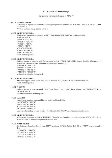
5.3.- NAVAREA TWO WarningsNavigational warnings in force on 11 MAY 09007/09 POINTE NOIREAnchoring of eight white cylindrical mooring buoys in area boun<strong>de</strong>d by: 5º59,50´S / 6º01,61´S and 11º11,00´E/ 11º13,07´E.Caution and keep sharp lookout advised.030/09 GULF OF GUINEAUn<strong>de</strong>rwater operations in progress by M/V “BOURBOM PERIDOT” on area boun<strong>de</strong>d by:4º59´N 4º33,3´W4º58,9´N 4º27,5´W4º58,25´N 4º27,3´W4º58,25´N 4º24´W.4º52,6´N 4º24´W4º52,6´N 4º28,6´W.4º54,22´N 4º28,6´W4º54,2´N 4º33,6´W.Wi<strong>de</strong> berth requested.058/09 GULF OF GUINEASeismic survey in progress until further notice by S/V “GECO EMERALD” towing 8 cables 6500 meters inlength and 700 meters wi<strong>de</strong> behind the vessel in area boun<strong>de</strong>d by:4º42,198´N 2º16,622´W4º30,040´N 2º16,634´W4º30,003´N 1º48,405´W4º42,149´N 1º48,385´W.6.5 nautical miles berth requested.073/09 GULF OF GUINEAOffshore support vessel falcon crest sunk in position: 4º21,7´N 8º22,1´E at 271600Z MAR 09.Wi<strong>de</strong> berth requested.102/09 PAZENNSeismic survey in progress until 5 MAY and from 11 to 15 MAY in area between 47º50´N 48º35´N and10º50´W 9º45´W.Five nauticals miles berth requested.104/09 AGADIRA restricted area take place until further notice and boun<strong>de</strong>d by:A - 30º30,2´N 9º41,2´WB - 30º26,6´N 9º39,4´WC - 30º26,6´N 9º41,8´WD - 30º30,2´N 9º43,4´W.Any vessel intending to cross this area should contact the MOROCCAN maritimes authorities.105/09 GULF OF GUINEACable repair operation by C/S “CHAMAREL” from 04 MAY until further notice between 6º20´N 3º26,2´E and6º10´N 3º24,6´E. Submarine system rov will be used.106/09 CAPE VERDERocket space launching fallout hazard MAY exist due 2330Z to 0300Z daily 05 to 19 MAY in area boun<strong>de</strong>dby:19º06,48´N 35º34,42´W18º13,32´N 34º11,60´W17º11,23´N 34º58,34´W18º06,37´N 36º16,12´W.