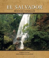
Río Lempa: Riqueza y Majestuosidad

Create successful ePaper yourself
Turn your PDF publications into a flip-book with our unique Google optimized e-Paper software.
HISTORIA ANCESTRAL<br />
ANCIENT HISTORY<br />
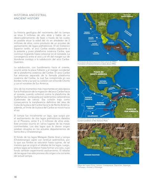
La historia geológica del nacimiento del río <strong>Lempa</strong><br />
se situa 5 millones de año atrás y habla de un<br />
desencadenamiento de fases a través de las cuales<br />
es posible situar la edad del río en alrededor de 2<br />
millones de años, como producto de un proceso de<br />
asolvamiento de lagos prehistóricos. El en Cretácico<br />
Superior tardío, el arco Caribe estaba adyacente a<br />
la potente y joven plataforma oceánica Caribe, que<br />
continuó migrando hasta colisionar en el noroeste. La<br />
convergencia entre el arco y el rift del margen sur de<br />
Honduras condujo a la subducción del arco Caribe-<br />
Guerrero.<br />
La subducción, con hundimiento hacia el oriente,<br />
ocurrió entre la placa Fallarón y el margen occidental<br />
de la plataforma oceánica del Caribe. El arco Caribe<br />
fue entonces separado de la llamada plataforma<br />
oceánica del Caribe, la cual fue comprimida en sus<br />
bordes norte y sur por su colisión con el borde Chortis<br />
y con el noroeste de Sur América.<br />
Uno de los momentos más importantes en esta época<br />
fue la finalización de la migración del arco Caribe hacia<br />
el noreste, cuando colisionó contra la plataforma de<br />
las Bahamas, compuesta por sedimentos carbonáticos<br />
(Carbonato de calcio). Esa colisión trajo como<br />
consecuencia la transferencia definitiva del área de<br />
Cuba de la placa del Caribe hacia la de Norte América;<br />
además, el límite de la placa del Caribe se movió hacia<br />
el sur.<br />
El <strong>Lempa</strong> fue inicialmente un lago, que surgió por<br />
el asolvamiento de dos lagos prehistóricos datados<br />
en el Plioceno, entre 5 y 3 millones de años atrás.<br />
Este proceso ocurría en varios lugares de las masas<br />
continentales. Los dos lagos que le dieron origen<br />
estaban situados en los actuales departamentos de<br />
Santa Ana y Chalatenango.<br />
El fondo de los lagos Metapán (Santa Ana) y <strong>Lempa</strong><br />
(Chalatenango) captó con lentitud sedimentos, por<br />
lo que sus fondos se saturaron hasta tupirse, de tal<br />
manera que se originó el rebalse de los lagos. Luego,<br />
ambos lagos se fundieron hasta formar uno solo, cuyo<br />
fondo también experimentó asolvamiento. El rebalse<br />
de las aguas tras este proceso dio origen a la corriente<br />
del actual <strong>Lempa</strong>.<br />
Formación de Centroamérica hace cerca de 49Ma.<br />
Formation of Central America makes about 49Ma.<br />
Condición actual de la placa tectónica.<br />
Current condition of the Tectonic Plate.<br />
Mapa de Lagos Güija, <strong>Lempa</strong>, Coatepeque, Zapotitán, Ilopango,<br />
Titihuapa, Jocotal y Olomega.<br />
The geological history of <strong>Lempa</strong>’s origin begins<br />
5 million years ago and speaks about unleashing<br />
phases through which it is possible to locate the age<br />
of the river over about 2 million of years, as a product<br />
of the process of siltation of the prehistoric lakes. In<br />
the Late Cretaceous, the Caribbean Arc was adjacent<br />
to the powerful and young Caribbean Oceanic Plate,<br />
which continued to migrate until it would collide in<br />
the northeast. The convergence between the arc and<br />
the rift border of the south of Honduras led to the<br />
subduction of the Guerrero-Caribbean Arc.<br />
The subduction, sinking towards the east, happened<br />
between Fallaron Plate and the east border of<br />
the Caribbean Oceanic Plate. The Caribbean Arc<br />
separated from the Caribbean Oceanic Plate, and was<br />
compressed in its northern and southern borders by<br />
its collision with the Chortis border and the northeast<br />
of South America.<br />
One of the most important moments of the time<br />
was the completion of the movement towards the<br />
northeast of the Caribbean Arc; when it collided<br />
Cultura <strong>Lempa</strong>. Vaso con la representación de un<br />
rostro humano en altorrelieve. Encontrado en el<br />
departamento de Usulután. Período preclásico.<br />
Culture <strong>Lempa</strong> River. Vessel with a human face in<br />
high relief. Found in Usulután. Pre Classic Period.<br />
CAUSE CULTURAL<br />
CULTURAL FLOW<br />
against the Bahamas Plate composed by carbonate<br />
sediments.<br />
This collision brought as a consequence the definite<br />
transfer of Cuba´s area from the Caribbean Plate which<br />
was going to the North American one. Still, the limit of<br />
the Caribbean Plate moved to the south.<br />
<strong>Lempa</strong> was initially a lake, which emerged by the siltation<br />
of two prehistoric lakes in the Plioceno, between 5<br />
and 3 million years ago. This process ocurred in some<br />
places along the continental masses. The two lakes<br />
which gave origin were located in the city of Santa Ana,<br />
and Chalatenango.<br />
The bottom of the two lakes; Matapán (Santa Ana) and<br />
<strong>Lempa</strong> (Chalatenango), slowly captured the sediments<br />
and their bottoms got satured up until they overflow.<br />
Then, both lakes joined one another until only one body<br />
of water was seen, and its bottom also experienced<br />
siltation. The next overflow gave the beginning for<br />
actual <strong>Lempa</strong> riverbed.<br />
La mayoría de las poblaciones más antiguas registradas<br />
hasta ahora por la arqueología se asentaron alrededor<br />
del <strong>Lempa</strong>, desde las nahuapipiles, las lencas y<br />
posteriormente las españolas en el proceso de<br />
colonización del territorio. Precisamente porque el río<br />
significaba subsistencia pero también comunicación<br />
e intercambios comerciales. Los sitios arqueológicos<br />
prehispánicos de Cihuatán, San Andrés, Tazumal, Joya<br />
de Cerén, San Marcos <strong>Lempa</strong> y la colonial Ciudad vieja<br />
confirman precisamente la importancia del río para el<br />
desarrollo de las comunidades. Los grupos pipiles, una<br />
rama de los grupos nahuas que poblaron los actuales<br />
territorios de México y Guatemala, consideraban al río<br />
también como un elemento sagrado que los mantenía<br />
en comunicación con el dios del agua representado por<br />
Tlaloc.<br />
The mayority of the most ancient population registered<br />
up until now data by arqueology; were settled nearby<br />
<strong>Lempa</strong>. Starting from Nahuapipiles, Lencas, and<br />
moreover the Spanish in the process of colonizing<br />
the territory. Because the river meant subsistence,<br />
communication, and trade, the archeological sites of<br />
Cihuatán, San Andrés, Tazumal, Joya de Cerén, San<br />
Marcos <strong>Lempa</strong>, and Ciudad Vieja, were the first five<br />
to be founded in the Prehispanic Period and Spanish<br />
Colonization. This confirms the importance of the river<br />
for developing communities. The group of the Pipiles,<br />
a branch of the Nahuas which settled in the actual<br />
territories of Mexico and Guatemala, considerated the<br />
river as a sacred element which would keep them in<br />
communication with Tlaloc, God of Water.<br />
18 19