Harteveld Rare Books Ltd. Fribourg, Switzerland
Harteveld Rare Books Ltd. Fribourg, Switzerland
Harteveld Rare Books Ltd. Fribourg, Switzerland

Create successful ePaper yourself
Turn your PDF publications into a flip-book with our unique Google optimized e-Paper software.
73 <strong>Harteveld</strong> <strong>Rare</strong> <strong>Books</strong> <strong>Ltd</strong>., CH-1700 <strong>Fribourg</strong><br />
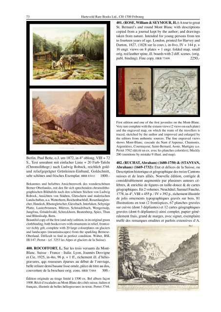
401. (ROSE, William & SEYMOUR, H.:) A tour to great<br />
St. Bernard’s and round Mont Blanc with descriptions<br />
copied from a journal kept by the author; and drawings<br />
taken from nature. Intended for young persons from ten<br />
to fourteen years of age. London, printed for Harvey and<br />
Darton, 1827, (1828 sur la couv.), in-8vo, IV + 144 p. +<br />
16 engr. views on 8 plates + 1 engr. folded map, small<br />
orig. red leather spine, ill. boards with 2 diff. scenes. (orig.<br />
publ. binding). Fine copy. HRB 77499 2250.-<br />
Berlin, Paul Bette, o.J. um 1872, in-4° oblong, VIII + 72<br />
S., Text umrahmt mit einfacher Linie + 20 Farb-Tafeln<br />
(Chromolithogr.) nach Ludwig Robock, reichlich gold-<br />
und reliefgeprägter Grünleinen-Einband, Goldschnitt,<br />
sehr schönes und frisches Exemplar. HRB 83411 1800.-<br />
Bekanntes und beliebtes Ansichtenwerk des wunderschönen<br />
Berner Oberlandes, mit den für sich sprechenden chromolithographischen<br />
Bildtafeln nach den schönen Stichen von Ludwig<br />
Robock, Ansichten von Städten, Gletschern und malerischen<br />
Landschaften, u.a. Wetterhorn, Reichenbachfall, Rosenlauigletscher,<br />
Handeck, Rhonegletscher, Giessbach, Interlaken, Schynige<br />
Platte, Lauterbrunnen, Mürren, Schmadribach, Wengernalp,<br />
Jungfrau, Grindelwald, Schreckhorn, Beatenberg, Spiez, Thun<br />
und Blümlisalp, Bern.<br />
Beautiful copy of the first (and only) edition, in its original green<br />
clothbinding, both bookcovers with ornaments in relief, frontcover<br />
richly gilt, complete with 20 large colourplates on glaciers<br />
and landscapes (mountainscapes) from the sparkling Bernese-<br />
Oberland. Difficult to find in perfect condition. Wäber, BSL<br />
III/147; Perret - (cf. 3253 les Alpes et glaciers de la Suisse).<br />
400. ROCOFFORT, L. Sur les trois versants du Mont-<br />
Blanc. Suisse - France - Italie. Lyon, Joannès Desvigne<br />
et Cie, 1925, in-4to, 96 p. + 1 ff., richement ill. d’héliogravures,<br />
qqs rousseurs éparses au début de l’ouvrage,<br />
belle reliure demi basane lisse ornée, pièce de titre au dos,<br />
couverture de la brochure orig. cons. HRB 73484 300.-<br />
Édition originale au tirage limité à 1500 ex. Bel album façon<br />
1900. Récit d’escalades au Mont-Blanc des côtés suisse, italien et<br />
français, illustrée de belles héliogravures in-texte. Perret 3744.<br />
First edition and one of the first juveniles on the Mont-Blanc.<br />
Very rare complete with the sixteen views (2 views on each plate)<br />
and the engraved map, on which the route of the travellers is<br />
traced, sketched by the author and improved and enlarged by<br />
the editors from authentic sources. The fine engraved views<br />
shows Mont-Blanc, cascade du Nant d’Arpenaz, Chamonix,<br />
Argentières, Courmayeur, Saint-Bernard, Aoste, Martigny a.o.<br />
Perret 3762 (décrit un ex. avec les planches coloriées); Meckly<br />
200 (mentions by mistake 9 illust. and map).<br />
402. (RUCHAT, Abraham) (1680-1750) & (STANYAN,<br />
Abraham) (1669-1732): Etat et délices de la Suisse, ou<br />
Description historique et géographique des treize Cantons<br />
suisses et de leurs alliés. Nouvelle édition, corrigée &<br />
considérablement augmentée par plusieurs auteurs célèbres,<br />
& enrichie de figures en taille-douce & de cartes<br />
géographiques. En 2 volumes. Neuchâtel, Samuel Fauche,<br />
1778, in-4°, VIII + 455 p. / IV + 392 p., richement illustrée<br />
de jolis ornements typographiques gravés sur bois, 81<br />
illustrations en tout (2 frontispices, 67 planches gravées<br />
sur cuivre (dont 3 dépliantes) et 12 cartes géographiques<br />
gravées (dont 6 dépliantes)) ainsi complet, papier généralement<br />
frais, grand de marges, avec signet, exemplaire<br />
truffé des remarques erudites et parfois extensives d‘A.