pdf 1 - exhibitions international
pdf 1 - exhibitions international
pdf 1 - exhibitions international

You also want an ePaper? Increase the reach of your titles
YUMPU automatically turns print PDFs into web optimized ePapers that Google loves.
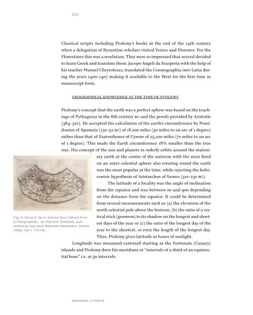
Fig. 2: Soria E Terra Sancta Nova Tabvla from<br />
La Geographia... by Giacomo Gastaldi, published<br />
by Giovanni Battista Pedrezano, Venice<br />
1548; 130 x 170 mm<br />
[24] [25]<br />
Classical scripts including Ptolemy’s books at the end of the 14th century<br />
when a delegation of Byzantine scholars visited Venice and Florence. For the<br />
Florentines this was a revelation. They were so impressed that several decided<br />
to learn Greek and translate them. Jacopo Angeli da Scarperia with the help of<br />
his teacher Manuel Chrysoloras, translated the Cosmographia into Latin during<br />
the years 1400–1407 making it available to the West for the first time in<br />
manuscript form.<br />
GeoGrAphicAl knowledGe At the time of ptolemy<br />
Ptolemy’s concept that the earth was a perfect sphere was based on the teachings<br />
of Pythagoras in the 6th century Bc and the proofs provided by Aristotle<br />
(384–322). He accepted the calculation of the earth’s circumference by Poseidonius<br />
of Apameia (130–52 Bc) of 18,000 miles (50 miles to an arc of 1 degree)<br />
rather than that of Eratosthenes of Cyrene of 25,200 miles (70 miles to an arc<br />
of 1 degree). This made the Earth circumference 18% smaller than the true<br />
size. His concept of the sun and planets in orderly orbits around the stationary<br />
earth at the centre of the universe with the stars fixed<br />
on an outer celestial sphere also rotating round the earth<br />
was the most popular at the time, while rejecting the heliocentric<br />
hypothesis of Aristarchus of Samos (310–230 Bc).<br />
The latitude of a locality was the angle of inclination<br />
from the equator and was between 00 and 900 depending<br />
on the distance from the equator. It could be determined<br />
from several measurements such as (a) the elevation of the<br />
north celestial pole above the horizon, (b) the ratio of a vertical<br />
stick (gnomon) to its shadow on the longest and shortest<br />
days of the year or (c) the ratio of the longest day of the<br />
year to the shortest, or even the length of the longest day.<br />
Thus, Ptolemy gives latitude as hours of sunlight.<br />
Longitude was measured eastward starting at the Fortunate (Canary)<br />
islands and Ptolemy drew his meridians at “intervals of a third of an equinoctial<br />
hour” i.e. at 50 intervals.<br />
“The Zodiacal circle”, the ecliptic, was recognised as the circle tilted at<br />
an angle of 240 traversed by the sun at a rate of just under a degree a day opposite<br />
to the rotation of the stars. The most northerly point of the ecliptic defined<br />
the Tropic of Cancer and the most southerly the Tropic of Capricorn.<br />
Tow further circles were recognised, the Arctic and Antarctic where the<br />
longest day of the year just reached 24 hours.<br />
Although the division of the circle to 3600 dates to Babylonian times<br />
and was used by the Greek astronomers and mathematicians,<br />
Ptolemy was the first to apply it in the use of terrestrial coordinates<br />
for specifying geographic positions.<br />
The habitable world of Ptolemy, the oikoumene, occupied<br />
one quarter of the earth, from just south of the equator to the<br />
64½ degrees north of the equator, and from the fortunate islands<br />
00 longitude to the end of the “Silk country” 1800 longitude.<br />
Thus, the width of Europe and Asia were exaggerated by 30%.<br />
Ptolemy believed that there was a southern land counterbalancing<br />
the land north of the equator so that the Indian Ocean was<br />
shown as a closed sea, but this land south of the equator was too<br />
hot to sustain human life. On the question whether the land on<br />
the other side of the earth was inhabited Ptolemy kept an open mind. The<br />
oikoumene was divided in three continents, Europe, Libye (Africa) and Asia.<br />
In the Geographia, Ptolemy states that to draw the world map on a globe<br />
is a method of ensuring correct representation of distances, but argues that<br />
globes are usually too small to show detail and he describes how to make<br />
projections on a flat surface. He gives detailed instructions how to make three<br />
different projections. His first projection is a conical one. In this projection<br />
east-west distances are portrayed in correct proportionality to north-south<br />
distances only along the parallel of Rhodes. His second projection is a pseudoconical<br />
one that preserves the ratio of the total latitudinal dimension to the<br />
total longitudinal dimension for all parallels. A third spherical projection is a<br />
modification of the second, but has not been used in any of the manuscript or<br />
printed Ptolemaic atlases. In addition to the world map, Ptolemaic atlases<br />
contain 26 regional maps with equidistant meridians and parallels: 10 for<br />
MAPPING CYPRUS EUROPEAN CARTOGRAPHERS AND CYPRUS<br />
Fig. 3: Asiae IIII Tab: From Tabvlae Goographicae<br />
Cl. Ptolomei... edited by Gerard<br />
Mercator, and printed by Godefrid von<br />
Kempen, Cologne, 1578; 345 x 465 mm


![01 -[BE/INT-2] 2 KOL +UITGEV+ - exhibitions international](https://img.yumpu.com/19621858/1/184x260/01-be-int-2-2-kol-uitgev-exhibitions-international.jpg?quality=85)