Cartes et plans, photographies aériennes - Ecole Nationale ...
Cartes et plans, photographies aériennes - Ecole Nationale ...
Cartes et plans, photographies aériennes - Ecole Nationale ...

Create successful ePaper yourself
Turn your PDF publications into a flip-book with our unique Google optimized e-Paper software.
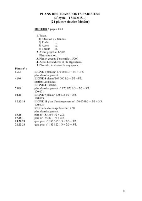
PLANS DES TRANSPORTS PARISIENS<br />
(3 e cycle - TSIOMIS...)<br />
(24 <strong>plans</strong> + dossier Météor)<br />
METEOR 6 pages. C4.I<br />
1. Texte.<br />
1) Situation x 2 feuilles.<br />
2) Trafic ;;;;.<br />
3) Accès ;;;;.<br />
4) Locaux ;;;;.<br />
2. Avant proj<strong>et</strong> au 1/500 e .<br />
Plans situation.<br />
3. Plan <strong>et</strong> coupes d'ensemble 1/500 e .<br />
4. Accès Lavandières <strong>et</strong> Ste Opportune.<br />
5. Plans de circulation de voyageurs.<br />
Plans n° :<br />
1.2.3 LIGNE 1 <strong>plans</strong> n° 170 0691/3 + 2/3 + 3/3.<br />
plan d'aménagement.<br />
4.5.6 LIGNE 4 plan n°169 000 1/3 + 2/3 +3/3.<br />
Station Les Halles.<br />
LIGNE 4 Châtel<strong>et</strong>.<br />
7.8.9 plan d'aménagement n° 170 070 1/3 + 2/3 + 3/3.<br />
170 071.<br />
10.11 LIGNE 7 plan n° 170 072 1/2 + 2/2.<br />
170 073.<br />
12.13.14 LIGNE 11 plan d'aménagement n° 170 0741/3 + 2/3 + 3/3.<br />
170 075.<br />
RER salle d'échange Niveau 17.60.<br />
plan d'aménagement.<br />
15.16 plan n° 183 364 1/2 + 2/2.<br />
17.18 plan n° 185 821 1/2 + 2/2.<br />
19.20.21 quai plan n° 183 365 1/3 + 2/3 + 3/3.<br />
22.23.24 quai plan n° 183 822 1/3 + 2/3 + 3/3.<br />
18