

atlas forestier interactif du congo - World Resources Institute
atlas forestier interactif du congo - World Resources Institute
atlas forestier interactif du congo - World Resources Institute

Create successful ePaper yourself
Turn your PDF publications into a flip-book with our unique Google optimized e-Paper software.
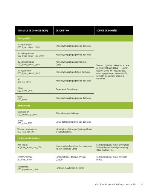
ENSEMBLE DE DONNÉES (nom) DESCRIPTION SOURCE DE DONNÉES<br />
Hydrographie<br />
Rivière principale<br />
CGO_hydro_niveau1_2010<br />
Réseau hydrographique principal <strong>du</strong> Congo<br />
Iles rivière principale<br />
CGO_hydro_niveau1_iles_2010<br />
Rivières secondaires<br />
CGO_hydro_niveau2_2010<br />
Rivières tertiaires<br />
CGO_hydro_niveau3_2010<br />
Iles<br />
CGO_iles_2010<br />
Fleuve<br />
CGO_fleuve_2010<br />
Réseau hydrographique principal <strong>du</strong> Congo<br />
Réseau hydrographique secondaire <strong>du</strong><br />
Congo<br />
Réseau hydrographique tertiaire <strong>du</strong> Congo<br />
Réseau hydrographique principal <strong>du</strong> Congo<br />
Empreinte <strong>du</strong> fleuve Congo<br />
Données originales, créées dans le cadre<br />
<strong>du</strong> projet OIBT (WRI-CNIAF) — numérisées<br />
sur la base des images Landsat,<br />
cartes topographiques nationales (IGN,<br />
CERGEC) et documents officiels de<br />
classement<br />
Océan<br />
CGO_ocean<br />
Réseau hydrographique principal <strong>du</strong> Congo<br />
Infrastructure<br />
Chemin de fer<br />
CGO_chemin_fer_2010<br />
Réseau ferroviaire <strong>du</strong> Congo<br />
Usines<br />
CGO_usine_2010<br />
Voies de communication<br />
CGO_voie_com_2011<br />
Usines de transformation de bois <strong>du</strong> Congo<br />
Infrastructures de transport (routes publiques<br />
et routes forestières)<br />
Limites administratives<br />
Pays voisins<br />
AC_limite_admin_sans_CGO<br />
Couche vectorielle appliquant un masque sur<br />
les pays voisins <strong>du</strong> Congo<br />
Carte numérique <strong>du</strong> monde provenant de<br />
National Geospatial-Intelligence Agency<br />
(NGA) des États-Unis<br />
Frontière nationale<br />
AC_limite_admin<br />
Limites nationales des pays d’Afrique<br />
Centrale<br />
Carte numérique <strong>du</strong> monde provenant<br />
de NGA<br />
Départements<br />
CGO_departement_2010<br />
Limite des départements <strong>du</strong> Congo<br />
Atlas Forestier Interactif <strong>du</strong> Congo - Version 3.0<br />
51


