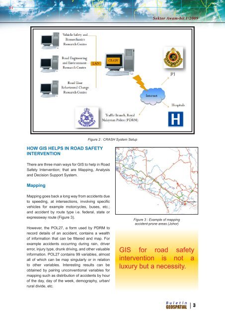
<strong>Sektor</strong> <strong>Awam</strong>-bil.1/<strong>2009</strong>DATABASE CONTENTCRASH - Centralised System for Road Accident,Safety and Hazard Studies - contains accidentdata, road network, road furniture, land andadministrative activities, and injury or epidemiologydata from hospitals.Accident data are such as vehicle type, driverdemographics, passengers involved, roadcondition, weather condition, etc. Road networkcomprises various levels of roads throughout<strong>Malaysia</strong>. Road furniture are such as kilometerpost, guardrails, traffic lights, etc. Examples of landand administrative activities are location of RoadSafety Education schools, hospitals, location ofIPD and IPK, and land use. Injury or epidemiologydata from hospitals are yet to be determined in itssystem and up to what extent (Figure 1).Objectives of CRASHIt is a national-level accident and injury databasewhereby it should comprise nationwide data ofroad network, accidents and injury. It also keepsa spatial record of road accidents in <strong>Malaysia</strong>and the corresponding injuries sustained beyondplain statistics. Currently both accident and injurydata are quite “divorced” from the spatial sensetherefore CRASH aims to enjoin both these typesand be able to further research on real-worldaccident distribution. When it is spatially linked,mapping and spatial analysis comesinto being as another important factorin its design and development. CRASHis to be as user-friendly as possible byhaving access using LAN and Web.2Accident DataInjuryRoad Furniture<strong>Buletin</strong>GEOSPATIALFigure 1 :Types of dataavailable inCRASH databaseRoad NetworkLand andAdministrativeAt this initial stage, CRASH isdeveloped mainly for MIROSresearchers and officers. It is alsodeveloped for traffic enforcementagencies such as PDRM and JPJ.These agencies are the main datasources therefore CRASH returns thesupport by helping them do their dutiesbetter through analyses and basing onscientific findings. CRASH is also developedfor affiliated external organizations suchas Ministry of Transport (MOT), GlobalRoad Safety Partnership (GRSP), JabatanKeselamatan Jalan Raya (JKJR), RoadTraffic Injuries Research Network (RTIRN)and International Road Assessment Programme(iRAP) because in Road Safety should not workin isolation.CRASH System SetupThe CRASH system comprises of a system serveron which all data are compiled. It is connectedto three other Centre servers that contain datafrom respective MIROS Research departmentsvia Local Area Network. The CRASH system isconnected to PDRM, JPJ and Hospitals via theinternet, although currently the only system thatwe are connected to is the PDRM. We are still inplanning stage with the others (Figure 2).
<strong>Sektor</strong> <strong>Awam</strong>-bil.1/<strong>2009</strong>HOW GIS HELPS IN ROAD SAFETYINTERVENTIONThere are three main ways for GIS to help in RoadSafety Intervention; that are Mapping, Analysisand Decision Support System.MappingFigure 2 : CRASH System SetupMapping goes back a long way from accidents dueto speeding, at intersections, involving specificvehicles for example motorcycles, buses, etc.;and accident by route type i.e. federal, state orexpressway route (Figure 3).However, the POL27, a form used by PDRM torecord details of an accident, contains a wealthof information that can be filtered and map. Forexample accidents occurring during rain, drivererror, injury type, drunk driving, and other valuableinformation. POL27 contains 99 variables, almostall of which can be map singularly or in relationto other variables. Interesting results can beobtained by pairing unconventional variables formapping such as distribution of accidents by hourof the day, day of the week, demography, urban/rural divide, etc.Figure 3 : Example of mappingaccident-prone areas (Johor)GIS for road safetyintervention is not aluxury but a necessity.<strong>Buletin</strong>GEOSPATIAL 3