A6 - Relazione agroforestale e ambientale - Comune di Sarroch
A6 - Relazione agroforestale e ambientale - Comune di Sarroch
A6 - Relazione agroforestale e ambientale - Comune di Sarroch

You also want an ePaper? Increase the reach of your titles
YUMPU automatically turns print PDFs into web optimized ePapers that Google loves.
COMUNE DI SARROCH - Provincia <strong>di</strong> Cagliari<br />
Piano Urbanistico Comunale in adeguamento al PPR<br />
STUDIO AGROFORESTALE, AMBIENTALE E TERRITORIALE<br />
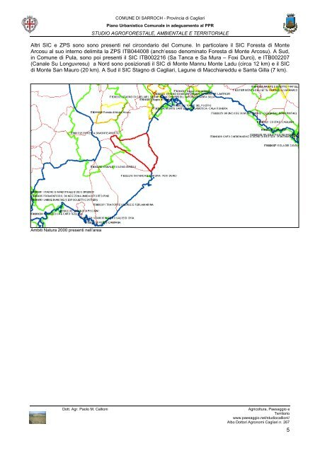
Altri SIC e ZPS sono sono presenti nel circondario del <strong>Comune</strong>. In particolare il SIC Foresta <strong>di</strong> Monte<br />
Arcosu al suo interno delimita la ZPS ITB044008 (anch’esso denominato Foresta <strong>di</strong> Monte Arcosu). A Sud,<br />
in <strong>Comune</strong> <strong>di</strong> Pula, sono poi presenti il SIC ITB002216 (Sa Tanca e Sa Mura – Foxi Durci), e ITB002207<br />
(Canale Su Longuvresu) a Nord sono posizionati il SIC <strong>di</strong> Monte Mannu Monte Ladu (circa 12 km) e il SIC<br />
<strong>di</strong> Monte San Mauro (20 km). A Sud il SIC Stagno <strong>di</strong> Cagliari, Lagune <strong>di</strong> Macchiareddu e Santa Gilla (7 km).<br />
Ambiti Natura 2000 presenti nell’area<br />
Dott. Agr. Paolo M. Callioni Agricoltura, Paesaggio e<br />
Territorio<br />
www.paesaggio.net/stu<strong>di</strong>ocallioni/<br />
Albo Dottori Agronomi Cagliari n. 267<br />
5