Quantum GIS - Osgeo Download Server
Quantum GIS - Osgeo Download Server
Quantum GIS - Osgeo Download Server

You also want an ePaper? Increase the reach of your titles
YUMPU automatically turns print PDFs into web optimized ePapers that Google loves.
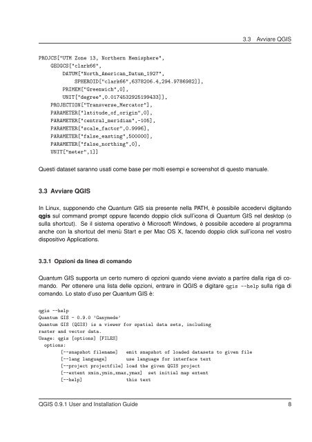
PROJCS["UTM Zone 13, Northern Hemisphere",<br />
GEOGCS["clark66",<br />
DATUM["North_American_Datum_1927",<br />
SPHEROID["clark66",6378206.4,294.9786982]],<br />
PRIMEM["Greenwich",0],<br />
UNIT["degree",0.0174532925199433]],<br />
PROJECTION["Transverse_Mercator"],<br />
PARAMETER["latitude_of_origin",0],<br />
PARAMETER["central_meridian",-105],<br />
PARAMETER["scale_factor",0.9996],<br />
PARAMETER["false_easting",500000],<br />
PARAMETER["false_northing",0],<br />
UNIT["meter",1]]<br />
3.3 Avviare Q<strong>GIS</strong><br />
Questi dataset saranno usati come base per molti esempi e screenshot di questo manuale.<br />
3.3 Avviare Q<strong>GIS</strong><br />
In Linux, supponendo che <strong>Quantum</strong> <strong>GIS</strong> sia presente nella PATH, è possibile accedervi digitando<br />
qgis sul command prompt oppure facendo doppio click sull’icona di <strong>Quantum</strong> <strong>GIS</strong> nel desktop (o<br />
sulla shortcut). Se il sistema operativo è Microsoft Windows, è possibile accedere al programma<br />
anche con la shortcut del menù Start e per Mac OS X, facendo doppio click sull’icona nel vostro<br />
dispositivo Applications.<br />
3.3.1 Opzioni da linea di comando<br />
<strong>Quantum</strong> <strong>GIS</strong> supporta un certo numero di opzioni quando viene avviato a partire dalla riga di comando.<br />
Per ottenere una lista delle opzioni, entrare in Q<strong>GIS</strong> e digitare qgis --help sulla riga di<br />
comando. Lo stato d’uso per <strong>Quantum</strong> <strong>GIS</strong> è:<br />
qgis --help<br />
<strong>Quantum</strong> <strong>GIS</strong> - 0.9.0 ’Ganymede’<br />
<strong>Quantum</strong> <strong>GIS</strong> (Q<strong>GIS</strong>) is a viewer for spatial data sets, including<br />
raster and vector data.<br />
Usage: qgis [options] [FILES]<br />
options:<br />
[--snapshot filename] emit snapshot of loaded datasets to given file<br />
[--lang language] use language for interface text<br />
[--project projectfile] load the given Q<strong>GIS</strong> project<br />
[--extent xmin,ymin,xmax,ymax] set initial map extent<br />
[--help] this text<br />
Q<strong>GIS</strong> 0.9.1 User and Installation Guide 8