- Page 4 and 5: SORIN ŞTEFĂNUŢThe Hornwort and L
- Page 6: CONTENTINTRODUCTION ...............
- Page 11 and 12: The beginning of the 20 th century
- Page 13 and 14: asin of the Arieş river. Bryotaxon
- Page 15 and 16: Abbreviations used in the text† -
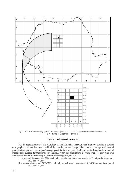
- Page 17: The presentation of the methodology
- Page 21 and 22: THE HORNWORT AND LIVERWORT SPECIES
- Page 23 and 24: THE HORNWORT AND LIVERWORT CLASSIFI
- Page 25 and 26: Suborder Lepidoziineae R.M. Schust.
- Page 27 and 28: 46. Cephalozia pleniceps (Austin) L
- Page 29 and 30: 147. Pallavicinia lyellii (Hook.) C
- Page 31 and 32: 13 Corsinia coriandrina (Spreng.) L
- Page 33 and 34: 11. Porella obtusata (Taylor) Trevi
- Page 35 and 36: 34Phaeoceros carolinianus (Michx.)
- Page 37 and 38: Făgăraş Mountains, Cârţişoara
- Page 39 and 40: Cluj County, Someşul Rece Valley a
- Page 41 and 42: Parâng Mountains, Repedea Valley,
- Page 43 and 44: Argeş County, Rucăr (Loitlesberge
- Page 45 and 46: Cindrel Mountains, Cindrel, 2200 m
- Page 47 and 48: Parâng Mountains, Latoriţa Valley
- Page 49 and 50: Athalamia hyalina (Sommerf.) S. Hat
- Page 51 and 52: Barbilophozia barbata (Schmidel ex
- Page 53 and 54: Bârgău Mountains, Cârţibavu Mar
- Page 55 and 56: First citation for Romania: Schur 1
- Page 57 and 58: - Pleuroschisma triangulare (Schlei
- Page 59 and 60: and Băiuţ, common spruce forest,
- Page 61 and 62: Distribution in Europe: Sj, Is, Fo,
- Page 63 and 64: Poiana Stampei Peatbog, SV, 47°20'
- Page 65 and 66: alt., 8.08.2003, leg. Pop O., det.
- Page 67 and 68: leg. & det. Ştefureac T., ass. Buc
- Page 69 and 70:
Rodna Mountains, Puzdra Mountain, 1
- Page 71 and 72:
Alba County, Vârciorog Valley, 780
- Page 73 and 74:
Bârgău Mountains, Cucureasa Reser
- Page 75 and 76:
Suceava County, Tinovul Mare de la
- Page 77 and 78:
Suceava County, Rodna Nouă, on Per
- Page 79 and 80:
2001:74,75); Arieşul Mare Basin, o
- Page 81 and 82:
Ţibleş Mountains, Mesteacănul Va
- Page 83 and 84:
Cindrel Mountains, Găuşoara, leg.
- Page 85 and 86:
Parâng Mountains, the edge of Câl
- Page 87 and 88:
& det. Ştefănuţ S. [BUCA B3684];
- Page 89 and 90:
Alba County, at 20,5 km to Zlatna,
- Page 91 and 92:
Cephaloziella spinigera (Lindb.) Wa
- Page 93 and 94:
First citation for Romania: Péterf
- Page 95 and 96:
Iezer-Păpuşa Mountains, Iezer Val
- Page 97 and 98:
- Cladopodiella fluitans var. gigan
- Page 99 and 100:
Caraş-Severin County, Cerna Valley
- Page 101 and 102:
(Mititelu, Barabaş N. & al. 1968:1
- Page 103 and 104:
1885:30; Ştefureac 1949a:287,288;
- Page 105 and 106:
104Conocephalum salebrosum Szweyk.,
- Page 107 and 108:
Retezat Mountains, Retezat, sub Jun
- Page 109 and 110:
Cindrel Mountains, Cânaia, 1750 m
- Page 111 and 112:
Iaşi County, Sineşti Forest (Papp
- Page 113 and 114:
[BUCA B2793], on rotten beech trunk
- Page 115 and 116:
Orthodicrano montani-Hypnetum filif
- Page 117 and 118:
Distribution in Romania:Maramureş
- Page 119 and 120:
- Gymnocolea inflata var. laxa (Nee
- Page 121 and 122:
Ciucaş Mountains, Caprei Brook Val
- Page 123 and 124:
Giumalău Mountain, Giumalău Secul
- Page 125 and 126:
- Haplozia riparia var. rivularis B
- Page 127 and 128:
- Jungermannia karl-muelleri auct.,
- Page 129 and 130:
Jungermannia gracillima Sm.Syn.:- A
- Page 131 and 132:
Mountain, PH, 45°24'40"N / 25°28'
- Page 133 and 134:
Retezat Mountains, Rovine Brook, on
- Page 135 and 136:
Romania, alt. 600-2280 m (Váňa 19
- Page 137 and 138:
- Solenostoma subellipticum (Lindb.
- Page 139 and 140:
Distribution in Romania:Bârgău Mo
- Page 141 and 142:
13.07.1946, sub Lophozia alpestris
- Page 143 and 144:
Distribution in Romania:Maramureş
- Page 145 and 146:
Rodna Mountains, Lala Valley, 1200
- Page 147 and 148:
Ştefănuţ S. [BUCA B2574, B2580,
- Page 149 and 150:
Dealul Colbului and Pietrele Doamne
- Page 151 and 152:
150var. rivularis (Raddi) Warnst.Sy
- Page 153 and 154:
Penteleu Massif, fer - Roşu Lake,
- Page 155 and 156:
Satu Mare County, Noroieni, Ghiarma
- Page 157 and 158:
Lophozia ascendens (Warnst.) R.M. S
- Page 159 and 160:
- Jungermannia intermedia Lindenb.-
- Page 161 and 162:
Căliman Mountains, on humus and ro
- Page 163 and 164:
Hăşmaş Mountains, Hăşmaş, sub
- Page 165 and 166:
Herbaria and Exsiccate: BUCADistrib
- Page 167 and 168:
peatbog on the border of Câlcescu
- Page 169 and 170:
? - Iezer-Păpuşa Mountains, Iezer
- Page 171 and 172:
Făgăraş Mountains, s - above Avr
- Page 173 and 174:
Nemira Mountains, on edge of Nemira
- Page 175 and 176:
2003:7); Măgura Cisnădiei [SIB HL
- Page 177 and 178:
Fuss 1854:20; Ştefureac 1949a:288;
- Page 179 and 180:
- Nardia brevissima (Dumort.) Lindb
- Page 181 and 182:
1919:295); Ciortea Mountain, on wet
- Page 183 and 184:
- Sarcoscyphus sphacelatus var. med
- Page 185 and 186:
Siriu Mountain, Poiana din Fundul M
- Page 187 and 188:
Iaşi County, below Repedea, 7.10.1
- Page 189 and 190:
Valley, Arieşul Mic - upstream min
- Page 191 and 192:
Alba County, Valea Lungă, 10.02.18
- Page 193 and 194:
Rarău Massif, between Dealul Colbu
- Page 195 and 196:
Harghita County, Harghita Spa, on r
- Page 197 and 198:
Căliman Mountains, in alpine zone,
- Page 199 and 200:
Stânişoara Mountains, Suha Mare B
- Page 201 and 202:
Ecology: humicolous, acidophytic, h
- Page 203 and 204:
Bacău County, Slănic Brook (Papp
- Page 205 and 206:
Rarău Mountain, Codrul Secular Sl
- Page 207 and 208:
1915:197,198); Cândeşti, 07.1891,
- Page 209 and 210:
Ţibleş Mountains, Piciorul Ţigle
- Page 211 and 212:
Ceahlău Mountain, Durău Valley, i
- Page 213 and 214:
major (Ştefureac 1962b:69); Benea-
- Page 215 and 216:
Ciucaş Mountains, Berii Brook Vall
- Page 217 and 218:
Zlătuia Valley, 1100 m alt., 7.09.
- Page 219 and 220:
- Plagiochila dillenii (Taylor) Tay
- Page 221 and 222:
Wallfisch R. (Dihoru G. & al. 2003:
- Page 223 and 224:
Ştefănuţ M. 2003:79); Iezerul Pi
- Page 225 and 226:
utabuli-Mnietum cuspidati (Felföld
- Page 227 and 228:
Iaşi County, Mârzeşti Forest, Bu
- Page 229 and 230:
3.04.2004, leg. Atanasiu Paulina, d
- Page 231 and 232:
Arad County, Săvârşin, sub Madot
- Page 233 and 234:
Preissia quadrata (Scop.) NeesSyn.:
- Page 235 and 236:
Diana, BV, 1100 m alt., 22.08.2001,
- Page 237 and 238:
Rodna Mountains (Pax 1908:130); Pie
- Page 239 and 240:
Descut, 15.08.2001, Podul de Piatr
- Page 241 and 242:
Bârgău Mountains, Cucureasa Reser
- Page 243 and 244:
B3521, B3522] (Ştefănuţ 2006b:34
- Page 245 and 246:
16,20.08.1994, ass. Pterigynandretu
- Page 247 and 248:
- Marchantia crinita Michx.- Marcha
- Page 249 and 250:
Giumalău Mountain, Giumalău Secul
- Page 251 and 252:
Riccardia multifida (L.) GraySyn.:-
- Page 253 and 254:
Penteleu Massif, the left side of C
- Page 255 and 256:
Herbaria and Exsiccate: SIBDistribu
- Page 257 and 258:
558,560; Papp 1939a:358; Papp & Eft
- Page 259 and 260:
Riccia glauca L. var. glaucaSyn.:-
- Page 261 and 262:
Distribution in Europe: Is, Fo, No,
- Page 263 and 264:
Bihor County, Tărian, sub Riccia (
- Page 265 and 266:
1960:1113); upper side of Mălăie
- Page 267 and 268:
Scapania brevicaulis TaylorSyn.:- S
- Page 269 and 270:
Suceava County, Cristişor-Neagra B
- Page 271 and 272:
Piatra Mare Mountain, 1700 m alt.,
- Page 273 and 274:
- Scapania amurensis Warnst.- Scapa
- Page 275 and 276:
Mureş County, Sighişoara - Fuchsl
- Page 277 and 278:
Căliman Mountains, the peatbogs fr
- Page 279 and 280:
- Scapania heterophylla M. Howe- Sc
- Page 281 and 282:
Slăvei and Muchia Ascuţită, 2000
- Page 283 and 284:
Distribution in Europe: Ie, Br, Fr,
- Page 285 and 286:
Nemira Mountains, Nemira, on humus,
- Page 287 and 288:
- Sphenolobus medelpadicus (Arnell)
- Page 289 and 290:
Parâng Mountains, Latoriţa Valley
- Page 291 and 292:
Fig. 9. Distribution of Phaeoceros
- Page 293 and 294:
Fig. 13. Distribution of Anastrophy
- Page 295 and 296:
Fig. 17. Distribution of Anthelia j
- Page 297 and 298:
Fig. 21. Distribution of Asterella
- Page 299 and 300:
Fig. 25. Distribution of Barbilopho
- Page 301 and 302:
Fig. 29. Distribution of Barbilopho
- Page 303 and 304:
Fig. 33. Distribution of Bazzania t
- Page 305 and 306:
Fig. 37. Distribution of Calypogeia
- Page 307 and 308:
Fig. 41. Distribution of Calypogeia
- Page 309 and 310:
Fig. 45. Distribution of Cephalozia
- Page 311 and 312:
Fig. 49. Distribution of Cephalozia
- Page 313 and 314:
Fig. 53. Distribution of Cephalozie
- Page 315 and 316:
Fig. 57. Distribution of Cephalozie
- Page 317 and 318:
Fig. 61. Distribution of Cephalozie
- Page 319 and 320:
Fig. 65. Distribution of Cololejeun
- Page 321 and 322:
Fig. 69. Distribution of Corsinia c
- Page 323 and 324:
Fig. 73. Distribution of Fossombron
- Page 325 and 326:
Fig. 77. Distribution of Frullania
- Page 327 and 328:
Fig. 81. Distribution of Gymnocolea
- Page 329 and 330:
Fig. 85. Distribution of Harpanthus
- Page 331 and 332:
Fig. 89. Distribution of Jungermann
- Page 333 and 334:
Fig. 93. Distribution of Jungermann
- Page 335 and 336:
Fig. 97. Distribution of Jungermann
- Page 337 and 338:
Fig. 101. Distribution of Jungerman
- Page 339 and 340:
Fig. 105. Distribution of Leiocolea
- Page 341 and 342:
Fig. 109. Distribution of Lejeunea
- Page 343 and 344:
Fig. 113. Distribution of Lophocole
- Page 345 and 346:
Fig. 117. Distribution of Lophozia
- Page 347 and 348:
Fig. 121. Distribution of Lophozia
- Page 349 and 350:
Fig. 125. Distribution of Lunularia
- Page 351 and 352:
Fig. 129. Distribution of Marchanti
- Page 353 and 354:
Fig. 133. Distribution of Marsupell
- Page 355 and 356:
Fig. 137. Distribution of Marsupell
- Page 357 and 358:
Fig. 141. Distribution of Moerckia
- Page 359 and 360:
Fig. 145. Distribution of Nardia ge
- Page 361 and 362:
Fig. 149. Distribution of Odontosch
- Page 363 and 364:
Fig. 153. Distribution of Pedinophy
- Page 365 and 366:
Fig. 157. Distribution of Peltolepi
- Page 367 and 368:
Fig. 161. Distribution of Porella a
- Page 369 and 370:
Fig. 165. Distribution of Preissia
- Page 371 and 372:
Fig. 169. Distribution of Radula li
- Page 373 and 374:
Fig. 173. Distribution of Riccardia
- Page 375 and 376:
Fig. 177. Distribution of Riccia ca
- Page 377 and 378:
Fig. 181. Distribution of Riccia cr
- Page 379 and 380:
Fig. 185. Distribution of Riccia go
- Page 381 and 382:
Fig. 189. Distribution of Ricciocar
- Page 383 and 384:
Fig. 193. Distribution of Scapania
- Page 385 and 386:
Fig. 197. Distribution of Scapania
- Page 387 and 388:
Fig. 201. Distribution of Scapania
- Page 389 and 390:
Fig. 205. Distribution of Scapania
- Page 391 and 392:
Fig. 209. Distribution of Scapania
- Page 393 and 394:
Fig. 213. Distribution of Scapania
- Page 395 and 396:
Fig. 217. Distribution of Tritomari
- Page 397 and 398:
Evaluating the distribution dataFol
- Page 399 and 400:
Fig. 224. Hornworts and Liverworts
- Page 401 and 402:
Signs used:Bolded names - species i
- Page 403 and 404:
Marchantiaceae50. VU - Bucegia roma
- Page 405 and 406:
Fig. 228. The distribution of zones
- Page 407 and 408:
Anthoceros communis Steph. = Phaeoc
- Page 409 and 410:
Blasia funckii Corda = Blasia pusil
- Page 411 and 412:
Cephalozia crassiflora Spruce = Cep
- Page 413 and 414:
Cephaloziella spinigera (Lindb.) Wa
- Page 415 and 416:
Diplomitrium lyellii (Hook.) Corda
- Page 417 and 418:
Gymnocolea inflata subsp. acutiloba
- Page 419 and 420:
Jungermannia acuta var. gypsacea Go
- Page 421 and 422:
Jungermannia dentata Raddi = Cephal
- Page 423 and 424:
Jungermannia limprichtii Lindb. = L
- Page 425 and 426:
Jungermannia scalaris var. denudata
- Page 427 and 428:
Leiocolea heterocolpos (Thed. ex C.
- Page 429 and 430:
Lophozia incisa var. inermis Müll.
- Page 431 and 432:
Marchantia polymorpha var. dilatata
- Page 433 and 434:
Mastigobryum deflexum (Mart.) Ångs
- Page 435 and 436:
Odontoschisma sphagni var. denudatu
- Page 437 and 438:
Porella platyphylla (L.) Pfeiff.Por
- Page 439 and 440:
Riccia maior Roth = Riccia glauca L
- Page 441 and 442:
Scapania heterophylla M. Howe = Sca
- Page 443 and 444:
Sphagnocetis communis var. macrior
- Page 445 and 446:
Mittheilungen des siebenbürgischen
- Page 447 and 448:
91. Borza A., 1922a. Schedae ad "Fl
- Page 449 and 450:
142. Boşcaiu N., Täuber F., Colde
- Page 451 and 452:
199. Coldea G., 1975. Étude phytos
- Page 453 and 454:
256. Csűrös Ş., Moldovan I., Cs
- Page 455 and 456:
317. Dihoru G., 1987b. Contribuţie
- Page 457 and 458:
367. Domin K., 1923. Grundzüge der
- Page 459 and 460:
426. Gergely I., 1969. Pajişti mez
- Page 461 and 462:
487. Györffy I., 1906c. Polytrichu
- Page 463 and 464:
540. Györffy I., 1943b. Erdélyi P
- Page 465 and 466:
598. Ionescu Venera, Cristurean I.,
- Page 467 and 468:
658. Lungu Lucia, 1967a. Contribuţ
- Page 469 and 470:
712. Mihai G., 1971e. Aspecte ale b
- Page 471 and 472:
767. Mihăilescu Simona, Ştefănu
- Page 473 and 474:
824. Mohan G., 1988c. Die Gattung T
- Page 475 and 476:
879. Niţu I.T, 1973. Solurile cu e
- Page 477 and 478:
941. Papp C., 1931b. O schiţă a v
- Page 479 and 480:
999. Papp C., Eftimie Elena, 1963.
- Page 481 and 482:
1059. Péterfi L.Ş., 1963. Flagela
- Page 483 and 484:
1119. Plămadă, Viţalariu, 1971.
- Page 485 and 486:
1178. Pop I., Hodişan I., 1958. Co
- Page 487 and 488:
1231. Prunescu-Arion Elena, Toniuc
- Page 489 and 490:
1285. Raţiu O., 1970. Consideraţi
- Page 491 and 492:
1342. Rüegsegger F., 1986. Frullan
- Page 493 and 494:
1396. Schiffner V., 1913b. Über ei
- Page 495 and 496:
1455. Söderström L., Urmi E., Vá
- Page 497 and 498:
1515. Ştefănuţ S., 2004d. The Ho
- Page 499 and 500:
1567. Ştefureac T., 1960b. Cercet
- Page 501 and 502:
1624. Ştefureac T., 1976c. Rolul b
- Page 503 and 504:
1675. Ştefureac T., Cristurean I.,
- Page 505 and 506:
1727. Tarnavschi I., Nedelcu G., 19
- Page 507 and 508:
1785. Wallfisch R., 2008. Contribut
- Page 509 and 510:
var. fragilis (A. Roth) Müll. Frib
- Page 511:
Riccardia incurvata Lindb. 28, 248,