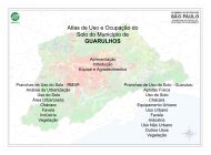
Atlas de Uso e Ocupação do Solo do Município de ... - Emplasa
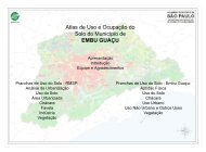
Atlas de Uso e Ocupação do Solo do Município de ... - Emplasa
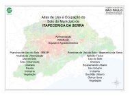
Atlas de Uso e Ocupação do Solo do Município de ... - Emplasa
- No tags were found...

You also want an ePaper? Increase the reach of your titles
YUMPU automatically turns print PDFs into web optimized ePapers that Google loves.
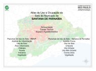
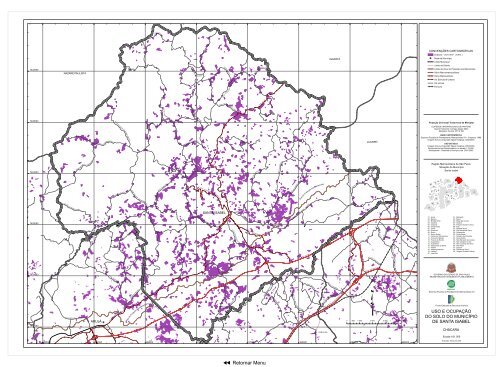
CONVENÇÕES CARTOGRÁFICASChácara - 34,15 km² ( 9,4% )!P Se<strong>de</strong> <strong>de</strong> <strong>Município</strong>Limite MunicipalLimite <strong>de</strong> Distrito########### Limite <strong>de</strong> Área <strong>de</strong> Proteção aos MananciaisViário MacrometropolitanoViário MetropolitanoVia Estrutural UrbanaVia VicinalFerroviaProjeção Universal Transversa <strong>de</strong> Mercator##ELIPSÓIDE INTERNACIONAL DE HAYFORDDatum Horizontal: Córrego Alegre (MG)Meridiano Central: 45º W GRBASE CARTOGRÁFICAEmpresa Paulista <strong>de</strong> Planejamento Metropolitano S A - <strong>Emplasa</strong>, 1980.Imagem Ikonos (Copyright Space Imaging), 2002/2003.USODOSOLOImagem Ikonos (Copyright Space Imaging), 2002/2003.Recobrimento Aerofotogramétrico na escala 1:15.000,Multispectral - Sistemas e Serviços Ltda 2001/2003.Região Metropolitana <strong>de</strong> São PauloSituação <strong>do</strong> <strong>Município</strong>Santa Isabel3012211354 115 141825312622329116 2419173373634############### # ######### # #################### ############ ############################ ######## ############# ############# ###### #######################ESTR. DA LAGE############ #################### ################ ################## ## ###### ######################## ############################################ #### ################################ ############################### ##### ####################### ############################### ################### ################## ###################### #############################################################ESTR. BOA VISTAESTR. DO ALTOQUARALESTR. DO T ANAZARÉ PAULISTAIGARATÁOUSO ALEGRE BOA VISTA################E S TR. DO P######### ######################## ####################################### ################ROD. SP-056ESTR. DO POU SO ALEGR EESTR. DOS BARBOSASESTR. DA B A RROCA FUNDA###### ##### ############## ### ########################### ########################### ####### ###### ###### ############ESTR. DA SERRA DAFINOPEDRA BRANCAJACAREÍESTR. DO OUROES TR. DA P E DRA BRANCA######## ### ################################ ###############EST R. DO FERREIRAABE RA B A- IT############################################################# ############ESTR. D O MONTE NEGRO## ################### ##################### ###### ################# ##################### ############ #########################ESTR. NOVA DO BAIRRO OURO FINO- JACAREÍESTR. JAGU ARI - PED RA BRANCAND EESTR. DA VARGEM GRAR. POÁESTR. VELHA STA. ISABEL!P############################## ## ###ES TR. HAMADAE STR. K ATOWADAESTR. SA##### ##################################### ####################### ###### ########IAESTR. DA MARIL ÂN DES TR. MUNICIPAL DE MORA ES MA GALH ÃESAV. VITOROD. PRES. DUTRAFAC CIOLLA### ##### ####################################### ############################# ################################################## ########################## ############ #### ############################# #########ROD. PRES. DUTRA############ ####### ## ################################################ ################## ################## ######################!P################################ ## ###### ##################### ###################### ################## ##########ESTR. PEDRA BRANCAESTR. OURO FINOROD. S P-056ES TRA DA PARTI C ULARAV.BRASILESTR. DO JA G UARIESTR. DE GUARA REMAESTR. ARALU JAGUARIESTR. CANGICASR. STA. CATARINAESTR. DO MIRABELESTR. MUNICIPAL ITAPEVIESTR. STA. ISABELESTR. BENEDITO MARCOLINOES TR. S. BEN TO DOES T R. DO NA GANOESTR. DA CACHOEIRAESTR. DO RETIROLA M BARIIOSESTR. DO VARADOUROROD. CARVALHO PINTOEST R. DAS BROTASROD. AYRTON SENNA DA SILVAAV. DOS EXPEDICION Á RAV. DO BRASILARUJÁSANTA ISABEL##### ########### ### #################### ###############################SABAÚNA360000 364000 368000 372000 376000 380000 384000 388000383922329872827163310352021 - Mairiporã22 - Mauá23 - Mogi das Cruzes24 - Osasco25 - Pirapora <strong>do</strong> Bom Jesus26 - Poá27 - Ribeirão Pires28 - Rio Gran<strong>de</strong> da Serra29 - Salesópolis30 - Santa Isabel31 - Santana <strong>de</strong> Parnaíba32 - Santo André33 - São Bernar<strong>do</strong> <strong>do</strong> Campo34 - São Caetano <strong>do</strong> Sul35 - São Lourenço da Serra36 - São Paulo37 - Suzano38 - Taboão da Serra39 - Vargem Gran<strong>de</strong> Paulista01 - Arujá02 - Barueri03 - Biritiba Mirim04 - Caieiras05 - Cajamar06 - Carapicuíba07 - Cotia08 - Dia<strong>de</strong>ma09 - Embu10 - Embu Guaçu11 - Ferraz <strong>de</strong> Vasconcelos12 - Francisco Morato13 - Franco da Rocha14 - Guararema15 - Guarulhos16 - Itapecerica da Serra17 - Itapevi18 - Itaquaquecetuba19 - Jandira20 - JuquitibaGOVERNO DO ESTADO DE SÃO PAULOSECRETARIA DE ECONOMIA E PLANEJAMENTOEmpresa Paulista <strong>de</strong> Planejamento Metropolitano S AFun<strong>do</strong> Estadual <strong>de</strong> Recursos HídricosUSO E OCUPAÇÃODO SOLO DO MUNICÍPIODE SANTA ISABELCHÁCARA1:61.000EscalaExecução: Março <strong>de</strong> 2006Área <strong>de</strong> Proteção aos Mananciais7432000q0 500 1.000 2.000 3.000 4.000 MetrosÁrea <strong>de</strong> Proteção aos Mananciais################################################################# ######################################## ####### ####################################################### ################################################################################# ######## ############### ######################################74280007424000742000074160007412000n Retornar Menu######################## ################