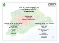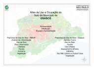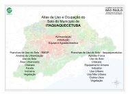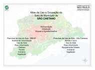
Atlas de Uso e Ocupação do Solo do Município de ... - Emplasa
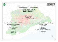
Atlas de Uso e Ocupação do Solo do Município de ... - Emplasa
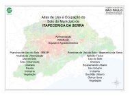
Atlas de Uso e Ocupação do Solo do Município de ... - Emplasa
- No tags were found...

Create successful ePaper yourself
Turn your PDF publications into a flip-book with our unique Google optimized e-Paper software.
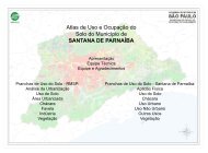
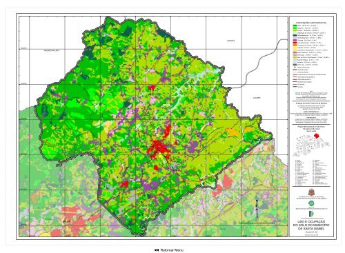
ESTR. DA LAGECONVENÇÕES CARTOGRÁFICASMata - 106,04 km² ( 29,20% )Capoeira - 34,07 km² ( 9,38% )Campo - 139,93 km² ( 38,52% )Vegetação <strong>de</strong> Várzea - 8,89 km² ( 2,45% )Reflorestamento - 14,73 km² ( 4,05% )Hortifrutigranjeiro - 6,6 km² ( 1,82% )IGARATÁChácara - 34,15 km² ( 9,4% )Área Urbanizada - 4,74 km² ( 1,3% )7432000NAZARÉ PAULISTAESTR. DO T AQUARALESTR. DO ALTOE S TR. DO POUSO ALEGRE BOA VISTAESTR. BOA VISTAROD. SP-056Equipamento Urbano - 0,88 km² ( 0,24% )Indústria - 0,8 km² ( 0,22% )Loteamento Desocupa<strong>do</strong> - 1,21 km² ( 0,33% )Aterro Sanitário - 0,08 km² ( 0,02% )Mineração - 2,96 km² ( 0,82% )Mov. <strong>de</strong> Terra / <strong>Solo</strong> Exposto - 3,6 km² ( 0,99% )Espelho D'água - 4 km² ( 1,1% )Ro<strong>do</strong>via - 0,33 km² ( 0,09% )Outro <strong>Uso</strong> - 0,24 km² ( 0,07% )!P Se<strong>de</strong> <strong>de</strong> <strong>Município</strong>Limite MunicipalLimite <strong>de</strong> DistritoESTR. DO POU SO ALEGR EReservatório <strong>do</strong> Jaguari###########Limite <strong>de</strong> Área <strong>de</strong> Proteção aos MananciaisViário MacrometropolitanoViário MetropolitanoESTR. DA B A RROCA FUNDAESTR. DOS BARBOSAS7428000Via Estrutural UrbanaVia VicinalFerroviaES TR. DA P E DRA BRANCAESTR. DA SERRA DAPEDRA BRANCAESTR. DO OUROFINOJACAREÍNota:As áreas <strong>de</strong> representação <strong>do</strong> uso e ocupação <strong>do</strong> solointernas e externas ao município utilizam as mesmasconvenções a<strong>do</strong>tadas na carta.Possuem tratamento gráfico diferencia<strong>do</strong> somentepara realçar os usos e ocupações <strong>de</strong>ste município.Projeção Universal Transversa <strong>de</strong> MercatorELIPSÓIDE INTERNACIONAL DE HAYFORDDatum Horizontal: Córrego Alegre (MG)Meridiano Central: 45º W GR74240007420000ES TRA DESTR. PEDRA BRANCAA PARTI C ULAR- ITABE RA B AESTR. DA VARGEM GRAND EESTR. JAGU ARI - PED RA BRANCAESTR. OURO FINOESTR. NOVA DO BAIRRO OURO FINOESTR. DO JA G UARIROD. S P-056SANTA ISABELAV.BRASILESTR. DO VARADOUROEST R. DO FERREIRAESTR. D O MONTE NEGROESTR. VELHA STA. ISABELÁrea <strong>de</strong> Proteção aos Mananciais- JACAREÍEST R. DAS BROTASR. POÁBASE CARTOGRÁFICAEmpresa Paulista <strong>de</strong> Planejamento Metropolitano S A - <strong>Emplasa</strong>, 1980.Imagem Ikonos (Copyright Space Imaging), 2002/2003.USODOSOLOImagem Ikonos (Copyright Space Imaging), 2002/2003.Recobrimento Aerofotogramétrico na escala 1:15.000,Multispectral - Sistemas e Serviços Ltda 2001/2003.2012213013525 4 115 14311839217 19 6 247Região Metropolitana <strong>de</strong> São PauloSituação <strong>do</strong> <strong>Município</strong>Santa Isabel359161038261136373432 22827 283323329ESTR. ARALU JAGUARIESTR. DA MARIL ÂN DIAESTR. DE GUARA REMAROD. PRES. DUTRAWADAESTR. SAAV. VITOFAC CIOLLAE STR. K ATOROD. CARVALHO PINTOES TR. HAMADAES TR. MUNICIPAL DE MORA ES MA GALH ÃES01 - Arujá02 - Barueri03 - Biritiba Mirim04 - Caieiras05 - Cajamar06 - Carapicuíba07 - Cotia08 - Dia<strong>de</strong>ma09 - Embu10 - Embu Guaçu11 - Ferraz <strong>de</strong> Vasconcelos12 - Francisco Morato13 - Franco da Rocha14 - Guararema15 - Guarulhos16 - Itapecerica da Serra17 - Itapevi18 - Itaquaquecetuba19 - Jandira20 - Juquitiba21 - Mairiporã22 - Mauá23 - Mogi das Cruzes24 - Osasco25 - Pirapora <strong>do</strong> Bom Jesus26 - Poá27 - Ribeirão Pires28 - Rio Gran<strong>de</strong> da Serra29 - Salesópolis30 - Santa Isabel31 - Santana <strong>de</strong> Parnaíba32 - Santo André33 - São Bernar<strong>do</strong> <strong>do</strong> Campo34 - São Caetano <strong>do</strong> Sul35 - São Lourenço da Serra36 - São Paulo37 - Suzano38 - Taboão da Serra39 - Vargem Gran<strong>de</strong> Paulista74160007412000AV. DO BRASILARUJÁESTR. CANGICASIOSAV. DOS EXPEDICION Á RESTR. DO RETIROÁrea <strong>de</strong> Proteção aos MananciaisESTR. STA. ISABELROD. PRES. DUTRAESTR. DA CACHOEIRAESTR. MUNICIPAL ITAPEVIES T R. DO NA GANOES TR. S. BEN TO DOLA M BARIESTR. DO MIRABELR. STA. CATARINAESTR. BENEDITO MARCOLINOSABAÚNAROD. AYRTON SENNA DA SILVAq0 500 1.000 2.000 3.000 4.000 MetrosGOVERNO DO ESTADO DE SÃO PAULOSECRETARIA DE ECONOMIA E PLANEJAMENTOEmpresa Paulista <strong>de</strong> Planejamento Metropolitano S AFun<strong>do</strong> Estadual <strong>de</strong> Recursos HídricosUSO E OCUPAÇÃODO SOLO DO MUNICÍPIODE SANTA ISABELEscala 1:61.000360000 364000 368000 372000 376000 380000 384000 388000Execução: Março <strong>de</strong> 2006n Retornar Menu