- Page 1 and 2: 1/2008
- Page 3 and 4: V. BODOCAN, Transformări structura
- Page 5 and 6: I. A. IRIMUŞ I. RUS, M. 0NCU The s
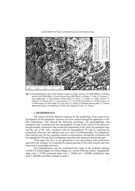
- Page 7: I. A. IRIMUŞ I. RUS, M. 0NCU The a
- Page 11 and 12: I. A. IRIMUŞ I. RUS, M. 0NCU At th
- Page 13 and 14: I. A. IRIMUŞ I. RUS, M. 0NCU 4. Bu
- Page 15 and 16: T. TUDOSE, F. MOLDOVAN 2. DATE ŞI
- Page 17 and 18: T. TUDOSE, F. MOLDOVAN Iarna, media
- Page 19 and 20: T. TUDOSE, F. MOLDOVAN 3. 4. Temper
- Page 21 and 22: T. TUDOSE, F. MOLDOVAN 9 în unită
- Page 23 and 24: T. TUDOSE, F. MOLDOVAN Numărul zil
- Page 25 and 26: I. HAIDU, I. E. KELLER 24 * * * Dur
- Page 27 and 28: I. HAIDU, I. E. KELLER 26 Fig. 1. S
- Page 29 and 30: I. HAIDU, I. E. KELLER Fig. 3. Pipe
- Page 31 and 32: I. HAIDU, I. E. KELLER Fig. 5. Iden
- Page 33 and 34: T. TUDOSE, F. MOLDOVAN 2. DATE ŞI
- Page 35 and 36: T. TUDOSE, F. MOLDOVAN Iarna, media
- Page 37 and 38: T. TUDOSE, F. MOLDOVAN 3. 4. Temper
- Page 39 and 40: T. TUDOSE, F. MOLDOVAN 9 în unită
- Page 41 and 42: T. TUDOSE, F. MOLDOVAN Numărul zil
- Page 43 and 44: S. GEACU 15°C and 64 ≥ 18°C. An
- Page 45 and 46: S. GEACU of male specimens. There a
- Page 47 and 48: C. N. BOłAN cu sau fără voinŃa
- Page 49 and 50: C. N. BOłAN De la cutumă la mit,
- Page 51 and 52: C. N. BOłAN 3. 3. Casa şi gospod
- Page 53 and 54: C. N. BOłAN dumneata, dumneavoastr
- Page 55 and 56: C. N. BOłAN dă în primul rând o
- Page 57 and 58: C. N. BOłAN pe care le-a tipărit
- Page 59 and 60:
C. N. BOłAN 4. BoŃan, C. (2005),
- Page 61 and 62:
SIMONA MĂLĂESCU derive from age p
- Page 63 and 64:
SIMONA MĂLĂESCU 2003, p. 133), th
- Page 65 and 66:
SIMONA MĂLĂESCU Fig. 1. Composite
- Page 67 and 68:
SIMONA MĂLĂESCU road network as w
- Page 69 and 70:
SIMONA MĂLĂESCU Miami Hotel, of t
- Page 71 and 72:
SIMONA MĂLĂESCU 10. Johnson, J.R.
- Page 73 and 74:
GR. P. POP Appeared and developed t
- Page 75 and 76:
GR. P. POP 1400 1200 No. inh. 1311
- Page 77 and 78:
GR. P. POP For comparison, with a v
- Page 79 and 80:
V. BODOCAN diverse pieŃe. Îmbătr
- Page 81 and 82:
V. BODOCAN cea mai mare densitate s
- Page 83 and 84:
V. BODOCAN Total Structura confesio
- Page 85 and 86:
V. BODOCAN PopulaŃia activă şi r
- Page 87 and 88:
V. BODOCAN B I B L I O G R A F I E
- Page 89 and 90:
A. NIłĂ the hills’ sides. In th
- Page 91 and 92:
A. NIłĂ The Great Invasion of the
- Page 93 and 94:
A. NIłĂ common constructions, exa
- Page 95 and 96:
ANCA-MIHAELA CÎRCU, I. - H. PAVEL
- Page 97 and 98:
ANCA-MIHAELA CÎRCU, I. - H. PAVEL
- Page 99 and 100:
ANCA-MIHAELA CÎRCU, I. - H. PAVEL
- Page 101 and 102:
ANCA-MIHAELA CÎRCU, I. - H. PAVEL
- Page 103 and 104:
AL. PĂCURAR, S. FILIP Structura ci
- Page 105 and 106:
AL. PĂCURAR, S. FILIP În privinŃ
- Page 107 and 108:
AL. PĂCURAR, S. FILIP legate de tr
- Page 109 and 110:
AL. PĂCURAR, S. FILIP Amplasarea t
- Page 111 and 112:
AL. PĂCURAR, S. FILIP Analiza cifr
- Page 113 and 114:
AL. PĂCURAR, S. FILIP mediul rural
- Page 115 and 116:
AL. PĂCURAR, S. FILIP O problemă
- Page 117 and 118:
AL. PĂCURAR, S. FILIP - valorifica
- Page 119 and 120:
AL. PĂCURAR, S. FILIP export pentr
- Page 121 and 122:
ŞT. DEZSI În acest context, orice
- Page 123 and 124:
ŞT. DEZSI Aspra (de la 0 la 4). Tr
- Page 125 and 126:
ŞT. DEZSI 11,3%), „avântul cons
- Page 127 and 128:
ŞT. DEZSI modest reprezentat este
- Page 129 and 130:
ŞT. DEZSI Fig. 1. EvoluŃia princi
- Page 131 and 132:
ŞT. DEZSI Cu valori ponderale rela
- Page 133 and 134:
ŞT. DEZSI accesibilitate, gradul d
- Page 135 and 136:
T. ANGHEL, DORINA CAMELIA ILIEŞ Di
- Page 137 and 138:
T. ANGHEL, DORINA CAMELIA ILIEŞ ha
- Page 139 and 140:
T. ANGHEL, DORINA CAMELIA ILIEŞ Va
- Page 141 and 142:
T. ANGHEL, DORINA CAMELIA ILIEŞ Th
- Page 143 and 144:
T. ANGHEL, DORINA CAMELIA ILIEŞ 26
- Page 145 and 146:
DANA-NELICA CAMPEAN ensuring other
- Page 147 and 148:
DANA-NELICA CAMPEAN REFERENCES 1. C
- Page 149 and 150:
ANGELICA PUŞCAŞ Fenomenul urban,
- Page 151 and 152:
ANGELICA PUŞCAŞ Dacă a fost priv
- Page 153 and 154:
ANGELICA PUŞCAŞ 150 Principalele
- Page 155 and 156:
ANGELICA PUŞCAŞ 4. CULTURI ŞI CI
- Page 157 and 158:
ANGELICA PUŞCAŞ Palatele şi vile
- Page 159 and 160:
ANGELICA PUŞCAŞ Sub dominaŃia di
- Page 161 and 162:
ANGELICA PUŞCAŞ ultimul rând, ş
- Page 163 and 164:
ANGELICA PUŞCAŞ Se detaşează, c
- Page 165 and 166:
D. COSTEA 162 2. 1. The Ancient Per
- Page 167 and 168:
D. COSTEA Between 1900 and 1918, so
- Page 169 and 170:
D. COSTEA Fig. 1. The Transylvania
- Page 171 and 172:
D. COSTEA 3. CONCLUSIONS First of a
- Page 173 and 174:
PÉTER KATONA important factor in t
- Page 175 and 176:
PÉTER KATONA 172 3. METHODS In ord
- Page 177 and 178:
PÉTER KATONA 5. CONCLUSIONS Studyi
- Page 179 and 180:
MARTIN BIRTEL 2. TOURISMUS IN RUMÄ
- Page 181 and 182:
MARTIN BIRTEL b) Ländlicher Touris
- Page 183 and 184:
MARTIN BIRTEL In jüngerer Zeit sin
- Page 185 and 186:
MARTIN BIRTEL Einkommen durch Touri
- Page 187 and 188:
MARTIN BIRTEL lässt sich folgern,
- Page 189 and 190:
MARTIN BIRTEL 2. Benedek, J., Dezsi
- Page 191 and 192:
LELIA PAPP publică locală, agenŃ
- Page 193 and 194:
LELIA PAPP ridicat al acestei categ
- Page 195 and 196:
LELIA PAPP municipiul Turda (7,5 %)
- Page 197 and 198:
LELIA PAPP calitatea educaŃională
- Page 199 and 200:
ZS. BARTOS-ELEKES with Aurousseau
- Page 201 and 202:
ZS. BARTOS-ELEKES So the UN definit
- Page 203 and 204:
ZS. BARTOS-ELEKES power in the nine
- Page 205 and 206:
ZS. BARTOS-ELEKES 3. Back, Otto - B
- Page 207 and 208:
W. E. SCHREIBER einem Vorläufer de
- Page 209 and 210:
W. E. SCHREIBER b) Von den in Rumä
- Page 211 and 212:
W. E. SCHREIBER 6. Wachner, H. (192
- Page 213 and 214:
GR. P. POP personalităŃile france
- Page 215 and 216:
GR. P. POP franco-română la Unive
- Page 217 and 218:
GR. P. POP În urma relaŃiilor deo
- Page 219 and 220:
GR. P. POP - faŃă de propunerile
- Page 221 and 222:
KOVÁCS HAJNAL Mărişel˝ levelled