ROGTEC Issue 47
Russian Oil & Gas Magazine
Russian Oil & Gas Magazine

You also want an ePaper? Increase the reach of your titles
YUMPU automatically turns print PDFs into web optimized ePapers that Google loves.
ГЕОФИЗИЧЕСКИЕ ИССЛЕДОВАНИЯ СКВАЖИН<br />
without information about the geological structure and<br />
bedding peculiarities.<br />
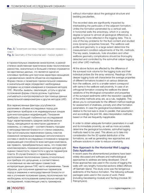
Рис. 3. Геометрия системы горизонтальная скважина –<br />
пласт<br />
Fig. 3. Geometry of the horizontal well – horizon system<br />
в горизонтальных скважинах анизотропия, в разной<br />
степени свойственная практически всем геологическим<br />
разностям, значительно в большей степени отражается<br />
на каротажных данных, что является одной из<br />
ключевых проблем для прогноза характера насыщения<br />
и динамических свойств объектов исследования.<br />
Форма стенок и геометрия горизонтальной скважины<br />
в значительной мере определяют необходимые<br />
поправки на условия измерения в показания методов<br />
ГИС. Желобы, вывалы, овализация, уступы и другие<br />
осложнения формы ствола должны тщательно<br />
учитываться и контролироваться при помощи данных<br />
азимутальной кавернометрии и других методов LWD.<br />
Все перечисленные факторы усугубляются<br />
различием в объеме исследуемых пород для<br />
каротажных приборов и их индивидуальных зондов<br />
(для многозондовых модификаций). Показания<br />
приборов с большей глубинностью исследований<br />
будут характеризовать средние свойства разных<br />
пород, находящихся на некотором удалении от<br />
скважины, а с меньшей – соответствовать породам<br />
в непосредственной близости от стенки скважины.<br />
При ортогональном пересечении границ пластов<br />
скважиной латеральные вариации литологического<br />
состава и свойств исследуемых отложений в пределах<br />
разрешающей способности всех методов комплекса,<br />
как правило, пренебрежительно малы, что позволяет<br />
комплексировать показания различных методов для<br />
оценки глинистости, пористости и других параметров<br />
пласта. В случае близкого к параллельному<br />
расположения геологических границ относительно<br />
оси прибора это допущение, а соответственно<br />
и основанные на нем методики совместной<br />
интерпретации данных ГИС часто неприменимы. Таким<br />
образом, для получения адекватных параметров<br />
пород в скважине и непосредственной близости от<br />
нее и уточнения положения границ геологических тел<br />
необходимы использование азимутальных методов<br />
исследований, позволяющих учесть трехмерное<br />
28 <strong>ROGTEC</strong><br />
The recorded data are significantly impacted by<br />
interbedding the particulars of the adjacent formation.<br />
Unlike the formation penetrated by a vertical well,<br />
in horizontal wells the anisotropy, which in a varying<br />
degree is typical to almost all geological differences, is<br />
significantly more reflected in the logging data. This is<br />
one of the key problems for the fluid content and studied<br />
zone dynamic properties forecast. The wellbore wall<br />
profile and geometry to a large extent determine the<br />
measurement condition adjustments of the WL methods.<br />
The key seats, breakouts, hole shoulders and other<br />
wellbore geometry complications should be thoroughly<br />
detected and controlled by the azimuthal caliper logging<br />
and other LWD methods.<br />
All the above factors are affected by the difference of<br />
the surveyed rock volume for the logging tools and their<br />
individual probes (for the array versions). Readings of the<br />
deeper logging tools will characterize the average properties<br />
of different formations located in at various distances<br />
from the wellbore, and to a smaller extent correspond<br />
with same in the wellbore wall proximity. In case of an<br />
orthogonal formation crossing the wellbore the lateral<br />
variations of the lithological composition and properties<br />
of the surveyed sediments within the resolution capability<br />
of the entire methods array are, as a rule, negligible. This<br />
allows you to compensate for the different method readings<br />
for assessment of shaliness, porosity and other formation<br />
parameters. In case the geological boundaries position<br />
relative to the tool axis is close to parallel, that assumption<br />
and accordingly the joint WL data interpretation methods<br />
based on that are frequently inapplicable.<br />
In order to obtain adequate formation parameters in a well<br />
and its immediate proximity, as well as more accurately<br />
determine the geological boundaries, azimuthal logging<br />
methods need to be used. This allows us to take into<br />
consideration the the 3D spatial distribution of the<br />
formations, as well as generating new approaches and<br />
software solutions in order to reduce uncertainty.<br />
New Approach to the Horizontal Well Logging<br />
Data Application<br />
In recent years the aforementioned problems have been<br />
widely discussed and software and methodological<br />
approaches to address are being developed. One of<br />
those approaches was used in the course of logging the<br />
wells with very lengthy horizontal sections drilled offshore<br />
off Sakhalin Island. The study zone was the terrigenous<br />
sediments of the Nutovo formation. The following software<br />
packages were used in the course of work: Petrel<br />
(including Geosteering module) and Techlog (module 3D<br />
Petrophysics).<br />
www.rogtecmagazine.com