Ammaia-Uma-cidade-romana-LR
Ammaia-Uma-cidade-romana-LR
Ammaia-Uma-cidade-romana-LR

Create successful ePaper yourself
Turn your PDF publications into a flip-book with our unique Google optimized e-Paper software.
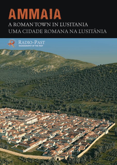
AMMAIAA ROMAN TOWN IN LUSITANIAUMA CIDADE ROMANA NA LUSITÂNIA
Radiography of the past.Exploring “the invisible” inarchaeological sitesMost people think that archaeology is equal to“excavations” and that everything in archaeologyis about “finding”. Nothing could be further fromthe truth: archaeology is all about understandingand in some ways the closest parallel for our jobis with police investigative procedures.In addition to, and sometimes instead of, excavationmany other instruments and approachesare available to researchers for the reconstructionof ancient landscapes and townscapes.Aerial photography, for instance, has been usedby archaeologists since the origin of photographyitself, to “spot” from the air traces of buriedarchaeological features 1 . Equally, survey andsurface artefact collection are applied mainlyto detect the presence of human settlement,mostly in the countryside and in green-fieldareas. Relatively more recently (the first experimentswere performed in the 1940s) differentgeophysical survey techniques have been appliedto detect subsoil archaeological features. A lotof information can also be found in historicaldocuments and archives, in ancient sources andhistorical cartography.This wide range of research methodologies cantoday be defined as “archaeological diagnostics”:as in medicine, we can make a diagnosisassessing the state of the art (medical history),analysing the phenomena and evidence visiblefrom outside (symptomatology), applyinginstrumental diagnostics and finally resolvingto excavation (surgery) only when and wherereally needed, with the least “invasive” approachpossible.In this way, we can collect a lot of informationabout what is still buried under the ground, andin the best cases, once all these data are piecedtogether, we have something comparable to a“radiography” of the subsoil features 2 .The integration of all these techniques hasbrought archaeology in the third millenniumtoward a restraint from excavations, as excavationsare not only costly and time-consuming butRadiografia do passado.A exploração do «invisível»em sítios arqueológicosA maioria das pessoas pensa que arqueologia é sinónimode «escavações» e associa-a ao ato de «descobrir».Nada poderia estar mais longe da verdade: aarqueologia implica compreender e, neste sentido, épossível estabelecer uma comparação muito próximaentre o trabalho dos arqueólogos e os procedimentosda investigação policial.Para além de (e por vezes em vez de) escavações,os investigadores dispõem de muitos outros instrumentose abordagens que lhes permitem reconstituirantigas paisagens rurais e urbanas. A fotografiaaérea, por exemplo, é utilizada pelos arqueólogosdesde a origem da própria fotografia para «detetar»a partir do ar a presença de vestígios arqueológicossoterrados 1 . Da mesma forma, a prospeção e arecolha de artefactos à superfície do terreno aplicam--se para detetar a presença de antigas instalaçõeshumanas, sobretudo em zonas rurais. Mais recentemente(referimo-nos aqui a experiências realizadasa partir da década de 1940), diferentes técnicas deprospeção geofísica têm sido utilizadas para detetarvestígios arqueológicos no subsolo. É ainda possívelencontrar muita informação em documentos earquivos históricos, fontes documentais antigas ena cartografia histórica.Este vasto leque de instrumentos de investigaçãoenquadra-se atualmente no âmbito do chamado «diagnósticoarqueológico»: à semelhança do que sucedena medicina, é possível proceder a um diagnósticoonde se avalia o «estado da arte» (historial clínico),se analisam vestígios visíveis a partir do exterior(sintomatologia), se aplica o diagnóstico instrumentale, finalmente, se opta pela escavação (cirurgia), apenasquando e onde esta for estritamente necessária,recorrendo a uma abordagem o menos «invasiva» possível.Deste modo, podemos recolher muita informaçãosobre o que ainda se encontra soterrado e, uma vezreunidos todos estes dados, proceder, nos casos maisbem-sucedidos, a uma «radiografia» das realidadesocultas no subsolo 2 .A integração de todas estas técnicas conduziu aarqueologia, neste terceiro milénio, a uma contençãonas campanhas de escavação. As escavações3
– most problematically – each monument that isbrought to light requires specialized, costly andoften environmentally unsustainable restorationinterventions.To explore the new possibilities made possible bythe technological and methodological improvementsachieved in the last 20 years, the Europeanfunded project Radio-Past was launched onApril 1 st 2009, with the aim of exploring new possibilitiesfor integration of these “non-invasive”approaches, but also to develop effective waysto visualise these data.It is essential, in fact, that specialists can disseminatethis knowledge to the wider public.Another important objective of the project isto find ways to evaluate and manage this specialcategory of archaeological sites, wherevisitors are confronted with “invisible” ancientsettlements.The “consortium” of partners within the projectis composed of four academic institutions (theuniversities of Évora – Portugal, Ghent – Belgiumand Ljubljana – Slovenia, and the British Schoolat Rome – UK), with three SMEs (Eastern Atlassão caras, morosas e, sobretudo, cada monumentotrazido à luz do dia requer outras intervenções especializadas,de conservação e restauro, dispendiosase muitas vezes pouco sustentáveis do ponto de vistaambiental.Com vista a explorar as novas potencialidades suscitadaspelos desenvolvimentos tecnológicos emetodológicos dos últimos vinte anos, o projetoRadio‐Past, financiado pela União Europeia, foi lançadoa 1 de Abril de 2009 com o objetivo não só deinvestigar novas possibilidades para a integraçãodestas abordagens «não-invasivas», mas também dedesenvolver modos eficazes de visualizar os dadosobtidos.Com efeito, é essencial que os investigadores possamdivulgar este conhecimento junto de um públicomais alargado. Um outro importante objetivo desteprojeto é encontrar modos de valorizar e gerir estacategoria especial de sítios arqueológicos, ondeos visitantes são confrontados com povoamentosantigos «invisíveis».O «consórcio» de parceiros reunidos neste projetoé composto por quatro instituições académicas (asuniversidades de Évora, em Portugal; de Ghent,14
2– Germany, 7reasons – Austria and Past2Present– The Netherlands).The partners have selected several “test sites”where they have gathered to cooperate in fieldwork,experimentation and training activities.The cooperative process of interpretation andthe discussion of the scientific aspects amongspecialists of different fields have brought spectacularresults.Here, we will guide you through the “underworld”of <strong>Ammaia</strong>, trying to make you experience the“invisible” reality of a Roman town in Lusitania.Enjoy the ride!C.C.na Bélgica; de Liubliana, na Eslovénia; e a BritishSchool at Rome, do Reino Unido) e três PME (a alemãEastern Atlas, a austríaca 7reasons e a holandesaPast2Present).Os parceiros procederam à seleção de diversos «sítiosde ensaio», onde se reuniram para colaborar no trabalhode campo e em atividades de experimentaçãoe formação. O processo de cooperação entre especialistasde diferentes domínios, na interpretação ediscussão dos aspetos científicos, trouxe resultadosextraordinários.Aqui, guiá-lo-emos através do «submundo» de<strong>Ammaia</strong> com o intuito de lhe proporcionar a vivênciada realidade «invisível» de uma <strong>cidade</strong> <strong>romana</strong>na Lusitânia.Desfrute desta aventura!C.C.5
<strong>Ammaia</strong> in the context ofLusitaniaWhile many archaeological discoveries in the widerregion of <strong>Ammaia</strong>, and especially in the Tagusbasin, prove human occupation during the StoneAge, the area received important new impulsesduring the later Bronze Age. Near the end of thesecond millennium BC new Indo-European populationsentered the Iberian Peninsula. Of these,the Lusitani tribes settled in the Beira region andparts of Spanish Extremadura, while the Conii tribessettled in the Alentejo, the southern part of theSpanish Extremadura and the Algarve. The area,where <strong>Ammaia</strong> would later be founded, was situatedin the contact zone of both populations. Thesubsequent arrival in several waves, around 500 and250 BC, of Celtic populations, baring iron weaponsand tools, brought new blood to the region.This coincides with an increasing Mediterraneaninfluence, and contact with the more developedcultures of the Tartessian, Phoenician, Greek andCarthaginian colonists that had settled along thesouthern Iberian coasts. This period also marks achange in the settlement pattern of the region.Existing settlements of the indigenous Iron agepopulations are gradually abandoned and replacedby larger, fortified towns as a response to the growingsocio-economic, politic and military instability,such as that caused by the military campaignsof the Romans in the Iberian Peninsula after theSecond Punic War (218 – 201 BC).After the defeat of the Carthaginians, the Romanpresence in the coastal areas of the eastern andsouthern part of the Iberian Peninsula was definitivelyestablished. During the next two centuries,the Romans gradually annexed the entire Peninsula.For the <strong>Ammaia</strong> region, this must have takenplace between 178 BC, when the first Roman armyunder command of L. Postumius Albinus arrivedin the region, and 138 BC, when Decimus JuniusBrutus conquered Olisipo (Lisbon) and Moron (nearSantarém) and consolidated the Roman presencesouth of the Tagus River. The definitive integrationof this area south of the Tagus River is dated to72 BC, after the Sertorian rebellion.During the first decades of Roman military control,existing indigenous settlements continued to be<strong>Ammaia</strong> no contexto daLusitaniaEmbora muitos dados arqueológicos da região envolventede <strong>Ammaia</strong> e, em particular, da bacia do Tejo,atestem a ocupação humana durante a Pré-História, aárea conheceu importantes transformações durante oBronze Final. Em fins do segundo milénio a.C., novaspopulações indo-europeias chegaram à PenínsulaIbérica, entre as quais se identificam os Lusitanos, quese estabeleceram na região da Beira e na Extremaduraespanhola, e os Cónios, que ocuparam o Alentejo,as áreas meridionais da Extremadura espanhola eo Algarve. A área do futuro território de <strong>Ammaia</strong>situava-se na zona de contacto entre ambas as populações.Entre 500 a 250 a.C., a chegada de distintasvagas de populações célticas, portadoras de armas eferramentas de ferro, trouxe novo sangue à região.Este período coincide com uma crescente influênciado Mediterrâneo e o contacto com as culturas maisdesenvolvidas de tartéssios e colonos fenícios, gregose cartagineses, estabelecidos ao longo da costa sulda Península Ibérica. Este período regista tambémuma mudança no padrão de povoamento da região.Os anteriores povoados indígenas da Idade do Ferroforam progressivamente abandonados e substituídospor povoados fortificados de maiores dimensões emresposta à crescente instabilidade socioeconómica,política e militar, designadamente as campanhas militares<strong>romana</strong>s na Península Ibérica depois da SegundaGuerra Púnica (218-201 a.C.).Após a derrota dos Cartagineses, a presença <strong>romana</strong>nas regiões costeiras a leste e sul da Península Ibéricaestabeleceu-se definitivamente. Ao longo dos doisséculos seguintes, os Romanos apoderaram-se progressivamentede toda a Península. No que respeitaà região de <strong>Ammaia</strong>, esta ocupação terá tido lugarentre 178 a.C. – quando o primeiro exército romano,sob o comando de Lúcio Póstumo Albino, chegou àregião –, e 138 a.C., quando o general Décimo JúnioBruto conquistou Olisipo (Lisboa) e Moron (pertode Santarém), consolidando a presença <strong>romana</strong> asul do rio Tejo. A integração definitiva desta regiãoconsumou-se em 72 a.C., depois da guerra Sertoriana.Durante as primeiras décadas de controlo militarromano, os povoados indígenas continuaram ocupados,sendo a presença <strong>romana</strong> bastante limitada. Estasituação alterou-se sensivelmente na primeira metade7
inhabited and actual Roman presence was ratherlimited. This changed when, around the mid-firstcentury BC, the first Roman immigrants arrived tosettle here permanently. This settlement led to afull territorial and political reorganization underAugustus, consolidated by the foundation of properRoman towns from 27 BC onwards. The provinceof Lusitania was thus created, covering an areathat takes in most of present-day Portugal (exceptthe North) and a part of neighbouring SpanishExtremadura. As capital the new colonial city ofEmerita Augusta (Mérida) was chosen 4 whilemany other important towns were developed, suchas the central Lusitanian towns of Pax Iulia (Beja),Olisippo (Lisbon), Norba Caesarina (Cáceres) andEbora Liberalitas Iulia (Évora) 3 .Probably around the beginning of our era the Romanadministration decided to found also a new midsizedtown in the area of the Serra de São Mamede,near the new road system of central Lusitania thatconnected the capital Emerita Augusta with theAtlantic coast 5 . The town of <strong>Ammaia</strong> was born,probably settled by immigrants as well as membersof the indigenous populations of this region. Likeother towns in the province, <strong>Ammaia</strong> undoubtedlyfunctioned as an urban and political-administrativecentre from where the surrounding lands could begoverned efficiently.The urban settlement of <strong>Ammaia</strong> thus became partof a major change in the Iberian Peninsula thatcame with the spread of new Roman self-governingcommunities that created new foci of power inthe region. This new framework was facilitated bythe gradual ceding of self-governing status (municipium)to all free communities in the provinceof Lusitania between the reign of Augustus andthe late first century AD. These new arrangementsprecipitated also major changes in the pattern ofrural settlement across the region, reaching significantdensities by the Flavian period (late firstcentury AD).The Roman town of <strong>Ammaia</strong> was the geographiccentre of a territory of almost 4000 km 2 , situatedsouth of the Tagus River and extending on bothsides of the present-day Portuguese-Spanish border.It comprised other smaller population centres inthe territory, such as Abelterium (Alter do Chão),and Vicus Camalocensis (near Crato), which mainlydo século I a.C., época em que os primeiros imigrantesitálicos chegaram para aqui se instalarem. No principadode Augusto, regista-se uma ampla reorganizaçãoterritorial e política, consolidada pela fundação deverdadeiras <strong>cidade</strong>s <strong>romana</strong>s a partir do ano 27 a.C. Foiassim criada a província da Lusitania, abarcando umaárea geográfica que compreendia boa parte do atualterritório português (excluindo o Norte) e parte davizinha Extremadura espanhola. A capital da provínciaestabeleceu-se na nova colonia de Emerita Augusta(atual Mérida) 4 e desenvolveram-se outros centrosimportantes, como as <strong>cidade</strong>s lusitanas de Pax Iulia(Beja), Olisippo (Lisboa), Norba Caesarina (Cáceres)e Ebora Liberalitas Iulia (Évora) 3 .Provavelmente por volta dos inícios da nossa Era, aadministração <strong>romana</strong> decidiu fundar uma nova <strong>cidade</strong>de dimensão média na área da Serra de São Mamede,junto à nova rede viária da Lusitania central, queestabelecia a ligação entre a capital Emerita Augustae a costa atlântica 5 . Assim nasceu a <strong>cidade</strong> de<strong>Ammaia</strong>, possivelmente estabelecida por imigrantese pelas populações indígenas. À semelhança de outras<strong>cidade</strong>s da província, sem dúvida que <strong>Ammaia</strong> funcionavacomo centro urbano político-administrativo quegeria eficazmente o território circundante.O aglomerado urbano de <strong>Ammaia</strong> tornou-se, portanto,parte integrante da grande transformação operadana Península Ibérica pelos romanos: comunidadesautónomas fundadas de raiz que passaram a constituiros novos centros de poder na região. Este novoenquadramento foi potenciado pela concessão gradualdo estatuto municipal (municipum) a todas ascomunidades livres da província da Lusitania, entreo principado de Augusto e os finais do século I d.C.Esta nova configuração implicou também importantesalterações no padrão do povoamento rural em toda aregião, atingindo densidades significativas no períodoflaviano (finais do século I d.C.).A <strong>cidade</strong> <strong>romana</strong> de <strong>Ammaia</strong> era o lugar central de umterritório com quase 4.000 km 2 , a sul do rio Tejo, quese estendia a ambos os lados da atual fronteira entrePortugal e Espanha. Este território abrangia outrosnúcleos populacionais menores, como Abelterium(Alter do Chão) e Vicus Camalocensis (na zona doCrato), que entretanto haviam emergido nos principaisentroncamentos da rede viária, bem como umaextensa mancha de assentamentos rurais responsáveispela exploração do território. Alguns destes núcleos8
4 5emerged on the main crossroads of the road network.Furthermore, an extensive network of rural farms wasresponsible for the exploitation of the landscape.Some were relatively small and served to supply thetown with the necessary goods for its daily subsistence,such as food, building stone, wood and metal.Others, located further away from the urban centre,developed into large villa estates, such as at Torrede Palma. Most of these large villa estates producedgoods, such as olive oil, wine and horses, partly forexport to external markets. Architecturally they wereexponents of the Roman Mediterranean way of life,richly decorated with marble and mosaics and oftenincorporating bathing facilities in addition to residentialand industrial or artisanal functions. Besidescrop cultivation and livestock farming (cattle, sheep,pigs), another important economic activity in thestudy area was the mining of mineral resources,mainly iron and lead. Remains of these extractiveactivities are plentiful in the territory of <strong>Ammaia</strong>.More valuable minerals such as gold (near the Tagus)and rock crystal, for the manufacture of glass andjewellery, were mined as well. The importance ofrock crystal is illustrated by two references in theNaturalis Historia by Pliny the Elder, to the presenceof the mineral in the hills around <strong>Ammaia</strong>.This system of the well-organized town and marketcentre of <strong>Ammaia</strong> and its rural and industrialhinterland flourished deep into the fourth century.From the fifth century onwards the decline andfinal collapse of the Roman economic system andthe invasion of Germanic peoples (Sueves, Vandals,Alans) resulted in a gradual abandonment of theurban centres of Lusitania. While some, like Méridaknew continuity under the subsequent Visigothicrule, that from the year 585 incorporated the entirePeninsula, many others like <strong>Ammaia</strong> declined graduallyand were sometimes completely abandoned.F.V.eram relativamente modestos, servindo para abastecera <strong>cidade</strong> dos bens necessários à subsistência diária,como alimentos, pedra para construção, madeira emetal. Outros, mais distantes do centro urbano, transformaram-seem grandes propriedades rurais (villae),como é o caso de Torre de Palma. Na sua grande maioria,estas villae dedicavam-se à produção de azeite,vinho ou à criação de cavalos, em parte destinados àexportação. Em termos arquitetónicos, eram expoentesdo modo de vida mediterrâneo romano, ricamenteornamentadas com mármore e mosaicos e, em geral,incluíam instalações para banhos, a par da área residenciale das estruturas ligadas às funções laborais ede manufatura. Para além da agricultura e da criaçãode gado (bovino, ovino e suíno), a exploração dosrecursos minerais, principalmente ferro e chumbo,constituía outra atividade económica importante,sendo abundantes os vestígios da extração mineirano território de <strong>Ammaia</strong>. Também os minerais maisvaliosos foram explorados, como o ouro (perto doTejo) e o cristal de rocha, para o fabrico de vidro ejoalharia. A importância do cristal de rocha é ilustradapor duas referências à presença deste mineral na serrade São Mamede, incluídas na Naturalis Historia dePlínio o Velho.O modelo estabelecido em <strong>Ammaia</strong>, uma <strong>cidade</strong> bemorganizada dotada de mercado e de um territóriorural e industrial, floresceu ao longo do século IV.A partir do século V, o declínio e o derradeiro colapsodo sistema económico romano, bem como a invasãode povos germânicos (Suevos, Vândalos, Alanos),ditaram o progressivo abandono dos centros urbanosda Lusitania. Enquanto algumas <strong>cidade</strong>s, comoMérida, se mantiveram sob o subsequente domíniovisigodo, que a partir do ano 585 se apoderou de todaa Península Ibérica, muitas outras, à semelhança de<strong>Ammaia</strong>, entraram gradualmente em declínio e foram,em alguns casos, completamente abandonadas.F.V.9
The discovery of <strong>Ammaia</strong>and its history according toancient sourcesThe site of the former Roman town of <strong>Ammaia</strong>is located in the municipality of Marvão, in thedistrict of Portalegre in the Alto Alentejo. Thearchaeological evidence of this now-abandonedtown-site lies on the hillside immediately southof the small “street-village” of São Salvador deAramenha, in the valley of the Rio Sever.The standing ruins still visible above-ground hadalready attracted the attention of Portugueseand Spanish historians in the sixteenth century,when the monuments of the ancient towns weredespoiled to procure readily available buildingstones. In 1710 the then-still-standing southerngate of <strong>Ammaia</strong> was transferred to the neighbouringvillage of Castelo de Vide, where it stayed inuse until 1891 6 . During the later nineteenthcentury and the early twentieth century, the firstexcavations revealed some of the town’s necropoleisand many intact Roman burial gifts foundtheir way into private and public collections.Until that period, archaeologists and historiansbelieved that the ruins near São Salvadorda Aramenha belonged to the Roman town ofMedobriga and that the remains of <strong>Ammaia</strong> werelocated underneath the modern town of Portalegre,more than 10km to the south. It was not until1935, when Leite de Vasconcelos published a paperon the discovery of an honorific inscription dedicatedto the Emperor Claudius (IRCP 615), thatthe Roman remains near São Salvador da Aramenhawere identified as those of <strong>Ammaia</strong>. Shortly after,the site was declared a National Monument (1949)and in 1994 the central area of the Roman townreceived the protected status of archaeologicalpark. Since then, archaeological fieldwork andexcavations have been taking place in <strong>Ammaia</strong>almost continuously, the operations organised bythe Fundação Cidade de <strong>Ammaia</strong>, in partnershipwith the Portuguese universities of Coimbra andÉvora (the latter, still “scientific” coordinator of thesite), in collaboration with several foreign universities,such as Ghent (Belgium), Louisville (USA),Cassino (Italy) and Dublin (Ireland).A descoberta de <strong>Ammaia</strong>e a sua história segundofontes antigasO sítio arqueológico da antiga <strong>cidade</strong> <strong>romana</strong> de<strong>Ammaia</strong> encontra-se no concelho de Marvão, distritode Portalegre, na região do Alto Alentejo. Os vestígiosarqueológicos desta <strong>cidade</strong>, hoje abandonada,situam-se na encosta a sul da pequena vila de SãoSalvador da Aramenha, no vale do rio Sever.A parte ainda visível das suas ruínas chamou a atençãode eruditos portugueses e espanhóis logo noséculo XVI, quando as <strong>cidade</strong>s antigas foram saqueadaspara obter pedra de construção. Em 1710, oentão ainda conservado arco da Porta Sul de <strong>Ammaia</strong>foi transferido para a vila vizinha de Castelo de Vide,onde permaneceu em uso até 1891 6 . Entre finsdo século XIX e o início do século XX, as primeirasescavações revelaram algumas das necrópoles da<strong>cidade</strong> e muitas das ainda intactas oferendas funerárias<strong>romana</strong>s vieram a integrar coleções públicase privadas.Até essa data, arqueólogos e historiadores acreditavamque as ruínas próximas de São Salvador daAramenha pertenciam à <strong>cidade</strong> <strong>romana</strong> de Medobriga,e que os vestígios de <strong>Ammaia</strong> se encontravam soba moderna <strong>cidade</strong> de Portalegre, mais de dez quilómetrosa sul. Somente em 1935, quando Leite deVasconcelos publicou um artigo sobre a descobertade uma inscrição honorífica dedicada ao ImperadorCláudio (IRCP 615), foram as ruínas <strong>romana</strong>s próximasde São Salvador da Aramenha identificadas comoa antiga <strong>cidade</strong> de <strong>Ammaia</strong>. Pouco depois, o local foiclassificado como Monumento Nacional (1949) e, em1994, a área central da <strong>cidade</strong> recebeu a proteçãolegal que hoje detém. Desde então, os trabalhosarqueológicos de campo e as escavações têm decorridoem <strong>Ammaia</strong>, de um modo contínuo, organizadospela Fundação Cidade de <strong>Ammaia</strong> em parceria comas universidades portuguesas de Coimbra e Évora(assumindo esta última a coordenação científica dosítio) e com várias universidades estrangeiras, taiscomo Ghent (Bélgica), Louisville (EUA), Cassino(Itália) e Dublin (Irlanda).As primeiras escavações concentraram-se essencialmentenas áreas onde as ruínas visíveis indicavamclaramente a presença de vestígios romanos 7 .11
7Early excavations have focused essentially onareas where visible ruins indicated the presenceof subsurface Roman remains 7 . These areasincluded parts of the city wall and the southerngate (Porta Sul) with associated monumentalsquare and residential buildings, parts of a publicEssas áreas incluíam parte da muralha da <strong>cidade</strong> ea entrada meridional (Porta Sul), com a sua praçapública monumental e edifícios residenciais, parte deum complexo de banhos públicos (Termae) e partedo complexo do fórum, onde o núcleo do pódio dotemplo, construído em opus caementicium (o típico12
athhouse (Termas), and parts of the forum complexwhere the caementicium (the typical Romanconcrete) core of the temple podium was stillpresent above ground. In addition, a residentialarea underneath an abandoned farmhouse(Quinta do Deão) that now hosts the museum,betão romano), ainda era visível acima do solo. Alémdisso, procedeu-se à escavação integral de uma árearesidencial situada sob um edifício abandonado daQuinta do Deão, que agora alberga o museu monográfico,e de uma pequena área suburbana situadaentre a <strong>cidade</strong> e o rio Sever. Em 2001, a par das escavações,tiveram início outros tipos de investigação,nomeadamente um extenso programa de pesquisageoarqueológica, levando à descoberta dos aquedutosromanos 8 , à delineação hipotética do circuitoda muralha 18, à compreensão da relação entre a<strong>cidade</strong> e a paisagem circundante e à identificaçãode alguns recursos básicos da economia urbana, taiscomo as pedras usadas nas construções, os mineraise os metais.<strong>Uma</strong> nova etapa da investigação teve início em 2009,com o lançamento do projeto Radio-Past, que selecionou<strong>Ammaia</strong>, como um dos principais laboratóriosabertos para testar a integração de abordagens não--destrutivas. Um levantamento «integral» da <strong>cidade</strong>e dos seus subúrbios permitiu a reconstituição dodesenho urbano, com a delimitação da sua rede deruas e a definição das características planimétricas dosseus principais monumentos e áreas habitacionais 18.Enquanto parte integrante da nova agenda de investigação,o estudo das diversas categorias de artefactos(cerâmicas finas e comuns, ânforas, moedas,vidros, etc.) e a reavaliação dos registos das antigasescavações conduziram a um novo entendimentoda história de <strong>Ammaia</strong> distinto do anteriormenteconhecido. <strong>Ammaia</strong> não conheceu grande projeçãona literatura antiga: praticamente não é citada, comexceção de uma indicação das suas coordenadasastronómicas em Ptolemeu (II, 5, 8) e de uma brevemenção da serrania próxima (a Ammaeensia Iuga)na enciclopédica obra de Plínio o Velho, como localonde foi encontrado um cristal de rocha de dimensãoexcecional (N.H. XXXVII, 24; XXXVII, 127). Mas ofamoso erudito não refere <strong>Ammaia</strong> na sua lista decivitates da Lusitânia, contida no livro IV, 117-118da sua Naturalis Historia.A análise do registo arqueológico até agora produzidopermite estabelecer que a fundação de <strong>Ammaia</strong> sedeu durante o principado de Augusto, possivelmentenos últimos anos do século primeiro a.C., ou logono início da nossa Era. A sua fundação resulta claramentede um projeto bem definido, destinado a estabelecerum ponto de povoamento que funcionasse13
and a small suburban area between the town andthe River Sever were fully excavated. Starting as2001, other types of investigation have paralleledthe traditional excavations, and an extensiveprogram of geo-archaeological research hasstarted, leading to the discovery of the Romanaqueducts 8 , the hypothetical delineation ofthe wall circuit 18, the comprehension of therelationship between the town and countryside,and to the identification of primary resources forthe economy of the town, such as stones, mineralsand metals.As we saw, in 2009, with the launch of the projectRadio-Past which selected <strong>Ammaia</strong> as one ofthe main open-labs for testing the integrationof non-destructive approaches, a new season ofresearch has started and a “total” survey of thetown and its suburbium has allowed the reconstructionof the town layout, with the delineationof the street-grid and the definition ofthe characteristics of its main monuments andhousing sectors 18.The study of several categories of finds (fine andcoarse wares, amphorae, coins, glasses, etc.)and the re-processing of old excavation records,integrated within the new research agenda, havebrought to a new understanding of the historyof <strong>Ammaia</strong>, which is otherwise not very detailedin the ancient sources. On the contrary, <strong>Ammaia</strong>never reached the headlines in ancient literature:it is never cited in ancient sources, with theexception of an indication of its astronomicalcoordinates in Ptolemy (II, 5, 8) and a briefmention in Pliny the Elder’s encyclopaedia of themountain range (the Ammaeensia Iuga) where apiece of rock crystal of outstanding dimensionwas found (N.H. XXXVII, 24; XXXVII, 127). Butthe famous scholar fails to name <strong>Ammaia</strong> in thelist of civitates of Lusitania contained in the bookIV, 117-118 of the Naturalis Historia.The above mentioned analysis of the archaeologicalrecord collected so far allows us to proposefor <strong>Ammaia</strong> a foundation during the Principate ofAugustus, possibly in the last years of the firstcentury BC or the very beginning of the new Era.The foundation is clearly framed in a well-definedproject, intended to create a settlement thatcould serve as “central place” for the exploitationcomo «lugar central» na exploração da terra e dosseus recursos naturais, e como ponto de confluênciada rede de estradas que ligavam o interior e o litoralda Lusitânia, a qual terá certamente orientado odesenho da <strong>cidade</strong>.Nesta fase, não é possível determinar o estatutojurídico da povoação. <strong>Uma</strong> inscrição de 44/45 d.C.atribuiu a <strong>Ammaia</strong> a designação de «civitas» (IRCP,615: civitas Ammaiensis), e uma outra de 166refere-a como «municipium» (IRCP, 616: municipesAmmaienses: 9 ), o que permite aferir comsegurança que a <strong>cidade</strong> terá alcançado primeiro adignidade de civitas e posteriormente o estatutomunicipal. A elevação ao estatuto de municipiumlatino teria assim ocorrido no espaço de tempo compreendidoentre a segunda metade do século I d.C.e a primeira metade do II.<strong>Ammaia</strong> é tradicionalmente integrada no ConventusPacensis, uma das três circunscrições administrativasem que se dividia a Lusitânia, segundo Plínio, sendoas restantes o Conventus Emeritensis e o ConventusScallabitanus 3 . No entanto, têm sido avançadaspropostas, ainda provisórias, para a redefinição defronteiras e a consequente inclusão de <strong>Ammaia</strong> noConventus Emeritensis.Os estudos de artefactos arqueológicos parecemdemonstrar que a <strong>cidade</strong> floresceu durante os séculosII e III d.C. No decorrer do IV, foram renovadosalguns monumentos e, ainda que alguns setores nãoaparentem ter sido muito «dinâmicos», o período814
of the land and its natural resources and as junctionalong the road-network connecting innerand coastal Lusitania, which helped to designthe layout of the town in detail.At this stage we cannot establish the originalpolitical status of this settlement. However, aninscription of 44/45 AD qualifies <strong>Ammaia</strong> as a“civitas” (IRCP, 615: civitas Ammaiensis), andone of 166 AD defines it “municipium” (IRCP,616: municipes Ammaienses: 9 ). Therefore weare sure that the town achieved first the “civitas”status and later the municipal one. The elevationto the status of Latin municipium would have,therefore, happened during the period betweenthe second half of the first and the first half ofthe second century AD.<strong>Ammaia</strong> is traditionally included in the ConventusPacensis, one of the three administrative compartmentsin which Lusitania is divided by Pliny,the other being the Conventus Emeritensis andthe Conventus Scallabitanus 3 , but tentativeproposals for the re-definitions of the bordersand a re-allocation of <strong>Ammaia</strong> in the ConventusEmeritensis have been advanced.The study of finds seems to prove that the townflourished during the second and third centuries.In the course of the fourth century, fewmonuments were renovated and even if some sectorsdo not appear to be very “lively”, the LateImperial phase is still very perceptible. After thefifth century, the city seems to have graduallyfallen into abandonment, as the inhabited areasgradually shrank: recent excavations have shownthat some parts were already covered by floodsand slope deposits during the Late Antiqueperiod, and that some constructions, presumablyprivate buildings, invaded the public spaces.Ancient sources inform us that when the Arabsconquered the region in the last quarter of theninth century, the Muladi chieftain Ibn Marwânsettled on the nearby and strategically wellsituatedstronghold which was named Marvãoafter him, and boasted that he was Lord of the“Fortaleza de Amaia”. At that time, the Romansite was presumably totally abandoned.C.C.tardio do Império Romano é ainda bastante percetível.Depois do século V, a <strong>cidade</strong> parece ter caídogradualmente no abandono à medida que as áreashabitadas diminuíam progressivamente. Escavaçõesrecentes têm revelado que algumas zonas da <strong>cidade</strong>haviam já sido cobertas por sedimentos e depósitosde vertente durante a Antiguidade Tardia, e que algumasconstruções, provavelmente edifícios privados,tinham invadido os anteriores espaços públicos.No último quartel do século IX, quando os árabesconquistaram a região, a literatura antiga relata ainstalação do chefe muladi Ibn Maruán na vizinhae estratégica fortaleza de Marvão, que a si deve onome, vangloriando-se de ser o Senhor da «Fortalezade Amaia». Presume-se que à época a <strong>cidade</strong> <strong>romana</strong>se encontrasse já totalmente abandonada.C.C.915
Data collection. Strategiesand approachesOne of the most important elements of theRadio-Past project was to test the viability ofnon-intrusive survey methodologies throughtheir application, within a control project, to asingle complex site. The Roman town of <strong>Ammaia</strong>fulfilled this criterion perfectly and enabled arange of prospection and survey techniques to beemployed, tested, and refined. From the outset,our project aimed to explore the potential ofa fully integrated strategy and to utilise thesetechniques in a considered and complementarymanner. To this end, geomorphological and topographicalsurvey preceded more intensive geophysicalsurvey and ground-truthing during thecourse of three years of fieldwork campaigns.Recolha de dados.Estratégias e abordagensUm dos aspetos mais importantes do projeto Radio-Past era a possibilidade de testar a viabilidade da aplicaçãode metodologias de prospeção não-invasivas,no âmbito de um projeto-piloto, a um único sítioarqueológico complexo. A <strong>cidade</strong> <strong>romana</strong> de <strong>Ammaia</strong>preenchia estes requisitos na perfeição e permitia quevárias técnicas de prospeção e levantamento fossemempregues, testadas e aperfeiçoadas. Desde o início,o nosso projeto teve como objetivo explorar opotencial de uma estratégia plenamente integrada eutilizar estas técnicas de forma ponderada e complementar.Para este fim, o levantamento geomorfológicoe topográfico precedeu uma prospeção geofísica maisintensiva e algumas sondagens no decurso de três anosde trabalhos de campo.16
10GeomorphologyGeo-archaeological research has been a centralpart of the research strategy applied to the site of<strong>Ammaia</strong> since the inception of the project in 2001as it was deemed essential to fully understand thegeomorphology and geology, of both the site itselfand its wider context, before further work could beundertaken. This approach would thereby enabletraditional field observations, intensive archaeologicalsurvey and excavation results to be coherentlyintegrated with aerial photographic analysis,micro-topographic studies and a thorough understandingof the nature of the subsoil and site formationprocesses. This strand of fieldwork activityhad its origins prior to the beginning of the Radio-Past project. It was undertaken collaboratively andin direct cooperation between different disciplines,with the aim of applying to the study of the siteGeomorfologiaDesde o lançamento do projeto, em 2001, a investigaçãogeoarqueológica tem constituído um aspeto centralda estratégia de investigação no sítio de <strong>Ammaia</strong>, jáque se considerou essencial compreender a geomorfologiae a geologia tanto do próprio sítio, como do seuentorno, antes de prosseguir com mais aprofundadostrabalhos. Este tipo de abordagem permitiria que astradicionais observações de campo, o levantamentoarqueológico intensivo e os resultados das escavaçõesfossem integrados de modo coerente na análise defotografia aérea, nos estudos de microtopografia e nosólido conhecimento da natureza do subsolo e dos processosde formação do sítio. Esta vertente do trabalhode campo teve a sua origem antes do início do projetoRadio-Past, tendo sido levada a cabo em estreita colaboraçãoentre as diferentes disciplinas com o propósitode aplicar ao estudo do sítio uma abordagem coerente,17
a coherent approach, which fully integrated geologicaland geomorphological observations withinhistorically derived research-questions.Field survey campaigns, undertaken between2001 and 2004 by teams from the Universitiesof Ghent (Belgium) and Cassino (Italy), aimedat defining the extent of the archaeologicallysignificant area. This involved tracing the wallcircuit of the roman town 18 and understandingthe geomorphological essentials, such as sitelocation-preference and erosion history. A secondphase of geo-archaeological research undertakenbetween 2004–2010 concentrated on the exploitationof natural resources such as water, minerals,and stone, within the wider territory of theRoman town.Finally, during the final fieldwork campaign of2011 the focus of activity returned to the site ofthe ancient town itself. As a result of the intensivegeophysical prospection undertaken in thepreceding years, a need was identified to furtherinvestigate the nature of the soil and its erosionhistory in relation to evidence from geophysicalsurvey of near-surface archaeological structures,such as walls, streets and floors.18articulando plenamente as observações geológicas egeomorfológicas com as questões de índole históricacolocadas pela investigação.As campanhas de prospeção do terreno, realizadasentre 2001 e 2004 por equipas da Universidade deGhent (Bélgica) e Cassino (Itália), pretenderam delimitara extensão da área de interesse arqueológico.Para o efeito, foi necessário identificar o circuito dasmuralhas da <strong>cidade</strong> <strong>romana</strong> 18 e compreender oselementos geomorfológicos essenciais, tais como ascircunstâncias que determinaram a sua implantaçãoe o historial de erosão. A segunda fase da investigaçãogeoarqueológica, realizada entre 2004 e 2010,concentrou-se na análise da exploração dos recursosnaturais existentes no território da <strong>cidade</strong> <strong>romana</strong>,tais como a água, minerais e pedra.Finalmente, durante a última campanha de 2011, aatenção centrou-se de novo no sítio da antiga <strong>cidade</strong>.Em resultado do levantamento geofísico extensivolevado a cabo nos anos anteriores, sentiu-se a necessidadede continuar a investigar a natureza do solo e ohistorial de erosão em correlação com os dados da prospeçãogeofísica de estruturas arqueológicas de escassaprofundidade, tais como paredes, ruas e pavimentos.Deteção RemotaRemote SensingNos últimos anos, na sequência dos significativosIn recent years, as a result of significant technologicalprogresses in Light Detection and Ranging deteção e alcance de luz (LiDAR – Light Detection andprogressos tecnológicos registados nos sistemas de(LiDAR), large-scale three-dimensional (3D) data Ranging), têm sido progressivamente disponibilizadosdados tridimensionais (3D) de larga escala parahas become increasingly widely available for thestudy of archaeological landscapes and features. o estudo de elementos e paisagens arqueológicas.LiDAR provides coordinate data through a GPSdevice and inertial sensors in the aeroplane usedto conduct the survey, alongside elevation informationgenerated by laser scanner, which togetherprovide an effective way of acquiring accurate 3Dinformation of natural and/or anthropogenic landscapefeatures. The main advantages of LiDAR overconventional surveying methods lie in the highprecision of the data, relatively short time neededto scan large areas and low price per unit of area,especially if compared with traditional, manual,methods of data acquisition (GPS or total stationsurveys). LiDAR scans provide a vast amountof data points that result in information rich,complex point clouds. However, even with a lowunit-price per square kilometre for commercially 11
12available LiDAR data, it still requires a major outlayin terms of logistics and financial input to producethe high-density datasets necessary for thestudy of intra-urban landscapes. This is especiallytrue for comparatively small-scale surveys suchas that planned for the townscape of the projecttest-site of <strong>Ammaia</strong> where equipment, logistics,and running-costs become a larger proportion ofthe overall budget.As part of the project, the Institute for Systemsand Robotics at the Instituto Superior Técnico(Lisbon, Portugal) aimed to develop a small autonomousrobotic helicopter to perform high accuracythree-dimensional surveys of extant structures andthe topography of the site, with the objective ofproducing accurate data sets with the requiredspatial resolution 11. Recent advances in sensortechnology and ever-increasing computationalcapacity are steadily affording Unmanned AerialVehicles (UAVs) higher degrees of robustness andreliability when operating in uncertain and possiblyremote environments. Our project aimed totest the utility of such an approach for the purposeof recovering data relating to specificallyarchaeological questions rather than relying onoften unsatisfactory or unavailable, repurposed,commercially available data.Some low altitude aerial photography wasapplied. Test with an helium balloon over theO sistema LiDAR faculta coordenadas através de umrecetor GPS e de sensores inerciais instalados no aviãousado na prospeção, a par de informação altimétricagerada por leitura de scanner a laser. No seu conjunto,constitui um modo eficaz de aquisição de informaçãoexata em 3D sobre as características naturais e/ouantropogénicas da paisagem. As principais vantagensdeste sistema face a métodos de prospeção mais convencionaissão a elevada precisão dos dados recolhidos,o curto período de tempo necessário para prospetaráreas bastantes extensas e o baixo custo por unidadede área, sobretudo se comparado com métodos manuaistradicionais de aquisição de dados (via GPS ou EstaçãoTotal). As leituras LiDAR fornecem uma enorme quantidadede dados que resultam em nuvens de pontos cominformação rica e complexa. Todavia, apesar do baixocusto unitário por km 2 dos dados LiDAR disponíveisno mercado, este sistema ainda requer um enormeesforço em termos de logística e recursos financeirospara produzir os conjuntos de dados de alta densidadenecessários ao estudo das paisagens intraurbanas. Esteaspeto é especialmente pertinente no caso de levantamentosde escala comparativamente pequena, tal comoo previsto para a paisagem urbana do sítio de teste em<strong>Ammaia</strong>, onde o equipamento, a logística e as despesasdecorrentes da sua aplicação absorveram a maior fatiado orçamento global do projeto.No âmbito deste projeto, o Instituto de Sistemase Robótica do Instituto Superior Técnico (Lisboa,Portugal) procurou desenvolver um pequeno helicópterotelecomandado autónomo para executar levantamentostridimensionais de alta precisão em estruturasexistentes e na topografia do sítio. O objetivo seriaproduzir conjuntos de dados precisos com alta resoluçãoespacial de imagem 11. Os recentes avançosna tecnologia de sensores e a progressiva capa<strong>cidade</strong>computacional têm vindo a conferir aos Veículos AéreosNão Tripulados (VANT) níveis crescentes de robustez efiabilidade em operações efetuadas em ambientes instáveise eventualmente remotos. O nosso projeto visoutestar a utilidade deste tipo de abordagem na recuperaçãode dados relacionados com questões específicasda arqueologia, em lugar de depender das bases dedados disponíveis no mercado, em geral insatisfatórias,de difícil acesso e elaboradas com outros propósitos.Também se tiraram algumas fotografias aéreas de baixaaltitude. Os ensaios com um balão de hélio sobre osítio urbano e, sobretudo, com um balão estacionário19
13urban site and most of all with an helikite configurationover the Roman granite quarry atPitaranha allowed some detailed mapping offeatures visible above ground 12.At the same time, topographical research and datacollectionfocused on ground-based TLS (TerrestrialLaser Scanning) systems for the recording of standing-remainsand to the extensive use of GPS as atopographical survey method. High point-densitysurveys of the extant temple-podium located inthe forum of the Roman town and Porta Sul wereconducted in collaboration with The DiscoveryProgramme (Rep. Ireland) which allowed us to producehighly accurate visualisations of these monumentsand to explore their construction through adynamic digital environment 13.Topographical surveyThe topographical survey of the site was undertakenwith a Differential Global PositioningSystem. This system was set to sample at a constantrate as it was carried across the site by operatorswearing a back-pack. In this way a dense,but also rapid, dataset could be collected, allowingus to produce a topographic model accurateto within a few centimetres.Artefact surveyArtefact survey or analytical survey is a tool usedby landscape archaeologists, which collects physicalinformation about the location, distributionand organisation of past human activities acrossa landscape. Archaeological field survey is a formof non-intrusive prospection, where the density ofarchaeological material on the surface is measuredby systematic counting 14. Ploughing and otheragrarian activities disturb archaeological layersunder the ground and expose archaeological material(pottery, glass, building material, slag etc.) bybringing it up to the surface.sobre a pedreira de granito <strong>romana</strong> de Pitaranha, permitiramfazer parte do mapeamento detalhado doselementos visíveis à superfície do terreno 12.Em simultâneo, a investigação e recolha de dadostopográfica empregou um sistema de digitalização alaser a partir do solo TLS (Terrestrial Laser Scanning)para efetuar o registo dos vestígios ainda conservados,bem como o uso extensivo de GPS como método deprospeção topográfica. Os levantamentos com altadensidade de pontos do ainda visível pódio do templo,situado no fórum da <strong>cidade</strong> <strong>romana</strong>, bem comoda Porta Sul, foram conduzidos em colaboração como projeto The Discovery Programme (República daIrlanda), o que permitiu visualizar estes monumentoscom alta precisão e explorar a sua construção atravésde um ambiente digital dinâmico 13.Levantamento topográficoO levantamento topográfico do sítio arqueológicoutilizou um Sistema Diferencial de PosicionamentoGlobal (Differential Global Positioning System). Estesistema foi programado para recolher informação a umritmo constante, e foi executado por operadores quepercorreram todo o sítio, transportando o equipamentoem mochilas. Deste modo, foi possível reunir, numcurto espaço de tempo, um denso conjunto de dadosque permitiu produzir um modelo topográfico com umnível de precisão de poucos centímetros.Prospeção de artefactosA prospeção de artefactos, ou levantamento analítico,é uma ferramenta utilizada na Arqueologia Espacialque recolhe informação física sobre a localização,distribuição e organização das atividades humanas dopassado numa dada paisagem. A prospeção arqueológicade terreno é uma estratégia não-invasiva, atravésda qual a densidade do material arqueológico existenteà superfície do terreno é sistematicamente registada econtabilizada 14. A lavoura e outras atividades agrícolasperturbam as camadas arqueológicas do subsolo,trazendo à superfície o material arqueológico (cerâmica,vidro, material de construção, escória, etc.).A articulação dos dados resultantes da coleta de artefactoscom outro tipo de informação não constitui umprocesso linear. Este tipo de levantamento funcionaem complementaridade com a deteção remota. Nossítios arqueológicos complexos, que foram habitados aolongo de séculos, não é possível estabelecer qualquer20
Integration of artefact survey results with otherdata is not straightforward. Artefact survey iscomplementary to remote sensing. On complexsites that were used for centuries, we cannotassume any direct relationship between structuralremains, visible using remote sensing, andthe surface record of artefact distribution. This isbecause the formation of the surface record oncomplex sites is an extremely complex process orpalimpsest of processes. We can summarize it sayingthat what we see through surface-collectionis a result of the process of building, use, abandonment,and post-abandonment transformationsoften operating side by side and making the surfacepopulation a complex palimpsest of differentnatural and cultural transformations.In <strong>Ammaia</strong>, the main objective of the fieldwalkingtest was to provide a comparative data set whichwould enable us to study the variation in formationprocesses that formed the surface record and theirrelationship to features detected by remote sensing.We are especially interested in the relationshipbetween the town and its immediate environment,and thus to a better understanding of suburbandevelopment around formally constituted towns.Traditionally Mediterranean field-survey on complexsites has often been limited to countingceramic sherds and building material within aregular grid with further study conducted onlyon diagnostic sherds. However, it is extremelycorrelação direta entre os vestígios estruturais visíveisna deteção remota e a distribuição dos artefactos pelasuperfície. Esta circunstância deve-se à extrema complexidadedo processo de formação do registo de superfícieem sítios arqueológicos deste tipo. Podemos resumir aquestão dizendo que o registo das recolhas de superfícieresulta de transformações decorrentes de processos deconstrução, utilização, abandono e pós-abandono, muitasvezes ocorridos em simultâneo, tornando a amostrade superfície num complexo palimpsesto de diferentestransformações naturais e culturais.Em <strong>Ammaia</strong>, o grande objetivo da prospeção desuperfície (fieldwalking) foi estabelecer uma basede dados comparativa que possibilitasse o estudo davariação nos processos de formação que geraram oregisto superficial, bem como a sua correlação com oselementos identificados por deteção remota. É particularmenteinteressante o estudo da relação entre a<strong>cidade</strong> e a sua zona envolvente, de modo a obtermosuma melhor compreensão do desenvolvimento dossubúrbios em <strong>cidade</strong>s formalmente estabelecidas.A tradicional prospeção de campo de sítios arqueológicoscomplexos nas áreas mediterrâneas limita--se à recolha e contagem de fragmentos cerâmicos emateriais de construção recolhidos no interior de umaquadrícula previamente estabelecida, limitando-se oestudo subsequente aos fragmentos mais significativos.No entanto, é extremamente difícil reconhecerno trabalho de campo os fragmentos de cerâmicacom bom potencial de diagnóstico, em particular no14
difficult to recognise diagnostic sherds in thefield, especially for often-inexperienced studentswho form the bulk of the usual workforce. On theother hand, we believe that simple counts do notgive enough information about the processes thatformed the surface distribution. We experimentedwith different sampling methods. At <strong>Ammaia</strong> however,our strategy consisted of a combination ofsubsurface sampling using shovel-pits and drysieving of material with traditional surface-surveyin areas which had been recently ploughed.In order to interpret the processes behind theassemblages we believe that it is insufficient tocount only the absolute number of sherds andinvestigate distributions of single classes of material,rather it is necessary to compare the compositionsof whole assemblages.The results do not simply reveal functional divisionswithin the town, rather they should be seenas material residues of long-term daily practices.By identifying waste streams through which refuseenters the archaeological record and the ploughsoilassemblage we can address questions aboutthe organisation of waste disposal and attitudestowards rubbish. In this way we can begin tounderstand ancient towns as places in which peoplelived, and not just as architectural settings.Care must however be taken, as the spatial distributionof artefacts at long-term habitationsites may not represent other activities besidestheir disposal. A direct comparison between surface-collectionand geophysical survey or aerial-photographycan therefore be problematic.Interpreting surface distributions in terms of functionalactivities, and thus inferring the function ofstructures visible on a geophysics plan, is overlysimplistic, especially for complex townscapes.Geophysical surveysOne of the primary outcomes of the project wasthe completion of magnetic gradiometry datacollectionacross the site of <strong>Ammaia</strong>, to revealfor the first time the intra-mural plan of thetown 18. We also undertook targeted collectionof earth-resistance data to better understandaspects of the magnetic plan. As part of undertakingthese field surveys we developed networksof contact with topographical surveyors fromcaso dos estudantes, muitas vezes inexperientes, queconstituem o grosso da mão-de-obra habitual nestestrabalhos. Por outro lado, não nos parece que assimples contagens forneçam informação suficientesobre os processos formativos do registo de superfície.Experimentaram-se diferentes métodos de amostragem.Todavia, a nossa estratégia em <strong>Ammaia</strong> consistiunuma combinação de amostras de «subsuperfície»obtidas através de sondagens limitadas de teste ecrivagem a seco com a tradicional prospeção de superfície,em áreas recentemente lavradas.Para interpretar as condicionantes das amostras reunidas,consideramos que a simples contagem do númeroabsoluto de fragmentos e a observação da distribuiçãode determinadas classes de artefactos são insuficientes.A nosso ver, é necessário comparar as composiçõesdos conjuntos no seu todo.Os resultados obtidos não revelam somente divisõesfuncionais no interior da <strong>cidade</strong>, e devem ser sobretudovistos como resíduos materiais de práticas quotidianasde longa duração. Se identificarmos os fluxos de resíduosatravés dos quais os detritos entram no registoarqueológico e na associação de conjuntos do solo arável,podemos ensaiar a abordagem a questões como aorganização da eliminação de resíduos ou o tratamentodos detritos. Podemos assim começar a entender as<strong>cidade</strong>s antigas como lugares habitados por pessoas,e não apenas como configurações arquitetónicas.Todavia, devemos ser cautos, uma vez que a distribuiçãoespacial de artefactos em habitats de longaduração pode não indicar nada mais do que a sua simplesdispersão. A comparação direta entre a recolha àsuperfície e a prospeção geofísica ou fotografia aéreapode, portanto, ser difícil. Interpretar a distribuiçãosuperficial com base nas presumidas atividades funcionaise, desse modo, aferir a função das estruturasvisíveis no levantamento geofísico, é uma abordagemdemasiado simplista, em particular no caso de paisagensurbanas complexas.Prospeções geofísicasUm dos mais importantes resultados do projeto foia conclusão da recolha de dados por gradiometriamagnética em todo o sítio de <strong>Ammaia</strong>, que viriarevelar pela primeira vez a planta intramuros da<strong>cidade</strong> 18. Também efetuámos uma recolha seletivade dados de resistividade elétrica para melhor compreenderalguns aspetos da planta magnética. No âmbito22
the technical college in Portalegre, and with theSpanish Institute for Archaeology in Merída. Thegeomagnetic survey used a man-portable twinsensorarray to enable relatively rapid coverageover a variety of terrain which included pasture,heavily overgrown areas and land under activecultivation. The earth-resistance survey used atwin-probe array as this has been demonstrated tobe highly effective for the recovery of near-surfacearchaeological remains. This array was configuredwith two parallel 0.5m probe-separation arrays inorder to increase the rapidity of the survey, andan additional measurement was taken across theouter probes to provide a collocated 1m probeseparationarray capable of measuring resistanceat a greater depth than the 0.5m arrays.Both the magnetic (gradiometer) and earth-resistancesurveys carried out in the intramural area of<strong>Ammaia</strong> were based on a gridded collection strategy.This method relies on the establishment of aregular grid across the site (in this case 20x20msquares) within which measurements of geophysicalproperties are recorded at regular intervals.For the gradiometric survey these intervals were0.25x0.5m, the earth-resistance survey was undertakenat a slightly coarser (though higher thannormal) resolution of 0.5x0.5m but with the addedbenefit of a concurrent, secondary survey at aresolution of 0.5x1.0m which provided informationabout archaeological remains existing at adestas prospeções no terreno, desenvolvemos redes decolaboração com topógrafos do Instituto Politécnicode Portalegre e com o Instituto de Arqueologia deMérida, em Espanha. A prospeção geomagnética usouum dispositivo portátil de sensores duplos para permitiruma rápida cobertura de vários tipos de terreno,como áreas de pasto, áreas com densa cobertura vegetale zonas de cultivo ativo. A prospeção de resistividadeelétrica usou uma série de sondas duplas, dadaa sua comprovada eficácia no registo de vestígiosarqueológicos próximos da superfície. Este aparelho foiconfigurado com dois conjuntos paralelos de sondas,separadas a uma distância de 0,5 m, a fim de aumentaro ritmo da prospeção. Realizou-se uma mediçãoadicional com o uso de sondas externas, criando-seum aparelho com uma distância de 1 m entre sondas,capaz de medir a resistividade a uma maior profundidadedo que o dispositivo de 0,5 m.Tanto a prospeção magnética (gradiómetro) como a deresistividade elétrica, ambas realizadas na área intramurosde <strong>Ammaia</strong>, tiveram por base uma quadrículade referência. Este método consiste na projeção sobreo terreno de uma retícula de quadrados (neste caso de20 x 20 m), dentro da qual as medições das propriedadesgeofísicas são registadas a intervalos regulares.Para o levantamento gradiométrico, estes intervalosmediam 0,25 x 0,5 m. A prospeção de resistividadeelétrica utilizou uma resolução ligeiramente menoscerrada (porém mais elevada do que a habitual) de0,5 x 0,5 m, mas com a vantagem acrescida de uma15
slightly greater depth below the ground surfacethan the gradiometric technique.With a team from Eastern Atlas (a Berlin-basedgeophysical survey company partner in the project),we also completed gradiometer survey ofapproximately 15 hectares of extramural landusing a six-sensor cart linked to a real-time GPSpositioning device 16. This technology currentlyrepresents one of the main strands of “state-ofthe-art”development in archaeological geophysicalprospection techniques and methodologies, itsapplication at the site of <strong>Ammaia</strong> represented anopportunity to both deepen our understanding ofthe practical functioning of this technology andto allow Eastern Atlas an opportunity to furtherdevelop their technology. These extra-mural surveyshave provided some answers to questionswhich it was not possible to answer from theintra-mural survey alone and have provided additionaldetail to support interpretations of thetown-plan. Principally, the results of the extramuralgradiometer surveys have enabled us tolocate areas of occupation or activity between thetown and the Sever river, confirming that this areawas actively used and occupied in Antiquity (seepp. 44-47). To the north of the site, the surveysconfirmed the presence of a road leading to thenorth and also the lack of structures in the areapreviously thought to be a theatre.The undertaking of high-resolution GroundPenetrating Radar (GPR) survey at the site wasalso conducted by the partner team of GhentUniversity. Multi-sensor arrays were used to map,in extremely high-detail, buried structures 23.As part of this work we were also able to surveythe main road (the N359) from Portalegre, whichruns through the middle of the site 29. As GPRis the only technique capable of reliably penetratingasphalt surfaced roads, this techniqueenabled us to survey an area which on many siteswould have to be written off as unavailable forsurvey. We have therefore succeeded in collectingdata from a critical area across the centre ofthe site, coinciding with the supposed southernand northern corners of the wall-circuit, andalso gained information and an insight into theconditions of preservation, and ability of GPRto recover meaningful archaeological data, fromsegunda prospeção, em simultâneo, cuja resoluçãofoi de 0,5 x 1 m, gerando informações sobre vestígiosarqueológicos existentes a uma profundidade umpouco maior relativamente à linha de superfície do quea permitida pela técnica gradiométrica.Com uma equipa da Eastern Atlas (empresa de prospeçãogeofísica sediada em Berlim e entidade parceiraneste projeto), também concluímos um levantamentogradiométrico de aproximadamente 15 hectares deterreno extramuros, utilizando um veículo com seissensores ligado a um dispositivo GPS de posicionamentoem tempo real 16. Atualmente, esta tecnologiarepresenta uma das principais vertentes de ponta noque respeita a técnicas e metodologias de prospeçãogeofísica em arqueologia. A sua aplicação no sítio de<strong>Ammaia</strong> representou não só a possibilidade de aprofundarmoso nosso conhecimento sobre o funcionamentoprático desta tecnologia, como a oportunidade de aEastern Atlas continuar a desenvolvê-la. Estas prospeçõesextramuros forneceram algumas respostas aquestões a que a prospeção intramuros por si só nãopermitia responder e acrescentaram novos pormenoresàs interpretações da planificação urbana. Os resultadosdos levantamentos gradiométricos extramuros, em particular,permitiram-nos localizar áreas de ocupação eatividade entre a <strong>cidade</strong> e o rio Sever, o que confirmaque esta área foi ativamente utilizada e ocupada naAntiguidade (ver pp. 44-47). Na região setentrional dosítio, as prospeções confirmaram a presença de umaestrada de ligação ao norte, bem como a ausência deestruturas numa área em que se pensava ter existidoum teatro.A realização da prospeção com georadar de altaresolução (GPR – Ground Penetrating Radar) no sítioarqueológico também foi conduzida por uma equipada Universidade de Ghent, parceira neste projeto.Usaram-se veículos multisensores para mapear, comextremo detalhe, as estruturas soterradas 23. <strong>Uma</strong>parte desta tarefa consistiu na prospeção da área daestrada procedente de Portalegre (N359) que atravessao sítio 29. Dado que o GPR é a única técnica capazde penetrar com fiabilidade em estradas revestidas aasfalto, esta técnica permitiu-nos examinar uma áreaque em muitos sítios arqueológicos teria sido excluídapor não ser passível de estudo. Fomos, portanto, bem--sucedidos na recolha de dados sobre uma área críticasituada no centro da <strong>cidade</strong>, coincidente com as esquinassul e norte do circuito das muralhas, e reunimos,24
16 17beneath modern roads. This latter applicationhas obvious wider implications for cultural managementstrategies beyond this particular site.Ground truthingTesting of the survey results was achieved througha number of methods employed to directly observearchaeological conditions under the ground. Inpart, the shovel-pitting described above as part ofthe artefact survey gave a small window into theploughsoil horizon, though this should perhapsnot really be seen as a means to ground-truth thesurvey as it only confirmed the situation withinthe uppermost c. 15cm of the ploughsoil.In contrast, the augering survey undertaken as apart of the geomorphological research at <strong>Ammaia</strong>also provided a means of confirming the locationof buried structures and, as a by-product, enabledthe retrieval of small quantities of archaeologicalmaterial within the samples taken 17.The most effective means of corroborating thehypotheses derived from the geophysical surveysremained full-excavation. Two campaigns wereundertaken as a complement to the non-intrusivesurveys of the Radio-Past project. Firstly an areaof the forum, adjacent to the temple podium,and a section of the cryptoporticus to its northwere excavated in 2010-2011 (see pp. 32-35).Secondly additional work was undertaken in 2011at the public baths which had been the focus ofexcavation in the preceding years.P.S.J.além disso, informações e novos conhecimentos sobreas condições de preservação e a utilização de GPR narecuperação de dados arqueológicos significativosocultos sob estradas modernas. Esta aplicação temobviamente implicações mais vastas nas estratégias degestão cultural que ultrapassam este sítio específico.Verificação de dados no terreno (sondagens)O teste aos resultados da prospeção empregou váriosmétodos cuja utilização visava observar diretamenteas condições do subsolo. Em parte, as sondagens deteste anteriormente descritas no âmbito do levantamentode vestígios artefactuais abriram uma pequenajanela sobre a camada de solo arável, facto que noentanto não deve ser encarado como meio de verificaçãoda prospecção, dado que apenas serviu paraobservar as condições e potência da camada de soloarável mais próxima da superfície (c. 15 cm).Em contraste, os trabalhos de perfuração e sondagemlevados a cabo no âmbito da investigação geomorfológicaem <strong>Ammaia</strong> também constituíram um meio deconfirmação da localização das estruturas soterradase, consequentemente, permitiram recuperar pequenasquantidades de material arqueológico juntamente comas amostras recolhidas 17.O meio mais eficaz de corroborar as hipóteses levantadaspelas prospeções geofísicas continua a ser a escavaçãoem área. Foram realizadas duas campanhas comocomplemento das prospeções não-invasivas realizadasno âmbito do projeto Radio-Past. Numa primeira fase,entre 2010-2011, escavou-se uma área do fórum, adjacenteao pódio do templo, e uma secção do criptopórtico,a norte (ver pp. 32-35). Posteriormente, em 2011,realizaram-se trabalhos de escavação adicionais nastermas, já anteriormente sujeitas a outras intervenções.P.S.J.25
Legendriver SeverriversRoman wallsRoman walls hypotheticalcontour (5m)GPRMAGRES (0.5m) 0 2
Sever5Meters50 100 150 20018
19The newest resultsThe integration of fieldwork, targeted excavations,remote sensing, survey and geophysical prospectionresults has enabled the production of an understandingof the general layout of the Roman town.We have been able to propose an hypotheticalwall circuit, the position of which is sure alongthe southern and eastern side, to sketch the mainroad network in the suburbs and to locate somenecropoleis and some industrial or productive sectorsof the outskirts 18, 35. The surface enclosedin the wall-circuit of our proposal was surely notall urbanised: the slope of the Malhadais hill istoo steep to allow building, but we think that thehilltop was included for strategic reasons.We traced the two main aqueducts providingwater to the urban centre and we determinedOs resultados mais recentesA integração dos resultados obtidos com o trabalhode campo, as escavações seletivas, a deteçãoremota e a prospeção geofísica conduziram à delimitaçãoda planta geral da <strong>cidade</strong> <strong>romana</strong>.Conseguimos delinear o traçado hipotético dasmuralhas, com segurança nos tramos sul e oriental,bem como esboçar a rede viária principal dossubúrbios e localizar algumas necrópoles e setoresindustriais ou produtivos da periferia 18, 35. Asuperfície delimitada pelo circuito das muralhasagora proposto decerto não estaria completamenteurbanizada: a encosta da colina de Malhadais édemasiado íngreme para permitir a construção, maspensa-se que o topo da colina terá sido incluídopor motivos estratégicos.Localizámos os dois principais aquedutos que28
the street grid in which the town was laid out.We know that some of the main streets of thetown were flanked by porticoes. On the basis ofcomparative research and of the architecturalpieces found on the site, we can reconstructthem as segments of arcades lining some sides ofa few blocks 20. These arrangements are partiallydecorative and partially functional means to add“decor” to urban road axes and at the same timeto offer comfort to passers-by and shelter forpedestrians. These arcades, in fact, elevate theurban axes to the level of “showpiece streets”and they are a very clear example of how, inancient towns, streets were not simply regardedas pathways connecting one place to another.Rather, the function of these covered passagewaysis to create public space for business andsocial activities in whatever weather condition.forneciam água ao centro urbano e delineámos arede de ruas em torno da qual a <strong>cidade</strong> foi planificada.Sabemos que algumas das ruas principaiseram ladeadas por pórticos. Por comparação comoutras <strong>cidade</strong>s <strong>romana</strong>s conhecidas, associada aoselementos arquitetónicos encontrados no sítio, épossível reconstituí-los como segmentos de arcadascontínuas, correndo ao longo das fachadasde alguns dos edifícios 20. Estas estruturas sãosimultaneamente decorativas e funcionais, conferindo«décor» aos eixos viários urbanos e, aomesmo tempo, proporcionando conforto e abrigoaos transeuntes. Com efeito, estes pórticos dotamos eixos urbanos de uma forte qualidade estéticae constituem um claro exemplo de que as ruas dasantigas <strong>cidade</strong>s não eram simples caminhos entreum lugar e outro. Pelo contrário, estes pórticosdestinavam-se a gerar espaços públicos onde se29
20Substantially, these arcades make you feel as ifyou are inside a town and not outside a building.In <strong>Ammaia</strong>, rows of tabernae are often presentalong the inner sides of these porticoes.Even if with uncertainty, for these porticoes wecan propose a reconstruction for the first phasewith a one-storey single pitched roof, with tilesand roof tiles, supported by rows of granite columnscomposed of several drums (an earlier phasewith wooden installations can be conceived), upto a height of around 3.02m (c. 10 Roman feet).In the following phases, we can expect thesearcades to be affected by transformations, implyingalso enlargements of the portico’s width andoften conversion into enclosed spaces, with theconstruction of walls between the columns orpillars and the infilling of the bays.We can re-enact now the main public monuments:the forum, the public baths, the squareat the southern gate, and understand the plan ofmost of the blocks, with houses of different typesand shops. Of course, the image we have thanksto our research is a “synchronical” one, meaningthat different phases, related to transformationsand changes which have affected thesebuildings, sometimes during several centuries ofoccupation, are all “squashed” into one plan. Inmost cases we cannot understand the real evolutionsof these buildings, but in some examples,mostly the 3-dimensional information collectedby means of GPR survey, integrated with somepoderiam realizar atividades comerciais e sociais,independentemente das condições meteorológicas.Na realidade, estas arcadas dão a sensação de seestar no interior de uma <strong>cidade</strong>, e não no exteriorde um edifício. Em <strong>Ammaia</strong>, era frequente existiremtabernae (lojas) alinhadas sob estes pórticos.Ainda que com algum grau de incerteza, numa primeirafase, podemos reconstituir os pórticos comoestruturas elevadas até ao nível de um primeiroandar, com telhado de uma só água, suportadas porfiadas de colunas de granito com fustes compostospor vários tambores (é admissível a existência deuma fase anterior com postes de madeira), com umaaltura total de 3,02 m (c. 10 pés romanos).Em fases posteriores, é possível que estas arcadastenham sofrido transformações, nomeadamente oalargamento do vão entre colunas e frequentementea sua conversão em espaços fechados através daconstrução de paredes entre as colunas.Podemos agora reconstituir os principais edifíciospúblicos: o fórum, os banhos públicos, a praçajunto à Porta Sul, bem como identificar a plantada maioria dos quarteirões, que incluíam casasde diferentes tipologias e lojas. É evidente quea imagem de que dispomos graças à investigaçãoconduzida é «sincrónica», ou seja, as diferentesfases decorrentes das transformações e alteraçõesque afetaram estes edifícios, por vezes ao longo devários séculos de ocupação, estão todas «amalgamadas»numa única planta. Na maioria dos casos,não conseguimos definir as diferentes fases destas30
focused stratigraphic ground-truthing and higherresolution earth-resistance survey, the definitionof a certain phasing in the transformationof urban houses is possible. Most blocks of theurban grid seem to be partly or sometimes fullyoccupied by housing complexes, even if commercialand artisanal functions (tabernae, workshops,etc.) are also present in many insulaewhere some are no doubt directly associated withthe domestic functions 21.In different sectors we have been able not only todistinguish easily all essential walls, floors andeven columns, but also other meaningful linearstructures, such as local aqueducts or drainagesystems, and the associated basins, fountains,impluvia or cisterns, and sometimes even ovens,cooking installations and hypocausts, the “heatingsystems” of Antiquity.What we can see through the “radiography of thesubsoil” is a town carefully planned, accordingto a regular grid. Not all the blocks have thesame dimensions though. The two central rowsof blocks are bigger, as in the very centre of thisgrid the big complex of the forum, the monumentalcentre of the town was located 18.Of this “heart of the city” not much is preserved,only the almost unrecognizable concrete core ofthe main temple is still standing, but much moreis known now thanks to excavations and geophysicalsurvey: let’s go and walk through it!C.C.estruturas. Mas em alguns, sobretudo graças àinformação tridimensional obtida por georadar, emconjunto com algumas sondagens estratigráficase prospeções geofísicas seletivas de alta resolução,foi possível identificar algum faseamento natransformação das habitações. A maior parte dosquarteirões parece ter sido parcial ou totalmenteocupada por complexos habitacionais. Ainda quese tenham detetado em muitas insulae atividadescomerciais e artesanais (tabernae, oficinas, etc.),parte delas está sem dúvida diretamente relacionadacom funções domésticas 21.Em diferentes sectores foi possível não só distinguirclaramente todas as paredes, pavimentos e mesmocolunas, como também identificar outras estruturaslineares significativas, como aquedutos, sistemas dedrenagem e respetivos reservatórios, fontes, impluviaou cisternas e, por vezes, até mesmo fornos, cozinhase hipocaustos, os «sistemas de aquecimento»da Antiguidade.O que podemos ver através da «radiografia dosubsolo» é uma <strong>cidade</strong> cuidadosamente planeadasegundo uma malha regular. No entanto, nem todosos quarteirões têm as mesmas dimensões. As duasfiadas centrais são maiores, dado que o grande complexodo fórum – o centro monumental da <strong>cidade</strong>– se situava no centro desta malha urbana 18.Deste «coração da <strong>cidade</strong>» pouco se conserva, apenaso já quase irreconhecível núcleo de betão do pódiodo templo principal. Todavia, sabemos hoje muitomais graças às escavações e à prospeção geofísica.Venha conhecê-lo!C.C.21
22The forum of <strong>Ammaia</strong>In Roman towns, the forum is the central placeof urban life, normally a square where all themost prominent buildings for civic life are positioned.The square is the busiest meeting point,where business and political affairs are negotiated,the place where the orators haranguethe crowds, where all notices and decrees areposted, where the notables of the city and theheroes of the Roman world are celebrated withhonorary inscriptions and monuments. The mostimportant temples and sacred buildings for theprotection of the town are placed in the forum.Here justice is administered and the civil andpolitical life of the city is discussed in monumentalbuildings or covered halls which borderthe open square.O fórum de <strong>Ammaia</strong>Nas <strong>cidade</strong>s <strong>romana</strong>s, o fórum é o centro da vidaurbana, composto habitualmente de uma praça ondese situam todos os edifícios importantes. Esta praçaera o ponto de encontro mais movimentado, onde sefaziam negócios e se discutiam os temas políticos,o local onde os oradores discursavam às multidões,onde todas as notícias e decretos se afixavam, ondeas figuras mais notáveis da <strong>cidade</strong> e os heróis domundo romano eram celebrados em inscrições emonumentos honoríficos. Os mais relevantes templose edifícios sagrados que protegiam a <strong>cidade</strong>encontravam-se no fórum. Era aqui que se exerciaa justiça e se discutia a vida cívica e política da<strong>cidade</strong>, nos edifícios monumentais ou nos espaçoscobertos que circundavam a praça.Dada a sua importância, o fórum de <strong>Ammaia</strong> ocupa32
For this reason, in the urban plan, the forum of<strong>Ammaia</strong> occupies the two central blocks of thestreet grid, raised to a very pivotal position,connected as it is to the main gates by the principalurban axes, the so called cardo maximus(oriented from north-west to south-east, connectingthe southern gate with a possible gateon the northern side of the city walls) and the socalled decumanus maximus, perpendicular to thecardo, passing the complex on its southern side,exiting the town from the eastern gate 18. Asthe terrain is gently sloping from north-west tosouth-east, the forum complex is built on a hugewedge-shaped platform 22. On the south-easternside, to compensate the height difference,a cryptoporticus was built. A cryptoporticus is aos dois quarteirões centrais da malha urbana, assumindouma posição de destaque, uma vez que seencontra ligado às portas da <strong>cidade</strong> pelas principaisartérias urbanas, o chamado cardus maximus (orientadono sentido noroeste-sudeste, ligando a Porta Sula uma possível porta no lado norte), e o decumanusmaximus, perpendicular ao cardus, que flanqueiao complexo pelo lado sul, conduzindo à saída da<strong>cidade</strong> pela porta oriental 18. Dada a inclinação doterreno no sentido noroeste-sudeste, o complexo dofórum foi construído sobre uma enorme plataformaem cunha 22. Na zona sudeste, para compensar odeclive no terreno, foi construído um criptopórtico(cryptoporticus), conjunto de galerias ou corredoresabobadados semienterrados, sobre o qual assentapor norma um pórtico.23
24semi-subterranean gallery or vaulted corridor, ontop of which is usually a real portico.Until recent years, very little was known of the<strong>Ammaia</strong> forum: only the almost shapeless concretenucleus of the high podium that supportedthe central temple (a sort of “Capitolium”!) is preserved,and very limited excavations have broughtto light segments of the portico and of the cryptoporticowhich surrounded the square 25.The “radiography” of the subsoil taken by theRadio-Past team by means of geophysical survey23, paralleled with some limited archaeologicalexcavations intended as a field-check (what iscalled “ground-truthing”), allowed us to fullyreconstruct the plan of the complex, which wecan establish measured 88x65m. It can easily beascribed to the well-spread type named a “tripartiteforum” or “forum block”. It is in fact characterizedby the combination of three sectors withdifferent functions: a temple or an aedes, oftenraised on a platform; a central courtyard; and abasilica hall 22. The sacred part of the <strong>Ammaia</strong>forum was dominated by what could probablybe interpreted as a capitolium-type temple.The latter was erected on a podium, measuring9x17.3m. The temple was equipped with a monumentalstaircase on its short south-eastern side,directed towards the square. Its entrance waywas probably flanked by symmetrically placedwater basins 40.The very symmetrical central square of the forummeasures some 53.5x31m. It is surrounded by aAté há poucos anos, pouco se sabia sobre o fórum de<strong>Ammaia</strong>: apenas se encontra visível o quase irreconhecívelnúcleo de betão do alto pódio que suportavao templo central (uma espécie de «capitolium»!) ealgumas sondagens limitadas exumaram segmentos dopórtico e do criptopórtico que ladeavam a praça 25.A «radiografia» ao subsolo realizada pela equipa doprojeto Radio-Past através de prospeção geofísica23, em paralelo com algumas sondagens arqueológicasde verificação (a chamada «verificação decampo»), permitiram reconstituir na íntegra a plantado complexo, cuja dimensão determinada é de88 x 65 m. Esta planta é facilmente atribuível à conhecidatipologia de fórum, dita «tripartida» ou «embloco», caracterizada por uma combinação de trêssectores com diferentes funções: um templo ou aedes– em geral erguido sobre uma plataforma –, um pátiocentral e uma basílica 22. A área sagrada do fórumde <strong>Ammaia</strong> era dominada por uma estrutura cujainterpretação aponta para um provável templo do tipocapitolium, erigido sobre um pódio, que mediria9 x 17,3 metros. No lado menor a sudeste, o temploapresentava uma escadaria monumental, voltada paraa praça. A entrada seria provavelmente ladeada pordois tanques simetricamente dispostos 40.A simétrica praça central do fórum mede cerca de53,5 x 31 metros e é rodeada por amplos pórticoscom 6 metros de largura, ao longo dos quais sealinham, de cada um dos lados da praça, sete filasde «compartimentos» retangulares com cerca de8,9 x 4,9 metros cada, na sua maioria possíveistabernae.34
6m wide portico fronting on either side 7 rowsof rectangular “rooms” with dimensions around8.9x4.9m. The latter are probably predominantlytabernae.The geophysical surveys indicated the presenceof a whole series of mostly rectangular structurespositioned on this forum square. They could possiblyindicate different podia, statue bases andeven cisterns. One linear diagonal feature is mostprobably the aqueduct leading to one of thewater basins 23.On the opposite site of the square from the templewas the basilica, an elongated rectangularhall (circa 46x17m), internally with two rows ofcolumns or pillars, spaced at about every 4m 24.The naves were perhaps unequal in width and thecentral aisle was around 7m wide. Its entranceis probably located centrally in its northern longside.On the short south-western side the threeaisledbuilding was flanked by three elongatedrooms, whose function is still unknown, but it isbelieved that they were linked with the administrativefunctions of the building. There is alsocomparative evidence to possibly interpret someof these rooms as devoted to the imperial cult.The preliminary study of the archaeological findspoints to the mid-first century AD (possibly thereign of Claudius) for the beginning of the constructionof the monumental complex, with anearly phase of renovation probably undertakenin Flavian times (the last quarter of the firstcentury AD). Comparanda of plan and chronologycan be found in Lusitania (Augusta Emerita,Ebora Liberalitas Iulia, Pax Iulia, Sellium andBobadela) and in the wider context of the otherHispanic provinces.C.C.Ao longo da praça do fórum, as prospeções geofísicasidentificaram uma série de estruturas maioritariamenteretangulares que poderão correspondera diferentes pódios, bases de estátuas ou mesmocisternas. <strong>Uma</strong> estrutura linear visível na diagonalcorresponde possivelmente ao aqueduto que conduza um dos tanques 23.No outro lado da praça, em frente do templo, ficaa basílica, um longo edifício retangular (cerca de46 x 17 metros), dotado de duas fiadas de colunasou pilares com um espaçamento de cerca de 4 metrosentre si 24. A nave central teria cerca de 7 metrosde largura, sendo provavelmente menores as laterais.A entrada estaria centrada, no lado maior, a norte.Na ala menor, a sudoeste, o edifício de três naves eraladeado por três extensos compartimentos cuja funçãoé ainda desconhecida, embora se pense poderemestar associados às funções administrativas do edifício.Por comparação com outros casos conhecidos,é igualmente admissível que alguns destes espaçosse destinassem ao culto imperial.O estudo preliminar dos materiais arqueológicospermite situar o início da construção do complexomonumental em meados do século I (possivelmente,no reinado de Cláudio), com uma primeira fase derenovação provavelmente levada a cabo no períodoflaviano (no último quartel do século I). O fórum de<strong>Ammaia</strong> encontra bons paralelos em edifícios análogosda Lusitania (Augusta Emerita, Ebora LiberalitasIulia, Pax Iulia, Sellium e Bobadela) e das outrasprovíncias hispânicas.C.C.2535
<strong>Ammaia</strong> <strong>Ammaia</strong> - Forum - Forum baths<strong>Ammaia</strong> - Forum baths26FFAAFexcavationexcavationgeophysicsgeophysicsinterpretationinterpretationA¯ ¯0 5 100155 10201525 m20 25 m0 5 10 15 20 25 mexcavationgeophysicsinterpretationThe bath complexThe excavations at the bath complex, situatedimmediately south of the forum, were startedin 1996, along with several other irregularlyspaced campaigns until 2003, when a new programof stratigraphic investigations started inthe summer of 2008. Excavation campaigns havecontinued in the following summers in orderto thoroughly investigate this important urbanbuilding.What had been brought to light are parts of avast complex, containing one room which wasclearly identified as a bath facility (ambiente A,26), probably heated, and the corner of a wellbuiltnatatio (ambiente F, 26). In between them,O complexo termalAs escavações realizadas no complexo termal, situadoimediatamente a sul do fórum, iniciaram-se em 1996,seguindo-se várias outras campanhas até 2003. Noverão de 2008, teve início um novo programa deinvestigação estratigráfica. As escavações continuaramnos verões seguintes com o objetivo de estudarexaustivamente este importante edifício urbano.O que foi posto a descoberto são partes de umvasto complexo dotado de um compartimento claramenteidentificado como instalação balneária(ambiente A, 26), provavelmente aquecida, e ocanto de uma bem estruturada natatio (ambiente F,26). Entre ambos, parece existir um espaço amplocujo pavimento original provavelmente assentaria36
there seems to occur a large space whose floorwas probably originally laid on suspensurae 27,which however have been devastated by spoliationactivities. Even considering the fact thatonly a very small portion of the original floorabove the hypocaust is preserved, it seems thatit was cut in a later phase by a stone built sewer,whose western side was constructed with somereused materials (e.g. column drums), while themore original eastern side was linked to thefoundation of the massive wall delimiting thenatatio 28.The bath (ambiente A), plastered with marbleslabs laid on thick layers of pinkish mortar, wasmade accessible by a short flight of 3 steps,and went through several structural transformations,meant to reduce the capacity. A leadfistula conducted water out to a channel coveredwith schist slabs 30.The structures of this bath are partially reusedexisting walls, with the same orientation. Thenatatio (or piscina) was built with big, wellsquared blocks of granite, inserted into thehuge caementicium nucleus that delimits the twowalls. The interior of the pool had been plasteredwith carefully smoothed mortar, and was probablyoriginally covered with marble slabs.In order to better comprehend the planning ofthe complex and to have a careful understandingof the kind and disposition of the heated rooms,we undertook several campaigns of topographicsobre suspensurae 27 que, todavia, foi amplamenteespoliado. Mesmo considerando que apenas umapequena parte do pavimento original sobre o hipocaustose encontra preservada, este parece ter sidocortado num período posterior por uma caleira depedra, cujo lado ocidental foi construído com algunsmateriais reutilizados (ex. tambores de colunas),enquanto o lado oriental, mais bem conservado,está claramente associado às fundações da paredemaciça que delimitava a natatio 28. Esta estavarevestida por lajes de mármore assentes em espessascamadas de argamassa rosada, era acessívela partir de um pequeno lanço de três degraus epassou por várias transformações estruturais quereduziram a sua capa<strong>cidade</strong>. Um cano de chumbo(fistula) conduzia a água para um dreno revestidocom lajes de xisto 30.As estruturas deste tanque reutilizaram parcialmenteestruturas pré-existentes com idênticaorientação. A natatio (ou piscina) foi construídacom grandes blocos de granito bem aparelhados,inseridos num imenso nucleus de caementicium quedelimita as duas paredes. O interior da piscina foicuidadosamente rebocado com argamassa e provavelmenteestaria originalmente revestido com lajesde mármore. Para melhor entender a planificaçãodo complexo e analisar em detalhe a natureza edisposição do complexo termal, o projeto levou acabo várias campanhas de prospeção topográfica egeofísica em toda a área das termas e quarteirõesadjacentes. Foi utilizado um sistema de georadar27
(GPR – Ground Penetrating Radar) especialmentedesenvolvido para obter um «raio-X» das estruturasque permanecem soterradas sob o piso da estradaque liga Marvão a Portalegre e que atravessou a<strong>cidade</strong> <strong>romana</strong>, bem como o que parece ser umaparte destas termas monumentais 29. Além disso,a análise minuciosa e o registo de várias estruturasainda visíveis, a sua correlação com os resultadosdas prospeções por georadar e magnética realizadasna restante área de <strong>Ammaia</strong>, bem como osresultados das novas escavações, permitem ummelhor conhecimento deste complexo monumentale propor inclusivamente uma reconstituição pormenorizadada sua planta total 26. Foi igualmenteobtida informação adicional sobre a natatio. Pareceter existido um tanque de grandes dimensões nocomplexo termal, com cerca de 15 x 12 m e umaprofundidade original de cerca de 1,7 m. Esta piscinasituar-se-ia muito provavelmente num pátiodescoberto, conhecido como «palestra».As novas escavações confirmaram claramente que obalneário não foi o primeiro edifício erguido nesta28área da <strong>cidade</strong>. Terá sido precedido por uma possívelconstrução retangular com pórtico (?), cujaand geophysical survey of the whole area of the função não é ainda clara, mas que até ao momentobathhouse and the surrounding blocks. The use não é relacionável com banhos. Segundo dadosof a specially developed Ground Penetrating geofísicos mais extensos obtidos na insula original,Radar system to make the “X-ray” of structures a sul do fórum, e de acordo com a datação dosstill buried under the pavement of the road connectingMarvão to Portalegre, which cuts though de ocupação, poderá fazer parte das estruturas dapoucos dados relacionados com esta primeira fasethe Roman town, now seem to be part of this <strong>cidade</strong> pré-flaviana, presumivelmente com funçõesmonumental bathhouse 29. Furthermore, by habitacionais (domus?). Alguns pavimentos emcareful analysis and positioning of several stillstandingor detectable wall structures on the a este período.opus spicatum, muito destruídos, estão associadosedge of the street and by linking them up withthe results of detailed GPR and magnetic surveysof the remaining agricultural space in this areaof <strong>Ammaia</strong> along with the results of the newdigs, we are now able to obtain a much betterunderstanding of this monumental complex andeven to propose a detailed reconstruction of thewhole plan 26. Additional information about thenatatio was also obtained. There seems to havebeen a major pool element constructed in thebathhouse, measuring some 15x12m and with anoriginal depth close to 1,7m. The swimming-poolwas most likely in an open courtyard, known as“palestra”. 2938
30The new excavations clearly confirmed that thebathhouse was not the first building in this partof the city. It was preceded by a possible rectangularbuilding structure with portico (?), whosefunction is still unclear, but which cannot atthe moment be connected with a thermal use.According to wider geophysics results pertainingto the original insula south of the forum, andto the dating of the very few finds connectedwith this first occupation phase, it might bepart of pre-Flavian town structures, possibly withresidential function (domus?). Some destroyedflooring in opus spicatum is associated with thisearlier phase.According to the preliminary analysis of associatedpottery, somewhere in later Flavian timesor the early second century AD a bathhouse wasconstructed here. Taking all data into considerationthis was probably a rectangular structureof min. 40x40m. The occupation of the complexlasted fully into the third century, but it is possiblethat in the course of the fourth century ADthe complex lost the use as thermal bath to beconverted in something else.C.C.De acordo com a análise preliminar da cerâmicarecolhida, algures durante o período flaviano tardioou nos inícios do século II, terá sido aquiconstruído um balneário. Considerando todos osdados reunidos, ter-se-á tratado possivelmente deum edifício quadrangular que mediria no mínimo40 x 40 m. A ocupação do complexo ter-se-á prolongadopelo século III, mas é possível que, nodecurso do IV, tenha perdido a função termal,assumindo outro uso.C.C.39
<strong>Ammaia</strong> – Southern gateWithout doubt the best-preserved monument ofRoman <strong>Ammaia</strong> is the town’s southern gate orthe so-called Porta Sul 31. In the earlier yearsof the existence of <strong>Ammaia</strong>, this area was usedas living quarters. Underneath the remains of thewestern half of the paved square, the remainsof early houses and of a related dirt street arestill visible. The original entrance to the townand these earlier structures were completely dismantledfor the construction of the monumentalgate complex during the Flavian–Trajanic period,at the end of the first century AD or the beginningof the second century AD.The new architecture was dominated by an archedgate-building flanked by two massive circulartowers and a monumental square 33. The towers<strong>Ammaia</strong> – Porta SulA chamada Porta Sul 31 é sem dúvida a estruturamonumental mais bem preservada da <strong>Ammaia</strong><strong>romana</strong>. Nos primeiros anos de existência da <strong>cidade</strong>,era uma área residencial. Sob o que resta da metadeocidental da praça pavimentada, são ainda visíveisos vestígios de casas mais antigas com uma rua deterra batida adjacente. A entrada original para a<strong>cidade</strong> e estas primitivas estruturas foram completamentedesmanteladas aquando da construção docomplexo monumental da porta, durante o períodoflávio-trajânico, em finais do século I ou início doséculo II d.C.A nova arquitetura era dominada por uma porta emarco ladeada por duas grandes torres circulares euma praça monumental 33. As torres, com 6,3 m dediâmetro, encontravam-se separadas pela porta de40
31measured 6.3m wide and were separated by thegate entrance and a small courtyard of 6.4m wide.The full height of the towers is estimated around6.15m, some 1.2m higher than the preservedheight of the western tower. Until 1891, theoriginal arched gate was preserved and reused inthe nearby village of Castelo De Vide 6 . Of theoriginal decoration of the towers, nothing haspreserved. Nevertheless, few fragments of marbleillustrate that the tower walls were decoratedwith white marble or pink limestone tiles comingfrom Estremoz (Portugal) (white marble) andAlconera (Spain) (pink limestone).Between the towers, the remains of the gatesystem are still visible. The well-developed cartruts in the granite blocks of the gate thresholdare interesting features. These cart ruts (c. 16cmentrada e um pequeno pátio de 6,4 m de largura. Aaltura total das torres estima-se em 6,15 m, cercade 1,2 m mais elevadas do que a dimensão aindahoje preservada da torre ocidental. Até 1891, a portaoriginal em arco conservava-se reutilizada na vizinhavila de Castelo de Vide 6 . Nada resta da decoraçãooriginal das torres. No entanto, alguns fragmentos demármore indicam que as torres eram decoradas complacas de mármore branco de Estremoz (Portugal) ede calcário rosa proveniente de Alconera (Espanha).Entre as torres existem ainda vestígios da entrada da<strong>cidade</strong>. Particularmente interessantes são os sulcosbem marcados nos blocos de granito da zona daentrada, marcas (com cerca de 16 cm de profundidade)deixadas pelas carroças, prova de que a PortaSul constituiu uma das principais entradas da <strong>cidade</strong>para veículos de carga 32.41
32deep) prove that the Porta Sul was one of thetown’s main entrances through which heavilyloaded carts entered the town 32.The gate building opens onto a large rectangularsquare of 20.95x24.3m paved with large graniteblocks, symmetrically arranged on either sideof the 4m wide cardo maximus, the main northsouthstreet of <strong>Ammaia</strong> that passed alongsidethe town’s major buildings such as the bathhouseand the forum 33. Three columns found duringthe excavation of the cardo maximus illustratethe architectural decoration of the square. In themiddle of both sides of the square, a statue on aA porta monumental abre para uma grande praçaretangular de 20,95 x 24,3 m, pavimentada comgrandes blocos de granito dispostos simetricamentede ambos os lados do cardus maximus (com quatrometros de largura), a principal via norte-sul de<strong>Ammaia</strong>, que passava junto dos grandes edifíciospúblicos da <strong>cidade</strong>, como o complexo termal e ofórum 33. As três colunas encontradas durante aescavação do cardus maximus são ilustrativas dadecoração arquitetónica da praça. Ao centro, deambos os lados da praça, uma estátua sobre umpequeno pódio ornamentava originalmente o complexo.Supomos que ao longo de ambos os flancos33
34small podium originally decorated the complex.We assume that along the sides of the square, acanvas provided the necessary shade during thehot summer for the visitors of the Porta Sul. Asmall doorway in the eastern part of the squareopens onto a large macellum or food market.Several elements of the monumental gate buildingillustrate that the architects of the <strong>Ammaia</strong>monument had good contacts with architects inother important towns in Roman Lusitania. Forexample, the construction technique of the towersand the inner courtyard is similar to that usedfor the temple of Diana at the colonial forum andfor the Portico del Foro, both in Emerita Augusta,modern Mérida in Spain. Similarly, the pavedsquare resembles the paved square of the colonialforum from Emerita Augusta.In the second half of the second century AD, alarge fire destroyed a large part of the complex andseveral changes were made to the architecture ofthe monumental gate building. Near the town wall,tabernae or small shops were created where hotdrinks and food were sold. The general view andlayout of the town entrance with its gate building,towers and monumental square, however, remainedthe same until the town was abandoned in the late4th or early fifth century AD.D.T.da praça se estenderia um toldo, proporcionandoa quem entrava na Porta Sul a necessária sombradurante os dias quentes de verão. <strong>Uma</strong> pequenapassagem na zona oriental da praça conduzia a ummacellum, o mercado de produtos alimentares, deconsideráveis dimensões.Vários elementos da estrutura monumental da portarevelam que os arquitetos do monumento de <strong>Ammaia</strong>conheciam bem exemplos similares de outras <strong>cidade</strong>simportantes da Lusitânia. Refira-se, por exemplo, atécnica de construção das torres e do pátio interior,semelhante à utilizada tanto no chamado templo deDiana, no fórum colonial, como no Pórtico do fórum,ambos na <strong>cidade</strong> de Augusta Emerita, a atual Mérida,em Espanha. Da mesma forma, a praça pavimentadaassemelha-se à praça do fórum colonial desta <strong>cidade</strong>.Na segunda metade do século II d.C. um grandeincêndio destruiu uma parte significativa do complexomonumental e foram realizadas várias modificaçõesna arquitetura da porta. Junto à muralha da<strong>cidade</strong> foi criado um conjunto de pequenas lojas,ou tabernae, onde se vendiam alimentos e bebidasquentes. No entanto, o arranjo global da monumentalentrada da <strong>cidade</strong>, com a sua porta flanqueadapor torres e a praça permaneceu inalterado até aoabandono da <strong>cidade</strong>, em finais do século IV ou iníciodo V d.C.D.T.43
OlisipoNorba CaesarinaEEE&EE&35Ebora Iulia±0 50100 200 300 400MetersThe suburbiumAncient towns have to be considered as nodesin a flexible and constantly changing grid. Theirimpact on the surrounding landscape was oftenimpressive and the tight nexus of town and countrysidewas essentially a relationship of interdependency.Archaeological research of recent decadeshas now developed a set of tools which helpto demonstrate more vividly this urban impact onO suburbiumAs <strong>cidade</strong>s antigas devem ser entendidas comonós de uma rede flexível e em constante mudança.Muitas vezes, tinham um impacto marcante sobrea paisagem envolvente e a estreita ligação entrea <strong>cidade</strong> e o campo era essencialmente uma relaçãode interdependência. A investigação arqueológicadas últimas décadas desenvolveu entretantoum conjunto de ferramentas que demonstram, de44
Legend&Excavated structuresGeophysical survey interpretationReconstructed town wallsHypothetical town wallsTowerE GateRoman roadsHypothetical Roman roadsUrban street networkHypothetical urban street networkQuarry areaVegetable gardensProduction areaNecropoleisAugusta Emeritathe countryside. In the territory of <strong>Ammaia</strong>, themost fruitful approaches for the investigation ofthe suburbium (the closest outskirts of an urbancentre) proved to be geo-archaeological and geophysicalsurvey (see p. 24).The most prominent characteristic is the roadnetwork, in most cases linked to the intra-muralstreet grid 35. The most important road for<strong>Ammaia</strong> was evidently the one leading to theprovincial capital Emerita Augusta. It leaves theum modo mais percetível, o impacto da expansãourbana sobre a paisagem rural. No caso da <strong>cidade</strong>de <strong>Ammaia</strong>, as abordagens mais fecundas para ainvestigação sobre o suburbium (a envolvente maispróxima de um centro urbano) têm sido comprovadamentea prospeção geoarqueológica e geofísica(ver p. 24).Um dos elementos mais proeminentes é a redeviária, na maioria dos casos diretamente ligadaà rede de ruas intramuros 35. Em <strong>Ammaia</strong>, a viamais importante era evidentemente a que conduziaà capital de província, Emerita Augusta, saindo da<strong>cidade</strong> pela monumental Porta Sul e seguindo emlinha reta para sudeste. Existia uma segunda via,saindo também pela Porta Sul, que, no entanto,apontava de imediato a sudoeste. É possível queuma estrada de menor circulação partisse de umaporta secundária – cuja localização no extremosul do traçado da muralha foi proposta a partir daprospeção geomagnética intramuros –, entroncandocom esta via maior, que fazia a ligação direta com a<strong>cidade</strong> <strong>romana</strong> de Ebora e as importantes pedreirasde mármore da zona de Estremoz.<strong>Uma</strong> terceira via parte da <strong>cidade</strong> junto a uma presumívelporta localizada perto do ponto centraldo flanco nordeste da muralha. O seu traçado,detetado no levantamento magnético extramuros,segue rumo a nordeste para virar a norte, pertodo rio Sever. Na Ponte Velha, divide-se em doistrajetos, um para norte e outro para leste. A viasetentrional passava por uma zona de intensaexploração rural, pontuada por uma série devillae e pequenas quintas. Mais a norte, esta viapoderia entroncar na que seguia para o rio Tejo,em direção a Aegitania (Idanha-a-Velha). A viaoriental seguiria provavelmente até às <strong>cidade</strong>s deValentia (Valência de Alcântara?) e Norba Caesarina(Cáceres), a capital da civitas vizinha, seguindoaproximadamente o mesmo percurso da estradamoderna que parte de Marvão.Finalmente, uma quarta via saía da <strong>cidade</strong> a partirda porta que se presume ter existido no tramonoroeste da muralha, com a mesma orientação(45° NW) do cardus maximus intramuros. Estavia parece ter ligado <strong>Ammaia</strong> a Aritium Vetus(Alvega?), onde é possível ter havido uma importantetravessia do rio Tejo, e passaria por Castelode Vide e por uma zona de villae e quintas <strong>romana</strong>s.45
town at its monumental south-gate, to head ina straight line in a southeastern direction. Asecond road exits the town at the south gate, butswitches immediately in a southwestern direction.Maybe also a road for smaller traffic, leavingfrom a secondary gate whose location at thesouthern corner of the wall circuit is proposed bythe intra-mural geomagnetic prospection, joinsup with this road. This road formed a direct connectionwith the Roman town of Ebora and theimportant marble quarries of the Estremoz area.A third road leaves the town from the presumedgate located near the midpoint of the NE side ofthe walled enclosure. Its trace is picked up bythe extra-mural magnetic survey and it leavesthis gate first in a northeastern and then, nearthe River Sever, in a northern direction. AtPonte Velha, the road divides into a northernand an eastern trajectory. The northern trajectorypasses through a zone of intensive ruralexploitation with many Roman villae and smallerfarms. Further to the north, the road might connectwith the road going to the River Tagus inthe direction of Aegitania (Idanha-a-Velha). Theeastern trajectory probably continues to theTambém parece ter ligado <strong>Ammaia</strong> ao sistemaviário principal da Lusitania e, por fim, a Olisipo(Lisboa), no Ocidente.Ao longo destas vias localizavam-se as principaisnecrópoles (ou cemitérios). A prospeção geofísicae informações antigas permitiram identificar partedelas ao longo das vias sul 35 e noroeste, bem comoem frente ao museu monográfico do sítio, na zonado parque de estacionamento, onde se pode apreciara base de um monumento funerário, construída comgrandes blocos de granito, encontrada durante asúltimas escavações 36.Também foi possível identificar vestígios de atividadesartesanais (extração de pedra para construçãoe oficinas metalúrgicas) a noroeste, juntoà zona mais íngreme da encosta da colina deMalhadais, numa área onde estudos anterioreshaviam deduzido erradamente a presença de umteatro, bem como de atividades agrícolas (principalmentehortas) na zona leste, em direção aorio Sever. Neste ponto, o levantamento magnéticorevelou igualmente estruturas edificadas deambos os lados da estrada principal que parteda <strong>cidade</strong> no enfiamento do decumanus maximus18. A prospeção revelou a presença de muitos36
town of Valentia (Valencia da Alcântara?) andNorba Caesarina (Caceres), the neighbouringcivitas capital, following more or less the samecourse as the modern road from Marvão.Finally, a fourth road leaves town from the presumedgate in its northwestern walled side, withthe same orientation (45° NW) as the intramuralcardo maximus. It seems to connect <strong>Ammaia</strong>with Aritium Vetus (Alvega?) where an importantcrossing of the River Tagus River is proposed,passing on its way Castelo de Vide and an areawith several Roman villae and farms. It is alsoseems to connect <strong>Ammaia</strong> to the main centralLusitanian road system and eventually to Olisipo(Lisbon) in the West.Along these roads, the main necropoleis (thefunerary areas) were located: geophysical surveyand legacy data identify some of them along thesouthern 35 and the northwestern roads, and infront of the museum, where the modern car-parkis located. Here the base of a monumental tombmade out of large granite blocks, found duringrecent excavations, is still visible 36.“Industrial” (quarrying of building stones andworkshops for metals) and agricultural (mainlyvegetable gardens) activities can also be locatedrespectively on the northwestern side, near thesteeper part of the slope of Malhadais hill, whereearlier research had wrongly presumed the presenceof a Roman theatre, and in the eastern areatoward the Sever river. Here the magnetic surveyalso revealed building structures, on both sidesthe main road leaving the town as a prolongationof the decumanus maximus 18. The surveyrevealed here the presence of many metal artefactsand slag, indicating a function at somemoment in time connected with metal works andsmall suburban industry 35.F.V.artefactos metálicos e escória, indicando que,em dado momento, este local terá estado ligadoà produção metalúrgica e a pequenas indústriassuburbanas 35.F.V.47
Data visualisation and 3DreconstructionsAll the data acquired with the methodologiesthat we briefly described in the preceding pages,after a process of elaboration and interpretation,need to be visualised to allow further analysisand dissemination at all levels.The challenge in this field is to enable theviewer, either a specialist or the public, tounderstand archaeological evidence that is stillburied underground, and thus to “experience theinvisible”. These reconstructions are, therefore,intended as means for dissemination but alsoas instrument of research, as they allow tests inthree-dimensional space, whether geographicalor architectural.Visualização de dados ereconstruções 3DDepois de submetidos a um processo de elaboraçãoe interpretação, todos os dados recolhidos atravésdas metodologias brevemente descritas nas páginasanteriores necessitam de ser visualizados para permitiruma análise mais aprofundada e a sua divulgaçãoa todos os níveis.Neste domínio, o grande desafio é permitir que oespectador, seja ele um especialista ou o público emgeral, compreenda os vestígios arqueológicos que permanecemsoterrados e possa assim «observar o invisível».Estas reconstituições pretendem ser um meio dedivulgação, mas também um instrumento de investigação,uma vez que permitem testar o espaço tridimensionalem termos geográficos ou arquitetónicos.48
37To work out and refine the visualisation of datasets collected with non-destructive approachesin <strong>Ammaia</strong>, a close collaboration betweenthe scientific researchers who conducted theprospection in the field and the ICT specialistshas been set up.A particular challenge for the 3D visualisationwork in the test-case of <strong>Ammaia</strong>, which aimsat a “total” digital reconstruction of the Romantown and its immediate hinterland, is that mostof the data sets available are derived from intensivegeophysics surveys. These total-coverageprospection data, essentially geomagneticmeasurements, georadar imaging and electricalresistivity mapping, have been, however, fullyintegrated with the focused archaeological excavationresults.Com vista a trabalhar e aperfeiçoar a visualização dosconjuntos de dados recolhidos em <strong>Ammaia</strong> atravésde abordagens não-destrutivas, estabeleceu-se umaestreita colaboração entre os investigadores queconduziram a prospeção de campo e os especialistasem TIC (Tecnologias de Informação e Comunicação).Um dos grandes desafios no trabalho de visualizaçãotridimensional do caso de <strong>Ammaia</strong>, cujo objetivo éa reconstituição digital «total» da <strong>cidade</strong> <strong>romana</strong>e da sua envolvente, é o facto de a maioria dosdados disponíveis resultarem de prospeções geofísicasintensivas. Os dados resultantes da prospeçãointegral, constituídos, no essencial, por mediçõesgeomagnéticas, registos de imagens por georadare mapeamento da resistividade elétrica, foram plenamentearticulados com os resultados obtidos nassondagens arqueológicas seletivas.49
38The process of reconstruction started with thegathering of information about the topographyof the terrain, observing the standing remainsand transforming all existing data into a suitableformat.The interpretation of the raw data served as abasis for the urban layout model, where a streetgrid was determined. The main housing sectorslimits were defined by locating the presence ofopen areas such as courtyards, atria and publicsquares. With scientific guidance and throughcomparative studies, building typologies weredeveloped and then integrated into the existingterrain.The first approach to an architectural layout wasmade with a set of modular house parts whichwere incorporated into a library within a realtimeeditor where the operator can choose thedesired items. Then these “modules” were placedon the digital terrain which was mapped withgeophysical results and interpretations 38. Tospeed up the process, large units of these moduleswere produced and this modular approachturned out to be very effective.Special attention in the reconstruction was givento the prominent public buildings of <strong>Ammaia</strong>,O processo de reconstituição iniciou-se com o levantamentotopográfico do sítio, a observação dosvestígios visíveis e a conversão de todos os dadosexistentes para um formato adequado.A interpretação dos dados em bruto serviu de basepara o modelo do traçado urbano, onde foi delimitadaa rede de ruas da <strong>cidade</strong>. Os limites das zonasresidenciais foram definidos pela sinalização de áreasnão edificadas, tais como pátios, átrios e praçaspúblicas. Com orientação científica e recorrendo aestudos comparativos, apuraram-se as tipologias doedificado e a sua integração no terreno.A primeira abordagem a uma possível configuraçãoarquitetónica foi executada com a utilização de umconjunto de módulos arquitetónicos, inseridos numarquivo com editor em tempo real, a partir do qualo operador pode escolher os elementos pretendidos.Em seguida, estes «módulos» foram exportados parao terreno digital, cujo mapeamento teve por baseos resultados e interpretações de natureza geofísica38. Para acelerar o processo, foram produzidasgrandes quantidades destes módulos. Esta abordagemmodular acabou por revelar-se muito eficaz.No processo de reconstituição, deu-se especial atençãoaos edifícios públicos mais notáveis, tais como aPorta Sul (ver pp. 40-43) e o fórum (ver pp. 32-35).50
39like the southern gate (Porta Sul: see pp. 40-43)and the forum (see pp. 32-35).The forum complex of <strong>Ammaia</strong> can be classifiedas a typical “tripartite” forum, meaning thatthe central square is bordered by a portico, andthe “sacred” area with the temple occupies oneof the sides, while opposite is the basilica. Thedetailed reconstruction of the structure of theforum temple is based on excavations, geophysicalsurvey and comparative research. Amongsimilar monuments, those of the nearby townsof Conimbriga and Ebora have been consideredas the closest examples.The columns used in the reconstruction of thetemple of <strong>Ammaia</strong> were set to an idealistic 30roman feet (9 meters) height, getting to the perfectproportion for a “tetrastylos” temple, resultingin a 1:2 ratio for its ground-plan/outline. Itis not known which type of the columns wereused for the forum temple; they could be eitherIonic or Corinthian. Therefore two versions ofthe temple reconstruction were made, each onewith one of the mentioned orders 39. Accordingto the most recent stratigraphic excavations, atleast one water basin abutted the podium onthe eastern side: in the idealised reconstruction,we symmetrically duplicated it on the oppositeside 40.The southern gate (in Portuguese “Porta Sul”) ispartially preserved above ground and archaeologicalexcavations have been conducted in thearea over several campaigns (see pp. 40-43).The gate consists of round twin towers, the gateitself and a square occupying the inner side.There was an arch which was removed in theO complexo do fórum de <strong>Ammaia</strong> pode classificar-secomo um típico fórum «tripartido», ou seja, constituídopor uma praça central flanqueada por pórticos,uma zona «de culto» com o seu templo ocupando umdos flancos da praça, e uma basílica situada no flancooposto. A reconstituição pormenorizada da estruturado templo do fórum baseia-se em dados recolhidosnas escavações, na prospeção geofísica e na investigaçãocomparada. De entre o conjunto de monumentossimilares, os das vizinhas <strong>cidade</strong>s de Conimbriga eEbora foram considerados os exemplos mais próximos.As colunas usadas na reconstituição de <strong>Ammaia</strong> têmuma altura ideal de 30 pés romanos (9 metros), adimensão perfeita para um templo «tetrástilo», comuma proporção projetada de 1:2. Não se conheceo tipo de colunas utilizadas no templo do fórum,mas poderiam ser jónicas ou coríntias, pelo que nareconstituição se criaram duas versões com cada umadestas ordens clássicas 39. De acordo com as maisrecentes escavações, haveria pelo menos um tanquede água no lado oriental do pódio, o qual, com vistaa uma reconstituição ideal, foi simetricamente duplicadono lado oposto 40.A Porta Sul encontra-se parcialmente preservada acimado solo, numa área em que foram efetuadas escavaçõesarqueológicas ao longo de várias campanhas(ver pp. 40-43). O complexo monumental da porta écomposto por duas torres circulares simétricas, pelaprópria porta e por uma praça instalada no interior dorecinto. Existia um arco que foi removido no séculoXIX para ser incorporado nas muralhas da vizinha vilade Castelo de Vide (onde era conhecido como Arco deAramenha), pelo que apenas a sua base permanecein situ 3 , 33. Embora seja possível determinar asua largura exata, e tendo em conta a função mais51
40nineteenth century to be integrated in the citywalls of a nearby town of Castelo de Vide (whereit was known as Arco de Aramenha) and only itsbase remains in situ 3 , 33. While it gives exactmeasurements of its width, taking into accounta rather decorative purpose of the Porta and thecity walls (rather than a fortification purpose) acertain height was added to support architravesand decorative elements above and around thegate, whereas the dimension of the surroundingbuilding could be defined by the visible remains.These measures were used to design the otherelements like the city wall and the round twintowers which were built in Flavian times. Thediameter of each tower is 6,3m and their mostprobable height deducted from comparisonshould range around 6–7m, little higher thanthe city wall 42.The open space located at the entrance of thetown, behind the gate, has been reconstructednot taking into account the actual anastylosis(the re-positioning of column drums, capitals andother architectural elements found in the area),which is not based on an accurate interpretationof the excavation record, but rather on the analysisof existing documentation and of still visibletraces and marks. Such is the case of the clearlyvisible round marks (holes of approximately 7cmdecorativa do que defensiva da porta e das muralhasda <strong>cidade</strong>, optou-se por aumentar um pouco a alturade modo a suportar arquitraves e outros elementosdecorativos que poderiam encimar e circundar a porta,enquanto as dimensões do edificado envolvente puderamdefinir-se a partir dos vestígios ainda visíveis.Estas medições foram empregues no desenho de outroselementos, como a muralha da <strong>cidade</strong> e as torres circularessimétricas, construídas no período flaviano.O diâmetro de cada torre é de 6,3 m e a sua provávelaltura, deduzida por comparação, deveria atingir os6-7 m, ligeiramente superior à muralha da <strong>cidade</strong> 42.A reconstituição do espaço aberto situado à entrada da<strong>cidade</strong>, para lá da porta, não levou em linha de contaa efetiva anastilose (o reposicionamento dos tamboresde colunas, capitéis e outros elementos arquitetónicosencontrados na zona), que se baseia não na interpretaçãoexata do registo de escavação, mas na análise dadocumentação existente e dos vestígios e marcas aindavisíveis. É o caso das marcas circulares (orifícios comcerca de 7 cm de diâmetro, dispostos em intervalosregulares de 3 m) claramente visíveis nas muralhascircundantes 41, o que poderia indiciar a presença decoberturas provisórias, tais como toldos ou telhadosde madeira, que serviriam de abrigo, associados a umpossível pórtico que flanquearia a praça.Esta reconstituição baseia-se, portanto, nos vestígiosexistentes, na documentação disponível, nos52
diameter, displayed in regular intervals 3m fromthe surrounding walls: 41, which could witnessthe presence of provisional covers, like tents orwooden roofs, used as shelters together with apossible portico which would have surroundedthe square.Therefore, the reconstruction is based on theexisting remains, documentation, excavations,3D scanning and comparative research, and modelledaccording to the already described procedure42.All of the produced content was prepared for therendering of the different scenes, integratingthem into a 3D environment. At this stage inorder to achieve realism, lighting and thousandsof botanical features as well as a realistic terrainsurface have to be set and optimised to gainconsiderable render quality in balance with thecomputing time needed.The geophysical survey results are crucial also forthe reconstruction of the thermal baths south ofthe forum. The preservation of this complex, infact, has been heavily affected by the constructionof the modern road connecting Marvão toPortalegre, which cuts through the whole ancienttown-site. Only part of a room with a big bath(probably with warm water: a tepidarium orcalidarium) and a corner of the open air swimming-poolwith some related rooms have beenexcavated, while the rest can be reconstructedresultados das escavações, em imagens produzidaspor scanner 3D e na investigação comparada, tendosido delineada de acordo com os procedimentosanteriormente descritos 42.Todos os conteúdos produzidos foram preparadospara a apresentação de diferentes cenários, integradosnum ambiente tridimensional. Nesta fase, paraconferir realismo, há que conceber a iluminação emilhares de elementos botânicos, bem como umasuperfície de terreno realista, de modo a garantiruma qualidade de visualização considerável em414253
on the basis of the survey. In the film we willwalk through these spaces, retracing the typical“thermal path” which starts in the dressing room(the apodytherium), through the warm baths (thetepidarium and the calidarium), to the coolerwater of the open-air swimming-pool (the natatio),without forgetting a pause in the open-aircourtyard, possibly for some fitness activities(the palestra).The furnishing and the decoration of this thermalcomplex have been depicted on the basis of thefinds: fragments of white and coloured marbleswhich were used as veneering of walls and floors(crustae marmorae for the opus sectile), and fragmentsof plaster, sometimes painted in brightcolours 30.The movie and the Real-Time applicationThe story of the movie starts with the localisationof the site from maps, satellite images andorthographic photos leading the spectator downto the area of the city. The journey in the Romantimes begins at the water collection point of thewestern aqueduct and follows its path leadingto the city walls and invites the viewer to strollthrough the streets and eminent places of thetown. At certain locations real footage of thestanding remains is presented to show what hasbeen added through the reconstruction process.Additionally to this media a real-time interactiveapplication was made which allows the user tofly and walk through various scenes and inspectdifferent objects of interest in the Roman townas well a virtual museum which represents theexisting museum of <strong>Ammaia</strong> 43.C.C. – M.K.relação ao tempo de processamento necessário emcomputador.Os resultados da prospeção geofísica são igualmentecruciais para a reconstituição das termas, situadasa sul do fórum. Com efeito, a conservação destecomplexo foi severamente afetada pela construçãoda nova estrada que liga Marvão a Portalegre e atravessatodo o sítio da antiga <strong>cidade</strong>. Apenas parte deum compartimento com um grande tanque (provavelmentede água quente: um tepidarium ou caldarium),bem como um canto da piscina descoberta edivisões adjacentes, foram objeto de escavação. Orestante complexo pode ser reconstituído com basena prospeção. No filme, poderemos caminhar nestesespaços, refazendo o típico «percurso termal», quetem início no vestiário (o apodytherium), passandopelos banhos quentes (o tepidarium e o caldarium)e terminando nas águas mais frescas da piscina aoar livre (a natatio), não esquecendo uma pausa nopátio descoberto, possivelmente para um pouco deexercício físico (a palestra).O mobiliário e a decoração deste complexo termalforam reconstituídos com base nos artefactos encontradosnas escavações: fragmentos de mármoresbrancos e de cor, que foram utilizados como revestimentode paredes e pavimentos (crustae marmoraepara o opus sectile), e fragmentos de estuque, porvezes pintados com cores vivas 30.O filme e uma aplicação em tempo realA história do filme inicia-se com a localização dosítio arqueológico a partir de mapas, imagens desatélite e ortofotos, conduzindo o espectador à áreada <strong>cidade</strong>. A viagem pela época <strong>romana</strong> começa noponto de recolha de água do aqueduto ocidentale segue o seu percurso até às muralhas da <strong>cidade</strong>,convidando o espectador a passear-se pelas suas ruase locais mais relevantes. Em determinados pontos,são apresentadas imagens reais dos vestígios aindaconservados com vista a mostrar o que foi acrescentadodurante o processo de reconstituição.Além destes meios, criou-se ainda uma aplicaçãointerativa em tempo real que permite ao utilizadorsobrevoar e percorrer diversos cenários, observaralguns objetos da <strong>cidade</strong> <strong>romana</strong> e visitar ummuseu virtual que representa o já existente museude <strong>Ammaia</strong> 43.C.C. – M.K.54
Title | Título: <strong>Ammaia</strong>: A Roman town in Lusitania<strong>Ammaia</strong>: <strong>Uma</strong> <strong>cidade</strong> <strong>romana</strong> na LusitâniaTexts | Textos: Cristina Corsi, Michael Klein, Paul S. Johnson, Devi Taelman and Frank VermeulenPortuguese translation | Tradução para português: Carla NunesEnglish texts revision | Revisão do inglês: Paul S. JohnsonPortuguese texts revision | Revisão do português: Carlos FabiãoEditing | Edição: Cornelia Fischer3D reconstructions | Reconstruções 3D: 7reasons Medien GmbHPrinting | Impressão: Jorge Fernandes, Lda.Legal deposit | Depósito legal: 12345/13DVD: 7reasons Medien GmbHISBN: 978-989-95669-5-8The research leading to these results has received funding from the European Community’s SeventhFramework Programme (FP7/2007-2013) under grant agreement no. 230679, under the actionMarie Curie – People IAPP, with the Project entitled “Radiography of the past. Integrated nondestructiveapproaches to understand and valorise complex archaeological sites”.CIDEHUS – Universidade de ÉvoraÉvora 2013The scientific results presented here have been achieved in theframework of the project Radio-Past, in collaboration with: | Osresultados científicos aqui apresentados foram obtidos no âmbito doprojecto Radio-Past e em colaboração com:Fundação Cidade de <strong>Ammaia</strong>, Fundação para a Ciência e a Tecnologia,Universidade de Évora, Ghent University, Eastern Atlas GmbH, 7reasonsMedien GmbH, University of Ljubljana, British School at Rome, Past2Presentwith the contribution of: | com contribuições de:Catarina Alves, Sofia Borges, Arjen Bosman, Joaquim Carvalho, Morgan DeDapper, Vitor Dias, Felix Flakus, Sadi Maréchal, Cornelius Meyer, DimitrijMlekuz, Marianna Norcia, Paul De Paepe, Sara Persichini, Eleftheria Paliou,Dana Piltz, Rok Plesnicar, José Carlos Quaresma, Nicola Schiavottiello, KrissStrutt, Sigrid van Roode, Caterina P. Venditti, Lieven Verdonck, JeroenVerhegge, Geert Verhoeven, Guenther WeinlingerReferences | ReferênciasC. Corsi & F. Vermeulen (eds.), <strong>Ammaia</strong> I: The Survey A Romano-Lusitaniantownscape revealed (ARGU 8), Ghent: Academia Press, 2012.IRCP: J. d’ Encarnação, Inscrições Romanas do Conventus Pacensis I-II.Coimbra: FLUC. Instituto de Arqueologia, 1984.
ISBN 978-989-95669-5-89 789899 566958ISBN 978-989-95669-5-89 789899 566958