Challenges in using Remote Sensing Technology for Disaster Management

You also want an ePaper? Increase the reach of your titles
YUMPU automatically turns print PDFs into web optimized ePapers that Google loves.
Warn: Very High Landslide Susceptibility and High (>0.85) Trigger Probability OR<br />
Severe Landslide Susceptibility (High to Very High probability of landslides)<br />
4.5 Activities related to Earthquake<br />
Satellite <strong>Remote</strong> Sens<strong>in</strong>g has a limited role <strong>in</strong> the prediction of earthquake but it plays a major<br />
role <strong>in</strong> earthquake damage assessment. Damage assessment, both at regional level and at detailed<br />
scales, is be<strong>in</strong>g carried out <strong>for</strong> any such events that occur <strong>in</strong> India. Recent event of Nepal was<br />
one of the major events that caused significant damages to the country. IRS satellite images were<br />
extensively used <strong>in</strong> this event as a support to Nepal <strong>in</strong> deal<strong>in</strong>g with the situation.<br />
Nepal Earthquake<br />
A devastat<strong>in</strong>g earthquake of magnitude of about 7.8Mw occurred on 25 April, 2015, with<br />
an epicenter <strong>in</strong> Lamjung district. It was one of the worst natural disasters to strike Nepal–<br />
India (Bihar) boarder.<br />
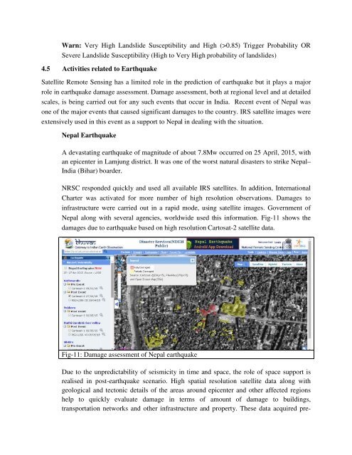
NRSC responded quickly and used all available IRS satellites. In addition, International<br />
Charter was activated <strong>for</strong> more number of high resolution observations. Damages to<br />
<strong>in</strong>frastructure were carried out <strong>in</strong> a rapid mode, us<strong>in</strong>g satellite images. Government of<br />
Nepal along with several agencies, worldwide used this <strong>in</strong><strong>for</strong>mation. Fig-11 shows the<br />
damages due to earthquake based on high resolution Cartosat-2 satellite data.<br />
Fig-11: Damage assessment of Nepal earthquake<br />
Due to the unpredictability of seismicity <strong>in</strong> time and space, the role of space support is<br />
realised <strong>in</strong> post-earthquake scenario. High spatial resolution satellite data along with<br />
geological and tectonic details of the areas around epicenter and other affected regions<br />
help to quickly evaluate damage <strong>in</strong> terms of amount of damage to build<strong>in</strong>gs,<br />
transportation networks and other <strong>in</strong>frastructure and property. These data acquired pre-