Challenges in using Remote Sensing Technology for Disaster Management

You also want an ePaper? Increase the reach of your titles
YUMPU automatically turns print PDFs into web optimized ePapers that Google loves.
output is the Level 1b MOD14 product. Process<strong>in</strong>g rout<strong>in</strong>es <strong>for</strong> are obta<strong>in</strong>ed from the<br />
NASA DRL repository.<br />
A true color image (daytime) and a thermal image (nighttime) are produced to show the<br />
coverage and cloud cover <strong>for</strong> a pass. The MOD14 product is converted to vector <strong>for</strong>mat<br />
(shape file) and attributes (satellite, date of pass and time) added to the shape file.<br />
Additionally a text file with fire locations is also produced. Products viz. shape file, text<br />
file and the image products are sent by email to the Forest Survey of India (FSI),<br />
Dehradun <strong>for</strong> value addition and dissem<strong>in</strong>ation to state <strong>for</strong>est department users.<br />
Alerts are sent by SMS service to several <strong>for</strong>est departments. The service is provided on a<br />
no-cost basis and uses <strong>for</strong>est adm<strong>in</strong>istration/ management layers l<strong>in</strong>ked with relevant<br />
mobile numbers provided by the respective state <strong>for</strong>est department. SMS alerts are sent<br />
through a gateway service provided by the state <strong>for</strong>est department. A user module <strong>for</strong><br />
ma<strong>in</strong>ta<strong>in</strong><strong>in</strong>g the mobile number database is used to ensure a current database.<br />
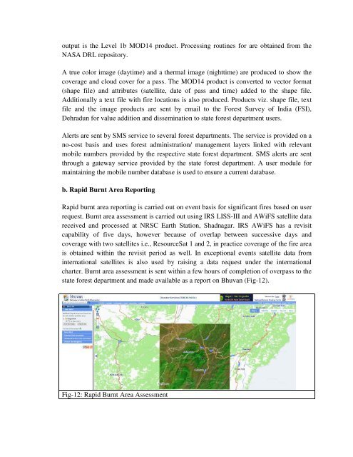
b. Rapid Burnt Area Report<strong>in</strong>g<br />
Rapid burnt area report<strong>in</strong>g is carried out on event basis <strong>for</strong> significant fires based on user<br />
request. Burnt area assessment is carried out us<strong>in</strong>g IRS LISS-III and AWiFS satellite data<br />
received and processed at NRSC Earth Station, Shadnagar. IRS AWiFS has a revisit<br />
capability of five days, however because of overlap between successive days and<br />
coverage with two satellites i.e., ResourceSat 1 and 2, <strong>in</strong> practice coverage of the fire area<br />
is obta<strong>in</strong>ed with<strong>in</strong> the revisit period as well. In exceptional events satellite data from<br />
<strong>in</strong>ternational satellites is also used by rais<strong>in</strong>g a data request under the <strong>in</strong>ternational<br />
charter. Burnt area assessment is sent with<strong>in</strong> a few hours of completion of overpass to the<br />
state <strong>for</strong>est department and made available as a report on Bhuvan (Fig-12).<br />
Fig-12: Rapid Burnt Area Assessment