Challenges in using Remote Sensing Technology for Disaster Management

You also want an ePaper? Increase the reach of your titles
YUMPU automatically turns print PDFs into web optimized ePapers that Google loves.
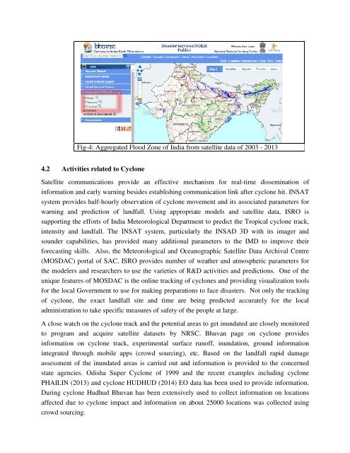
Fig-4: Aggregated Flood Zone of India from satellite data of 2003 - 2013<br />
4.2 Activities related to Cyclone<br />
Satellite communications provide an effective mechanism <strong>for</strong> real-time dissem<strong>in</strong>ation of<br />
<strong>in</strong><strong>for</strong>mation and early warn<strong>in</strong>g besides establish<strong>in</strong>g communication l<strong>in</strong>k after cyclone hit. INSAT<br />
system provides half-hourly observation of cyclone movement and its associated parameters <strong>for</strong><br />
warn<strong>in</strong>g and prediction of landfall. Us<strong>in</strong>g appropriate models and satellite data, ISRO is<br />
support<strong>in</strong>g the ef<strong>for</strong>ts of India Meteorological Department to predict the Tropical cyclone track,<br />
<strong>in</strong>tensity and landfall. The INSAT system, particularly the INSAD 3D with its imager and<br />
sounder capabilities, has provided many additional parameters to the IMD to improve their<br />
<strong>for</strong>ecast<strong>in</strong>g skills. Also, the Meteorological and Oceanographic Satellite Data Archival Centre<br />
(MOSDAC) portal of SAC, ISRO provides number of weather and atmospheric parameters <strong>for</strong><br />
the modelers and researchers to use the varieties of R&D activities and predictions. One of the<br />
unique features of MOSDAC is the onl<strong>in</strong>e track<strong>in</strong>g of cyclones and provid<strong>in</strong>g visualization tools<br />
<strong>for</strong> the local Government to use <strong>for</strong> mak<strong>in</strong>g preparations to face disasters. Not only the track<strong>in</strong>g<br />
of cyclone, the exact landfall site and time are be<strong>in</strong>g predicted accurately <strong>for</strong> the local<br />
adm<strong>in</strong>istration to take specific measures of safety of the people at large.<br />
A close watch on the cyclone track and the potential areas to get <strong>in</strong>undated are closely monitored<br />
to program and acquire satellite datasets by NRSC. Bhuvan page on cyclone provides<br />
<strong>in</strong><strong>for</strong>mation on cyclone track, experimental surface runoff, <strong>in</strong>undation, ground <strong>in</strong><strong>for</strong>mation<br />
<strong>in</strong>tegrated through mobile apps (crowd sourc<strong>in</strong>g), etc. Based on the landfall rapid damage<br />
assessment of the <strong>in</strong>undated areas is carried out and <strong>in</strong><strong>for</strong>mation is provided to the concerned<br />
state agencies. Odisha Super Cyclone of 1999 and the recent examples <strong>in</strong>clud<strong>in</strong>g cyclone<br />
PHAILIN (2013) and cyclone HUDHUD (2014) EO data has been used to provide <strong>in</strong><strong>for</strong>mation.<br />
Dur<strong>in</strong>g cyclone Hudhud Bhuvan has been extensively used to collect <strong>in</strong><strong>for</strong>mation on locations<br />
affected due to cyclone impact and <strong>in</strong><strong>for</strong>mation on about 25000 locations was collected us<strong>in</strong>g<br />
crowd sourc<strong>in</strong>g.