Brenner Basistunnel: Realisierungsstand Brenner Base Tunnel ...
Brenner Basistunnel: Realisierungsstand Brenner Base Tunnel ...
Brenner Basistunnel: Realisierungsstand Brenner Base Tunnel ...

Erfolgreiche ePaper selbst erstellen
Machen Sie aus Ihren PDF Publikationen ein blätterbares Flipbook mit unserer einzigartigen Google optimierten e-Paper Software.
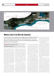
20 Österreich<br />
Austria <strong>Tunnel</strong> 2/2011<br />
• Regulatory principles and<br />
technical specifications for<br />
the lot-based tendering and<br />
executive planning<br />
• Principles for the design and<br />
construction detailing for a<br />
service lifetime of 200 years<br />
• Creation of detailed interface<br />
and type plans<br />
• Tolerances (surveying and<br />
construction method-dependent<br />
tolerances), taking<br />
into account the subsequent<br />
works<br />
• Measures for development of<br />
the railway infrastructure.<br />
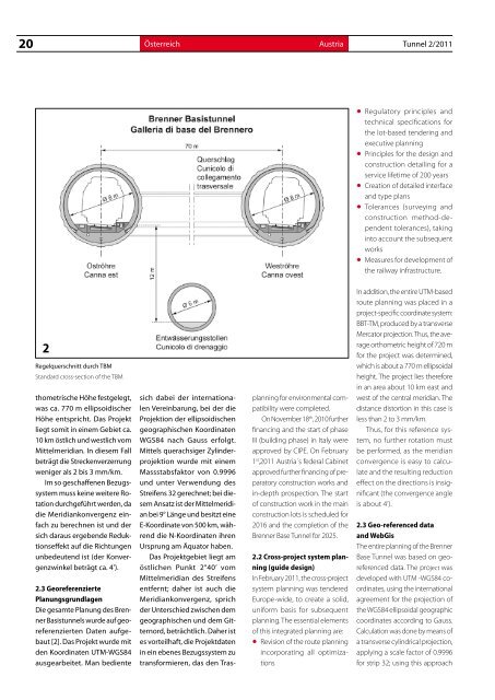
2<br />
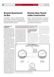
Regelquerschnitt durch TBM<br />
Standard cross-section of the TBM<br />
thometrische Höhe festgelegt,<br />
was ca. 770 m ellipsoidischer<br />
Höhe entspricht. Das Projekt<br />
liegt somit in einem Gebiet ca.<br />
10 km östlich und westlich vom<br />
Mittelmeridian. In diesem Fall<br />
beträgt die Streckenverzerrung<br />
weniger als 2 bis 3 mm/km.<br />
Im so geschaffenen Bezugssystem<br />
muss keine weitere Rotation<br />
durchgeführt werden, da<br />
die Meridiankonvergenz einfach<br />
zu berechnen ist und der<br />
sich daraus ergebende Reduktionseffekt<br />
auf die Richtungen<br />
unbedeutend ist (der Konvergenzwinkel<br />
beträgt ca. 4’).<br />
2.3 Georeferenzierte<br />
Planungsgrundlagen<br />
Die gesamte Planung des <strong>Brenner</strong><br />
<strong>Basistunnel</strong>s wurde auf georeferenzierten<br />
Daten aufgebaut<br />
[2]. Das Projekt wurde mit<br />
den Koordinaten UTM-WGS84<br />
ausgearbeitet. Man bediente<br />
sich dabei der internationalen<br />
Vereinbarung, bei der die<br />
Projektion der ellipsoidischen<br />
geographischen Koordinaten<br />
WGS84 nach Gauss erfolgt.<br />
Mittels querachsiger Zylinderprojektion<br />
wurde mit einem<br />
Massstabsfaktor von 0.9996<br />
und unter Verwendung des<br />
Streifens 32 gerechnet; bei diesem<br />
Ansatz ist der Mittelmeridian<br />
bei 9° Länge und besitzt eine<br />
E-Koordinate von 500 km, während<br />
die N-Koordinaten ihren<br />
Ursprung am Äquator haben.<br />
Das Projektgebiet liegt am<br />
östlichen Punkt 2°40’ vom<br />
Mittelmeridian des Streifens<br />
entfernt; daher ist auch die<br />
Meridiankonvergenz, sprich<br />
der Unterschied zwischen dem<br />
geographischen und dem Gitternord,<br />
beträchtlich. Daher ist<br />
es vorteilhaft, die Projektdaten<br />
in ein ebenes Bezugssystem zu<br />
transformieren, das den Trasplanning<br />
for environmental compatibility<br />
were completed.<br />
On November 18 th , 2010 further<br />
financing and the start of phase<br />
III (building phase) in Italy were<br />
approved by CIPE. On February<br />
1 st ,2011 Austria´s federal Cabinet<br />
approved further financing of preparatory<br />
construction works and<br />
in-depth prospection. The start<br />
of construction work in the main<br />
construction lots is scheduled for<br />
2016 and the completion of the<br />
<strong>Brenner</strong> <strong>Base</strong> <strong>Tunnel</strong> for 2025.<br />
2.2 Cross-project system planning<br />
(guide design)<br />
In February 2011, the cross-project<br />
system planning was tendered<br />
Europe-wide, to create a solid,<br />
uniform basis for subsequent<br />
planning. The essential elements<br />
of this integrated planning are:<br />
• Revision of the route planning<br />
incorporating all optimizations<br />
In addition, the entire UTM-based<br />
route planning was placed in a<br />
project-specific coordinate system:<br />
BBT-TM, produced by a transverse<br />
Mercator projection. Thus, the average<br />
orthometric height of 720 m<br />
for the project was determined,<br />
which is about a 770 m ellipsoidal<br />
height. The project lies therefore<br />
in an area about 10 km east and<br />
west of the central meridian. The<br />
distance distortion in this case is<br />
less than 2 to 3 mm/km.<br />
Thus, for this reference system,<br />
no further rotation must<br />
be performed, as the meridian<br />
convergence is easy to calculate<br />
and the resulting reduction<br />
effect on the directions is insignificant<br />
(the convergence angle<br />
is about 4‘).<br />
2.3 Geo-referenced data<br />
and WebGis<br />
The entire planning of the <strong>Brenner</strong><br />
<strong>Base</strong> <strong>Tunnel</strong> was based on georeferenced<br />
data. The project was<br />
developed with UTM -WGS84 coordinates,<br />
using the international<br />
agreement for the projection of<br />
the WGS84 ellipsoidal geographic<br />
coordinates according to Gauss.<br />
Calculation was done by means of<br />
a transverse cylindrical projection,<br />
applying a scale factor of 0.9996<br />
for strip 32; using this approach